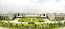
Sangareddy
This article needs additional citations for verification. (August 2017) |
Sangareddy
సంగారెడ్డి | |
|---|---|
 Collectorate building of Sangareddy | |
| Coordinates: 17°37′46″N 78°05′30″E / 17.6294°N 78.0917°ECoordinates: 17°37′46″N 78°05′30″E / 17.6294°N 78.0917°E | |
| Country | |
| State | Telangana |
| District | Sangareddy |
| Metro | Hyderabad Metropolitan Region |
| Municipal Established | 1954 |
| Named for | Sanga |
| Government | |
| • Type | Municipal Council |
| • Body | Sangareddy Municipal Corporation |
| • MLA | Jagga Reddy |
| Area | |
| • Town | 13.70 km2 (5.29 sq mi) |
| Elevation | 496 m (1,627 ft) |
| Population (2011)[1] | |
| • Town | 72,344 |
| • Density | 5,300/km2 (14,000/sq mi) |
| • Metro | 200,000 |
| Languages | |
| • Official | Telugu, Urdu |
| Time zone | UTC+5:30 (IST) |
| PIN | 502 001 |
| Telephone code | code-08455 |
| Vehicle registration | TS 15 |
Sangareddy,[2] formerly Sangareddy peta, is a town and district headquarters of Sangareddy district in the Indian state of Telangana. It was named after the ruler Sanga, who was the son of Rani Shankaramba, a ruler of Medak during the period of Nizams.[citation needed]
Government and politics[edit | edit source]
Civic administration[edit | edit source]
The Sangareddy Municipality, classified as a first grade municipality with 38 election wards, was created in 1954. The jurisdiction of the civic body is spread over an area of 13.69 km2 (5.29 sq mi).[1]
Economy[edit | edit source]
The city has three large-scale public sector industries. These are Bharat Heavy Electricals Limited (one of the Maharatna companies of the Indian government), Bharat Dynamics Limited (where one of India's most powerful missiles, Prithvi, was produced), and Ordnance Factory Medak (which manufactures the Sarath tanks for the Indian Army).
The city includes the Old Sangareddy and New Sangareddy sections. Old Sangareddy is known for its bazaars and old district jail, which has been converted to a jail museum and now called Heritage Jail Museum.[3]
Education[edit | edit source]
Schools[edit | edit source]
The following is a list of local schools and colleges:
- St. Anthony's High School, Shanthi Nagar
- Karuna High School, Sanjeeva Nagar
- Sri Vani High School, Manjeera Nagar
- Keshava Reddy Concept School, Kandi
- St.Joseph's high school, Shanthinagar
- BVM Concept school, Sangareddy
- Shree Gayathri high school, Sangareddy
- Pioneers International School
- Government High school, Sangareddy
- Gandhi Centenary High School
- MNR School of Excellence, MNR campus, Sangareddy.
- Rishi high school
- Daffodils high school
- Sri Sai Krishna High School
- Nagarjuna Junior College
- Anthony Junior College
- Government Tara Degree College
- Wisdom Degree College
- Ellenki Degree College
- St. Anthony's High School, Vidya Nagar
- St. Peter's High School
- St. Arnold's High School
- Akshaya Junior College
- Spectra High School
- Kendriya vidyalaya, ODF
- Sri Chaitanya Junior College, Ammenpur
- Krishnaveni Talent school
- Spoorthy degree college
- Kakatiya Techno school
- Sahiti public high school
- Bhavani Primary School
- National Public school
Higher Education[edit | edit source]
The following are the centres of higher education in Sangareddy district:
- Indian Institute of Technology Hyderabad, Kandi Village, Sangareddy
- MNR Medical College, MNR Nagar, Fasalwadi, Narasapur Road, Sangareddy-502294
- JNTUH College of Engineering Sulthanpur
- GITAM University, Rudraram
- Prof N Ranga Agricultural University
- Horticultural University
Transport facilities.[edit | edit source]
Roads[edit | edit source]
The NH-65 road passes through the town.
About 15 km away from Sangareddy is an outer ring road which connects to Shamshabad airport – Rajiv Gandhi International Airport, Hyderabad, Gachibowli, and Medchal.
A bypass road to NH44 is linked from Sangareddy to Shadnagar through Chevella.
Long distance travel options are also available from Sangareddy to Tirupati, Vizag, Vijayawada, and Kandukooru directly.
Rail[edit | edit source]
The nearest railway stations are Shankarpalli railway station which is about 22 km away, Lingampally, which is about 30 km away, Secunderabad (about 50 km away) and Nampally Station, which is around 53 km away.
Air[edit | edit source]
The nearest air transport facility is Hyderabad International Airport, which is 70 km from Sangareddy.
Media[edit | edit source]
The Telugu dailies publishers in the city are Eenadu, Andhra Jyothy, and Sakshi. Apart from the local language, there are also English papers such as The Hindu, The Times of India, and The Hans India.
References[edit | edit source]
- ↑ 1.0 1.1 1.2 "Urban Local Body Information" (PDF). Directorate of Town and Country Planning. Government of Telangana. Archived from the original (PDF) on 15 June 2016. Retrieved 28 June 2016.
- ↑ https://sangareddy.telangana.gov.in/
- ↑ Arif, Mohd. (10 March 2015). "First-ever Jail Museum". The Hindu. Retrieved 28 June 2016.
