


No edit summary |
m cleanup |
||
| (One intermediate revision by the same user not shown) | |||
| Line 1: | Line 1: | ||
{{About|the town in India|other things named Badami|Badami (disambiguation)}} | {{Short description|Town in Karnataka, India}} | ||
{{About|the town in India|other things named Badami|Badami (disambiguation)|the Hindu mythological character|Ilvala and Vatapi}} | |||
{{Use dmy dates|date=September 2019}} | {{Use dmy dates|date=September 2019}} | ||
<!-- See [[ | <!-- See [[Bharatpedia:WikiProject Indian cities]] for details --> | ||
{{Infobox settlement | {{Infobox settlement | ||
| name = Badami | | name = Badami | ||
| Line 15: | Line 16: | ||
| pushpin_map = India Karnataka#India | | pushpin_map = India Karnataka#India | ||
| subdivision_type = Country | | subdivision_type = Country | ||
| subdivision_name = | | subdivision_name = India | ||
| subdivision_type1 = [[States and territories of India|State]] | | subdivision_type1 = [[States and territories of India|State]] | ||
| subdivision_name1 = [[Karnataka]] | | subdivision_name1 = [[Karnataka]] | ||
| Line 45: | Line 46: | ||
}} | }} | ||
'''Badami''', formerly known as ''' | '''Badami''' ({{ipa|kn|baːd̪aːmi|lang}}), formerly known as '''Vātāpi''' (Sanskrit: from ''āpi'', ‘friend, ally’; ‘having the wind (vāta) as an ally’), is a town and headquarters of a [[taluk]] by the same name, in the [[Bagalkot district]] of Karnataka, India. It was the regal capital of the [[Badami Chalukyas]] from 540 to 757. It is famous for its rock cut monuments such as the [[Badami cave temples]], as well as the structural temples such as the [[Bhutanatha group of temples, Badami|Bhutanatha temples]], [[Badami Shivalaya]] and Jambulingesvara Temple. It is located in a ravine at the foot of a rugged, red [[sandstone]] outcrop that surrounds [[Agastya lake]]. | ||
Badami has been selected as one of the heritage cities for [[HRIDAY - Heritage City Development and Augmentation Yojana]] scheme of Government of India. | |||
==History== | ==History== | ||
{{Main article | Chalukya dynasty|Badami Chalukya Architecture}} | {{Main article|Chalukya dynasty|Badami Chalukya Architecture}} | ||
=== | |||
===History=== | |||
[[File:Map of the Chalukyas.png|left|thumb|Extent of [[Badami Chalukyas]] Empire, 636 CE, 740 CE]] | |||
[[Pulakeshin I]] an early ruler of the Chalukyas, is generally regarded as having founded the Badami Chalukya dynasty in 540. An inscription record of this king engraved on a boulder in Badami records the fortification of the hill above 'Vatapi' in 544. Pulakeshin's choice of this location for his capital was likely due to strategic considerations, as Badami is protected on three sides by rugged sandstone cliffs. His son [[Kirtivarman I]] and his brother [[Mangalesha]] constructed the cave temples located there. The Agastya lake (formerly Vatapi lake) is a man-made lake, a water infrastructure project completed in the 7th century, likely as a strategic source of water for the capital and around which many Hindu temples were constructed.<ref>M. A. Dhaky; Michael W. Meister (1983). Encyclopaedia of Indian Temple Architecture: Volume 1 Part 2 South India Text & Plates. University of Pennsylvania Press. pp. 3–8 and 57, {{ISBN|978-0-8122-7992-4}}</ref><ref>Julia Hegewald (2001), Water Architecture in South Asia: A Study of Types, Developments and Meanings, Brill Academic, {{ISBN|978-90-04-12352-6}}, pp. 85–91</ref> | |||
Kirtivarman I strengthened Vatapi and had three sons, [[Pulakeshin II]], Vishnuvardhana and Buddhavarasa, who were minors at the time of his death. [[Kirtivarman I]]'s brother [[Mangalesha]] ruled the kingdom, as is mentioned in the [[Mahakuta Pillar]] inscription. In 610, the famous [[Pulakeshin II]] came to power and ruled between up to 642. Vatapi was the capital of the Early [[Chalukyas]], who ruled much of [[Karnataka]], [[Maharashtra]], parts of [[Tamil Nadu]] and [[Andhra Pradesh]] between the 6th and 8th centuries. | |||
[[Image:6th century Kannada inscription in cave temple number 3 at Badami.jpg|thumb|200px|right|Old Kannada inscription of Chalukya King Mangalesha dated 578 CE at Badami cave temple no.3]] | |||
[[Image:Badami | |||
Badami Chalukyas | Under the Badami Chalukyas, Badami emerged as one of the regional centres of art in the Malprabha valley – a cradle of Hindu and Jain temple architecture schools. Both Dravida and Nagara styles of temples are found in Badami, along with those in Aihole, Pattadakal and Mahakuta.<ref name="Michell, George 2014 pp. 12">Michell, George (2014). Temple Architecture and Art of the Early Chalukyas. India : Niyogi Books. pp. 12–17. {{ISBN|978-93-83098-33-0}}.</ref> Many of the temples in Badami, such as the Eastern Bhutanatha group and the Jambulingesvara temple, were built between the 6th and 8th century. They are key to understanding the development of temple architecture and arts, as well as the Karnata tradition of arts around the mid 1st-millennium CE.<ref name="Michell, George 2014 pp. 12"/> | ||
[[ | When Pulakeshin II was defeated by [[Narasimhavarman I|Narasimhavarman]] of Pallavas in 642CE, the Pallava army descended upon the city of Vatapi, indulging in the riches accumulated over generations by the Chalukyas. The royal palace was ransacked, men were slain, women taken captive, and temples stripped of their treasures. A later oral tradition claims that among the spoils was the revered ‘Vatapi Ganapati’ idol, now celebrated in Carnatic music. This idol was allegedly transported to the Uthrapathiswaraswamy temple near present-day Nagapattinam in Pallava territory. As the city burned, its survivors—immigrant preachers, architects, traders, officials, and laborers—gathered whatever they could and fled, not to return for many years. Narasimhavarman Mahamalla seized the victory pillar that Pulakeshin II had once erected in the city after he had defeated [[Harsha]] and Vengi, and brought it to Kanchi. A Pallava inscription, written in their script and still found in Badami, proclaims the attack as a fierce retaliation for Pulakeshin's past conquests.<ref>{{Cite book |last=Kanisetti |first=Anirudh |title=Lords of the Deccan |publisher=Juggernaut Books |year=2022 |isbn=9789391165055 |location=New Delhi |language=English}}</ref> | ||
[[ | These sites also contain many increasingly sophisticated temples and arts from the Rashtrakutas and Later Chalukyas, such as the Northern Bhutanatha group of temples and the [[Yellamma Temple, Badami|Yellamma Temple]], completed through the early 13th century. Thereafter, states George Michell, this region was ravaged and temples ruined by invading armies of the [[Turco-Persian tradition|Turko-Persian]] [[Delhi Sultanate]]. | ||
Badami and other sites in the Malprabha region were fought over by the Hindu monarchs of the [[Vijayanagara Empire]] and the [[Turko-Persian]] [[Deccan sultanates|Sultans of Deccan]]. The Vijayanagara emperors commissioned expanded fort walls in Badami and elsewhere. Many ruins, the fort and some well preserved temples in high hillocks survive and attest to the rich heritage of Badami and nearby sites from these centuries.<ref>Michell, George (2014). Temple Architecture and Art of the Early Chalukyas. India : Niyogi Books. pp. 15–17, 32–39. {{ISBN|978-93-83098-33-0}}.</ref> The [[Turko-Persian]] [[Deccan Sultanates|sultanate rule]] that followed the Vijayanagara period forcefully and aggressively islamized the site. This is attested by two monuments here. One is the Markaj Jumma near the entrance of the cave temples and structural temples. It has the 18th-century tomb of Abdul Malik Aziz. The other Islamic monument is also of modern era – the [[dargah]] of Sayyid Hazrat Badshah near the Upper Shivalaya.<ref>Michell, George (2014). Temple Architecture and Art of the Early Chalukyas. India : Niyogi Books. pp. 64–65. {{ISBN|978-93-83098-33-0}}.</ref> | |||
===Inscriptions=== | ===Inscriptions=== | ||
| Line 72: | Line 76: | ||
=== Paintings === | === Paintings === | ||
{{main|Chitra (art)}} | {{main|Chitra (art)}} | ||
The Badami cave temples were likely fully painted inside by late 6th century | [[File:Lord Vishnu - Badami.jpg|thumb]] | ||
The Badami cave temples were likely fully painted inside by the late 6th century. Most of these paintings are now lost, except for the mural fragments, bands and faded sections found in Cave 3 (Vaishnava, Hindu) and Cave 4 (Jain). The original murals are most clearly evidenced in Cave 3, where inside the Vishnu temple, there are paintings of secular art as well as murals that depict legends of Shiva and Parvati on the ceiling and in parts less exposed to the natural elements. These are among the earliest known paintings of Hindu legends in India that can be dated.<ref>Stella Kramrisch (1932), [https://archive.org/details/JournalOfTheIndianSocietyOfOrientalAr/page/n67/mode/2up Paintings at Badami], Journal of Indian Society for Oriental Art, Volume IV, Number 1, pp. 57–61</ref><ref>KV Soundara Rajan (1981), Cave Temples of the Deccan: Number 3, Archaeological Survey of India, pp. 64–65 with Plate XV that presents a part of the Badami mural</ref> | |||
==In | ==In literature== | ||
Badami is | Badami is predominantly featured in the Tamil language historical fiction novel series [[Sivagamiyin Sapatham]], written by [[Kalki Krishnamurthy]]. | ||
Hindi Film [[Guru]] featuring Abisek Bachan was shot in Badami. | |||
A part of the Tamil film [[Taj Mahal (1999 film)|Taj Mahal]] was shot in Badami, with a part of the song 'Adi Manja Kilange' shot at Agastya Teertha. | |||
==Gallery== | |||
{{Main article |Badami cave temples|Bhutanatha group}} | {{Main article |Badami cave temples|Bhutanatha group}} | ||
{{Gallery | {{Gallery | ||
| Line 99: | Line 106: | ||
==Administration== | ==Administration== | ||
=== | ===Taluks=== | ||
The Badami Taluka has thirty-four [[panchayat village]]s:<ref name="Panchayat-Dir-2011">{{Cite web|title=Reports of National Panchayat Directory: Village Panchayat Names of Badami, Bagalkot, Karnataka|publisher=Registrar General & Census Commissioner, India|url=http://panchayatdirectory.gov.in/adminreps/viewpansumSQL.asp?selstate=5753&parenttype=B&ptype=V|archive-url=https://web.archive.org/web/20111113121900/http://panchayatdirectory.gov.in/adminreps/viewpansumSQL.asp?selstate=5753&parenttype=B&ptype=V|archive-date=13 November 2011|url-status=dead|access-date=10 April 2013}}</ref> | The Badami Taluka has thirty-four [[panchayat village]]s:<ref name="Panchayat-Dir-2011">{{Cite web|title=Reports of National Panchayat Directory: Village Panchayat Names of Badami, Bagalkot, Karnataka|publisher=Registrar General & Census Commissioner, India|url=http://panchayatdirectory.gov.in/adminreps/viewpansumSQL.asp?selstate=5753&parenttype=B&ptype=V|archive-url=https://web.archive.org/web/20111113121900/http://panchayatdirectory.gov.in/adminreps/viewpansumSQL.asp?selstate=5753&parenttype=B&ptype=V|archive-date=13 November 2011|url-status=dead|access-date=10 April 2013}}</ref> | ||
{| | {{div col|colwidth=18em}} | ||
* [[Adagal]] | * [[Adagal]] | ||
* [[Anawal]] | * [[Anawal]] | ||
| Line 117: | Line 119: | ||
* Hansanur | * Hansanur | ||
* Hebbali | * Hebbali | ||
* Hosur | * Hosur | ||
* Huligeri | * Huligeri | ||
| Line 127: | Line 128: | ||
* Kataraki | * Kataraki | ||
* Kelavadi | * Kelavadi | ||
* Khanapur S.K. | * Khanapur S.K. | ||
* Kittali | * Kittali | ||
| Line 137: | Line 137: | ||
* Mutalgeri | * Mutalgeri | ||
* Nagaral S.P. | * Nagaral S.P. | ||
* Nandikeshwar | * Nandikeshwar | ||
* Neelgund | * Neelgund | ||
| Line 145: | Line 144: | ||
* Pattadkal | * Pattadkal | ||
* Sulikeri | * Sulikeri | ||
{{div col end}} | |||
==Geography== | ==Geography== | ||
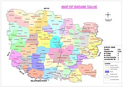
[[File:Badami Taluk.jpg|thumb|Badami Taluk Map before creation of Guledgud Taluk]] | [[File:Badami Taluk.jpg|thumb|Badami Taluk Map before creation of Guledgud Taluk]] | ||
[[File:Badami Taluk ZP Constituency Map.jpg|thumb|Badami Taluk ZP Constituency Map before creation of Guledgud Taluk]] | [[File:Badami Taluk ZP Constituency Map.jpg|thumb|Badami Taluk ZP Constituency Map before creation of Guledgud Taluk]] | ||
Badami is located at {{coord|15.92|N|75.68|E|}}.<ref>{{cite web|url=http://www.fallingrain.com/world/IN/19/Badami.html |title=Falling Rain Genomics, Inc - Badami |publisher=Fallingrain.com |access-date=12 February 2013}}</ref> It has an average elevation of 586 metres (1922 ft). It is located at the mouth of a ravine between two rocky hills and surrounds Agastya tirtha water reservoir on the three other sides. The total area of the town is 10.3 square kilometers. | Badami is located at {{coord|15.92|N|75.68|E|}}.<ref>{{cite web|url=http://www.fallingrain.com/world/IN/19/Badami.html |title=Falling Rain Genomics, Inc. - Badami |publisher=Fallingrain.com |access-date=12 February 2013}}</ref> It has an average elevation of 586 metres (1922 ft). It is located at the mouth of a ravine between two rocky hills and surrounds Agastya tirtha water reservoir on the three other sides. The total area of the town is 10.3 square kilometers. | ||
It is located 30 kilometers from [[Bagalkot]], 128 kilometers from [[Bijapur, Karnataka|Bijapur]], 132 kilometers from [[Hubli]], 46 kilometers from [[Aihole]], another ancient town, and 589 kilometers from [[Bangalore]],<ref>Railway ticket (Bijapur express) from Bangalore to Badami</ref> the state capital. | It is located 30 kilometers from [[Bagalkot]], 128 kilometers from [[Bijapur, Karnataka|Bijapur]], 132 kilometers from [[Hubli]], 46 kilometers from [[Aihole]], another ancient town, and 589 kilometers from [[Bangalore]],<ref>Railway ticket (Bijapur express) from Bangalore to Badami</ref> the state capital. | ||
| Line 158: | Line 157: | ||
*Spring – Jan to March | *Spring – Jan to March | ||
*Monsoons – July to October that contributes to rainfall | *Monsoons – July to October that contributes to rainfall | ||
*Winter – November to | *Winter – November to February | ||
The temperature ranges from minimum | The temperature ranges from a minimum 22 degrees to a maximum 40 degrees in summer and from 14 to 29 degrees in winter. The average rainfall is around 68 cm (680 mm). The best time to visit Badami is considered to be between the low-humid season from November to March. | ||
The climate has made it a safe haven for the monkeys of | The climate of Badami has made it a safe haven for the monkeys of southern India. Tourists often flock to Badami for the opportunity to see monkeys interact in a natural environment. | ||
== Demographics == | == Demographics == | ||
As of [[2011 Indian Census]], Badami had a total population of 30,943, of which 15,539 were males and 15,404 were females. | As of the [[2011 Indian Census]], Badami had a total population of 30,943, of which 15,539 were males and 15,404 were females. The population within the age group of 0 to 6 years was 3,877. The total number of literates in Badami was 22,093, which constituted 71.4% of the population with male literacy of 78.1% and female literacy of 64.7%. The effective literacy rate of 7+ population of Badami was 81.6%, of which male literacy rate was 89.7% and female literacy rate was 73.6%. The [[Scheduled Castes and Scheduled Tribes]] population was 4,562 and 1,833 respectively. Badami had 6214 households in 2011.<ref name="Census2011Gov">{{cite web |title=Census of India: Badami |url=http://www.censusindia.gov.in/pca/SearchDetails.aspx?Id=680086 |website=www.censusindia.gov.in |access-date=14 December 2019}}</ref> | ||
{{As of|alt=As of the [[2001 Indian census]]|2001}},<ref>{{cite web|url=http://www.censusindia.net/results/town.php?stad=A&state5=999|archive-url=https://web.archive.org/web/20040616075334/http://www.censusindia.net/results/town.php?stad=A&state5=999|archive-date=16 June 2004|title= Census of India 2001: Data from the 2001 Census, including cities, villages and towns (Provisional)|access-date=1 November 2008|publisher= Census Commission of India}}</ref> Badami had a population of 25,851. Males constituted 51% of the population and females 49%. Badami had an average literacy rate of 64.8%, comparable to the national average of 65%; with 59% of the males and 41% of females literate. 14% of the population was under 6 years of age. | {{As of|alt=As of the [[2001 Indian census]]|2001}},<ref>{{cite web|url=http://www.censusindia.net/results/town.php?stad=A&state5=999|archive-url=https://web.archive.org/web/20040616075334/http://www.censusindia.net/results/town.php?stad=A&state5=999|archive-date=16 June 2004|title= Census of India 2001: Data from the 2001 Census, including cities, villages and towns (Provisional)|access-date=1 November 2008|publisher= Census Commission of India}}</ref> Badami had a population of 25,851. Males constituted 51% of the population and females 49%. Badami had an average literacy rate of 64.8%, comparable to the national average of 65%; with 59% of the males and 41% of females literate. 14% of the population was under 6 years of age. | ||
The main language is [[Kannada]]. | The main language spoken is [[Kannada]]. | ||
{{wide image|Agastya_Lake.jpg|800px|Panoramic view of Agastya Teertha, Badami.}} | {{wide image|Agastya_Lake.jpg|800px|Panoramic view of Agastya Teertha, Badami.}} | ||
==Climbing== | ==Climbing== | ||
Badami's red sandstone cliffs are popular amongst local and international climbers. This is | Badami's red sandstone cliffs are popular amongst local and international climbers. This is popular location for free sport climbing and bouldering. The cliffs have a horizontal crack systems, similar to [[Gunks]]. There are over 150 bolted routes and multiple routes for free climbing. Gerhard Schaar,<ref>{{cite web |url=http://www.gerhardschaar.com/home.html |title=Gerhard Schaar Official |publisher=gerhardschaar.com |access-date=15 October 2015 |archive-date=28 September 2015 |archive-url=https://web.archive.org/web/20150928141501/http://www.gerhardschaar.com/home.html |url-status=dead }}</ref> a German Climber and Pranesh Manchaiah, a local climber from Bangalore, were instrumental in setting up the sport routes by driving a project called 'Bolts for Bangalore'.<ref>{{cite web |url=http://www.climbing.com/exclusive/above/boltsforbangalore/ |title=Bolts for Bangalore |publisher=Climbing.com |access-date=15 January 2012 |archive-url=https://web.archive.org/web/20120312045501/http://www.climbing.com/exclusive/above/boltsforbangalore/ |archive-date=12 March 2012 |url-status=dead }}</ref> | ||
== See also == | == See also == | ||
{| | {{div col|colwidth=35em}} | ||
*[[Aihole]] | *[[Aihole]] | ||
*[[Badami Cave Temples]] | *[[Badami Cave Temples]] | ||
| Line 191: | Line 184: | ||
*[[Chalukya]] | *[[Chalukya]] | ||
*[[Climbing locations in India]] | *[[Climbing locations in India]] | ||
*[[Gadag]] | *[[Gadag]] | ||
*[[Indian rock-cut architecture]] | *[[Indian rock-cut architecture]] | ||
| Line 199: | Line 191: | ||
*[[Sidlaphadi]] | *[[Sidlaphadi]] | ||
*[[North Karnataka]] | *[[North Karnataka]] | ||
*[[Pattadakal]] | *[[Pattadakal]] | ||
*[[Pulakeshin II]] | *[[Pulakeshin II]] | ||
| Line 206: | Line 197: | ||
*[[Sudi, India|Sudi]] | *[[Sudi, India|Sudi]] | ||
*[[Tourism in Karnataka]] | *[[Tourism in Karnataka]] | ||
*[[Dravidian architecture#Badami Chalukyas|Dravidian architecture - Badami Chalukyas]] | *[[Dravidian architecture#Badami Chalukyas|Dravidian architecture - Badami Chalukyas]] | ||
*[[Hindu temple architecture#Badami Chalukya architecture|Hindu temple architecture - Badami Chalukya architecture]] | *[[Hindu temple architecture#Badami Chalukya architecture|Hindu temple architecture - Badami Chalukya architecture]] | ||
*[[Political history of medieval Karnataka#Badami Chalukyas|Political history of medieval Karnataka - Badami Chalukyas]] | *[[Political history of medieval Karnataka#Badami Chalukyas|Political history of medieval Karnataka - Badami Chalukyas]] | ||
*[[Architecture of Karnataka#Badami Chalukya architecture|Architecture of Karnataka - Badami Chalukya architecture]] | *[[Architecture of Karnataka#Badami Chalukya architecture|Architecture of Karnataka - Badami Chalukya architecture]] | ||
*[[List of Indian monarchs#Chalukyas of Badami (543–757)|Chalukyas of Badami]] | *[[List of Indian monarchs#Chalukyas of Badami (543–757)|Chalukyas of Badami]]{{Broken anchor|date=2024-06-02|bot=User:Cewbot/log/20201008/configuration|target_link=List of Indian monarchs#Chalukyas of Badami (543–757)|reason= The anchor (Chalukyas of Badami (543–757)) [[Special:Diff/913703667|has been deleted]].}} | ||
{{div col end}} | |||
== References == | == References == | ||
| Line 240: | Line 230: | ||
[[Category:Cities and towns in Bagalkot district]] | [[Category:Cities and towns in Bagalkot district]] | ||
[[Category:Former | [[Category:Former capitals in India]] | ||
[[Category:Tourism in Karnataka]] | [[Category:Tourism in Karnataka]] | ||
[[Category:Climbing areas of India]] | |||
Latest revision as of 04:23, 14 March 2026
Badami
Vatapi | |
|---|---|
Town | |
 | |
  Badami  Badami | |
| Coordinates: 15°55′12″N 75°40′49″E / 15.92000°N 75.68028°E | |
| Country | India |
| State | Karnataka |
| District | Bagalkot |
| Area | |
| • Total | 10.9 km2 (4.2 sq mi) |
| Elevation | 586 m (1,923 ft) |
| Population (2011)[1] | |
| • Total | 30,943 |
| • Density | 2,800/km2 (7,400/sq mi) |
| Languages | |
| • Official | Kannada[2] |
| Time zone | UTC+5:30 (IST) |
| PIN | 587 201 |
| Telephone code | 08357 |
| Website | http://www.badamitown.mrc.gov.in/ |
Badami (Kannada: [baːd̪aːmi]), formerly known as Vātāpi (Sanskrit: from āpi, ‘friend, ally’; ‘having the wind (vāta) as an ally’), is a town and headquarters of a taluk by the same name, in the Bagalkot district of Karnataka, India. It was the regal capital of the Badami Chalukyas from 540 to 757. It is famous for its rock cut monuments such as the Badami cave temples, as well as the structural temples such as the Bhutanatha temples, Badami Shivalaya and Jambulingesvara Temple. It is located in a ravine at the foot of a rugged, red sandstone outcrop that surrounds Agastya lake.
Badami has been selected as one of the heritage cities for HRIDAY - Heritage City Development and Augmentation Yojana scheme of Government of India.
History[edit | edit source]
History[edit | edit source]

Pulakeshin I an early ruler of the Chalukyas, is generally regarded as having founded the Badami Chalukya dynasty in 540. An inscription record of this king engraved on a boulder in Badami records the fortification of the hill above 'Vatapi' in 544. Pulakeshin's choice of this location for his capital was likely due to strategic considerations, as Badami is protected on three sides by rugged sandstone cliffs. His son Kirtivarman I and his brother Mangalesha constructed the cave temples located there. The Agastya lake (formerly Vatapi lake) is a man-made lake, a water infrastructure project completed in the 7th century, likely as a strategic source of water for the capital and around which many Hindu temples were constructed.[3][4]
Kirtivarman I strengthened Vatapi and had three sons, Pulakeshin II, Vishnuvardhana and Buddhavarasa, who were minors at the time of his death. Kirtivarman I's brother Mangalesha ruled the kingdom, as is mentioned in the Mahakuta Pillar inscription. In 610, the famous Pulakeshin II came to power and ruled between up to 642. Vatapi was the capital of the Early Chalukyas, who ruled much of Karnataka, Maharashtra, parts of Tamil Nadu and Andhra Pradesh between the 6th and 8th centuries.

Under the Badami Chalukyas, Badami emerged as one of the regional centres of art in the Malprabha valley – a cradle of Hindu and Jain temple architecture schools. Both Dravida and Nagara styles of temples are found in Badami, along with those in Aihole, Pattadakal and Mahakuta.[5] Many of the temples in Badami, such as the Eastern Bhutanatha group and the Jambulingesvara temple, were built between the 6th and 8th century. They are key to understanding the development of temple architecture and arts, as well as the Karnata tradition of arts around the mid 1st-millennium CE.[5]
When Pulakeshin II was defeated by Narasimhavarman of Pallavas in 642CE, the Pallava army descended upon the city of Vatapi, indulging in the riches accumulated over generations by the Chalukyas. The royal palace was ransacked, men were slain, women taken captive, and temples stripped of their treasures. A later oral tradition claims that among the spoils was the revered ‘Vatapi Ganapati’ idol, now celebrated in Carnatic music. This idol was allegedly transported to the Uthrapathiswaraswamy temple near present-day Nagapattinam in Pallava territory. As the city burned, its survivors—immigrant preachers, architects, traders, officials, and laborers—gathered whatever they could and fled, not to return for many years. Narasimhavarman Mahamalla seized the victory pillar that Pulakeshin II had once erected in the city after he had defeated Harsha and Vengi, and brought it to Kanchi. A Pallava inscription, written in their script and still found in Badami, proclaims the attack as a fierce retaliation for Pulakeshin's past conquests.[6]
These sites also contain many increasingly sophisticated temples and arts from the Rashtrakutas and Later Chalukyas, such as the Northern Bhutanatha group of temples and the Yellamma Temple, completed through the early 13th century. Thereafter, states George Michell, this region was ravaged and temples ruined by invading armies of the Turko-Persian Delhi Sultanate.
Badami and other sites in the Malprabha region were fought over by the Hindu monarchs of the Vijayanagara Empire and the Turko-Persian Sultans of Deccan. The Vijayanagara emperors commissioned expanded fort walls in Badami and elsewhere. Many ruins, the fort and some well preserved temples in high hillocks survive and attest to the rich heritage of Badami and nearby sites from these centuries.[7] The Turko-Persian sultanate rule that followed the Vijayanagara period forcefully and aggressively islamized the site. This is attested by two monuments here. One is the Markaj Jumma near the entrance of the cave temples and structural temples. It has the 18th-century tomb of Abdul Malik Aziz. The other Islamic monument is also of modern era – the dargah of Sayyid Hazrat Badshah near the Upper Shivalaya.[8]
Inscriptions[edit | edit source]
Badami has eighteen inscriptions, with important historical information. The first Sanskrit inscription in old Kannada script, on a hillock dates back to 543 CE, from the period of Pulakeshin I (Vallabheswara), the second is the 578 CE cave inscription of Mangalesha in Kannada language and script and the third is the Kappe Arabhatta records, the earliest available Kannada poetry in tripadi (three line) metre.[9][10][11] one inscription near the Bhuthanatha temple also has inscriptions dating back to the 12th century in Jain rock-cut temple dedicated to the Tirtankara Adinatha.
Paintings[edit | edit source]

The Badami cave temples were likely fully painted inside by the late 6th century. Most of these paintings are now lost, except for the mural fragments, bands and faded sections found in Cave 3 (Vaishnava, Hindu) and Cave 4 (Jain). The original murals are most clearly evidenced in Cave 3, where inside the Vishnu temple, there are paintings of secular art as well as murals that depict legends of Shiva and Parvati on the ceiling and in parts less exposed to the natural elements. These are among the earliest known paintings of Hindu legends in India that can be dated.[12][13]
In literature[edit | edit source]
Badami is predominantly featured in the Tamil language historical fiction novel series Sivagamiyin Sapatham, written by Kalki Krishnamurthy. Hindi Film Guru featuring Abisek Bachan was shot in Badami. A part of the Tamil film Taj Mahal was shot in Badami, with a part of the song 'Adi Manja Kilange' shot at Agastya Teertha.
Gallery[edit | edit source]
-
 Agastya lake
 -
 Yellamma temple at Badami, early phase construction, 11th century
 -
 Bhutanatha group of temples facing the Agasythya Tank
 -
 Mallikarjuna group of temples
 -
 Markaj Jumma in Badami
 -
 Northern Fort Temple
 -
 Floor plans of the 8th-century Bhutanatha temple near the lake
 -
 Mallegitti Shivalaya on the top of a rock, best preserved Dravida architecture in Badami
 -
 Vishnu seated on Adishesha
 -
 Brahma on Hamsa in Cave 3 ceiling
 -
 Bahubali in cave 4
 -
 Jain Parshvanatha in cave 4
 -
 Vishnu, Shiva and Brahma in a small rock carving monument
 -
 Hindu reliefs on a Badami boulder
 -
 Some Badami cave monuments show evidence of paintings


.jpg)

,_Shiva_above_Nandi,_Brahma_above_Hamsa,_Badami_monuments_Karnataka.jpg)


Administration[edit | edit source]
Taluks[edit | edit source]
The Badami Taluka has thirty-four panchayat villages:[14]
- Adagal
- Anawal
- Belur
- Cholachagudda
- Fakirbhudihal
- Haldur
- Halkurki
- Hansanur
- Hebbali
- Hosur
- Huligeri
- Hullikeri
- Jalihal
- Jamankatti
- Kaknur
- Katageri
- Kataraki
- Kelavadi
- Khanapur S.K.
- Kittali
- Kotikal
- Layadgundi
- Mamtageri
- Mangalore
- Mustigeri
- Mutalgeri
- Nagaral S.P.
- Nandikeshwar
- Neelgund
- Neeralkeri
- Neerbhudihal
- Parvati
- Pattadkal
- Sulikeri
Geography[edit | edit source]


Badami is located at 15°55′N 75°41′E / 15.92°N 75.68°E.[15] It has an average elevation of 586 metres (1922 ft). It is located at the mouth of a ravine between two rocky hills and surrounds Agastya tirtha water reservoir on the three other sides. The total area of the town is 10.3 square kilometers.
It is located 30 kilometers from Bagalkot, 128 kilometers from Bijapur, 132 kilometers from Hubli, 46 kilometers from Aihole, another ancient town, and 589 kilometers from Bangalore,[16] the state capital.
Climate[edit | edit source]
- Summer – March to June
- Spring – Jan to March
- Monsoons – July to October that contributes to rainfall
- Winter – November to February
The temperature ranges from a minimum 22 degrees to a maximum 40 degrees in summer and from 14 to 29 degrees in winter. The average rainfall is around 68 cm (680 mm). The best time to visit Badami is considered to be between the low-humid season from November to March.
The climate of Badami has made it a safe haven for the monkeys of southern India. Tourists often flock to Badami for the opportunity to see monkeys interact in a natural environment.
Demographics[edit | edit source]
As of the 2011 Indian Census, Badami had a total population of 30,943, of which 15,539 were males and 15,404 were females. The population within the age group of 0 to 6 years was 3,877. The total number of literates in Badami was 22,093, which constituted 71.4% of the population with male literacy of 78.1% and female literacy of 64.7%. The effective literacy rate of 7+ population of Badami was 81.6%, of which male literacy rate was 89.7% and female literacy rate was 73.6%. The Scheduled Castes and Scheduled Tribes population was 4,562 and 1,833 respectively. Badami had 6214 households in 2011.[1]
As of the 2001 Indian census[update],[17] Badami had a population of 25,851. Males constituted 51% of the population and females 49%. Badami had an average literacy rate of 64.8%, comparable to the national average of 65%; with 59% of the males and 41% of females literate. 14% of the population was under 6 years of age.
The main language spoken is Kannada.

Climbing[edit | edit source]
Badami's red sandstone cliffs are popular amongst local and international climbers. This is popular location for free sport climbing and bouldering. The cliffs have a horizontal crack systems, similar to Gunks. There are over 150 bolted routes and multiple routes for free climbing. Gerhard Schaar,[18] a German Climber and Pranesh Manchaiah, a local climber from Bangalore, were instrumental in setting up the sport routes by driving a project called 'Bolts for Bangalore'.[19]
See also[edit | edit source]
- Aihole
- Badami Cave Temples
- Badami Chalukya Architecture
- Banashankari Amma Temple at Cholachagudd
- Chalukya
- Climbing locations in India
- Gadag
- Indian rock-cut architecture
- List of State Protected Monuments in Karnataka
- Lakkundi
- Mahakuta
- Sidlaphadi
- North Karnataka
- Pattadakal
- Pulakeshin II
- Siege of Badami
- Sivagamiyin sabadham
- Sudi
- Tourism in Karnataka
- Dravidian architecture - Badami Chalukyas
- Hindu temple architecture - Badami Chalukya architecture
- Political history of medieval Karnataka - Badami Chalukyas
- Architecture of Karnataka - Badami Chalukya architecture
- Chalukyas of Badami[broken anchor]
References[edit | edit source]
- ↑ 1.0 1.1 "Census of India: Badami". www.censusindia.gov.in. Retrieved 14 December 2019.
- ↑ "52nd REPORT OF THE COMMISSIONER FOR LINGUISTIC MINORITIES IN INDIA" (PDF). nclm.nic.in. Ministry of Minority Affairs. p. 18. Archived from the original (PDF) on 25 May 2017. Retrieved 24 December 2018.
- ↑ M. A. Dhaky; Michael W. Meister (1983). Encyclopaedia of Indian Temple Architecture: Volume 1 Part 2 South India Text & Plates. University of Pennsylvania Press. pp. 3–8 and 57, ISBN 978-0-8122-7992-4
- ↑ Julia Hegewald (2001), Water Architecture in South Asia: A Study of Types, Developments and Meanings, Brill Academic, ISBN 978-90-04-12352-6, pp. 85–91
- ↑ 5.0 5.1 Michell, George (2014). Temple Architecture and Art of the Early Chalukyas. India : Niyogi Books. pp. 12–17. ISBN 978-93-83098-33-0.
- ↑ Kanisetti, Anirudh (2022). Lords of the Deccan. New Delhi: Juggernaut Books. ISBN 9789391165055.
- ↑ Michell, George (2014). Temple Architecture and Art of the Early Chalukyas. India : Niyogi Books. pp. 15–17, 32–39. ISBN 978-93-83098-33-0.
- ↑ Michell, George (2014). Temple Architecture and Art of the Early Chalukyas. India : Niyogi Books. pp. 64–65. ISBN 978-93-83098-33-0.
- ↑ Dr. Suryanath U. Kamath (2001), A Concise History of Karnataka from pre-historic times to the present, Jupiter books, MCC (Reprinted 2002), p9, p10, 57, p59 OCLC: 7796041
- ↑ K.V. Ramesh, Chalukyas of Vatapi, 1984, Agam Kala Prakashan, p34, p46, p50
- ↑ Azmathulla Shariff. "Badami Chalukyans' magical transformation". Deccan Herald, Spectrum, July 26, 2005. Archived from the original on 7 October 2006. Retrieved 10 November 2006.
- ↑ Stella Kramrisch (1932), Paintings at Badami, Journal of Indian Society for Oriental Art, Volume IV, Number 1, pp. 57–61
- ↑ KV Soundara Rajan (1981), Cave Temples of the Deccan: Number 3, Archaeological Survey of India, pp. 64–65 with Plate XV that presents a part of the Badami mural
- ↑ "Reports of National Panchayat Directory: Village Panchayat Names of Badami, Bagalkot, Karnataka". Registrar General & Census Commissioner, India. Archived from the original on 13 November 2011. Retrieved 10 April 2013.
- ↑ "Falling Rain Genomics, Inc. - Badami". Fallingrain.com. Retrieved 12 February 2013.
- ↑ Railway ticket (Bijapur express) from Bangalore to Badami
- ↑ "Census of India 2001: Data from the 2001 Census, including cities, villages and towns (Provisional)". Census Commission of India. Archived from the original on 16 June 2004. Retrieved 1 November 2008.
- ↑ "Gerhard Schaar Official". gerhardschaar.com. Archived from the original on 28 September 2015. Retrieved 15 October 2015.
- ↑ "Bolts for Bangalore". Climbing.com. Archived from the original on 12 March 2012. Retrieved 15 January 2012.
External links[edit | edit source]
- Museum at Badami, ASI Dharwad
- Malegitti Shivalaya, ASI Dharwad
- Agastya Lake and walls, ASI Dharwad
- North Fort, Badami, ASI Dharwad
- Lakulisa temple, Badami, ASI Dharwad
- The Jain and Vaishnava Caves of Badami, ASI Dharwad
- Bhutanath group of temples, Badami, ASI Dharwad
- Bagalkot district info about Badami
| Beginnings (before 400 CE) |
|  | |||||||||||
|---|---|---|---|---|---|---|---|---|---|---|---|---|---|
| Maturity (400-899 CE) |
| ||||||||||||
| Advanced (900-1299 CE) | |||||||||||||
| Revival (1400-1799 CE) |
| ||||||||||||
| Related | |||||||||||||
| Note: |
| ||||||||||||


.png)