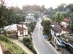
Vairengte
Vairengte | |
|---|---|
Town | |
 Banglaveng, Vairengte | |
| Coordinates: 24°30′00″N 92°45′50″E / 24.500073°N 92.763796°ECoordinates: 24°30′00″N 92°45′50″E / 24.500073°N 92.763796°E | |
| Country | |
| State | Mizoram |
| District | Kolasib |
| Population (2011) | |
| • Total | 10,545 |
| Languages | |
| • Official | Mizo |
| Time zone | UTC+5:30 (IST) |
| Telephone code | +91 (0) 3837 |
Vairengte is a town in the Kolasib district of Mizoram state, India. It is located about 130 kilometres (81 mi) from the state capital, Aizawl.
Administration[edit | edit source]
Vairengte is a sub-divisional headquarters. The main officers within Vairengte are:
- Sub-Divisional Officer (Civil) or SDO (C)
- Sub-Divisional Police Officer (SDPO)
- Sub-Divisional Officer (SDO), PWD, Highway Sub-Division
- Sub-Divisional Officer (SDO), P&E, Power Sub-Division
- Agriculture Extension Officer (AEO)
- Range Officer (RO), Environment & Forest Dept.
Demographics[edit | edit source]
[needs update] As of the 2011 Census of India, The total population in Vairengte city/town is 10,554. There are 5,649 males; There are 4,905 females.[1]
Population of Children with age of 0-6 is 1441 which is 13.65 % of total population of Vairengte. Female Sex Ratio is of 868, which is lower than the Mizoram's state average 976. Moreover Child Sex Ratio is around 1013, which is higher than the state average of 970. Literacy rate of Vairengte city is 94.73 % higher than state average of 91.33 %. Male literacy is around 95.24 % while female literacy rate is 94.14 %.[1]
There are 1,931 House Holds in Vairengte.[1]
Religion[edit | edit source]
As of 2011[update] census, there are 83.51% Christians, 10.44% Hindus, 5.44% Muslims and 0.61% others including Buddhist and Sikhs.[2]
Bank[edit | edit source]
Media[edit | edit source]
The Major Newspaper in Vairengte are Vairengte Aw:[3] [4] and Rengkhawpui.
CIJWS[edit | edit source]
The original plans to set up a counter-insurgency unit to train soldiers came about following the government response to the Mizo militancy in the 1960s. Field Marshal Sam Manekshaw, then the General Officer Commanding-in-Chief (GOC-IN-C) of the Indian Army's Eastern Command, was the first proponent for the institute.[5]
CIJWS was established in 1967 as the Jungle Training School. It was initially located in Mynkre, near Jowal in Jaintia Hills district of Meghalaya. In 1968, the designation was changed to Eastern Command Counter Insurgency Training School. On 1 May 1970, it was upgraded to a Category A Training Establishment of the Indian Army, given its current name and relocated to Vairengte. Brigadier Mathew Thomas was appointed the school's first Commandant.
The crisis in neighbouring East Pakistan and the resulting liberation struggle for Bangladesh prompted a temporary refocus as the Mukti Bahini guerrillas were trained at the institute. Operation Jackpot undertaken by the Mukti Bahini rebels was an instance of the school's training success. Since the Indo-Pakistani War of 1971, CIJWS has focused to its primary role of counter-insurgency training.
CIJWS has hosted visiting military units for training from the United States, Singapore, Nepal, Bhutan, Russia, United Kingdom, Israel, France, Bangladesh and many other nations.
The success of this school prompted the establishment of another counter-insurgency training centre, the Kaziranga Special Jungle Warfare Training School in Assam.[6]
Education[edit | edit source]
- Vairengte Higher Secondary School
- Government Vairengte High School
- Vairengte High School-II Ph- 03837 261 406.
- St Henry School
- Vairengte New Secondary School
- Army School Vairengte
- Government Middle School I
- Government Middle School II
- Government Middle School III
- Upper Primary school, Stateveng
- Upper Primary school, IOC veng
- Presbyterian English School
- ZD English School
- Government Primary School I
- Government Primary School II
- Government Primary School III
- Government Primary School V
- Government Primary School VI
- Government Primary School VII
- Baptist English School
- Counterinsurgency and Jungle Warfare School (CIJWS) is a training and research establishment of the Indian Army specialising in unconventional warfare, especially counter-insurgency and guerrilla warfare. CIJW is one of the premier counter-insurgency training institutions in the world.[6]
Neighbourhoods[edit | edit source]
- Silchar
- Saihapui V
- Phainuam
- N.Chhimluang
- Bhaga Bazar
- Channighat
- Lailapur
Connectivity[edit | edit source]
Vairengte is connected by road, railways and air to the rest of the country. Vairengte is connected by NH 306. The nearest Rail Station is Silchar Rail Station and it is 47.7 km far from Vairengte. The Nearest Airport is Silchar Airport, it is 71.8 km from Vairengte. The Nearest State Capital is Aizawl, a capital of Mizoram, it is 124 km far away from Vairengte.
See also[edit | edit source]
References[edit | edit source]
- ↑ 1.0 1.1 1.2 "Vairengte Population Census 2011". census2011.co.in. Retrieved 4 May 2018.
- ↑ "Kolasib District Religion Census 2011". census2011.co.in. Retrieved 4 May 2018.
- ↑ "Accredited Journalists". DIPR Mizoram. Retrieved 5 September 2012.
- ↑ "RNI Registration".
- ↑ "Back to school..." Rediff.com. 21 February 2000. Retrieved 16 November 2011.
- ↑ 6.0 6.1 "India takes the fight to guerrillas". Asia Times Online. 20 November 2004. Archived from the original on 22 November 2004. Retrieved 16 November 2011.
{{cite news}}: CS1 maint: unfit URL (link)
