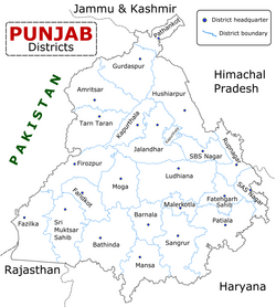
Moga district
This article has multiple issues. Please help improve it or discuss these issues on the talk page. (Learn how and when to remove these template messages)
|
Moga District | |
|---|---|
 Districts of Indian Punjab with headquarters | |
| Country | |
| State | Punjab |
| Headquarters | Moga |
| Area | |
| • Total | 2,235 km2 (863 sq mi) |
| Population (2011) | |
| • Total | 995,746 |
| • Density | 444/km2 (1,150/sq mi) |
| Languages | |
| • Official | Punjabi |
| Time zone | UTC+5:30 (IST) |
| Website | moga |
Moga district is one of the twenty-two districts in the state of Punjab, India. It became the 17th district of Punjab State on 24 November 1995 cut from Faridkot district. Moga District is among the largest producers of wheat and rice in Punjab, India. People from Moga City and Moga District belong to the Malwa culture.
Numerous attempts were previously made to make Moga a district but all were unsuccessful. Finally, the then Chief Minister of Punjab S. Harcharan Singh Brar agreed to the public demand to make Moga a district on 24 November 1995. Before this, Moga was the subdivision of Faridkot district. Moga town is the headquarters of the district, is situated on Ferozpur-Moga-Ludhiana road. Takhtupura Sahib is one of the well-known villages in this district. Takhtupura Sahib is a historical village. Moga is well for Nestle, Adani Food Pvt Ltd, and vehicle modifications. Highways connected with Moga are Jalandhar, Barnala, Ludhiana, Ferozpur, Kotkapura, Amritsar. Bus services and Railway services are well connected with some major cities like Ludhiana, Chandigarh, and Delhi.
Towns[edit]
The towns of Bagha Purana, Badhni Kalan, Dharamkot, Kot Ise Khan, Nihal Singh Wala and Ghal Kalan fall in Moga District. The villages like Khosa Randhir, Dhalleke, Thathi Bhai, Rajiana, Dunne Ke, Landhe Ke, Samadh Bhai, Kotla Rai-ka, Bughipura, Daudhar, Dhudike, Lopon, Himmatpura and Chugawan also fall within this district.
Bagha Purana lies on the main road connecting Moga and Faridkot and thus is a major hub for buses to all across Punjab. Bagha Purana's police station has the largest jurisdiction in Punjab; over 65 'pinds' or villages are within its control. The town is basically divided into 3 'pattis' or sections: Muglu Patti (the biggest one), Bagha Patti, and Purana Patti. The town has its fair share of rich people and thus the standard of living is above average as compared to the surrounding towns and villages.
Dharamkot is a city and a municipal council in the Moga district. Daudhar is the largest village in Moga.
Demographics[edit]
| Year | Pop. | ±% p.a. |
|---|---|---|
| 1951 | 379,181 | — |
| 1961 | 443,135 | +1.57% |
| 1971 | 536,623 | +1.93% |
| 1981 | 655,873 | +2.03% |
| 1991 | 777,894 | +1.72% |
| 2001 | 894,793 | +1.41% |
| 2011 | 995,746 | +1.07% |
| source:[1] | ||
According to the 2011 census Moga district has a population of 995,746,[3] roughly equal to the nation of Fiji[4] or the US state of Montana.[5] This gives it a ranking of 447th in India (out of a total of 640).[3] The district has a population density of 444 inhabitants per square kilometre (1,150/sq mi) .[3] Its population growth rate over the decade 2001-2011 was 10.9%.[3] Moga has a sex ratio of 893 females for every 1000 males,[3] and a literacy rate of 71.6%.[3]
Education[edit]
Moga city is also known for a number of educational institutes such as Engineering Colleges, Schools, etc.
Some of the most famous schools and colleges of Moga City are:
- BMS Institute of Education
- DM College
- Guru Nanak college
- D N Model Senior Secondary School
- Baba Kundan Singh Memorial Law College
- ISF College of Pharmacy [1]/
- Lala Laj Pat Rai Institute Of Engineering & Technology
- Sacred Heart School
- Blooming Buds Senior Secondary school
- Mount Litera Zee School, Moga
- Desh Bhagat Institute of Engineering and Management
- Little Millennium School
- Gold Coast Sports Academy
- National convent senior secondary school
- Adarsh Model High School
- Oxford School
Notable people[edit]
- Narinder Singh Kapany, Indian born American Physicist known for his work in fiber optics
- Jarnail Singh Bhindranwale, militant leader, born in the village of Rode
- Lala Lajpat Rai, an Indian freedom fighter from Village Dhudhike
- Jathedar Tota Singh former Punjab Education Minister and former Agriculture Minister
- Jaswant Singh Kanwal, Sahitya academic fellowship for the book 'Pakhi' 1996 and Sahitya Akademi award for 'Taushali Di Hanso' 1998. He was from Dhudike vill.
- Lachhman Singh Gill, Chief Minister of Punjab from Village Chuhar Chak
- Sonu Sood, Indian Film Actor
- Roshan Prince, Actor and Singer
- Harmanpreet Kaur, Batswoman in the Indian Women's National Cricket Team and Captain of the T20 Indian Women's National Cricket Team
- Subedar Joginder Singh, was an Indian Army soldier, and recipient of the Param Vir Chakra.
- Baldev Singh, author, winner of the Sahitya Akademi Award
See also[edit]
References[edit]
- ↑ Decadal Variation In Population Since 1901
- ↑ "Moga District Population Census 2011-2021, Punjab literacy sex ratio and density".
- ↑ 3.0 3.1 3.2 3.3 3.4 3.5 "District Census 2011". Census2011.co.in. 2011. Retrieved 30 September 2011.
- ↑ US Directorate of Intelligence. "Country Comparison:Population". Retrieved 1 October 2011.
Fiji 883,125 July 2011 est.
- ↑ "2010 Resident Population Data". U. S. Census Bureau. Retrieved 30 September 2011.
Montana 989,415
External links[edit]
Coordinates: 30°49′12″N 75°10′12″E / 30.82000°N 75.17000°E

