Coorg State
| Coorg State | |||||||||
|---|---|---|---|---|---|---|---|---|---|
| State of India | |||||||||
| 1947–1956 | |||||||||
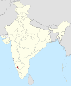
 Location of Coorg in India | |||||||||
| History | |||||||||
| Government | |||||||||
| Chief Minister | |||||||||
• 1950-1956 | C. M. Poonacha | ||||||||
| History | |||||||||
• Coorg State formed from Coorg Province | 26 January 1947 | ||||||||
• Merged into Mysore State | 1 November 1956 | ||||||||
| |||||||||
| States of India since 1947 | |||||||||
| Culture of Karnataka |
|---|
 |
Coorg State was a Part-C state in India which existed from 1950 to 1956.[1] When the Constitution of India came into force on 26 January 1950, most of the existing provinces were reconstituted into states. Thus, Coorg Province became Coorg State. Coorg State was ruled by a Chief Commissioner with Mercara as its capital. The head of the government was the Chief Minister. Coorg State was abolished on 1 November 1956 as per the States Reorganisation Act, 1956 and its territory were merged with Mysore State (later renamed as Karnataka in 1973).[2] Presently, Coorg forms a district of Karnataka state.
History[edit | edit source]
The Coorg State came into being on 26 January 1950 as per the Constitution of India. Prior to the enactment of the Constitution, Coorg had been a province of the Dominion of India.
The first legislative elections in Coorg were held in 1952. The main contenders were the Indian National Congress led in the state by C. M. Poonacha and the Takkadi party led by the Gandhian Pandyanda Belliappa. While the Congress supported merger with the neighbouring Mysore State, the Takkadi party fought the election on an anti-merger plank. The Indian National Congress won a majority of 15 seats while the Takkadi party bagged the remaining nine seats.
Commissioners of Coorg State[edit | edit source]
(1) Dewan Bahadur Ketolira Chengappa, became its first Chief Commissioner from 1947–1949
(2) C.T. Mudaliar became Chief Commissioner from 1949 - 1950[1]
(3) Kanwar Baba Daya Singh Bedi, Chief Commissioner from 1950 - 1956[1]
Government of Coorg[edit | edit source]
Government was formed in Coorg by Indian National Congress, who won 15 of 24 seats. Cabinet was formed with two ministers (including Chief Minister), which lasted till States Reorganisation Act on 1 November 1956.
Chief Minister[edit | edit source]
Cheppudira Muthana Poonacha won from Berriathnad constituency became the first and last Chief Minister of Coorg State from 1950 till 1956.[1]
Cabinet[edit | edit source]
- Cheppudira Muthana Poonacha, who was the Chief Minister took the charge of Ministry of Finance for Coorg State.
- Kuttur Mallapa (elected to the assembly from the Sanivarsanthe constituency became the Home Minister of Coorg State
Dissolution[edit | edit source]
As a result of the States Reorganisation Act of 1 November 1956, when India's state boundaries were reorganised, Coorg State became a district of the then Mysore State[1][3][4] Mysore State was later renamed as Karnataka and part of the historical region of Coorg now forms the Kodagu district of Karnataka.[5]
See also[edit | edit source]
References[edit | edit source]
- ↑ 1.0 1.1 1.2 1.3 1.4 Cahoon, Ben. "Indian states since 1947". www.worldstatesmen.org.
- ↑ "When Kodagu merged with Mysore: A short political history of the region".
- ↑ Gayathri, M. B.; Mysore, University of (6 April 1997). "Development of Mysore state, 1940-56". University of Mysore – via Google Books.
- ↑ Ramaswamy, Harish (6 April 2018). Karnataka Government and Politics. Concept Publishing Company. ISBN 9788180693977 – via Google Books.
- ↑ Muthanna, I M. Coorg Memoirs (The story of the Kodavas).
Further reading[edit | edit source]
- Government of Coorg (1953), Handbook of Coorg Census-1951 (PDF), Assistant Commissioner and District Census Officer, Coorg
