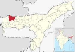
Chirang district
Chirang | |
|---|---|
 Dwijing Festival in Chirang | |
 | |
| Coordinates (Kajalgaon): 26°35′N 90°37′E / 26.58°N 90.61°ECoordinates: 26°35′N 90°37′E / 26.58°N 90.61°E | |
| Country | |
| State | |
| Territorial Region | |
| Headquarters | Kajalgaon |
| Government | |
| • Lok Sabha constituencies | Kokrajhar (shared with Kokrajhar district) |
| • Vidhan Sabha constituencies | Sidli, Bijni |
| Area | |
| • Total | 1,169.9 km2 (451.7 sq mi) |
| Population (2001) | |
| • Total | 482,162 |
| • Density | 410/km2 (1,100/sq mi) |
| Time zone | UTC+05:30 (IST) |
| Major highways | 31C |
| Website | chirang |
Chirang District is an administrative district in the Bodoland Territorial Region of Assam state in the North-East of India.
History[edit]
It is a relatively new district in the Bodoland Territorial Region of Assam. Chirang district has been carved out from Bongaigaon district in 2004.[1] The word "Chirang" has derived from Garo word -"Chi" means Water and "Rang" means Rain. It may also be a copy of Tsirang District of neighbouring Bhutan. On the other hand, Most of the people regarded the word Chirang is derived from the Bodo word Chirang or Sirang. Si means life and Rang means Money. Sirang was an area which is covered by valuable soil, plants, trees, flora and fauna or the things which are necessary for human life. Thus it is a place which is important for human life or the place which is just like money or valuable for life and is later come to know Si + Rang = sirang. After some time the word articulated to Chirang from Sirang. And thus the word Sirang is latter known as Chirang.
Geography[edit]
National protected area[edit]
- Manas National Park (Part) - protected area.
Flora and fauna[edit]
In 1990 Chirang district became home to Manas National Park, which has an area of 500 km2 (193.1 sq mi).[2] It shares the park with four other districts.
Demographics[edit]
According to the 2011 census Chirang district has a population of 482,162,[3] roughly equal to the nation of Suriname.[4] This gives it a ranking of 547th in India (out of a total of 640).[3] The district has a population density of 244 inhabitants per square kilometre (630/sq mi) .[3] Its population growth rate over the decade 2001-2011 was 11.26%.[3] Chirang has a sex ratio of 969 females for every 1000 males,[3] and a literacy rate of 64.71%. Scheduled Castes and Scheduled Tribes made up 7.29% and 37.06% of the population respectively.[3]
| Year | Pop. | ±% p.a. |
|---|---|---|
| 1901 | 37,523 | — |
| 1911 | 48,731 | +2.65% |
| 1921 | 61,885 | +2.42% |
| 1931 | 71,977 | +1.52% |
| 1941 | 82,972 | +1.43% |
| 1951 | 90,797 | +0.91% |
| 1961 | 165,829 | +6.21% |
| 1971 | 247,085 | +4.07% |
| 1991 | 437,288 | +2.90% |
| 2001 | 433,061 | −0.10% |
| 2011 | 482,162 | +1.08% |
| source:[5] | ||
Religion[edit]
Hindus make up the majority, with 66.50%. Muslims are the second-largest with 22.66%. Christians are third with 10.32%.
Language[edit]
According to the 2011 census, 37.83% of the population spoke Boro, 28.86% Bengali, 17.66% Assamese, 4.73% Santali, 4.22% Rajbongshi, 2.51% Nepali, 1.11% Kurukh and 1.06% Hindi as their first language.[7]
References[edit]
- ↑ Law, Gwillim (25 September 2011). "Districts of India". Statoids. Retrieved 11 October 2011.
- ↑ Indian Ministry of Forests and Environment. "Protected areas: Assam". Archived from the original on 23 August 2011. Retrieved 25 September 2011.
- ↑ 3.0 3.1 3.2 3.3 3.4 3.5 "District Census 2011". Census2011.co.in. 2011. Retrieved 30 September 2011.
- ↑ US Directorate of Intelligence. "Country Comparison:Population". Retrieved 1 October 2011.
Suriname 491,989 July 2011 est.
- ↑ Decadal Variation In Population Since 1901
- ↑ District Report - CHIRANG Archived 29 March 2017 at the Wayback Machine Ministry of Minority Affairs, Govt of India
- ↑ "C-16 Population By Mother Tongue - Assam". censusindia.gov.in. Retrieved 12 April 2020.
External links[edit]