







Ajay Kumar (talk | contribs) Created a new article Tag: Disambiguation links |
DebraToney89 (talk | contribs) rework citations per sources |
||
| Line 1: | Line 1: | ||
{{About|the | {{About|the town in India|its namesake district|Dhubri district}} | ||
{{Use dmy dates|date=June 2018}} | {{Use dmy dates|date=June 2018}} | ||
{{Use Indian English|date=June 2018}} | {{Use Indian English|date=June 2018}} | ||
<!-- See [[Wikipedia:WikiProject Indian cities]] for details -->{{Infobox settlement | <!-- See [[Wikipedia:WikiProject Indian cities]] for details -->{{Infobox settlement | ||
| name | | name = Dhubri | ||
| native_name | | native_name = | ||
| native_name_lang | | native_name_lang = as | ||
| other_name | | other_name = | ||
| settlement_type | | settlement_type = City | ||
| translit_lang1_info | | translit_lang1_info = | ||
| image_skyline | | image_skyline = | ||
{{multiple image | |||
| border = infobox | |||
| total_width = 299 | |||
| image_style = | |||
| perrow = 1/2/2/2/1/1 | |||
| image1 = Dhubri Aerial View.jpg | |||
| caption1 = Dhubri City Aerial View | |||
| image2 = Dhubri City Street View.jpg | |||
| caption2 = | |||
| image3 = Guru Dwara Dhubri.jpg| | |||
| caption3 = Tegh Bahadur Gurudwara | |||
| | | image4 = Building of DC Court Dhubri.jpg|thumb|Dhubri District Court New Building | ||
| | | caption4 = District Court | ||
| | | image5 = Dhubri Harishaba Area In 2024.jpg | ||
| | | caption5 = Harishaba Area | ||
| | | image6 = Harishaba area night view in 2024.jpg | ||
| | | caption6 = Harishaba Area At Night | ||
| | | image7 = Academic Building of Dhubri Medical college & Hospital.jpg | ||
| | |caption7 = DMCH Academic Building | ||
| | | image8 = Dhubri City Skyline 2.jpg | ||
| | | caption8 = Dhubri Administrative Area | ||
| | | image9 = Dhubri Chowk Bazar Area.jpg | ||
| | | caption9 = Dhubri Chowk Bazar Area | ||
| | |||
| | |||
| | |||
| | |||
| | |||
| | |||
| | |||
| | |||
| | |||
| | |||
| | |||
| | |||
}} | }} | ||
'''Dhubri''' | | image_flag = | ||
| flag_border = | |||
| image_seal = | |||
| nicknames = Land of Rivers & Jute Hub Of Assam | |||
| pushpin_map = India Assam | |||
| pushpin_label_position = | |||
| pushpin_map_alt = | |||
| pushpin_map_caption = Location in Assam | |||
| coordinates = {{coord|26.02|N|90|E|display=inline,title}} | |||
| subdivision_type = Country | |||
| subdivision_name = {{flag|India}} | |||
| subdivision_type1 = State | |||
| subdivision_type2 = District | |||
| subdivision_type5 = [[Regions of India|Region]] | |||
| subdivision_name1 = [[Assam]] | |||
| subdivision_name2 = [[Dhubri district|Dhubri]] | |||
| subdivision_name5 = [[Lower Assam]] | |||
| established_title = Established | |||
| established_date = 1883 | |||
| founder = | |||
| named_for = | |||
| government_type = Municipality | |||
| governing_body = Dhubri Municipal Board | |||
| leader_title = Chairman | |||
| leader_name = [[Debomoy Sanyal|Dr. Debamoy Sanyal]] ([[Bharatiya Janata Party|BJP]])<ref>{{cite news|url=https://www.indiatodayne.in/assam/video/dhubris-historic-ashokastami-mela-in-assam-enters-56th-year-as-symbol-of-communal-unity-1365368-2026-03-25|title=Dhubri’s historic Ashokastami mela in Assam enters 56th year as symbol of communal unity|author=Mehtab Uddin Ahmed|date=25 March 2026|newspaper=[[India Today|India Today NE]]|accessdate=28 March 2026|archive-date=26 March 2026|archive-url=https://web.archive.org/web/20260326173501/https://www.indiatodayne.in/assam/video/dhubris-historic-ashokastami-mela-in-assam-enters-56th-year-as-symbol-of-communal-unity-1365368-2026-03-25|url-status=live}}</ref> | |||
| leader_title1 = Vice Chairman | |||
| leader_name1 = Ivy Lata Roy ([[Bharatiya Janata Party|BJP]])<ref>{{cite news|url=https://www.sentinelassam.com/north-east-india-news/assam-news/newly-elected-chairman-vice-chairperson-of-dhubri-municipal-board-take-oath-586589|title=Newly-elected chairman, vice-chairperson of Dhubri Municipal Board take oath|date=8 April 2022|newspaper=[[The Sentinel (Guwahati)]]|accessdate=28 March 2026|archive-date=8 April 2022|archive-url=https://web.archive.org/web/20220408074439/https://www.sentinelassam.com/north-east-india-news/assam-news/newly-elected-chairman-vice-chairperson-of-dhubri-municipal-board-take-oath-586589|url-status=live}}</ref> | |||
| leader_title2 = Deputy Commissioner | |||
| leader_name2 = Sri Dibakar Nath, [[Indian Administrative Service|IAS]] | |||
| leader_title3 = Superintendent Of Police | |||
| leader_name3 = Ms. Aparna N, [[Indian Police Service|IPS]] | |||
| unit_pref = Metric | |||
| area_total_km2 = 32 | |||
| area_water_km2 = 4.9 | |||
| area_water_sq_mi = | |||
| area_rank = 8th in Assam | |||
| elevation_footnotes = | |||
| elevation_m = | |||
| population_total = 155000 | |||
| population_as_of = 2025 | |||
| population_footnotes = | |||
| population_density_km2 = 6300 | |||
| population_metro = | |||
| population_rank = 10th in Assam | |||
| population_demonym = Dhubrian | |||
| timezone1 = [[Indian Standard Time|IST]] | |||
| utc_offset1 = +5:30 | |||
| postal_code_type = [[Postal Index Number|PIN]] | |||
| postal_code = 783301 | |||
| registration_plate = AS-17 | |||
| website = https://dhubri.assam.gov.in/ | |||
| iso_code = [[ISO 3166-2:IN|IN-AS]] | |||
| blank1_name_sec1 = [[Human sex ratio|Sex Ratio]] | |||
| blank1_info_sec1 = 953 [[Female|♀️]]/ 1000 [[Male|♂️]] | |||
| blank2_name_sec1 = [[Köppen climate classification|Climate]] | |||
| blank2_info_sec1 = [[Humid subtropical climate|Cwa]] | |||
| blank3_name_sec1 = {{nowrap|[[Official Language]]}} | |||
| blank3_info_sec1 = [[Assamese language|Assamese]]<ref>{{Cite web|url=https://www.ndtv.com/india-news/assam-assembly-accords-associate-official-language-status-to-bodo-2345750 |title=Assam assembly accords associate official language status to bodo|date=30 December 2020|website=NDTV}}</ref> | |||
| blank4_name_sec1 = Most spoken language | |||
| blank4_info_sec1 = [[Bengali language|Bengali]] | |||
| blank1_name_sec2 = [[Literacy in India|Literacy Rate]] | |||
| blank1_info_sec2 = {{Increase}} 89.34% {{colour|#fc5|High}} | |||
| blank2_name_sec2 = [[Lok Sabha]] Constituency | |||
| blank2_info_sec2 = [[Dhubri Lok Sabha constituency|Dhubri]] | |||
| blank3_name_sec2 = [[Vidhan Sabha]] Constituency | |||
| blank3_info_sec2 = [[Dhubri Assembly constituency|Dhubri]] | |||
| official_name = Dhubri City | |||
}} | |||
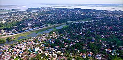
'''Dhubri''' is a city and the administrative centre of [[Dhubri district]] in the Indian state of [[Assam]]. It is an old town on the bank of the [[Brahmaputra River|Brahmaputra]] River, with historical significance. In 1883, the town was first constituted as a municipal board under the British regime. It is situated about {{convert|277.4|km|mi|0}} west from [[Dispur]], the state capital of Assam. | |||
The town is also an important commercial centre and had a busy river port particularly for [[jute]]. Dhubri is called the "Land of Rivers" as it is covered three sides by Brahmaputra and | The town is also an important commercial centre and had a busy river port, particularly for [[jute]]. Dhubri is called the "Land of Rivers" as it is covered on three sides by the Brahmaputra and Gangadhar rivers.<ref>{{cite news |url=https://www.telegraphindia.com/1071013/asp/northeast/story_8429802.asp |archive-url=https://web.archive.org/web/20071110011939/http://www.telegraphindia.com/1071013/asp/northeast/story_8429802.asp |url-status=dead |archive-date=10 November 2007 |title=Priceless heritage gets funds to survive |newspaper=The Telegraph |location=Calcutta |date=13 October 2007 |access-date=10 June 2018}}</ref> | ||
== History == | == History == | ||
{{unreferenced section|date=October 2023}} | |||
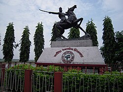
[[File:Chilarai Dhubri.JPG|200px|left|thumb|[[Chilarai]] Statue at Dhubri]] | [[File:Chilarai Dhubri.JPG|200px|left|thumb|[[Chilarai]] Statue at Dhubri]] | ||
Until 1874, Dhubri was mostly | Until 1874, Dhubri was mostly ruled by [[Koch dynasty|Koch Kings]]. In 1874, the [[British Raj|British government]] created a new province named [[Assam Province|Assam Valley Province]] and incorporated Goalpara district area comprising three civil subdivisions Dhubri, Goalpara and Kokrajhar with the new Assam Province. In 1879, the district headquarters was shifted from [[Goalpara]] to Dhubri city. The district of Dhubri is again subdivided in three districts namely Dhubri, Goalpara and Kokrajhar. The City of Dhubri falls under the jurisdiction of the district of Dhubri whose headquarters is at city Dhubri. | ||
The present Dhubri District is one of the three Civil Sub-divisions of erst-while Goalpara district, established in 1876 during British regime. In 1879 the District headquarters was shifted from Goalpara to Dhubri. | The present Dhubri District is one of the three Civil Sub-divisions of erst-while Goalpara district, established in 1876 during British regime. In 1879 the District headquarters was shifted from Goalpara to Dhubri. | ||
In | In 1983 Goalpara district was divided into four separate districts and Dhubri is one of those. Covering an area of 2,838 km<sup>2</sup>. including forests, riverines, hills etc. the district has become the most densely populated district in India with a density of 584 persons per km<sup>2</sup>.(As per 2001 census). | ||
The Dhubri city was first constituted as a Municipality in 1883. The Dhubri city is 290 km far from the State Capital at [[Dispur]]. | The Dhubri city was first constituted as a Municipality in 1883. The Dhubri city is 290 km far from the State Capital at [[Dispur]]. | ||
| Line 106: | Line 122: | ||
|thumb = right | |thumb = right | ||
|caption = Religion in Dhubri Town (2011)<ref>{{cite web |title=C-1 Population By Religious Community |url=https://censusindia.gov.in/2011census/C-01/DDW18C-01%20MDDS.XLS |website=censusindia.gov.in |access-date=26 January 2021}}</ref> | |caption = Religion in Dhubri Town (2011)<ref>{{cite web |title=C-1 Population By Religious Community |url=https://censusindia.gov.in/2011census/C-01/DDW18C-01%20MDDS.XLS |website=censusindia.gov.in |access-date=26 January 2021}}</ref> | ||
|label1 = [[ | |label1 = [[Hinduism]] | ||
|value1 = | |value1 = 64.76 | ||
|color1 = | |color1 = DarkOrange | ||
|label2 = [[ | |label2 = [[Islam]] | ||
|value2 = | |value2 = 33.48 | ||
|color2 = | |color2 = Green | ||
|label3 = [[Christianity]] | |label3 = [[Christianity]] | ||
|value3 = | |value3 = 0.21 | ||
|color3 = Blue | |color3 = Blue | ||
|label4 = others | |label4 = others | ||
|value4 = | |value4 = 1.55 | ||
|color4 = yellow}} | |color4 = yellow}} | ||
{{As of|2011}} India [[census]],<ref>{{cite web |url=http://www.censusindia.net/results/town.php?stad=A&state5=999 |archive-url=https://web.archive.org/web/20040616075334/http://www.censusindia.net/results/town.php?stad=A&state5=999 |archive-date=2004-06-16 |title=Census of India 2001: Data from the 2001 Census, including cities, villages and towns (Provisional) |access-date=2008-11-01 |publisher=Census Commission of India}}</ref> Dhubri had a population 63,388 and Dhubri - Gauripur Metropolitan area had a Population | {{As of|2011}} India [[census]],<ref>{{cite web |url=http://www.censusindia.net/results/town.php?stad=A&state5=999 |archive-url=https://web.archive.org/web/20040616075334/http://www.censusindia.net/results/town.php?stad=A&state5=999 |archive-date=2004-06-16 |title=Census of India 2001: Data from the 2001 Census, including cities, villages and towns (Provisional) |access-date=2008-11-01 |publisher=Census Commission of India}}</ref> Dhubri had a population 63,388 and Dhubri - Gauripur Metropolitan area had a Population 1,22,400. Males constitute 51% of the population and females 49%. Dhubri has an average literacy rate of 74%, higher than the national average of 59.5%: male literacy is 79% and, female literacy is 68%. In Dhubri, 11% of the population is under 6 years of age. With close to 75% of its population Muslims, it is one of the minority concentrated districts of India. | ||
{{Pie chart | {{Pie chart | ||
| Line 143: | Line 159: | ||
|color6 = pink | |color6 = pink | ||
}} | }} | ||
Most of these people are [[Bengali Hindus]] | Most of these people are [[Bengali Hindus]], [[Bengali Muslims]], [[Deshi people|Deshi Muslims]], [[Koch people|Koch Rajbongshi Hindus]]. [[Assamese language|Assamese]], [[Goalpariya dialects|Goalpariya]] and [[Bengali language|Bengali]] are the major languages spoken in the town. | ||
== Geography and climate == | == Geography and climate == | ||
Dhubri lies at 89.5 degree east longitude and 26.1 degree north latitude, and about {{convert|34|m|ft|-1|disp=or}} above sea level. Dhubri is covered by rivers on three sides, predominated by | Dhubri lies at 89.5 degree east longitude and 26.1 degree north latitude, and about {{convert|34|m|ft|-1|disp=or}} above sea level. Dhubri is covered by rivers on three sides, predominated by mighty Brahmaputra River. | ||
As is typical for [[Assam]] and Tripura, Dhubri has a monsoon-influenced [[humid subtropical climate]] ([[Köppen climate classification|Köppen]] ''Cwa''), being a little too cool to qualify as a [[tropical monsoon climate]]. The "cool" or winter season from November to February is warm to very warm during the afternoon, and pleasantly cool in the morning. The "hot" season of March and April is indeed hot and sees increasing humidity and rain, leading into the oppressively humid and extremely wet [[Monsoon of South Asia|monsoon]] season from May to the middle of October. | As is typical for [[Assam]] and Tripura, Dhubri has a monsoon-influenced [[humid subtropical climate]] ([[Köppen climate classification|Köppen]] ''Cwa''), being a little too cool to qualify as a [[tropical monsoon climate]]. The "cool" or winter season from November to February is warm to very warm during the afternoon, and pleasantly cool in the morning. The "hot" season of March and April is indeed hot and sees increasing humidity and rain, leading into the oppressively humid and extremely wet [[Monsoon of South Asia|monsoon]] season from May to the middle of October. | ||
{{Weather box | {{Weather box | ||
| location = Dhubri ( | | location = Dhubri (1991–2020, extremes–2020) | ||
| metric first = Yes | | metric first = Yes | ||
| single line = Yes | | single line = Yes | ||
| Jan record high C = 29. | | Jan record high C = 29.9 | ||
| Feb record high C = | | Feb record high C = 32.1 | ||
| Mar record high C = | | Mar record high C = 37.5 | ||
| Apr record high C = | | Apr record high C = 39.6 | ||
| May record high C = | | May record high C = 38.0 | ||
| Jun record high C = | | Jun record high C = 38.7 | ||
| Jul record high C = | | Jul record high C = 36.7 | ||
| Aug record high C = 36. | | Aug record high C = 36.8 | ||
| Sep record high C = 35. | | Sep record high C = 35.5 | ||
| Oct record high C = | | Oct record high C = 34.3 | ||
| Nov record high C = | | Nov record high C = 30.6 | ||
| Dec record high C = | | Dec record high C = 27.1 | ||
| year record high C = | | year record high C = 39.6 | ||
| Jan high C = | | Jan high C = 21.4 | ||
| Feb high C = | | Feb high C = 25.3 | ||
| Mar high C = | | Mar high C = 29.6 | ||
| Apr high C = | | Apr high C = 30.0 | ||
| May high C = 30. | | May high C = 30.5 | ||
| Jun high C = 31. | | Jun high C = 31.1 | ||
| Jul high C = 31.1 | | Jul high C = 31.1 | ||
| Aug high C = 31.9 | | Aug high C = 31.9 | ||
| Sep high C = 30. | | Sep high C = 30.9 | ||
| Oct high C = | | Oct high C = 29.1 | ||
| Nov high C = | | Nov high C = 26.2 | ||
| Dec high C = | | Dec high C = 22.9 | ||
| year high C = 29. | | year high C = 28.3 | ||
| Jan low C = | |Jan mean C = 17.1 | ||
| Feb low C = | |Feb mean C = 20.4 | ||
| Mar low C = | |Mar mean C = 24.5 | ||
| Apr low C = | |Apr mean C = 26.2 | ||
| May low C = | |May mean C = 27.2 | ||
| Jun low C = | |Jun mean C = 28.3 | ||
| Jul low C = | |Jul mean C = 29.0 | ||
| Aug low C = | |Aug mean C = 29.4 | ||
| Sep low C = | |Sep mean C = 28.4 | ||
| Oct low C = | |Oct mean C = 26.6 | ||
| Nov low C = | |Nov mean C = 22.6 | ||
| Dec low C = | |Dec mean C = 18.8 | ||
| year low C = | | Jan low C = 12.5 | ||
| Jan record low C = | | Feb low C = 15.4 | ||
| Feb record low C = 3 | | Mar low C = 19.0 | ||
| Mar record low C = | | Apr low C = 21.7 | ||
| Apr record low C = | | May low C = 23.5 | ||
| May record low C = | | Jun low C = 25.4 | ||
| Jun record low C = | | Jul low C = 26.3 | ||
| Jul record low C = | | Aug low C = 26.6 | ||
| Aug record low C = | | Sep low C = 25.9 | ||
| Sep record low C = 19. | | Oct low C = 23.5 | ||
| Oct record low C = | | Nov low C = 18.8 | ||
| Nov record low C = | | Dec low C = 14.7 | ||
| Dec record low C = | | year low C = 21.1 | ||
| year record low C = | | Jan record low C = 5.8 | ||
| Feb record low C = 7.3 | |||
| Mar record low C = 11.4 | |||
| Apr record low C = 9.4 | |||
| May record low C = 17.5 | |||
| Jun record low C = 18.7 | |||
| Jul record low C = 20.8 | |||
| Aug record low C = 22.0 | |||
| Sep record low C = 19.4 | |||
| Oct record low C = 18.1 | |||
| Nov record low C = 11.9 | |||
| Dec record low C = 8.1 | |||
| year record low C = 5.8 | |||
| rain colour = green | | rain colour = green | ||
| Jan rain mm = | | Jan rain mm = 7.7 | ||
| Feb rain mm = | | Feb rain mm = 11.4 | ||
| Mar rain mm = | | Mar rain mm = 65.6 | ||
| Apr rain mm = | | Apr rain mm = 198.4 | ||
| May rain mm = | | May rain mm = 351.7 | ||
| Jun rain mm = | | Jun rain mm = 566.2 | ||
| Jul rain mm = | | Jul rain mm = 359.5 | ||
| Aug rain mm = | | Aug rain mm = 292.5 | ||
| Sep rain mm = | | Sep rain mm = 294.6 | ||
| Oct rain mm = | | Oct rain mm = 156.9 | ||
| Nov rain mm = | | Nov rain mm = 3.5 | ||
| Dec rain mm = | | Dec rain mm = 1.6 | ||
|year rain mm = | |year rain mm = 2309.6 | ||
| Jan rain days = 0. | | Jan rain days = 0.8 | ||
| Feb rain days = 2 | | Feb rain days = 1.2 | ||
| Mar rain days = | | Mar rain days = 3.5 | ||
| Apr rain days = 9. | | Apr rain days = 9.7 | ||
| May rain days = | | May rain days = 15.1 | ||
| Jun rain days = | | Jun rain days = 17.5 | ||
| Jul rain days = | | Jul rain days = 14.7 | ||
| Aug rain days = | | Aug rain days = 11.3 | ||
| Sep rain days = | | Sep rain days = 10.9 | ||
| Oct rain days = 5. | | Oct rain days = 5.1 | ||
| Nov rain days = 0. | | Nov rain days = 0.4 | ||
| Dec rain days = 0. | | Dec rain days = 0.3 | ||
|year rain days = | |year rain days = 90.3 | ||
|time day = 17:30 [[Indian Standard Time|IST]] | |time day = 17:30 [[Indian Standard Time|IST]] | ||
| Jan humidity = | | Jan humidity = 74 | ||
| Feb humidity = | | Feb humidity = 65 | ||
| Mar humidity = | | Mar humidity = 59 | ||
| Apr humidity = | | Apr humidity = 72 | ||
| May humidity = | | May humidity = 79 | ||
| Jun humidity = | | Jun humidity = 84 | ||
| Jul humidity = | | Jul humidity = 86 | ||
| Aug humidity = | | Aug humidity = 84 | ||
| Sep humidity = | | Sep humidity = 86 | ||
| Oct humidity = | | Oct humidity = 82 | ||
| Nov humidity = | | Nov humidity = 77 | ||
| Dec humidity = | | Dec humidity = 76 | ||
|year humidity = | |year humidity = 84 | ||
| source 1 = [[India Meteorological Department]]<ref name= | | source 1 = [[India Meteorological Department]]<ref>{{cite web | ||
| url = https://imdpune.gov.in/library/public/Climatological%20Tables%201991-2020.pdf | |||
| title = Climatological Tables of Observatories in India 1991-2020 | |||
| publisher = [[India Meteorological Department]] | |||
| access-date = April 8, 2024 | |||
}}</ref> | |||
|source 2 = Tokyo Climate Center (mean temperatures 1991–2020)<ref name=TCC1> | |||
{{cite web | {{cite web | ||
| | | url = https://ds.data.jma.go.jp/gmd/tcc/tcc/products/climate/normal/parts/NrmMonth_e.php?stn=42404 | ||
| title = Normals Data: Dhubri – India Latitude: 26.02°N Longitude: 89.98°E Height: 35 (m) | |||
| publisher = Japan Meteorological Agency | |||
| title = | | access-date = 1 December 2022}}</ref> | ||
| publisher = | |||
| access-date = | |||
}} | }} | ||
== | == Colleges == | ||
[[File:Ghate of Bholanath College, Dhubri.jpg|thumb|Bholanath College, Dhubri]] | |||
[[File:Bholanath College, Dhubri drone view 1.jpg|thumb|Bholanath College, Dhubri drone view]] | |||
[[File: | [[File:Academic Building of Dhubri Medical college & Hospital.jpg|thumb|Academic Building of Dhubri Medical college & Hospital]] | ||
[[File:CATS Lab.jpg|thumbnail|CATS Dhubri | [[File:CATS Lab.jpg|thumbnail|College of Advanced Technical Studies (CATS Dhubri)]] | ||
* [[Bholanath College]] or | Local colleges include | ||
<!---♦♦♦ Only add a college to this list if it already has its own article on the English Wikipedia ♦♦♦---> | |||
* [[Bholanath College|Bhola Nath College]] or "B. N. College"' (established in 1946), the oldest college in western Assam. | |||
* [[Dhubri Law College]] | * [[Dhubri Law College]] | ||
* [[Dhubri Girls' College]] | * [[Dhubri Girls' College]] | ||
* [[Dhubri Medical College and Hospital]] | |||
* [[Dhubri Medical College | |||
* [[Pramathesh Barua]] College, Gauripur | * [[Pramathesh Barua]] College, Gauripur | ||
* [[Chilarai College]] | * [[Chilarai College]] | ||
* Dhubri PGTT College | |||
* Dhubri College | |||
* [[Jamia Millia Islamia]] University Open & Distance Learning Centre | * [[Jamia Millia Islamia]] University Open & Distance Learning Centre | ||
* | * Ajmal Super 40 (Dhubri) | ||
* | * College of Advanced Technical Studies | ||
== Transportation == | == Transportation == | ||
=== Airport === | === Airport === | ||
[[Rupsi Airport]] at Kokrajhar district is the nearest airport which is about 15 km from the main city and 5 km away from Gauripur. It was constructed during [[World War II]] by the British mainly for military purpose to accommodate 52 jet airplanes. Until 1983, the [[Indian Airlines]] and some private commercial flights operated regularly between Calcutta, [[Guwahati]] and Dhubri. The airport started its commercial service after 38 years in 2021, and the airport is operational with connectivity to [[Kolkata]] and state capital Guwahati. [[FlyBig|Flybig]] operates flights by ATR aircraft under RCS [[UDAN]]. | [[File:Rupsi airport, Assam, India.jpg|thumb|This image shows Rupsi airport, Assam, India]] | ||
[[Rupsi Airport]] at Kokrajhar district is the nearest airport which is only about 15 km from the Dhubri main city and 5 km away from Gauripur town. It was constructed during [[World War II]] by the British mainly for military purpose to accommodate 52 jet airplanes. Until 1983, the [[Indian Airlines]] and some private commercial flights operated regularly between Calcutta, [[Guwahati]] and [[Dhubri]]. The airport started its commercial service after 38 years in 2021, and the airport is operational with connectivity to [[Kolkata]] and state capital Guwahati. [[FlyBig|Flybig]] operates flights by ATR aircraft under RCS [[UDAN]]. | |||
===Railway=== | ===Railway=== | ||
[[File:Dhubri railway station platform with child and flag.jpg|thumb|A child walking on the platform of Dhubri railway station (Indian train station in Assam) in late afternoon, with a large Indian flag flying in the background.]] | |||
[[Dhubri railway station]] serves the town of Dhubri. The station lies on New Cooch Behar-Golokganj branch line and [[Fakiragram–Dhubri branch line]] of [[Northeast Frontier Railway]], [[Alipurduar railway division]]. | [[Dhubri railway station]] serves the town of Dhubri. The station lies on New Cooch Behar-Golokganj branch line and [[Fakiragram–Dhubri branch line]] of [[Northeast Frontier Railway]], [[Alipurduar railway division]]. | ||
| Line 349: | Line 324: | ||
== Tourism == | == Tourism == | ||
Dhubri District | Dhubri District has a number of tourist sites, including the banks of river Brahmaputra with its green fields, blue hills and hillock. The Gurdwara Tegh Bahadur Shaibji, the Rangamati Mosque, [[Mahamaya Dham]], [[Chakrashila Wildlife Sanctuary|Chakrasila wildlife sanctuary]], Matiabagh Hawa Mahal, Satrashal Dham, Panch Peer Dargaha, and other royal palaces attract the people for their unique structures, religious sanctity and mythological importance.{{citation needed|date=December 2024}} | ||
Dhubri is the location of the [[Sikh Gurdwara]] [[Gurdwara Sri Guru Tegh Bahadur Sahib|Gurdwara Damdama Sahib]] or [[Gurdwara Sri Guru Tegh Bahadur Sahib|Thara Sahib]]. | |||
=== Places of interest === | === Places of interest === | ||
* '''[[Mahamaya Dham]] and shakti pith Snan Ghat:-''' of Bogribari, about 30–35 km east from Dhubri town is next to Kamakhya (Guwahati) and Madan-Mohan (Cooch Behar) | [[File:Dhubri Gurdwara1.JPG|thumb|right|200px|Gurdwara Sri Guru Tegh Bahadur Sahib at Dhubri]] | ||
* '''Gurdwara Sri [[Guru Tegh Bahadur|Guru Tegbahadur]] Sahibji''': In the | [[File:Dhubri Gurdawa2.JPG|thumb|right|200px|Gurdwara Sri Guru Tegh Bahadur Sahib Complex]] | ||
* '''[[Mahamaya Dham]] and shakti pith Snan Ghat:-''' of Bogribari, about 30–35 km east from Dhubri town is next to Kamakhya (Guwahati) and Madan-Mohan (Cooch Behar). Originally the mother Goddess Mahamaya of Parvatjowar was worshipped by the local people like Kacharies, Koches and Naths. It was the presiding deity of the Jaminder of Parvatjowar. Nowadays the mother Mahamaya is worshipped by all Hindus. | |||
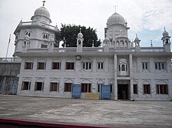
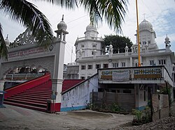
* '''Gurdwara Sri [[Guru Tegh Bahadur|Guru Tegbahadur]] Sahibji''': In the middle of the Dhubri Town and on the bank of the river Brahmaputra, this Gurdwara is situated. Sikh [[Guru Nanak]] visited this place in 1505 AD and met [[Sankardev|Sri Sankardeva]] during [[Guru Nanak]] Devji's way from [[Dhaka]] to [[Assam]]. Thereafter the Ninth Sikh [[Guru Teg Bahadur]] came to this place in the year 1666 and established the [[Gurdwara]] during 17th century accompany of Raja Ram Singh. [[Sikh]] devotees assemble in this Gurdwara every year in the month of December to mark the Martydom of [[Guru Teg Bahadur|Sri Guru Teg Bahadur]] with due solemnity and ceremony. Sikh devotees called reverence of Sahidee-Guru-Parav. | |||
* '''Panchpeer Dargaha''': It is a [[dargah|Mazar]] Sharif of five [[Sufi]] Saints who accompanied [[Raja Ram Singh]] during his time of [[Mughal Empire|Mughal]] conflict with the Ahom [[Regime]] of Assam. [[Guru Tegh Bahadur]] had also accompanied the [[Sufi]] Saints. | * '''Panchpeer Dargaha''': It is a [[dargah|Mazar]] Sharif of five [[Sufi]] Saints who accompanied [[Raja Ram Singh]] during his time of [[Mughal Empire|Mughal]] conflict with the Ahom [[Regime]] of Assam. [[Guru Tegh Bahadur]] had also accompanied the [[Sufi]] Saints. | ||
* '''Rangamati Mosque''': Rangamati Mosque or [[Panbari Mosque]] was built during [[17th century]] by '''Hussain Shah''', the Governor of [[Bengal]] (belonging to the pre-[[Mughal Empire|Mughal]] period which can be recognised from its typical architectural design). It is located in Panbari vicinity which is around | * '''Rangamati Mosque''': Rangamati Mosque or [[Panbari Mosque]] was built during [[17th century]] by '''Hussain Shah''', the Governor of [[Bengal]] (belonging to the pre-[[Mughal Empire|Mughal]] period which can be recognised from its typical architectural design). It is located in Panbari vicinity which is around 25 km from township of Dhubri. Rangamati area was once prosperous during the reign of the [[Koch dynasty|Koch]] rulers as a frontier post. During the [[Mughal Era|Mughal era]] Rangamati was a large [[Fortification|fort]] of the Mughal Army. This unique Mosque was used as a prayer place by the [[Muslims|Muslim]] Soldiers. There is also an [[Eidgah|Idgah]] and a deep well which were also constructed during the same period. Believers from all religious backgrounds visit this mosque and often throw coins in the well. | ||
* '''Other significant features''': Two | * '''Other significant features''': Two wetlands – Dheer Beel and Diplai Beel adjoin [[Chakrashila Wildlife Sanctuary|Chakrasila wildlife Sanctuary]]. These two Beels are home to a large number of fishes, turtles, prawn and birds both indigenous and migratory. | ||
* '''[[Chakrashila Wildlife Sanctuary|Chakrasila Wildlife Sanctuary]]''': In 1994 | * '''[[Chakrashila Wildlife Sanctuary|Chakrasila Wildlife Sanctuary]]''': In 1994 Chakrasila Hill Reserve Forest was declared as Chakrasila Hill Wildlife Sanctuary by the government of India covering 4558.7 hectares of land. The distribution of varieties of plant species in Chakrasila provides diverse niches for many species of wildlife. The significant golden langur exists in Chakrasila Wildlife Sanctuary in addition to other mammals like leopards, leopard cats, porcupines, pangolins, flying squirrels and civet cats. Adjutant storks, Indian owls, mynas, parakeets, doves, hornbills, jungle fowls, kingfishers, herons, darters, snipes and teals are the birds commonly found. Pythons, monitors, craits, cobras, turtles, teads and frogs are some reptiles and amphibia that are also found. It is in the Kokrajhar district and about 5 km from Kokrajhar town and 70;km from Dhubri Town. This sanctuary provides facilities and activities such as bird watching, forest trekking, wildlife and [[nature photography]]. Local guides are available on payment. There is a site for erecting tents and free accommodation for a group of 15 individuals with hygienic drinking water in the camp Tapoban provided by the local NGOs. | ||
* '''Florican Garden''': A newly setup garden-cum-natural park located at Bilasipara about 50 km from Dhubri Town. | * '''Florican Garden''': A newly setup garden-cum-natural park located at Bilasipara about 50 km from Dhubri Town. | ||
* '''Pagalathan Temple''': A Shiva temple along with some others temples and Chandardinga Hill, the hill said to have originated on the sank | * '''Pagalathan Temple''': A Shiva temple along with some others temples and Chandardinga Hill, the hill said to have originated on the sank ship of Chand Saudagar (Chand Trader from Behula-Lakhindar) in Salkocha near the Brahmaputra River located about 60 km from Dhubri. This place allows the view of Brahmaputra on one side and Chandardinga hill on other at Mahadevs foot. | ||
* '''Others''': Other tourist places include [[Matiabag Palace]] at Gauripur, Netai Dhubuni Ghat at Dhubri Town, Chandardinga Hillock, Dudhnath Mondir at Salkocha, Ramraikuti at Satrasal, Airport of | * '''Others''': Other tourist places include [[Matiabag Palace]] at Gauripur, Netai Dhubuni Ghat at Dhubri Town, Chandardinga Hillock, Dudhnath Mondir at Salkocha, Ramraikuti at Satrasal, Airport of World War II and Soreswar beel at Rupshi ok Kokrajhar district, Dhubri matches factory. | ||
==Parks== | ==Parks== | ||
| Line 382: | Line 345: | ||
* Rajiv Gandhi Children Park | * Rajiv Gandhi Children Park | ||
* Victoria Memorial Park | * Victoria Memorial Park | ||
== Flora and fauna == | == Flora and fauna == | ||
| Line 413: | Line 351: | ||
Geographical location of the Chakrasila Wildlife Sanctuary is in the latitude 26° 15' to 26° 26' N and longitude 90° 15' to 90 ° 20' E. It is in the District of Dhubri that is only 5% but mostly that is 95% in Kokrajhar district, the westernmost region of Assam. It is 68 km from the District headquarters Dhubri and 219 km from the Borjhar Airport of Guwahati City. | Geographical location of the Chakrasila Wildlife Sanctuary is in the latitude 26° 15' to 26° 26' N and longitude 90° 15' to 90 ° 20' E. It is in the District of Dhubri that is only 5% but mostly that is 95% in Kokrajhar district, the westernmost region of Assam. It is 68 km from the District headquarters Dhubri and 219 km from the Borjhar Airport of Guwahati City. | ||
There are several small springs for quenching the thirst of the wild animals of this hilly forest. | There are several small springs for quenching the thirst of the wild animals of this hilly forest. There are also two major perennial springs in the sanctuary at Howhowi Jhora and Bamuni Jhora. | ||
Climatic conditions of Chakrasila Wildlife Sanctuary is like that of temperate zone with dry winter and hot summer followed by heavy rains. Annual rainfall is between 200 and 400 cm. Soil is azonal, forestlike and hilly. temperature throughout the year generally varies between 8 °C to 30 °C. | Climatic conditions of Chakrasila Wildlife Sanctuary is like that of temperate zone with dry winter and hot summer followed by heavy rains. Annual rainfall is between 200 and 400 cm. Soil is azonal, forestlike and hilly. temperature throughout the year generally varies between 8 °C to 30 °C. | ||
The diverse ecosystems of Chakrasila present a model habitat diversity and support various mammalian species like tiger, leopard, golden langur, leopard cat, gaur, mongoose, porcupine, pangolin, flying squirrel, civet cat, etc. Along with all these prolific gifts of the nature Chakrasila has a wide variety of avifauna. | The diverse ecosystems of Chakrasila present a model [[habitat diversity]] and support various mammalian species like tiger, leopard, golden langur, leopard cat, gaur, mongoose, porcupine, pangolin, flying squirrel, civet cat, etc. Along with all these prolific gifts of the nature Chakrasila has a wide variety of avifauna. | ||
The two internationally recognized wetlands namely Dhir and Deeplai has not been yet taken inside the declared boundary of the sanctuary. But they are very a part of the Chakrasila eco-system. It is expected that in due course they will be included within the sanctuary. | The two internationally recognized wetlands namely Dhir and Deeplai has not been yet taken inside the declared boundary of the sanctuary. But they are very a part of the Chakrasila eco-system. It is expected that in due course they will be included within the sanctuary. | ||
| Line 426: | Line 364: | ||
== Politics == | == Politics == | ||
Dhubri is part of [[Dhubri (Lok Sabha constituency)]].<ref>{{cite web |url=http://archive.eci.gov.in/se2001/background/S03/AS_ACPC.pdf |title=List of Parliamentary & Assembly Constituencies |access-date=2008-10-05 |work=Assam |publisher=Election Commission of India |url-status=dead |archive-url=https://web.archive.org/web/20060504181808/http://archive.eci.gov.in/se2001/background/S03/AS_ACPC.pdf |archive-date=2006-05-04 }}</ref> | Dhubri is part of [[Dhubri (Lok Sabha constituency)]].<ref>{{cite web |url=http://archive.eci.gov.in/se2001/background/S03/AS_ACPC.pdf |title=List of Parliamentary & Assembly Constituencies |access-date=2008-10-05 |work=Assam |publisher=Election Commission of India |url-status=dead |archive-url=https://web.archive.org/web/20060504181808/http://archive.eci.gov.in/se2001/background/S03/AS_ACPC.pdf |archive-date=2006-05-04 }}</ref> | ||
[[Rakibul Hussain]] of [[Indian National Congress]] is the current Member of Parliament from Dhubri, serving in the [[18th Lok Sabha]]. | |||
== Media == | == Media == | ||
| Line 441: | Line 381: | ||
* [[Tapas Sen]], Theatre Artist | * [[Tapas Sen]], Theatre Artist | ||
* [[Saifuddin Ahmed]], Winner Of Bangladesh National Film Award for Best Supporting Actor | * [[Saifuddin Ahmed]], Winner Of Bangladesh National Film Award for Best Supporting Actor | ||
* [[Padma Shri]] [[Parbati Barua]], Internationally acclaimed "Queen of the Elephant". | |||
* [[Javed Zaman]], Indian first-class cricketer | * [[Javed Zaman]], Indian first-class cricketer | ||
==Photo Gallery== | |||
[[File:Dhubri Aerial View.jpg|thumb|Dhubri City Aerial View]] | |||
[[File:Dhubri City Skyline 2.jpg|thumb|Dhubri City Skyline View]] | |||
[[File:Dhubri Harishaba Area In 2024.jpg|thumb|Dhubri Harishaba area skyline view]] | |||
[[File:Harishaba area night view in 2024.jpg|thumb|Dhubri city night view]] | |||
[[File:Dhubri City Skyline View 3.jpg|thumb|Dhubri City Skyline View]] | |||
[[File:Guru Dwara Dhubri.jpg|thumb|Gurdwara Sri Guru Tegh Bahadur Sahib]] | |||
[[File:Building of DC Court Dhubri.jpg|thumb|Dhubri District Court New Building]] | |||
[[File:Academic Building of Dhubri Medical college & Hospital.jpg|thumb|Academic Building of Dhubri Medical college & Hospital]] | |||
[[File:District Library Dhubri.jpg|thumb|District Library Dhubri]] | |||
[[File:Ghate of Bholanath College, Dhubri.jpg|thumb|Bholanath College, Dhubri]] | |||
[[File:Bholanath College, Dhubri drone view 1.jpg|thumb|Bholanath College, Dhubri drone view 1]] | |||
[[File:Dhubri City Night View From Brahmaputra River.jpg|thumb|Dhubri City Night View From Brahmaputra River]] | |||
[[File:Dhubri railway station platform with child and flag.jpg|thumb|A child walking on the platform of Dhubri railway station (Indian train station in Assam) in late afternoon, with a large Indian flag flying in the background.]] | |||
[[File:Dhubri Phulbari River Bridge.jpg|thumb|Dhubri Phulbari bridge view from pillar no.125]] | |||
[[File:Dhubri City Street View.jpg|thumb|Dhubri City Street View Near Melamaidan]] | |||
== See also == | == See also == | ||
| Line 453: | Line 411: | ||
== External links == | == External links == | ||
{{Commons category}} | {{Commons category}} | ||
* [ | * [https://dhubri.assam.gov.in/ Dhubri District Official Website] | ||
* [http://gloriousindia.com/places/as/dhubri.html/ Glorious India Website] | * [http://gloriousindia.com/places/as/dhubri.html/ Glorious India Website] | ||
Latest revision as of 05:25, 28 March 2026
Dhubri | |
|---|---|
City | |
| Dhubri City | |
Dhubri City Aerial View Tegh Bahadur Gurudwara District Court Harishaba Area Harishaba Area At Night DMCH Academic Building Dhubri Administrative Area Dhubri Chowk Bazar Area | |
| Nicknames: Land of Rivers & Jute Hub Of Assam | |
  Dhubri Location in Assam | |
| Coordinates: 26°01′N 90°00′E / 26.02°N 90°E | |
| Country |  India India |
| State | Assam |
| District | Dhubri |
| Region | Lower Assam |
| Established | 1883 |
| Government | |
| • Type | Municipality |
| • Body | Dhubri Municipal Board |
| • Chairman | Dr. Debamoy Sanyal (BJP)[1] |
| • Vice Chairman | Ivy Lata Roy (BJP)[2] |
| • Deputy Commissioner | Sri Dibakar Nath, IAS |
| • Superintendent Of Police | Ms. Aparna N, IPS |
| Area | |
| • Total | 32 km2 (12 sq mi) |
| • Water | 4.9 km2 (1.9 sq mi) |
| • Rank | 8th in Assam |
| Population (2025) | |
| • Total | 155,000 |
| • Rank | 10th in Assam |
| • Density | 6,300/km2 (16,000/sq mi) |
| Demonym | Dhubrian |
| Time zone | UTC+5:30 (IST) |
| PIN | 783301 |
| ISO 3166 code | IN-AS |
| Vehicle registration | AS-17 |
| Sex Ratio | 953 ♀️/ 1000 ♂️ |
| Climate | Cwa |
| Official Language | Assamese[3] |
| Most spoken language | Bengali |
| Literacy Rate |  89.34% Template:Colour 89.34% Template:Colour |
| Lok Sabha Constituency | Dhubri |
| Vidhan Sabha Constituency | Dhubri |
| Website | https://dhubri.assam.gov.in/ |

Dhubri is a city and the administrative centre of Dhubri district in the Indian state of Assam. It is an old town on the bank of the Brahmaputra River, with historical significance. In 1883, the town was first constituted as a municipal board under the British regime. It is situated about 277.4 kilometres (172 mi) west from Dispur, the state capital of Assam.
The town is also an important commercial centre and had a busy river port, particularly for jute. Dhubri is called the "Land of Rivers" as it is covered on three sides by the Brahmaputra and Gangadhar rivers.[4]
History[edit | edit source]
 |

Until 1874, Dhubri was mostly ruled by Koch Kings. In 1874, the British government created a new province named Assam Valley Province and incorporated Goalpara district area comprising three civil subdivisions Dhubri, Goalpara and Kokrajhar with the new Assam Province. In 1879, the district headquarters was shifted from Goalpara to Dhubri city. The district of Dhubri is again subdivided in three districts namely Dhubri, Goalpara and Kokrajhar. The City of Dhubri falls under the jurisdiction of the district of Dhubri whose headquarters is at city Dhubri.
The present Dhubri District is one of the three Civil Sub-divisions of erst-while Goalpara district, established in 1876 during British regime. In 1879 the District headquarters was shifted from Goalpara to Dhubri.
In 1983 Goalpara district was divided into four separate districts and Dhubri is one of those. Covering an area of 2,838 km2. including forests, riverines, hills etc. the district has become the most densely populated district in India with a density of 584 persons per km2.(As per 2001 census).
The Dhubri city was first constituted as a Municipality in 1883. The Dhubri city is 290 km far from the State Capital at Dispur.
Demographics[edit | edit source]
- Hinduism (64.8%)
- Islam (33.5%)
- Christianity (0.21%)
- others (1.55%)
As of 2011[update] India census,[6] Dhubri had a population 63,388 and Dhubri - Gauripur Metropolitan area had a Population 1,22,400. Males constitute 51% of the population and females 49%. Dhubri has an average literacy rate of 74%, higher than the national average of 59.5%: male literacy is 79% and, female literacy is 68%. In Dhubri, 11% of the population is under 6 years of age. With close to 75% of its population Muslims, it is one of the minority concentrated districts of India.
Most of these people are Bengali Hindus, Bengali Muslims, Deshi Muslims, Koch Rajbongshi Hindus. Assamese, Goalpariya and Bengali are the major languages spoken in the town.
Geography and climate[edit | edit source]
Dhubri lies at 89.5 degree east longitude and 26.1 degree north latitude, and about 34 metres or 110 feet above sea level. Dhubri is covered by rivers on three sides, predominated by mighty Brahmaputra River.
As is typical for Assam and Tripura, Dhubri has a monsoon-influenced humid subtropical climate (Köppen Cwa), being a little too cool to qualify as a tropical monsoon climate. The "cool" or winter season from November to February is warm to very warm during the afternoon, and pleasantly cool in the morning. The "hot" season of March and April is indeed hot and sees increasing humidity and rain, leading into the oppressively humid and extremely wet monsoon season from May to the middle of October.
| Climate data for Dhubri (1991–2020, extremes–2020) | |||||||||||||
|---|---|---|---|---|---|---|---|---|---|---|---|---|---|
| Month | Jan | Feb | Mar | Apr | May | Jun | Jul | Aug | Sep | Oct | Nov | Dec | Year |
| Record high °C (°F) | 29.9 (85.8) |
32.1 (89.8) |
37.5 (99.5) |
39.6 (103.3) |
38.0 (100.4) |
38.7 (101.7) |
36.7 (98.1) |
36.8 (98.2) |
35.5 (95.9) |
34.3 (93.7) |
30.6 (87.1) |
27.1 (80.8) |
39.6 (103.3) |
| Average high °C (°F) | 21.4 (70.5) |
25.3 (77.5) |
29.6 (85.3) |
30.0 (86.0) |
30.5 (86.9) |
31.1 (88.0) |
31.1 (88.0) |
31.9 (89.4) |
30.9 (87.6) |
29.1 (84.4) |
26.2 (79.2) |
22.9 (73.2) |
28.3 (82.9) |
| Daily mean °C (°F) | 17.1 (62.8) |
20.4 (68.7) |
24.5 (76.1) |
26.2 (79.2) |
27.2 (81.0) |
28.3 (82.9) |
29.0 (84.2) |
29.4 (84.9) |
28.4 (83.1) |
26.6 (79.9) |
22.6 (72.7) |
18.8 (65.8) |
24.9 (76.8) |
| Average low °C (°F) | 12.5 (54.5) |
15.4 (59.7) |
19.0 (66.2) |
21.7 (71.1) |
23.5 (74.3) |
25.4 (77.7) |
26.3 (79.3) |
26.6 (79.9) |
25.9 (78.6) |
23.5 (74.3) |
18.8 (65.8) |
14.7 (58.5) |
21.1 (70.0) |
| Record low °C (°F) | 5.8 (42.4) |
7.3 (45.1) |
11.4 (52.5) |
9.4 (48.9) |
17.5 (63.5) |
18.7 (65.7) |
20.8 (69.4) |
22.0 (71.6) |
19.4 (66.9) |
18.1 (64.6) |
11.9 (53.4) |
8.1 (46.6) |
5.8 (42.4) |
| Average rainfall mm (inches) | 7.7 (0.30) |
11.4 (0.45) |
65.6 (2.58) |
198.4 (7.81) |
351.7 (13.85) |
566.2 (22.29) |
359.5 (14.15) |
292.5 (11.52) |
294.6 (11.60) |
156.9 (6.18) |
3.5 (0.14) |
1.6 (0.06) |
2,309.6 (90.93) |
| Average rainy days | 0.8 | 1.2 | 3.5 | 9.7 | 15.1 | 17.5 | 14.7 | 11.3 | 10.9 | 5.1 | 0.4 | 0.3 | 90.3 |
| Average relative humidity (%) (at 17:30 IST) | 74 | 65 | 59 | 72 | 79 | 84 | 86 | 84 | 86 | 82 | 77 | 76 | 84 |
| Source 1: India Meteorological Department[8] | |||||||||||||
| Source 2: Tokyo Climate Center (mean temperatures 1991–2020)[9] | |||||||||||||
Colleges[edit | edit source]


Local colleges include
- Bhola Nath College or "B. N. College"' (established in 1946), the oldest college in western Assam.
- Dhubri Law College
- Dhubri Girls' College
- Dhubri Medical College and Hospital
- Pramathesh Barua College, Gauripur
- Chilarai College
- Dhubri PGTT College
- Jamia Millia Islamia University Open & Distance Learning Centre
- Ajmal Super 40 (Dhubri)
- College of Advanced Technical Studies
Transportation[edit | edit source]
Airport[edit | edit source]

Rupsi Airport at Kokrajhar district is the nearest airport which is only about 15 km from the Dhubri main city and 5 km away from Gauripur town. It was constructed during World War II by the British mainly for military purpose to accommodate 52 jet airplanes. Until 1983, the Indian Airlines and some private commercial flights operated regularly between Calcutta, Guwahati and Dhubri. The airport started its commercial service after 38 years in 2021, and the airport is operational with connectivity to Kolkata and state capital Guwahati. Flybig operates flights by ATR aircraft under RCS UDAN.
Railway[edit | edit source]

Dhubri railway station serves the town of Dhubri. The station lies on New Cooch Behar-Golokganj branch line and Fakiragram–Dhubri branch line of Northeast Frontier Railway, Alipurduar railway division.
Sengajan multimodal waterways terminal[edit | edit source]
Dhubri multimodal waterways terminal on Brahmaputra in Dhubri is being developed as part of Bharatmala and Sagarmala projects.[10] The city had a very busy river port on the bank of the Brahmaputra which was used as an international trade centre with the neighbouring countries, specially during the British Raj.
Railway[edit | edit source]
The importance of the railway station and the MG line was also decreased since 1947, when the direct line to Calcutta was snapped as it ran through erstwhile East Pakistan (now Bangladesh). The train service has newly started on 2010 again, and it is functioning smoothly. However the train services running from the Dhubri railway station are taking a new route from Dhubri to Kamakhya and Guwahati Junction. Trains originating from Dhubri station are, Dhubri – Silghat (Rajya Rani Express), Dhubri – Siliguri (Inter City Express) Dhubri Fakiragram passenger and New Bongaigaon Siliguri Jn Demu Special Via Dhubri
Tourism[edit | edit source]
Dhubri District has a number of tourist sites, including the banks of river Brahmaputra with its green fields, blue hills and hillock. The Gurdwara Tegh Bahadur Shaibji, the Rangamati Mosque, Mahamaya Dham, Chakrasila wildlife sanctuary, Matiabagh Hawa Mahal, Satrashal Dham, Panch Peer Dargaha, and other royal palaces attract the people for their unique structures, religious sanctity and mythological importance.[citation needed]
Dhubri is the location of the Sikh Gurdwara Gurdwara Damdama Sahib or Thara Sahib.
Places of interest[edit | edit source]


- Mahamaya Dham and shakti pith Snan Ghat:- of Bogribari, about 30–35 km east from Dhubri town is next to Kamakhya (Guwahati) and Madan-Mohan (Cooch Behar). Originally the mother Goddess Mahamaya of Parvatjowar was worshipped by the local people like Kacharies, Koches and Naths. It was the presiding deity of the Jaminder of Parvatjowar. Nowadays the mother Mahamaya is worshipped by all Hindus.
- Gurdwara Sri Guru Tegbahadur Sahibji: In the middle of the Dhubri Town and on the bank of the river Brahmaputra, this Gurdwara is situated. Sikh Guru Nanak visited this place in 1505 AD and met Sri Sankardeva during Guru Nanak Devji's way from Dhaka to Assam. Thereafter the Ninth Sikh Guru Teg Bahadur came to this place in the year 1666 and established the Gurdwara during 17th century accompany of Raja Ram Singh. Sikh devotees assemble in this Gurdwara every year in the month of December to mark the Martydom of Sri Guru Teg Bahadur with due solemnity and ceremony. Sikh devotees called reverence of Sahidee-Guru-Parav.
- Panchpeer Dargaha: It is a Mazar Sharif of five Sufi Saints who accompanied Raja Ram Singh during his time of Mughal conflict with the Ahom Regime of Assam. Guru Tegh Bahadur had also accompanied the Sufi Saints.
- Rangamati Mosque: Rangamati Mosque or Panbari Mosque was built during 17th century by Hussain Shah, the Governor of Bengal (belonging to the pre-Mughal period which can be recognised from its typical architectural design). It is located in Panbari vicinity which is around 25 km from township of Dhubri. Rangamati area was once prosperous during the reign of the Koch rulers as a frontier post. During the Mughal era Rangamati was a large fort of the Mughal Army. This unique Mosque was used as a prayer place by the Muslim Soldiers. There is also an Idgah and a deep well which were also constructed during the same period. Believers from all religious backgrounds visit this mosque and often throw coins in the well.
- Other significant features: Two wetlands – Dheer Beel and Diplai Beel adjoin Chakrasila wildlife Sanctuary. These two Beels are home to a large number of fishes, turtles, prawn and birds both indigenous and migratory.
- Chakrasila Wildlife Sanctuary: In 1994 Chakrasila Hill Reserve Forest was declared as Chakrasila Hill Wildlife Sanctuary by the government of India covering 4558.7 hectares of land. The distribution of varieties of plant species in Chakrasila provides diverse niches for many species of wildlife. The significant golden langur exists in Chakrasila Wildlife Sanctuary in addition to other mammals like leopards, leopard cats, porcupines, pangolins, flying squirrels and civet cats. Adjutant storks, Indian owls, mynas, parakeets, doves, hornbills, jungle fowls, kingfishers, herons, darters, snipes and teals are the birds commonly found. Pythons, monitors, craits, cobras, turtles, teads and frogs are some reptiles and amphibia that are also found. It is in the Kokrajhar district and about 5 km from Kokrajhar town and 70;km from Dhubri Town. This sanctuary provides facilities and activities such as bird watching, forest trekking, wildlife and nature photography. Local guides are available on payment. There is a site for erecting tents and free accommodation for a group of 15 individuals with hygienic drinking water in the camp Tapoban provided by the local NGOs.
- Florican Garden: A newly setup garden-cum-natural park located at Bilasipara about 50 km from Dhubri Town.
- Pagalathan Temple: A Shiva temple along with some others temples and Chandardinga Hill, the hill said to have originated on the sank ship of Chand Saudagar (Chand Trader from Behula-Lakhindar) in Salkocha near the Brahmaputra River located about 60 km from Dhubri. This place allows the view of Brahmaputra on one side and Chandardinga hill on other at Mahadevs foot.
- Others: Other tourist places include Matiabag Palace at Gauripur, Netai Dhubuni Ghat at Dhubri Town, Chandardinga Hillock, Dudhnath Mondir at Salkocha, Ramraikuti at Satrasal, Airport of World War II and Soreswar beel at Rupshi ok Kokrajhar district, Dhubri matches factory.
Parks[edit | edit source]
- Netai Dhubuni Park
- Rajiv Gandhi Children Park
- Victoria Memorial Park
Flora and fauna[edit | edit source]
On 14 July 1994, a virgin little forest patch of Dhubri District but mostly that is 95% in Kokrajhar district of Assam was declared as a wildlife sanctuary by the gazette notification of the Assam Government. This sanctuary has been named as "Chakrashila Wildlife Sanctuary". This is the youngest sanctuary of the North East India having an area of 11,260.00 acres (45.5676 km2). Chakrasila is unique because of the presence of golden langur (Presbytis geei) which is found nowhere else except along the Assam and Bhutan border. Besides, the virgin forest of Chakrasila Wildlife Sanctuary is endowed with rare specimens of trees, shrubs, medicinal plants, mammals, reptiles and exquisite birds and insects.
Geographical location of the Chakrasila Wildlife Sanctuary is in the latitude 26° 15' to 26° 26' N and longitude 90° 15' to 90 ° 20' E. It is in the District of Dhubri that is only 5% but mostly that is 95% in Kokrajhar district, the westernmost region of Assam. It is 68 km from the District headquarters Dhubri and 219 km from the Borjhar Airport of Guwahati City.
There are several small springs for quenching the thirst of the wild animals of this hilly forest. There are also two major perennial springs in the sanctuary at Howhowi Jhora and Bamuni Jhora.
Climatic conditions of Chakrasila Wildlife Sanctuary is like that of temperate zone with dry winter and hot summer followed by heavy rains. Annual rainfall is between 200 and 400 cm. Soil is azonal, forestlike and hilly. temperature throughout the year generally varies between 8 °C to 30 °C.
The diverse ecosystems of Chakrasila present a model habitat diversity and support various mammalian species like tiger, leopard, golden langur, leopard cat, gaur, mongoose, porcupine, pangolin, flying squirrel, civet cat, etc. Along with all these prolific gifts of the nature Chakrasila has a wide variety of avifauna.
The two internationally recognized wetlands namely Dhir and Deeplai has not been yet taken inside the declared boundary of the sanctuary. But they are very a part of the Chakrasila eco-system. It is expected that in due course they will be included within the sanctuary. Courtesy : Nature's Beckon ( An Environmental Activist of North-East )
Politics[edit | edit source]
Dhubri is part of Dhubri (Lok Sabha constituency).[12]
Rakibul Hussain of Indian National Congress is the current Member of Parliament from Dhubri, serving in the 18th Lok Sabha.
Media[edit | edit source]
Dhubri has an All India Radio Relay station known as Akashvani Dhubri. It broadcasts on FM frequencies.
Notable people[edit | edit source]
- Pramathesh Barua, Bollywood filmmaker
- Jamuna Barua, Bollywood actress
- Padma Shri Pratima Barua Pandey, singer
- Vijay Saxena, Bollywood actor
- Priyadarshini Chatterjee, Femina Miss India World in 2016
- B. C. Sanyal, painter, sculptor, Art teacher
- Sarat Chandra Sinha, fifth Chief Minister of Assam, social activist.
- Rebati Mohan Dutta Choudhury, noted Bengali, Assamese litterateur.
- Tapas Sen, Theatre Artist
- Saifuddin Ahmed, Winner Of Bangladesh National Film Award for Best Supporting Actor
- Padma Shri Parbati Barua, Internationally acclaimed "Queen of the Elephant".
- Javed Zaman, Indian first-class cricketer
Photo Gallery[edit | edit source]


See also[edit | edit source]
References[edit | edit source]
- ↑ Mehtab Uddin Ahmed (25 March 2026). "Dhubri's historic Ashokastami mela in Assam enters 56th year as symbol of communal unity". India Today NE. Archived from the original on 26 March 2026. Retrieved 28 March 2026.
- ↑ "Newly-elected chairman, vice-chairperson of Dhubri Municipal Board take oath". The Sentinel (Guwahati). 8 April 2022. Archived from the original on 8 April 2022. Retrieved 28 March 2026.
- ↑ "Assam assembly accords associate official language status to bodo". NDTV. 30 December 2020.
- ↑ "Priceless heritage gets funds to survive". The Telegraph. Calcutta. 13 October 2007. Archived from the original on 10 November 2007. Retrieved 10 June 2018.
- ↑ "C-1 Population By Religious Community". censusindia.gov.in. Retrieved 26 January 2021.
- ↑ "Census of India 2001: Data from the 2001 Census, including cities, villages and towns (Provisional)". Census Commission of India. Archived from the original on 16 June 2004. Retrieved 1 November 2008.
- ↑ "C-16 Population By Mother Tongue - Dhubri". censusindia.gov.in. Retrieved 16 August 2020.
- ↑ "Climatological Tables of Observatories in India 1991-2020" (PDF). India Meteorological Department. Retrieved 8 April 2024.
- ↑ "Normals Data: Dhubri – India Latitude: 26.02°N Longitude: 89.98°E Height: 35 (m)". Japan Meteorological Agency. Retrieved 1 December 2022.
- ↑ Bharatmala presentation
- ↑ "Pin Code of Dhubri". citypincode.in. Retrieved 13 May 2014.
- ↑ "List of Parliamentary & Assembly Constituencies" (PDF). Assam. Election Commission of India. Archived from the original (PDF) on 4 May 2006. Retrieved 5 October 2008.
