



No edit summary |
Piniteinfra (talk | contribs) refined lead further and improved wording |
||
| Line 2: | Line 2: | ||
{{Use Indian English|date=January 2015}} | {{Use Indian English|date=January 2015}} | ||
{{Use dmy dates|date=January 2015}} | {{Use dmy dates|date=January 2015}} | ||
{{Infobox settlement | {{Infobox settlement | ||
| name | | name = Rupnagar district | ||
| native_name | | native_name = | ||
| native_name_lang | | native_name_lang = | ||
| other_name | | other_name = | ||
| settlement_type | | settlement_type = [[List of districts of Punjab, India|District]] of [[Punjab, India|Punjab]] | ||
| image_skyline = {{Photomontage | |||
| image_skyline | |size = 250 | ||
| image_caption | |photo1a = 1 Sri Kesgarh Takhat Anandpur Sahib Khalsa birthplace Punjab India.jpg | ||
| image_map | |photo2a = Rupnagar, Punjab, India - panoramio (38).jpg | ||
| map_alt | }} | ||
| map_caption | | image_caption = Top: Kesgarh Takht<br />Bottom: Anandpur Sahib | ||
| image_map = Rupnagar in Punjab (India).svg | |||
| coordinates | | image_map1 = | ||
| subdivision_type | | map_alt = | ||
| subdivision_name | | map_caption = Location in Punjab | ||
| subdivision_type1 | | coordinates = {{coord|30.97|N|76.51|E|display=inline,title}} | ||
| subdivision_name1 | | subdivision_type = Country | ||
| established_title | | subdivision_name = {{flag|India}} | ||
| established_date | | subdivision_type1 = State | ||
| named_for | | subdivision_name1 = {{flagicon image|Emblem of Punjab (India) on a white background (1).png}} [[Punjab, India|Punjab]] | ||
| seat_type | | established_title = | ||
| seat | | established_date = | ||
| leader_title1 | | named_for = Raja Rokeshar's son, Rup Sen | ||
| leader_name1 | | seat_type = Headquarters | ||
| unit_pref | | seat = [[Rupnagar]] | ||
| area_total_km2 | | leader_title1 = Administrator of District | ||
| elevation_footnotes | | leader_name1 = | ||
| elevation_m | | unit_pref = Metric | ||
| population_total | | area_total_km2 = 1440 | ||
| population_as_of | | elevation_footnotes = | ||
| population_footnotes | | elevation_m = | ||
| population_total = 684,627 | |||
| population_as_of = 2011 | |||
| population_footnotes = {{cref|‡}} | |||
| population_density_km2 = auto | | population_density_km2 = auto | ||
| demographics_type1 | | demographics_type1 = Languages | ||
| demographics1_title1 | | demographics1_title1 = Official | ||
| timezone1 | | timezone1 = [[Indian Standard Time|IST]] | ||
| utc_offset1 | | utc_offset1 = +5:30 | ||
| postal_code_type | | postal_code_type = <!-- [[Postal Index Number|PIN]] --> | ||
| postal_code | | postal_code = | ||
| iso_code | | iso_code = [[ISO 3166-2:IN|IN-PB-RU]] | ||
| blank1_name_sec1 | | blank1_name_sec1 = Literacy | ||
| blank1_info_sec1 | | blank1_info_sec1 = 82.19% | ||
| website | | website = {{URL|http://rupnagar.nic.in/}} | ||
| leader_title2 | | leader_title2 = Deputy commissioner | ||
| demographics1_info1 | | demographics1_info1 = [[Punjabi language|Punjabi]], [[Hindi]] | ||
}} | }} | ||
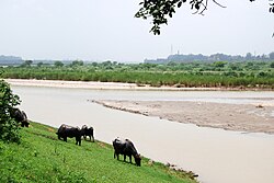
[[File:Satluj P012.JPG|thumb|250px|Cattle grazing on the banks of river [[Sutlej]]]] | [[File:Satluj P012.JPG|thumb|250px|Cattle grazing on the banks of river [[Sutlej]]]] | ||
[[File:Satluj S058.JPG|thumb|250px|Gurdwara Shri Tibi Sahib on the banks of river [[Sutlej]]]] | [[File:Satluj S058.JPG|thumb|250px|Gurdwara Shri Tibi Sahib on the banks of river [[Sutlej]]]] | ||
'''Rupnagar district''' is one of twenty-three districts in the state of [[Punjab, India|Punjab]], India. The city of [[Rupnagar]] is said to have been founded by a Raja called Rokeshar, who ruled during the 11th century and named it after his son Rup Sen. It is also the site of an ancient town of the [[Indus Valley civilization]]. The major cities in Rupnagar District are [[Morinda, India|Morinda]], [[Nangal]] and [[Anandpur Sahib]]. Morinda is also known as Baghwāla "[The City] of Gardens." Morinda is located on the [[Chandigarh]]-[[Ludhiana]] Highway. The Nangal dam, part of [[Bhakra Dam]] in [[Himachal Pradesh]], lies in the border of Rupnagar district and [[Bilaspur district, Himachal Pradesh|Bilaspur district]] of Himachal Pradesh. [[Dadhi]] is one of the most important villages of the district, particularly because of Gurudwara Sri Hargobindsar Sahib. It is bordered by [[Bilaspur district, Himachal Pradesh|Bilaspur]], [[Una district|Una]] and [[Solan district|Solan]] districts of [[Himachal Pradesh]] and [[Hoshiarpur district|Hoshiarpur]], [[Mohali district|Mohali]], [[Ludhiana district|Ludhiana]], [[Fatehgarh Sahib district|Fategarh Sahib]] and [[Shaheed Bhagat Singh Nagar district|Shahid Bhagat Singh Nagar]] districts of Punjab. | |||
<!-- | |||
I have hidden the extensive unsourced claims. Please restore anything that citations from reliable sources can confirm. | |||
==Ropar== | ==Ropar== | ||
Ropar is a 21-meter-high ancient mound overlaying the [[Shiwalik]] (also spelled as Sivalik or Shivalik) deposition on the left bank of the river [[Sutlej River|Sutlej]] where it merges into the plains. | Ropar is a 21-meter-high ancient mound overlaying the [[Shiwalik]] (also spelled as Sivalik or Shivalik) deposition on the left bank of the river [[Sutlej River|Sutlej]] where it merges into the plains. It has yielded a sequence of six cultural periods or phases with some breaks from the [[Indus Valley Civilization|Harappan]] times to the present day. The excavations were carried out by the [[Archaeological Survey of India]]. The migration of the Harappans to Ropar has been [[postulated]] through the lost [[Sarasvati River|Saraswati River]] to the Sutlej as both rivers once belonged to one system. | ||
=== Period I === | === Period I === | ||
At Ropar excavation, the lowest levels yielded the [[Indus Valley Civilization|Harappan]] traits in Period 1, which falls in the [[Protohistory|proto-historic]] period. A major find was a steatite seal in the Indus script used for the authentication of trading goods, impression of the seal on a [[terracotta]] lump of burnt [[clay]], chert blades, | At Ropar excavation, the lowest levels yielded the [[Indus Valley Civilization|Harappan]] traits in Period 1, which falls in the [[Protohistory|proto-historic]] period. A major find was a steatite seal in the Indus script used for the authentication of trading goods, impression of the seal on a [[terracotta]] lump of burnt [[clay]], chert blades, copper implements, terracotta [[beads]], and [[bangle]]s and typically standardized pottery of [[Indus Valley civilization]]. They flourished in all the Harappan cities and townships. | ||
The dead were buried with head generally to the north and with funerary vessels as unearthed in cemetery R-37 at Harappa (Sind, Pakistan). What led the Harappans to desert the site is not known. | The dead were buried with head generally to the north and with funerary vessels as unearthed in cemetery R-37 at Harappa (Sind, Pakistan). What led the Harappans to desert the site is not known. | ||
| Line 74: | Line 79: | ||
In the next phase, Period VI revealed the evidence of the [[Shunga Empire|Shungas]], [[Kushan Empire|Kushanas]], and [[Gupta Empire|Guptas]] and their successors. Excavations also revealed successive building levels of various dynasties. In the upper levels, a hoard of copper coins of Kushan and Gupta rules were found. This includes a gold coin issued by [[Chandragupta Maurya|Chandragupta]]-Kumerdevi of the [[Gupta Empire|Gupta dynasty]], which is also known as the golden age in ancient Indian history. | In the next phase, Period VI revealed the evidence of the [[Shunga Empire|Shungas]], [[Kushan Empire|Kushanas]], and [[Gupta Empire|Guptas]] and their successors. Excavations also revealed successive building levels of various dynasties. In the upper levels, a hoard of copper coins of Kushan and Gupta rules were found. This includes a gold coin issued by [[Chandragupta Maurya|Chandragupta]]-Kumerdevi of the [[Gupta Empire|Gupta dynasty]], which is also known as the golden age in ancient Indian history. | ||
A large number of terracotta figurines of Shunga, Kushana, and Gupta periods were also discovered. Amongst them were a Yakshi figure with cherubic expression and a beautiful seated figure of a lady playing on the lyre reminiscent of [[Samudragupta|Samudragupta’s]] figure in a similar position on the famous gold coins of the Gupta dynasty. | A large number of terracotta figurines of Shunga, Kushana, and Gupta periods were also discovered. Amongst them were a Yakshi figure with cherubic expression and a beautiful seated figure of a lady playing on the lyre reminiscent of [[Samudragupta|Samudragupta’s]] figure in a similar position on the famous gold coins of the Gupta dynasty. A set of three silver utensils for ritualistic purposes with Greek influence depicts the fine craftsmanship of the Gupta dynasty in its chased decoration. | ||
The pottery of this period in the upper levels is for the most part redware and is frequently decorated with incised motifs. | The pottery of this period in the upper levels is for the most part redware and is frequently decorated with incised motifs. After a short break, there is evidence of a fresh occupation identified as Period V commencing around the early 6th century and continuing for three or four centuries. The coins of Toramana (circa AD 500) and Mihirakula (circa 510-40) have been recovered from these levels. The spacious brick building of the fifth period was constricted neatly and evidence showed a good measure of prosperity during this period. | ||
Probably after desertion, a new town sprang up here around 13th century AD on the same site named '''Period VI''' and it continues to flourish to the present day. | Probably after desertion, a new town sprang up here around 13th century AD on the same site named '''Period VI''' and it continues to flourish to the present day. | ||
An archaeological site | An archaeological site museum has been set up to house some of the antiquities of Rupar along with the photographs displaying excavation material. | ||
--> | |||
== Location == | == Location == | ||
[[File:Rupnagar District Tourist Places.png|thumbnail|right|Tourist places in District Rupnagar]] | [[File:Rupnagar District Tourist Places.png|thumbnail|right|Tourist places in District Rupnagar]] | ||
Rupnagar district, included in the [[Patiala district|Patiala]] Division of [[Punjab, India|Punjab]] falls between north latitude 30°-32' and 31°-24' and east longitude 76°-18' and 76°-55'. [[Rupnagar]] (formerly known as Ropar) town, the district headquarters is 42 km from [[Chandigarh]], the state capital. | Rupnagar district, included in the [[Patiala district|Patiala]] Division of [[Punjab, India|Punjab]] falls between north latitude 30°-32' and 31°-24' and east longitude 76°-18' and 76°-55'. [[Rupnagar]] (formerly known as Ropar) town, the district headquarters is 42 km from [[Chandigarh]], the state capital. The district adjoins [[Shahid Bhagat Singh Nagar district|Shahid Bhagat Singh Nagar]] (formerly known as Nawanshahar), [[Mohali district|Mohali]] and [[Fatehgarh Sahib district|Fatehgarh Sahib]] Districts of Punjab. The district comprises 4 Tehsils, [[Rupnagar]], [[Anandpur Sahib]], [[Chamkaur Sahib]] and [[Nangal]] and includes 617 villages and 7 towns namely Rupnagar, Chamkaur Sahib, Anandpur Sahib, [[Morinda, India|Morinda]], [[Kiratpur Sahib]] and [[Nangal]], Bela. All the towns except Chamkaur sahib fall on the railway line. The [[Satluj River|Satluj river]] passes close (2 to 5 km) to the towns of Nangal, Rupnagar, Bela and Anandpur Sahib. Rupnagar falls in [[Puadh]] region except it's nurpur bedi sub-tehsil which is geographically in [[Doaba]] region of Punjab. | ||
== | == Climate == | ||
{{Unsourced section|date=January 2025}} | |||
Rupnagar | The climate of Rupnagar District is characterized by its general dryness (except in the south-west [[monsoon]] season), hot summer, and bracingly cold winter. The year may be divided into four seasons. The period from about the middle of November to February is the cold season. This is followed by the summer season from March to about the end of June. The south-west monsoon season commences late in June and continues up to about the middle of September. The period from mid-September to the middle of November constitute the post-monsoon or transition season. The temperature ranges from a minimum of 4 °C in winter to 45 °C in summer. May and June are generally hottest months and December and January are the coldest months. The relative humidity is high, averaging about 70 percent during monsoon. The average annual rainfall in the district is 775.6 mm. About 78 percent of the annual rainfall is received during the period from June to September. The soils of the District vary in texture generally from loam to silty clay loam except along the [[Sutlej River]] and where some sandy patches may be found. [[Chamkaur Sahib]] and [[Kharar, Mohali|Kharar]] blocks have sodic soils. The soils of Anandpur Sahib and Rupnagar blocks are undulating. | ||
== Politics == | |||
{| class="wikitable sortable" | |||
|- | |||
! No. | |||
! Constituency | |||
! Name of MLA | |||
! colspan="2" | Party | |||
!Bench | |||
|- | |||
!49 | |||
| [[Anandpur Sahib Assembly constituency|Anandpur Sahib]] | |||
|[[Harjot Singh Bains]] | |||
| {{Full party name with color|Aam Aadmi Party}} | |||
|Government | |||
|- | |||
!50 | |||
|[[Rupnagar Assembly constituency|Rupnagar]] | |||
|[[Dinesh Chadha]] | |||
| {{Full party name with color|Aam Aadmi Party}} | |||
|Government | |||
|- | |||
!51 | |||
| [[Chamkaur Sahib Assembly constituency|Chamkaur Sahib]] (SC) | |||
| [[Charanjit Singh (politician)|Dr Charanjit Singh]] | |||
| {{Full party name with color|Aam Aadmi Party}} | |||
|Government | |||
|} | |||
==Tehsils in Rupnagar district== | |||
==Tehsils in Rupnagar | |||
* [[Anandpur Sahib]] | * [[Anandpur Sahib]] | ||
* [[Chamkaur Sahib]] | * [[Chamkaur Sahib]] | ||
| Line 105: | Line 134: | ||
* [[Anandpur Sahib, Ropar|Anandpur Sahib]] | * [[Anandpur Sahib, Ropar|Anandpur Sahib]] | ||
* [[Chamkaur Sahib, Ropar|Chamkaur Sahib]] | * [[Chamkaur Sahib, Ropar|Chamkaur Sahib]] | ||
* [[ | * [[Kiratpur Sahib]] | ||
* [[Morinda, Punjab|Morinda]] | * [[Morinda, Punjab|Morinda]] | ||
* [[Nangal, Ropar|Nangal]] | * [[Nangal, Ropar|Nangal]] | ||
* [[Rupnagar]] | * [[Rupnagar]] | ||
* [[Kamalpur, | * [[Kamalpur, Rupnagar|Kamalpur]] | ||
* [[ | * [[Ghanauli]] | ||
* [[Dadhi]] | * [[Dadhi]] | ||
* | Nurpur bedi | ||
* Bharatgarh | |||
* [[Kartarpur, Rupnagar|Kartarpur]] | * [[Kartarpur, Rupnagar|Kartarpur]] | ||
* [[Bara, Punjab]] - A Famous Archelogical Site Village In Rupnagar District | * [[Bara, Punjab]] - A Famous Archelogical Site Village In Rupnagar District | ||
==Demographics== | ==Demographics== | ||
According to the [[2011 census of India|2011 census]] Rupnagar district has a [[Demographics of India|population]] of 684,627,<ref name=districtcensus>{{cite web | url = | {{historical populations|11=1901|12=220055|13=1911|14=190585|15=1921|16=189159|17=1931|18=207804|19=1941|20=236725|21=1951|22=251804|23=1961|24=319389|25=1971|26=357783|27=1981|28=439165|29=1991|30=535970|31=2001|32=628846|33=2011|34=684627|percentages=pagr|footnote=source:<ref>[http://www.censusindia.gov.in/2011census/PCA/A2_Data_Table.html Decadal Variation In Population Since 1901]</ref>|align=middle}} | ||
}}</ref> or the US state of [[North Dakota]].<ref>{{cite web|url=http://2010.census.gov/2010census/data/apportionment-pop-text.php|title=2010 Resident Population Data|publisher=U. S. Census Bureau|access-date=2011-09-30| quote = | |||
}}</ref> This gives it a ranking of 507th in India (out of a total of [[Districts of India|640]]).<ref name=districtcensus/> | According to the [[2011 census of India|2011 census]] Rupnagar district has a [[Demographics of India|population]] of 684,627,<ref name=districtcensus>{{cite web |year=2011 |title=District Census Handbook: Rupnagar |url=https://censusindia.gov.in/nada/index.php/catalog/1012/download/3062/DH_2011_0317_PART_A_DCHB_RUPNAGAR.pdf |website=censusindia.gov.in |publisher=[[Registrar General and Census Commissioner of India]]}}</ref> roughly equal to the nation of [[Equatorial Guinea]]<ref name="cia">{{cite web | author = US Directorate of Intelligence | title = Country Comparison:Population | url = https://www.cia.gov/library/publications/the-world-factbook/rankorder/2119rank.html | archive-url = https://web.archive.org/web/20070613004507/https://www.cia.gov/library/publications/the-world-factbook/rankorder/2119rank.html | url-status = dead | archive-date = 13 June 2007 | access-date = 2011-10-01 | quote = Equatorial Guinea 668,225, July 2011 est. | ||
The district has a population density of {{convert| 488 |PD/sqkm|PD/sqmi}} .<ref name=districtcensus/> Its [[Family planning in India|population growth rate]] over the decade 2001-2011 was 8.67%.<ref name=districtcensus/> Rupnagar has a [[sex ratio]] of 913 [[Women in India|females]] for every 1000 males,<ref name=districtcensus/> and a [[Literacy in India|literacy rate]] of 83.3%.<ref name=districtcensus/>{{ | }}</ref> or the US state of [[North Dakota]].<ref>{{cite web|url=http://2010.census.gov/2010census/data/apportionment-pop-text.php|title=2010 Resident Population Data|publisher=U. S. Census Bureau|access-date=2011-09-30|quote=North Dakota 672,591|archive-date=27 December 2010|archive-url=https://archive.today/20101227010452/http://2010.census.gov/2010census/data/apportionment-pop-text.php|url-status=dead}}</ref> This gives it a ranking of 507th in India (out of a total of [[Districts of India|640]]).<ref name=districtcensus/> The district has a population density of {{convert|488|PD/sqkm|PD/sqmi}} .<ref name="districtcensus" /> Its [[Family planning in India|population growth rate]] over the decade 2001-2011 was 8.67%.<ref name="districtcensus" /> Rupnagar has a [[sex ratio]] of 913 [[Women in India|females]] for every 1000 males,<ref name="districtcensus" /> and a [[Literacy in India|literacy rate]] of 83.3%. Scheduled Castes made up 26.42% of the population.<ref name="districtcensus" /> | ||
===Gender=== | |||
The table below shows the sex ratio of Ludhiana district through decades. | |||
{|class="wikitable sortable" | |||
|+Sex ratio of Ludhiana district<ref>{{cite web |title=District-wise Decadal Sex ratio in Punjab |url=https://punjab.data.gov.in/catalog/district-wise-decadal-sex-ratio-punjab |website=Open Government Data (OGD) Platform India |date=21 January 2022 |access-date=20 November 2023}}</ref> | |||
!Census year!!Ratio | |||
|- | |||
|2011||915 | |||
|- | |||
|2001||889 | |||
|- | |||
|1991||870 | |||
|- | |||
|1981||862 | |||
|- | |||
|1971||854 | |||
|- | |||
|1961||812 | |||
|- | |||
|1951||812 | |||
|- | |||
|1941||802 | |||
|- | |||
|1931||789 | |||
|- | |||
|1921||781 | |||
|- | |||
|1911||756 | |||
|- | |||
|1901||807 | |||
|} | |||
The table below shows the child sex ratio of children below the age of 6 years in the rural and urban areas of Rupnagar district. | |||
{|class="wikitable sortable" | |||
|+Child sex ratio of children below the age of 6 years in Rupnagar district<ref>{{cite web |title=District-wise Rural and Urban Child Population (0-6 years) and their sex ratio in Punjab |url=https://punjab.data.gov.in/catalog/district-wise-rural-and-urban-child-population-0-6-years-and-their-sex-ratio-punjab |website=Open Government Data (OGD) Platform India |date=21 January 2022 |access-date=21 November 2023}}</ref> | |||
!Year!!Urban!!Rural | |||
|- | |||
|2011||874 ||859 | |||
|- | |||
|2001||799||893 | |||
|} | |||
===Religions=== | |||
{{bar box | |||
|title=Religion in Rupnagar district (2011)<ref name="Religion2011">{{cite web|url=https://censusindia.gov.in/nada/index.php/catalog/11389/download/14502/DDW03C-01%20MDDS.XLS|title=Table C-01 Population by Religion: Punjab|date = 2011 |publisher = [[Registrar General and Census Commissioner of India]] |website=censusindia.gov.in}}</ref> | |||
|titlebar=#Fcd116 | |||
|left1=Religion | |||
|right1=Percent | |||
|bars= | |||
{{bar percent|[[Sikhism in India|Sikhism]]|darkkhaki|52.74}} | |||
{{bar percent|[[Punjabi Hindus|Hinduism]]|darkorange|44.47}} | |||
{{bar percent|[[Islam in Punjab, India|Islam]]|green|2.12}} | |||
{{bar percent|Other or not stated|black|0.67}} | |||
|float=left | |||
}} | |||
The table below shows the population of different religions in absolute numbers in the urban and rural areas of Rupnagar district. | |||
{| class="wikitable" | |||
|+Religion in tehsils of Rupnagar district (2011)<ref name="Religion2011" /> | |||
!Tehsil | |||
!Sikhism (%) | |||
!Hinduism (%) | |||
!Islam (%) | |||
!Others (%) | |||
|- | |||
|Anandpur Sahib | |||
| align="right" |41.41 | |||
| align="right" style="background:darkorange" |56.61 | |||
| align="right" |1.43 | |||
|0.55 | |||
|- | |||
|Nangal | |||
| align="right" |18.39 | |||
| align="right" style="background:darkorange" |79.66 | |||
| align="right" |1.52 | |||
|0.43 | |||
|- | |||
|Rupnagar | |||
| align="right" style="background:darkkhaki" |61.70 | |||
| align="right" |34.14 | |||
| align="right" |3.14 | |||
|1.02 | |||
|- | |||
|Chamkaur Sahib | |||
| align="right" style="background:darkkhaki" |82.19 | |||
| align="right" |14.89 | |||
| align="right" |2.27 | |||
|0.65 | |||
|} | |||
{|class="wikitable sort" | |||
|+Absolute numbers of different religious groups in Rupnagar district<ref>{{cite web | url=https://punjab.data.gov.in/catalog/district-wise-population-religion-punjab | title=Open Government Data (OGD) Platform India | date=21 January 2022 }}</ref> | |||
!Religion!!Urban (2011)!!Rural (2011)!!Urban (2001)!!Rural (2001)!! Urban (1991)!!Rural (1991) | |||
|- | |||
|Hindu|| 1,04,449 ||2,00,032 ||1,87,670||2,64,749||94,225||2,05,743 | |||
|- | |||
|Sikh||67,713 ||2,93,332 ||1,65,202||4,70,449||57,013||3,48,477 | |||
|- | |||
|Muslim||3,357||11,135 ||5,641||16,959||734||6,923 | |||
|- | |||
|Christian||1,260 ||834||2,388||1,046||777||504 | |||
|- | |||
|Other religions||1,028 ||1,487 ||1,506||498 ||2,089||377 | |||
|} | |||
===Languages=== | |||
{{Pie chart | |||
|thumb = right | |||
|caption=Languages of Rupnagar district (2011)<ref name="languages">{{cite web |title=Table C-16 Population by Mother Tongue: Punjab |url=https://censusindia.gov.in/nada/index.php/catalog/10219/download/13331/DDW-C16-STMT-MDDS-0300.XLSX |website=censusindia.gov.in |publisher=[[Registrar General and Census Commissioner of India]]}}</ref> | |||
|label1 = [[Punjabi language|Punjabi]] | |||
|value1 = 92.63 | |||
|color1 = pink | |||
|label2 = [[Hindi]] | |||
|value2 = 6.55 | |||
|color2 = Orange | |||
|label3 = Others | |||
|value3 = 0.82 | |||
|color3 = grey | |||
}} | |||
==Health== | |||
The table below shows the data from the district nutrition profile of children below the age of 5 years, in Rupnagar, as of year 2020. | |||
{| class = "wikitable sortable" | |||
|+ District nutrition profile of children under 5 years of age in Rupnagar, year 2020 | |||
<ref name="niti.gov.in">{{Cite web| title=District nutrition profile Pupnagar {{!}} Punjab | date=March 2022 | url=https://www.niti.gov.in/sites/default/files/2022-07/Rupnagar-Punjab.pdf | archive-url=https://web.archive.org/web/20230607205748/https://www.niti.gov.in/sites/default/files/2022-07/Rupnagar-Punjab.pdf | archive-date=2023-06-07}}</ref> | |||
!Indicators!!Number of children (<5 years)!! Percent (2020)!! Percent (2016) | |||
|- | |||
|Stunted||7,659||15%||19% | |||
|- | |||
|Wasted||4,611||9%||14% | |||
|- | |||
|Severely wasted||1,634||3%||4% | |||
|- | |||
|Underweight||7,776||15%||20% | |||
|- | |||
|Overweight/obesity||1,283||3%||0% | |||
|- | |||
|Anemia||29,949||66%||70% | |||
|- | |||
|Total children||50,893|||| | |||
|} | |||
The table below shows the district nutrition profile of Rupnagar of women between the ages of 15 and 49 years, as of year 2020. | |||
{|class="wikitable sortable" | |||
|+District nutritional profile of Rupnagar of women of 15–49 years, in 2020<ref name="niti.gov.in"/> | |||
!Indicators!!Number of women (15–49 years)!! Percent (2020)!!Percent (2016) | |||
|- | |||
|Underweight (BMI <18.5 kg/m^2)||29,743||13%||13% | |||
|- | |||
|Overweight/obesity||100,391||45%||44% | |||
|- | |||
|Hypertension||60,217||27%||16% | |||
|- | |||
|Diabetes||43,098||19%||NA | |||
|- | |||
|Anemia (non-preg)||142,625||64%||75% | |||
|- | |||
|Total women (preg)||10,899|||| | |||
|- | |||
|Total women||221,468|||| | |||
|} | |||
The table below shows the current use of family planning methods by currently married women between the ages of 15 and 49 years, in Rupnagar district. | |||
{|class="wikitable sortable" | |||
|+Family planning methods used by women between the ages of 15 and 49 years, in Rupnagar district<ref>"National Family Health Survey - 5 | |||
2019 -21, District Fact Sheet, Rupnagar, Punjab", http://rchiips.org/nfhs/NFHS-5_FCTS/PB/Rupnagar.pdf</ref> | |||
!Method!!Total (2019–21)!! Total (2015–16) | |||
|- | |||
|Female sterilization||25.6%||30.3% | |||
|- | |||
|Male sterilization||0.3%||0.8% | |||
|- | |||
|IUD/PPIUD||1.8%||3.3% | |||
|- | |||
|Pill||1.3%||2.6% | |||
|- | |||
|Condom||20.5%||24.3% | |||
|- | |||
|Injectables||0.0%||0.1% | |||
|- | |||
|Any modern method||49.8%||61.5% | |||
|- | |||
|Any method||71.8%||75.0% | |||
|- | |||
|Total unmet need||10.8%||10.7% | |||
|- | |||
|Unmet need for spacing||3.5%||2.6% | |||
|} | |||
The table below shows the number of road accidents and people affected in Rupnagar district by year. | |||
{| class = "wikitable sortable" | |||
|+Road accidents and people affected in Rupnagar district by year<ref>{{cite web | url =https://punjab.data.gov.in/catalog/road-accidents-punjab | title = Road Accidents in Punjab | website = punjab.data.gov.in | access-date = October 1, 2024 }}</ref> | |||
!Year!!Accidents!!Killed!!Injured!!Vehicles Involved | |||
|- | |||
|2022||309||238||172||238 | |||
|- | |||
|2021||263||193||158||268 | |||
|- | |||
|2020||182||127||118||249 | |||
|- | |||
|2019||251||181||170||291 | |||
|} | |||
==Notable people== | ==Notable people== | ||
* [[Kanshi Ram]] founder of [[Bahujan Samaj Party]] | * [[Kanshi Ram]], founder of [[Bahujan Samaj Party]]<ref>{{Cite web |date=2025-01-03 |title=Bahujan Samaj Party (BSP) {{!}} Britannica |url=https://www.britannica.com/topic/Bahujan-Samaj-Party |access-date=2025-01-04 |website=www.britannica.com |language=en}}</ref> | ||
*[[Surjit Bindrakhia]], a famous punjabi singer | |||
*[[Augustine George Masih]], Former [[Rajasthan High Court#List of chief justices|Chief Justice Of Rajasthan High Court]] | |||
==References== | ==References== | ||
| Line 137: | Line 378: | ||
{{Geographic location | {{Geographic location | ||
| Centre = Rupnagar district | | Centre = Rupnagar district | ||
| North = [[Una district]], | | North = [[Una district]], Himachal Pradesh | ||
| Northeast = [[Bilaspur district, Himachal Pradesh|Bilaspur district]], | | Northeast = [[Bilaspur district, Himachal Pradesh|Bilaspur district]], Himachal Pradesh | ||
| East = [[Solan district]], | | East = [[Solan district]], Himachal Pradesh | ||
| Southeast = [[Mohali district]] | | Southeast = [[Mohali district]] | ||
| South = | | South = | ||
| Southwest = [[Fatehgarh Sahib district]] | | Southwest = [[Fatehgarh Sahib district]] | ||
| West = [[Ludhiana district]] | | West = [[Ludhiana district]] | ||
| Northwest = [[Hoshiarpur district]] <br> [[Shahid Bhagat Singh Nagar district]] | | Northwest = [[Hoshiarpur district]] <br /> [[Shahid Bhagat Singh Nagar district]] | ||
}} | }} | ||
Latest revision as of 10:58, 2 December 2025
Rupnagar district | |
|---|---|
 .jpg) Top: Kesgarh Takht Bottom: Anandpur Sahib | |
.svg) Location in Punjab | |
| Coordinates: 30°58′N 76°31′E / 30.97°N 76.51°E | |
| Country |  India India |
| State |  Punjab Punjab |
| Named for | Raja Rokeshar's son, Rup Sen |
| Headquarters | Rupnagar |
| Area | |
| • Total | 1,440 km2 (560 sq mi) |
| Population (2011)[‡] | |
| • Total | 684,627 |
| • Density | 480/km2 (1,200/sq mi) |
| Languages | |
| • Official | Punjabi, Hindi |
| Time zone | UTC+5:30 (IST) |
| ISO 3166 code | IN-PB-RU |
| Literacy | 82.19% |
| Website | rupnagar |


Rupnagar district is one of twenty-three districts in the state of Punjab, India. The city of Rupnagar is said to have been founded by a Raja called Rokeshar, who ruled during the 11th century and named it after his son Rup Sen. It is also the site of an ancient town of the Indus Valley civilization. The major cities in Rupnagar District are Morinda, Nangal and Anandpur Sahib. Morinda is also known as Baghwāla "[The City] of Gardens." Morinda is located on the Chandigarh-Ludhiana Highway. The Nangal dam, part of Bhakra Dam in Himachal Pradesh, lies in the border of Rupnagar district and Bilaspur district of Himachal Pradesh. Dadhi is one of the most important villages of the district, particularly because of Gurudwara Sri Hargobindsar Sahib. It is bordered by Bilaspur, Una and Solan districts of Himachal Pradesh and Hoshiarpur, Mohali, Ludhiana, Fategarh Sahib and Shahid Bhagat Singh Nagar districts of Punjab.
Location[edit | edit source]

Rupnagar district, included in the Patiala Division of Punjab falls between north latitude 30°-32' and 31°-24' and east longitude 76°-18' and 76°-55'. Rupnagar (formerly known as Ropar) town, the district headquarters is 42 km from Chandigarh, the state capital. The district adjoins Shahid Bhagat Singh Nagar (formerly known as Nawanshahar), Mohali and Fatehgarh Sahib Districts of Punjab. The district comprises 4 Tehsils, Rupnagar, Anandpur Sahib, Chamkaur Sahib and Nangal and includes 617 villages and 7 towns namely Rupnagar, Chamkaur Sahib, Anandpur Sahib, Morinda, Kiratpur Sahib and Nangal, Bela. All the towns except Chamkaur sahib fall on the railway line. The Satluj river passes close (2 to 5 km) to the towns of Nangal, Rupnagar, Bela and Anandpur Sahib. Rupnagar falls in Puadh region except it's nurpur bedi sub-tehsil which is geographically in Doaba region of Punjab.
Climate[edit | edit source]
 |
The climate of Rupnagar District is characterized by its general dryness (except in the south-west monsoon season), hot summer, and bracingly cold winter. The year may be divided into four seasons. The period from about the middle of November to February is the cold season. This is followed by the summer season from March to about the end of June. The south-west monsoon season commences late in June and continues up to about the middle of September. The period from mid-September to the middle of November constitute the post-monsoon or transition season. The temperature ranges from a minimum of 4 °C in winter to 45 °C in summer. May and June are generally hottest months and December and January are the coldest months. The relative humidity is high, averaging about 70 percent during monsoon. The average annual rainfall in the district is 775.6 mm. About 78 percent of the annual rainfall is received during the period from June to September. The soils of the District vary in texture generally from loam to silty clay loam except along the Sutlej River and where some sandy patches may be found. Chamkaur Sahib and Kharar blocks have sodic soils. The soils of Anandpur Sahib and Rupnagar blocks are undulating.
Politics[edit | edit source]
| No. | Constituency | Name of MLA | Party | Bench | |
|---|---|---|---|---|---|
| 49 | Anandpur Sahib | Harjot Singh Bains | Aam Aadmi Party | Government | |
| 50 | Rupnagar | Dinesh Chadha | Aam Aadmi Party | Government | |
| 51 | Chamkaur Sahib (SC) | Dr Charanjit Singh | Aam Aadmi Party | Government | |
Tehsils in Rupnagar district[edit | edit source]
Cities and towns[edit | edit source]
Nurpur bedi
- Bharatgarh
- Kartarpur
- Bara, Punjab - A Famous Archelogical Site Village In Rupnagar District
Demographics[edit | edit source]
| Year | Pop. | ±% p.a. |
|---|---|---|
| 1901 | 220,055 | — |
| 1911 | 190,585 | −1.43% |
| 1921 | 189,159 | −0.08% |
| 1931 | 207,804 | +0.94% |
| 1941 | 236,725 | +1.31% |
| 1951 | 251,804 | +0.62% |
| 1961 | 319,389 | +2.41% |
| 1971 | 357,783 | +1.14% |
| 1981 | 439,165 | +2.07% |
| 1991 | 535,970 | +2.01% |
| 2001 | 628,846 | +1.61% |
| 2011 | 684,627 | +0.85% |
| source:[1] | ||
According to the 2011 census Rupnagar district has a population of 684,627,[2] roughly equal to the nation of Equatorial Guinea[3] or the US state of North Dakota.[4] This gives it a ranking of 507th in India (out of a total of 640).[2] The district has a population density of 488 inhabitants per square kilometre (1,260/sq mi) .[2] Its population growth rate over the decade 2001-2011 was 8.67%.[2] Rupnagar has a sex ratio of 913 females for every 1000 males,[2] and a literacy rate of 83.3%. Scheduled Castes made up 26.42% of the population.[2]
Gender[edit | edit source]
The table below shows the sex ratio of Ludhiana district through decades.
| Census year | Ratio |
|---|---|
| 2011 | 915 |
| 2001 | 889 |
| 1991 | 870 |
| 1981 | 862 |
| 1971 | 854 |
| 1961 | 812 |
| 1951 | 812 |
| 1941 | 802 |
| 1931 | 789 |
| 1921 | 781 |
| 1911 | 756 |
| 1901 | 807 |
The table below shows the child sex ratio of children below the age of 6 years in the rural and urban areas of Rupnagar district.
| Year | Urban | Rural |
|---|---|---|
| 2011 | 874 | 859 |
| 2001 | 799 | 893 |
Religions[edit | edit source]
The table below shows the population of different religions in absolute numbers in the urban and rural areas of Rupnagar district.
| Tehsil | Sikhism (%) | Hinduism (%) | Islam (%) | Others (%) |
|---|---|---|---|---|
| Anandpur Sahib | 41.41 | 56.61 | 1.43 | 0.55 |
| Nangal | 18.39 | 79.66 | 1.52 | 0.43 |
| Rupnagar | 61.70 | 34.14 | 3.14 | 1.02 |
| Chamkaur Sahib | 82.19 | 14.89 | 2.27 | 0.65 |
| Religion | Urban (2011) | Rural (2011) | Urban (2001) | Rural (2001) | Urban (1991) | Rural (1991) |
|---|---|---|---|---|---|---|
| Hindu | 1,04,449 | 2,00,032 | 1,87,670 | 2,64,749 | 94,225 | 2,05,743 |
| Sikh | 67,713 | 2,93,332 | 1,65,202 | 4,70,449 | 57,013 | 3,48,477 |
| Muslim | 3,357 | 11,135 | 5,641 | 16,959 | 734 | 6,923 |
| Christian | 1,260 | 834 | 2,388 | 1,046 | 777 | 504 |
| Other religions | 1,028 | 1,487 | 1,506 | 498 | 2,089 | 377 |
Languages[edit | edit source]
Health[edit | edit source]
The table below shows the data from the district nutrition profile of children below the age of 5 years, in Rupnagar, as of year 2020.
| Indicators | Number of children (<5 years) | Percent (2020) | Percent (2016) |
|---|---|---|---|
| Stunted | 7,659 | 15% | 19% |
| Wasted | 4,611 | 9% | 14% |
| Severely wasted | 1,634 | 3% | 4% |
| Underweight | 7,776 | 15% | 20% |
| Overweight/obesity | 1,283 | 3% | 0% |
| Anemia | 29,949 | 66% | 70% |
| Total children | 50,893 |
The table below shows the district nutrition profile of Rupnagar of women between the ages of 15 and 49 years, as of year 2020.
| Indicators | Number of women (15–49 years) | Percent (2020) | Percent (2016) |
|---|---|---|---|
| Underweight (BMI <18.5 kg/m^2) | 29,743 | 13% | 13% |
| Overweight/obesity | 100,391 | 45% | 44% |
| Hypertension | 60,217 | 27% | 16% |
| Diabetes | 43,098 | 19% | NA |
| Anemia (non-preg) | 142,625 | 64% | 75% |
| Total women (preg) | 10,899 | ||
| Total women | 221,468 |
The table below shows the current use of family planning methods by currently married women between the ages of 15 and 49 years, in Rupnagar district.
| Method | Total (2019–21) | Total (2015–16) |
|---|---|---|
| Female sterilization | 25.6% | 30.3% |
| Male sterilization | 0.3% | 0.8% |
| IUD/PPIUD | 1.8% | 3.3% |
| Pill | 1.3% | 2.6% |
| Condom | 20.5% | 24.3% |
| Injectables | 0.0% | 0.1% |
| Any modern method | 49.8% | 61.5% |
| Any method | 71.8% | 75.0% |
| Total unmet need | 10.8% | 10.7% |
| Unmet need for spacing | 3.5% | 2.6% |
The table below shows the number of road accidents and people affected in Rupnagar district by year.
| Year | Accidents | Killed | Injured | Vehicles Involved |
|---|---|---|---|---|
| 2022 | 309 | 238 | 172 | 238 |
| 2021 | 263 | 193 | 158 | 268 |
| 2020 | 182 | 127 | 118 | 249 |
| 2019 | 251 | 181 | 170 | 291 |
Notable people[edit | edit source]
- Kanshi Ram, founder of Bahujan Samaj Party[13]
- Surjit Bindrakhia, a famous punjabi singer
- Augustine George Masih, Former Chief Justice Of Rajasthan High Court
References[edit | edit source]
- ↑ Decadal Variation In Population Since 1901
- ↑ 2.0 2.1 2.2 2.3 2.4 2.5 "District Census Handbook: Rupnagar" (PDF). censusindia.gov.in. Registrar General and Census Commissioner of India. 2011.
- ↑ US Directorate of Intelligence. "Country Comparison:Population". Archived from the original on 13 June 2007. Retrieved 1 October 2011.
Equatorial Guinea 668,225, July 2011 est.
- ↑ "2010 Resident Population Data". U. S. Census Bureau. Retrieved 30 September 2011.
North Dakota 672,591
{{cite web}}: CS1 maint: deprecated archival service (link) - ↑ "District-wise Decadal Sex ratio in Punjab". Open Government Data (OGD) Platform India. 21 January 2022. Retrieved 20 November 2023.
- ↑ "District-wise Rural and Urban Child Population (0-6 years) and their sex ratio in Punjab". Open Government Data (OGD) Platform India. 21 January 2022. Retrieved 21 November 2023.
- ↑ 7.0 7.1 "Table C-01 Population by Religion: Punjab". censusindia.gov.in. Registrar General and Census Commissioner of India. 2011.
- ↑ "Open Government Data (OGD) Platform India". 21 January 2022.
- ↑ "Table C-16 Population by Mother Tongue: Punjab". censusindia.gov.in. Registrar General and Census Commissioner of India.
- ↑ 10.0 10.1 "District nutrition profile Pupnagar | Punjab" (PDF). March 2022. Archived from the original (PDF) on 7 June 2023.
- ↑ "National Family Health Survey - 5 2019 -21, District Fact Sheet, Rupnagar, Punjab", http://rchiips.org/nfhs/NFHS-5_FCTS/PB/Rupnagar.pdf
- ↑ "Road Accidents in Punjab". punjab.data.gov.in. Retrieved 1 October 2024.
- ↑ "Bahujan Samaj Party (BSP) | Britannica". www.britannica.com. 3 January 2025. Retrieved 4 January 2025.
External links[edit | edit source]
- Chisholm, Hugh, ed. (1911). . Encyclopædia Britannica. Vol. 23 (11th ed.). Cambridge University Press. p. 855.
- Govt. Website on Rupnagar
- Rupnagar BSNL telephone directory search
- Archaeological Museum in Rupnagar (Archaeological Survey of India)
Places adjacent to Rupnagar district | ||||||||||
|---|---|---|---|---|---|---|---|---|---|---|
| ||||||||||


| Topics |  | |
|---|---|---|
| Administration | ||
| Culture |
| |
| Divisions |
| |
| Districts | ||
| Major Cities | ||