

m Removing protection template from an unprotected page |
further reworked citations after review and fixed typos |
||
| Line 1: | Line 1: | ||
{{Short description| | {{Short description|Arid region in India and Pakistan}} | ||
{{pp-pc|small=yes}} | |||
{{EngvarB|date=January 2014}} | {{EngvarB|date=January 2014}} | ||
{{Use dmy dates|date=January 2014}} | {{Use dmy dates|date=January 2014}} | ||
| Line 20: | Line 20: | ||
|mammal_species = | |mammal_species = | ||
|border = [[Northwestern thorn scrub forests]] | |border = [[Northwestern thorn scrub forests]] | ||
|border1 = [[Rann of Kutch | |border1 = [[Rann of Kutch]] salt marsh | ||
|area = | |area = 264091<ref name="Mares">{{cite book|title=Encyclopedia of Deserts|year=1999|isbn=978-0-80613-146-7|publisher=[[University of Oklahoma Press]]|editor=Michael A. Mares, Oklahoma Museum of Natural History|pages=291-292}}</ref> | ||
| | |country = India | ||
|country1 = | |country1 = Pakistan | ||
|state = India: [[Rajasthan]] | |state = India: [[Rajasthan]] | ||
|state2 = [[Gujarat]] | |state2 = [[Gujarat]] | ||
|state3 = [[Haryana]] | |state3 = [[Haryana]] | ||
|state4 = [[Punjab, India|Punjab]] | |state4 = [[Punjab, India|Punjab]] | ||
| Line 35: | Line 35: | ||
|seas = | |seas = | ||
|rivers = | |rivers = | ||
|climate = | |climate = [[Desert climate|Desert]] | ||
|soil = | |soil = | ||
|conservation = | |conservation = Vulnerable<ref name = wwf>{{WWF ecoregion|id=im1304|name=Thar Desert}}</ref> | ||
|global200 = | |global200 = | ||
|habitat_loss = | |habitat_loss = | ||
|habitat_loss_ref = | |habitat_loss_ref = | ||
|coordinates = {{Coord|27|N|71|E|scale:5000000_source:GNS|display=title, inline}} | |coordinates = {{Coord|27|N|71|E|scale:5000000_source:GNS|display=title, inline}} | ||
|protected = 41,833 km<sup>2</sup> ( | |protected = 41,833 km<sup>2</sup> (15.8 | ||
|protected_ref = )<ref>Eric Dinerstein | |protected_ref = )<ref>{{cite journal |first1=Eric |last1=Dinerstein |first2=David |last2=Olson |first3=Anup |last3=Joshi |first4=Carly |last4=Vynne |first5=Neil D. |last5=Burgess |display-authors=2 |year=2017 |title=An Ecoregion-Based Approach to Protecting Half the Terrestrial Realm |journal=BioScience |volume=67 |issue=6 |pages=534–545 [Supplemental material 2 table S1b] |doi=10.1093/biosci/bix014 |pmid=28608869 |pmc=5451287 }}</ref> | ||
|embedded = | |embedded = | ||
}} | }} | ||
The '''Thar Desert''', also known as the '''Great Indian Desert''', is | The '''Thar Desert''' ({{ipa|hi|t̪ʰaːɾ|langpron}}), also known as the '''Great Indian Desert''', is an [[arid]] region in the north-western part of the [[Indian subcontinent]] stretching across India and Pakistan. Spread across an area of {{cvt|264091|km2}}, it is one of the [[List of deserts by area|largest]] [[Subtropics|subtropical]] [[desert]]s in Asia by area. About two-thirds of the desert area lies in India, with the remaining in Pakistan. It forms about six percent of the geographical area of India, with majority of the desert lying in the [[States and union territories of India|state]] of [[Rajasthan]], with portions extending into [[Gujarat]], [[Haryana]], and [[Punjab, India|Punjab]]. Towards the west, it extends into the [[Provinces of Pakistan|provinces]] of [[Sindh]] and [[Punjab, Pakistan|Punjab]] in Pakistan. It is bordered by the [[Indo-Gangetic Plain]] to the north, west and northeast, [[Rann of Kutch]] to the south, and the [[Aravali Range]] to the east. | ||
During the [[Last Glacial Maximum]], an [[ice sheet]] covered the [[Tibetan Plateau]], which reflected more [[solar radiation]] into space, resulting in cooling the overlying atmosphere during that period. Without the [[thermal low]] pressure caused by the heating, there was no [[monsoon]] over the Indian subcontinent, which led to the deposition of dust and the [[desertification]] of the region. The upliftment of the Aravallis brought about changes in the [[hydrography]] of the region, and the [[Ghaggar-Hakra River]] system that fed the region dried up, and the region became [[aridification|increasingly arid]]. Over the years, wind blown [[sediments]] and [[sand]] from the [[alluvial plain]]s and the coast accumulated in the region. | |||
The topography consists of sandy plains intercepted by eroded hills of low elevation. The region has a tropical [[desert climate]] with extremely hot [[summer]]s and cooler [[winter]]s. Majority of the rainfall is obtained from the [[southwest monsoon]], which on average is less than {{cvt|500|mm}} annually. The rainfall varies over the years, often with large spells of drought. There are very few sources of water, with the inland [[Luni River]] system being the only major river system in the region. Rain water is often stored in natural and man-made [[reservoir]]s for use in the dry season. | |||
The natural vegetation of the region is composed of trees, thorny [[Shrubland|scrubs]] and scattered [[grasslands]]. The desert is home to several animal and bird species. The Thar Desert is one of the most widely populated deserts in the world, with the [[Thar people]] inhabiting the area. The population is clustered into small villages, with majority of them [[nomadic]] in nature. Limited [[agriculture]], [[herding]] of animals, and [[eco tourism]] drive the economy of the region. | |||
==Geography== | ==Geography== | ||
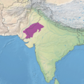
The Thar Desert is located in the north-western part of the [[Indian subcontinent]] stretching across the border between India and Pakistan, and is the eastern most extension of the [[Sahara desert|Sahara]]–[[Arabian desert]] formation.<ref name="Mares"/><ref name="Springer">{{cite book|title=The Indian Paleogene|year=2018|isbn=978-3-31977-443-5|publisher=[[Springer Publishing]]|editor1=Satish C. Tripathi|editor2=Sunil Bajpai|editor3=Vandana Prasad|pages=152-154}}</ref> It is spread across an area of {{cvt|264091|km2}}, with {{cvt|195091|km2}} of the desert area lying in India, with the remaining in Pakistan. The desert forms about six percent of the geographical area of India, with majority of the desert lying in the state of [[Rajasthan]], with portions extending into [[Gujarat]], [[Haryana]], and [[Punjab, India|Punjab]].<ref name="Mares"/><ref name="Springer"/> Towards the west, it extends into the provinces of [[Sindh]] and [[Punjab, Pakistan|Punjab]] in Pakistan.<ref name="Mares"/><ref>{{cite book |last1=Sharma |first1=K. K. |first2=S. P. |last2=Mehra |title=Faunal Ecology and Conservation of the Great Indian Desert |year=2009 |chapter=The Thar of Rajasthan (India): Ecology and Conservation of a Desert Ecosystem |editor-last=Sivaperuman |editor1-first=C. |editor2-last=Baqri |editor2-first=Q. H. |editor3-last=Ramaswamy |editor3-first=G. |editor4-last=Naseema |editor4-first=M. |publisher=[[Springer Publishing]] |location=Berlin Heidelberg |pages=1–11 |doi=10.1007/978-3-540-87409-6_1 |isbn=978-3-540-87408-9 }}</ref> The northeastern part of the Thar Desert lies between the [[Aravalli Hills]], which separates the same from the [[Central Highlands (India)|Central highlands]] and the [[Indo-Gangetic Plain]] to the east. The desert stretches from the alluvial plains of the [[Indus River]] in the west and northwest, to the [[Great Rann of Kutch]] in the south.<ref name="Mares"/> | |||
[[ | |||
== Origin and formation == | |||
{{anchor|Ice|Tibet}} | |||
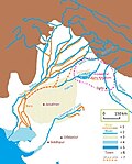
=== | [[File:Sarasvati river.jpg|thumb|upright=0.85|[[Vedic period|Vedic]] and present-day course of [[Ghaggar-Hakra River]] as proposed by {{harvtxt|Clift et al.|2012}} and {{harvtxt|Khonde et al.|2017}}.<br/> | ||
1 = ancient river; 2 = today's river; 3 = Thar desert; 4 = ancient shore; 5 = today's shore; 6 = today's settlements; 7 = dried-up [[Indus Valley civilisation|Harappan]] Hakkra course, and pre-Harappan [[Sutlej]] paleochannels]] | |||
In the [[Mesozoic era]] (252 to 66 [[million years ago|mya]]), the area was a low lying [[peneplain]], covered by shallow waters. [[Erosion]] resulted in the formation of three layers of [[planation surface]]s during the post-Mesozoic (66 to 2.6 mya), and early [[Pleistocene]] (2.6 mya to 11,000 years ago) periods. As the [[Himalayas]] arose during the mid-[[Miocene]] period (23.4 to 5.3 mya), it gave rise to the [[monsoon]].<ref name="Springer"/> | |||
During the [[Last Glacial Maximum]] (26,000–20,000 years ago), an estimated {{cvt|2400000|km2}} [[ice sheet]] covered the [[Tibetan Plateau]].<ref>{{cite journal|first=Matthias|last=Kuhle|year=1998|title=Reconstruction of the 2.4 million km<sup>2</sup> Late Pleistocene Ice Sheet on the Tibetan Plateau and its Impact on the Global Climate|journal=Quaternary International|volume=45/46|pages=71–108|doi=10.1016/S1040-6182(97)00008-6|bibcode=1998QuInt..45...71K}}</ref><ref>{{cite book|last=Kuhle|first=M|year=2004|chapter=The High Glacial (Last Ice Age and LGM) ice cover in High and Central Asia|title=Development in Quaternary Science 2c (Quaternary Glaciation – Extent and Chronology, Part III: South America, Asia, Africa, Australia, Antarctica)|editor1-last=Ehlers|editor1-first=J.|editor2-last=Gibbard|editor2-first=P.L.|pages=175–99}}</ref><ref name=K1999>{{cite journal|last=Kuhle|first=M.|year=1999|journal=GeoJournal|volume=47|issue=1–2|title=Tibet and High Asia V. Results of Investigations into High Mountain Geomorphology, Paleo-Glaciology and Climatology of the Pleistocene|pages=3–276|doi=10.1023/A:1007039510460| s2cid=128089823}}</ref> The low [[latitude]] ice sheet significantly affected [[radiative forcing]], and reflected at least four times more [[solar radiation]] per unit area into space than ice at higher latitudes, resulting in further cooling of the overlying atmosphere during that period.<ref>{{cite journal|last=Kuhle|first=M.|year=1988|title=The Pleistocene Glaciation of Tibet and the Onset of Ice Ages – An Autocycle Hypothesis|journal=GeoJournal|volume=17|issue=4|id=Tibet and High-Asia I. Results of the Sino-German Joint Expeditions (I)|pages=581–96|doi=10.1007/BF00209444| s2cid=129234912 }}</ref> Without the [[thermal low]] pressure caused by the heating, there was no monsoon over the [[Indian subcontinent]]. This lack of monsoon caused [[pluvial|extensive rainfall]] over the Sahara region, while resulted in more dust deposited towards the [[Arabian Sea]] in the east. It also resulted in changes to the [[life zone|biotic life zones]] on the Indian subcontinent, as fauna responded to this shift in climate with species like [[Javan rusa]] deer migrating into India.<ref>{{cite journal|first=Matthias|last=Kuhle|year=2001|title=The Tibetan Ice Sheet; its Impact on the Palaeomonsoon and Relation to the Earth's Orbital Variations|journal=Polarforschung|volume=71|pages=1–13|issue=1/2}}</ref> | |||
[[ | |||
{{anchor|Sarasvati|Saraswati|IVC}} | |||
== | The [[Aravalli Range]] formed rapidly, and reached significant altitude during the early [[Holocene]] period (11,700 years ago).<ref name="Springer"/> Between 10,000 and 8,000 years ago, a channel of the [[Ghaggar-Hakra River]], identified with the paleo [[Sarasvati River]], after its confluence with the [[Sutlej River]] flowed into the [[Nara Canal|Nara River]], a [[distributary|delta channel]] of the [[Indus River]], but then changed its course. The upliftment of the Aravallis brought about changes in the hydrography of the region, with increase in waters flowing through the [[Yamuna River]], while depriving the headwaters of the Ghaggar-Hakra system.<ref name="Springer"/> This left the Ghaggar-Hakra as a system of monsoon-fed rivers that no longer reached the sea, which ended up in the Thar desert.{{sfn|Giosan et al.|2012}}{{sfn|Maemoku|Shitaoka|Nagatomo|Yagi|2013}}{{sfn|Clift et al.|2012}}{{sfn|Singh et al.|2017}} Starting from around 4,500 to 5,000 years ago, when the monsoons that fed the river system diminished further, as the Aravallis blocked the monsoon winds from the east, the region became [[aridification|increasingly arid]]. The [[Indus Valley Civilisation]] had prospered in the area,{{sfn|Giosan et al.|2012}}{{sfn|Clift et al.|2012}}{{sfn|Singh et al.|2017}}{{refn|group=lower-alpha|In contrast to the mainstream view, {{harvtxt|Chatterjee|Ray|Shukla|Pande|2019}} suggest that the river remained perennial till 4,500 years ago.}} with several settlements along the course of the river system.{{sfn|Sankaran|1999}}<ref>{{cite web|url=http://pib.nic.in/newsite/erelcontent.aspx?relid=94098|title=Mythical Saraswati River|work=[[Press Information Bureau]]|date=20 March 2013|archive-url=https://web.archive.org/web/20161009182551/http://pib.nic.in/newsite/erelcontent.aspx?relid=94098 |archive-date=9 October 2016}}</ref> When monsoons diminished even further, the dried-up Hakra became an intermittent river, and the urban Harappan civilisation declined, becoming localized in smaller agricultural communities.{{sfn|Giosan et al.|2012}}{{refn|group=lower-alpha|name="Giosan"|{{harvtxt|Giosan et al.|2012}}: | ||
* "Contrary to earlier assumptions that a large glacier-fed Himalayan river, identified by some with the mythical Sarasvati, watered the Harappan heartland on the interfluve between the Indus and Ganges basins, we show that only monsoonal-fed rivers were active there during the Holocene." | |||
* "Numerous speculations have advanced the idea that the Ghaggar-Hakra fluvial system, at times identified with the lost mythical river of Sarasvati (e.g., 4, 5, 7, 19), was a large glacier fed Himalayan river. Potential sources for this river include the Yamuna River, the Sutlej River, or both rivers. However, the lack of large-scale incision on the interfluve demonstrates that large, glacier-fed rivers did not flow across the Ghaggar-Hakra region during the Holocene | |||
* "The present Ghaggar-Hakra valley and its tributary rivers are currently dry or have seasonal flows. Yet rivers were undoubtedly active in this region during the Urban Harappan Phase. We recovered sandy fluvial deposits approximately 5;400 y old at Fort Abbas in Pakistan (SI Text), and recent work (33) on the upper Ghaggar-Hakra interfluve in India also documented Holocene channel sands that are approximately 4;300 y old. On the upper interfluve, fine-grained floodplain deposition continued until the end of the Late Harappan Phase, as recent as 2,900 y ago (33) (Fig. 2B). This widespread fluvial redistribution of sediment suggests that reliable monsoon rains were able to sustain perennial rivers earlier during the Holocene and explains why Harappan settlements flourished along the entire Ghaggar-Hakra system without access to a glacier-fed river." | |||
{{harvtxt|Valdiya|2013}} dispute this, arguing that it was a large perennial river draining the high mountains as late as 3700–2500 years ago. {{harvtxt|Giosan|Clift|Macklin|Fuller|2013}} have responded to, and rejected, Valdiya's arguments.}}{{sfn|Clift et al.|2012}}{{sfn|Maemoku|Shitaoka|Nagatomo|Yagi|2013}}{{sfn|Singh et al.|2017}} Over the years, sand accumulated due to wind blown [[sediment]]s from the alluvial plains and the coast.<ref name="Springer"/> | |||
== | == Topography and geology == | ||
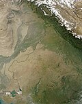
[[File:Thar Desert satellite.jpg|thumb|upright|Topography map of Thar Desert]] | |||
The eastern part of the Thar Desert, that lies in the western foothills of the Aravallis, consists of sandy plains intercepted by eroded hills of low elevation. It rises to about {{cvt|325|m}} in elevations as it reaches the Aravallis, which continue as the plateau of the central India beyond the range. The sandy plains extend across to the west, with the altitude dropping to {{cvt|150|m}} at the [[India-Pakistan border]].<ref name="Mares"/> Much of the desert area is covered by [[sand dunes]] that are formed due to accumulation of wind blown sand deposited over the [[sediment]]s from the alluvial plains. The sand is highly mobile due to the strong winds that rise each year before the onset of the monsoon.<ref>{{cite book |last=Laity |first=J. J. |year=2009 |url=https://books.google.com/books?id=wtAbzLLTcwcC&pg=PA30 |title=Deserts and Desert Environments |publisher=[[John Wiley & Sons]] |isbn=978-1-44430-074-1 |page=30 }}</ref><ref name="Geo">{{cite book|title=Records of the Geological Survey of India|volume=8-10|year=1875|publisher=[[Geological Survey of India]]|pages=19-20}}</ref> Much of the bedrock is composed of [[igneous]] and [[metamorphic]] rocks.<ref name="Mares"/> | |||
[[ | The geology of the region varies across its area. The oldest rocks are found in the [[Barmer district|Barmer]] region in the south, which are [[volcanic rocks]] composed of [[felsite]]. In the [[Pokhran]] area, there are various colored [[shales]], with varying hardness. Pale colored [[sandstones]] composed primarily of [[quartz]] are found south of [[Jodhpur]]. Sandstones with [[fossils]] belonging to the [[Jurassic]] period (201.4 to 143.1 mya) are found to the east of Balmer, and to the east and north of [[Jaisalmer]]. In the Jaisalmer region, the underlying sandstone beds are covered with layers of sandstone and [[limestone]], which also consist of numerous fossils, and are used extensively as building materials. Towards the west and north west of Jaisalmer, a tract of dark coloured sandstone rocks with [[calcium]], capped by red coloured red sandstone layer, and interspersed with yellow [[ammonite]] rocks.<ref name="Geo"/> | ||
[[ | |||
== Climate and hydrography == | |||
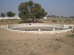
[[File:Johad.JPG|thumb|A [[taanka]] used to store rainwater]] | |||
The [[ | The region has a [[desert climate]]. In the summer months of April to June, average maximum temperature ranges {{cvt|40-42|C}} with average minimum of {{cvt|23-27|C}}. The maximum temperature often reaches above {{cvt|50|C}} during the peak summer. In the winter months of December to February, the minimum temperature reaches {{cvt|-2|C}}, with average maximum of {{cvt|18-24|C}} with average minimum of {{cvt|3.5-10|C}}.<ref name="Mares"/> The region receives most of the rainfall during the southwest monsoon from June to September.<ref name="Mares"/> Average annual rainfall ranges from {{cvt|100-300|mm}}, and occurs during the short July-to-September southwest monsoon.<ref name="Mares"/><ref name="Sinha1996">{{cite journal |last1=Sinha |first1=R. K. |last2=Bhatia |first2=S. |last3=Vishnoi |first3=R. |name-list-style=amp |year=1996 |title=Desertification control and rangeland management in the Thar desert of India |journal=RALA Report |pages=115–123 }}</ref> The distribution of rainfall also varies significantly across years.<ref name="Mares"/> The semi arid parts in the east have fewer sand dunes and receive slightly more precipitation.<ref>{{cite book|author1=Sharma, K. K.|author2=S. Kulshreshtha|author3=A. R. Rahmani|year=2013|title=Faunal Heritage of Rajasthan, India: General Background and Ecology of Vertebrates|publisher=[[Springer Publishing]]}}</ref> | ||
[[ | The depth of the [[water table]] in the region varies between {{cvt|10-40|m}}, and the water is mostly [[brackish]].<ref name="Mares"/> The region is drained by a minor inland river system. [[Luni River]] is the longest and major river in the desert.<ref>{{cite journal|last1=Carling|first1=Paul A.|last2=Leclair|first2=Suzanne F.|date=2018-07-16|title=Alluvial stratification styles in a large, flash-flood influenced dryland river: The Luni River, Thar Desert, north-west India|journal=Sedimentology|volume=66|issue=1|pages=102–128|doi=10.1111/sed.12487|issn=0037-0746|doi-access=free}}</ref> Other minor rivers that form part of the Luni river system include [[Bandi River|Bandi]], [[Ghaggar River|Ghaggar]], [[Guhiya River|Guhiya]], [[Jawai River|Jawai]], [[Jojari River|Jojari]], [[Liladi River|Liladi]], and [[Sukri River|Sukri]] rivers.<ref>{{cite book |last1=Jain |first1=Sharad K. |url=https://books.google.com/books?id=ZKs1gBhJSWIC&q=Bandi&pg=PA747 |title=Hydrology and Water Resources of India |last2=Agarwal |first2=Pushpendra K. |last3=Singh |first3=Vijay P. |year=2007 |publisher=[[Springer Publishing]] |isbn=978-1-40205-180-7 |page=747}}</ref> There are numerous [[endorheic]] salt water lakes–[[Sambhar Lake|Sambhar]], [[Kharaghoda]], [[Didwana]], [[Pachpadra Lake|Pachpadra]], and [[Phalodi]]. These lakes accumulate water during the monsoon rains and often evaporate slowly during the dry season. The salt content of these lakes comes from the weathering of the surrounding rocks in the region.<ref>{{cite journal |last1=Ramesh |first1=R. |last2=Jani |first2=R. A. |last3=Bhushan |first3=R. |name-list-style=amp |year=1993 |title=Stable isotopic evidence for the origin of salt lakes in the Thar desert |journal=Journal of Arid Environments |volume=25 |issue=1 |pages=117–123 |doi=10.1006/jare.1993.1047 |bibcode=1993JArEn..25..117R }}</ref> The {{cvt|649|km}}-long [[Indira Gandhi Canal]], which channels water from the [[Indus River]] system, is a major source for [[irrigation]] and [[drinking water]].<ref>{{cite web|url=https://www.britannica.com/place/Indira-Gandhi-Canal|title=Indira Gandhi Canal|work=[[Britannica]]|access-date=1 June 2025}}</ref> Water reservoirs known as tobas, [[johad]]s and [[taanka]]s are used to store rain water.<ref name="Mares"/><ref>{{cite web|author1=Amanda Suutari|author2=Gerry Marten|url=http://www.ecotippingpoints.org/our-stories/indepth/india-rajasthan-rainwater-harvest-restoration-groundwater-johad.html|title=Water Warriors: Rainwater Harvesting to Replenish Underground Water|date=June 2015|work=Eco tipping point|access-date=1 June 2017}}</ref><ref>{{cite journal|title=Rainwater harvesting in rural India - taankas in the Thar Desert|author=Megan Konar|author-link=Megan Konar|journal=Waterlines|volume=25|issue=4|date=April 2007|pages=22-24}}</ref> | ||
== | ==History== | ||
[[File: | [[File:Map of Vedic India.png|thumb|Thar Desert (orange) during [[Vedic Period]]]] | ||
The [[ | Lithic tools belonging to the prehistoric [[Aterian]] culture of the [[Maghreb]] from the [[Middle Paleolithic]] era have been found in the Thar Desert.<ref>{{cite book|last1=Gwen Robbins Schug, Subhash R. Walimbe|title=A Companion to South Asia in the Past|date=2016|publisher=John Wiley & Sons|page=64|url=https://books.google.com/books?id=7xv-CwAAQBAJ|isbn=978-1-11905-547-1|access-date=6 May 2016}}</ref> The [[Indus Valley Civilization]] flourished along the vicinity of the Ghaggar-Hakra River between 3300 BCE to 1300 BCE.<ref>{{cite journal |display-authors=4 |vauthors=Clift PD, Carter A, Giosan L, Durcan J, Duller GA, Macklin MG, Alizai A, Tabrez AR, Danish M, VanLaningham S, Fuller DQ |title=U-Pb zircon dating evidence for a Pleistocene Sarasvati River and capture of the Yamuna River |journal=Geology |volume=40|issue=3 |date=March 2012 |pages=211–214 |issn=0091-7613 |doi=10.1130/G32840.1 |bibcode=2012Geo....40..211C }}</ref><ref> {{cite book |last=Wright |first=Rita P. |author-link=Rita P. Wright |title=The Ancient Indus: Urbanism, Economy, and Society |url=https://books.google.com/books?id=gAgFPQAACAAJ |access-date=29 September 2013 |year=2009 |publisher=[[Cambridge University Press]] |isbn=978-0-521-57219-4 |page=1}}</ref> After the collapse of the Indus Valley Civilisation, which occurred around 1900 BCE, groups of [[Indo-Aryan peoples]] [[Indo-Aryan migrations|migrated into north-western India]] and started to inhabit the region.{{sfn|Witzel|1995|p=3}}{{sfn|Samuel|2010|p=41}} During the [[Vedic period]] (1500 BCE to 500 BCE), various [[Rigvedic tribes|tribes]] inhabited the region, and the [[Kuru kingdom]], the earliest Vedic state was formed by a super-tribe which joined several tribes in a new unit.<ref>{{cite book|last=Samuel |first=Geoffrey |year=2010 |title=The Origins of Yoga and Tantra. Indic Religions to the Thirteenth Century |publisher=[[Cambridge University Press]]|page=48-56}}</ref><ref>{{cite journal|last=Witzel |first=Michael |year=1995 |title=Early Sanskritization. Origins and Development of the Kuru State |journal=Electronic Journal of Vedic Studies |volume=1 |issue=4 |pages=1–26 |url=http://www.ejvs.laurasianacademy.com/ejvs0104/ejvs0104article.pdf |url-status=dead |archive-url=https://web.archive.org/web/20070611142934/http://www.ejvs.laurasianacademy.com/ejvs0104/ejvs0104article.pdf |archive-date=11 June 2007}}</ref> Prior to the "second urbanisation" that occurred in the Indo-Gangetic Plains, small settlements of the [[Painted Grey Ware culture]] arose in the Ghaggar-Hakra valley.<ref>{{cite book|last=Heitzman|first=James|date=31 March 2008|title=The City in South Asia|publisher=[[Routledge]]|isbn=978-1-134-28963-9|url=https://archive.org/details/cityinsouthasia0000heit|url-access=registration|pages=[https://archive.org/details/cityinsouthasia0000heit/page/12 12]–13}}</ref> | ||
== | By the third century BCE, a large part of the Indian subcontinent was under the control of the [[Mauryan Empire]], including portions of the desert.<ref>{{cite book|last=Thapar|first=Romila|author-link=Romila Thapar|year=1977|title=A History of India. Volume One|publisher=[[Penguin Books]]|page=78}}</ref> The [[Kushan Empire]] expanded out of what is now Afghanistan into the northwest of the Indian subcontinent in the middle of the 1st century CE.<ref>{{cite book|last1=Loewe|first1=Michael|last2=Shaughnessy|first2=Edward L.|author-link1=Michael Loewe|author-link2=Edward L. Shaughnessy|title=The Cambridge History of Ancient China: From the Origins of Civilization to 221 BC|url=https://books.google.com/books?id=cHA7Ey0-pbEC|year=1999|publisher=[[Cambridge University Press]]|isbn=978-0-52147-030-8|access-date=1 November 2013|pages=87–88}}</ref> The [[Gupta Empire]] flourished between the 2nd and 6th centuries CE, reaching its peak in the 5th century CE, when its territory incorporated the present Thar Desert region.<ref>{{cite encyclopedia |url=https://www.britannica.com/EBchecked/topic-art/285248/1960/The-Gupta-empire-at-the-end-of-the-4th-century |title=Gupta dynasty: empire in 4th century |encyclopedia=[[Britannica]] |access-date=16 May 2010 |archive-url=https://web.archive.org/web/20100330103811/https://www.britannica.com/EBchecked/topic-art/285248/1960/The-Gupta-empire-at-the-end-of-the-4th-century |archive-date=30 March 2010}}</ref> In the eastern part of the region, the [[Brahmin dynasty of Sindh|Brahmin dynasty]] ruled in the 7th to 8th centuries CE, which was later annexed to the [[Umayyad Caliphate]] in early 8th century CE, and the [[Abbasid Caliphate]] later.<ref>{{cite book|author=Nagendra Kumar Singh|title=Muslim Kingship in India|publisher=Anmol Publications|year=1999|isbn=978-8-126-10436-9|pages=43-45}}</ref><ref>{{cite book|author=Derryl N. Maclean|title=Religion and society in Arab Sindh|publisher=[[Brill Publishers]]|year=1989|isbn=978-9-004-08551-0|pages= 140-143}}</ref> The [[Pratihara dynasty]] ruled the eastern part of the region between the 8th and 11th centuries CE.<ref>{{cite book|title=A History of Rajasthan |first1=Rima |last1=Hooja |publisher=Rupa & Company |year=2006 |pages=274–278}}</ref> [[Mahmud of Ghazni]] annexed the region to the [[Ghaznavid]] Empire in the 11th century CE.<ref>{{cite book|url=https://books.google.com/books?id=K8kO4J3mXUAC&q=ghaznavid+mansura&pg=PA6 |title=Economic History of Medieval India, 1200-1500|last=Habib|first=Irfan|date=2011 |publisher=[[Pearson Education]]|isbn=978-8-131-72791-1|page=6}}</ref><ref>{{cite book|url=https://books.google.com/books?id=6lI9AAAAMAAJ&q=ghaznavid+mansura|title=An Observation: Perspective of Pakistan|last=Abdulla|first=Ahmed|date=1987|publisher=Tanzeem Publishers}}</ref> | ||
[[ | |||
[[File:Ecoregion_IM1304.png|thumb|Expanse of Thar Desert along the India-Pakistan border]] | |||
[[ | In the later [[Middle Ages]], the western part of the region was ruled by several [[Rajput states]]. These states started forming in the late 7th century CE, and rose to political prominence later.<ref>{{cite book|author=Hermann kulke|url=https://books.google.com/books?id=V73N8js5ZgAC|title=A History of India|date=2004|publisher=Psychology Press|isbn=978-0-415-32920-0|page=116}}</ref><ref>{{cite book|author=Alain Danielou|author-link=Alain Danielou|url=https://books.google.com/books?id=xlwoDwAAQBAJ|title=A Brief History of India|date=2003|publisher=Simon and Schuster|isbn=978-1-59477-794-3|page=87}}</ref><ref>{{cite book|author=Brajadulal Chattopadhyaya|url=https://books.google.com/books?id=21SgAAAAMAAJ|title=Studying Early India: Archaeology, Texts and Historical Issues|date=2006|publisher=Anthem|isbn=978-1-84331-132-4|page=116}}</ref><ref>{{cite book|author=Satish Chandra|author-link=Satish Chandra (historian)|url=https://books.google.com/books?id=XAkVclcWWeUC|title=Historiography, Religion, and State in Medieval India|date=1996|publisher=Har-Anand Publications|page=115}}</ref> The eastern part of the region was ruled by the [[Soomra dynasty|Soomras]],<ref>{{cite journal |last=Siddiqui |first=Habibullah |title=The Soomras of Sindh: their origin, main characteristics and rule – an overview (general survey) (1025–1351 CE) |url=http://www.uok.edu.pk/faculties/sindhi/docs/soomroEng.pdf |journal=Literary Conference on Soomra Period in Sindh |archive-date=3 June 2023 |access-date=4 August 2016 |archive-url=https://web.archive.org/web/20230603002419/https://uok.edu.pk/faculties/sindhi/docs/soomroEng.pdf |url-status=dead }}</ref><ref>{{cite journal |date=2007 |title=The Arab Conquest |journal=International Journal of Dravidian Linguistics |volume=36 |issue=1 |page=91}}</ref><ref>{{cite book |last=Dani |first=Ahmad Hasan |url=https://books.google.com/books?id=D_xtAAAAMAAJ&q=soomra+dynasty |title=History of Pakistan: Pakistan through ages |date=2007 |publisher=Sang-e Meel Publications |isbn=978-9-693-52020-0 |pages=218}}</ref> and the [[Samma (tribe)|Sammas]] from later 11th to early 16th century CE.<ref>{{cite book |author1=Census Organization (Pakistan) |url=https://books.google.com/books?id=63maAAAAIAAJ&q=yadav+rajputs |title=Population Census of Pakistan, 1972: Larkana |author2=Abdul Latif |publisher=Manager of Publications |year=1976}}</ref><ref>{{cite book |last1=Rapson |first1=Edward James |url=https://books.google.com/books?id=mBNZAAAAYAAJ&q=Samma+ |title=The Cambridge History of India: Turks and Afghans, edited by W. Haig |last2=Haig |first2=Sir Wolseley |last3=Burn |first3=Sir Richard |last4=Dodwell |first4=Henry |date=1965 |publisher=Chand |page=518}}</ref> The period was marked by the conflict between the [[Mughal Empire]] and the other dynasties that ruled the region. The conflict originated with the invasion by [[Timurid dynasty|Timurid]] king [[Babur]], which was resisted by the Rajput states under [[Rana Sanga]].<ref>{{cite book |last=Giles Tillotson |url=https://books.google.com/books?id=ApDrAAAAMAAJ |title=Mughal India |date=1991 |publisher=[[Penguin Books]] |isbn=978-0-14011-854-4 |page=4}}</ref> The conflicts continued for over 200 years, with the initial phase remaining indecisive. The Mughals gained an upper hand between the mid 15th and late 16th centuries, while the Rajputs retook control later after the Mughal empire began to collapse in the late 16th century.<ref>{{cite book |last=Sharma |first=G.N |url=https://books.google.com/books?id=jIs9AAAAMAAJ |title=Mewar and Mughal Emperors |date=1954 |publisher=S.L Aggarwal |page=42}}</ref><ref>{{cite book |last=Hooja |first=Rima |url=https://books.google.com/books?id=qqd1RAAACAAJ |title=A History of Rajasthan |date=2005 |publisher=Rupa and company |pages=530–532|isbn=978-8-12911-501-0 }}</ref> The [[Marathas]] took control over most of the region in the 18th century CE.<ref>{{cite book |last=Sen |first=S.N |url=https://books.google.com/books?id=bXWiACEwPR8C |title=An Advanced History of Modern India |date=2010 |publisher=Macmillan |page=11|isbn=978-0-230-32885-3 }}</ref> In 19th century CE, the region came under the suzerainty of the [[British Raj]], wherein it was composed of a large number of [[princely states]], with powers divided amongst the local rulers and the British.<ref>{{cite book|title=Imperial Gazetteer of India vol. IV|year=1907|page=60}}</ref> | ||
The [[partition of India]] resulted in the formation of the independent states of India and Pakistan, and the Thar Desert region was split between the two countries. It resulted in large scale conflicts, and mass migration of people across the borders.<ref>{{cite book| title=The idea of Pakistan | author=Stephen P. Cohen | author-link=Stephen P. Cohen | year=2004 | isbn=978-0-815-71502-3 | publisher=[[Brookings Institution]]| url=https://books.google.com/books?id=-78yjVybQfkC | page=212}}</ref><ref>{{cite book|url=https://books.google.com/books?id=ZdLhnFet4w4C&pg=PA39|title=Remembering Partition: Violence, Nationalism and History in India|last=Pandey|first=Gyanendra|publisher=[[Cambridge University Press]]|year=2001|isbn=978-0-521-00250-9|page=39|access-date=7 September 2017}}</ref><ref>{{cite journal|author1=Bharadwaj, Prasant|author2=Khwaja, Asim|author3=Mian, Atif|date=30 August 2008|title=The Big March: Migratory Flows after the Partition of India|journal=Economic & Political Weekly|volume=43}}</ref> After the [[Political integration of India]], and [[States Reorganisation Act, 1956|reorganisation]] of Indian states, majority of the eastern part of the desert became part of the [[Rajasthan]] state, with minor portions in [[Haryana]], [[Punjab, India|Punjab]], and [[Gujarat]].<ref name="Mares"/><ref name="Springer"/><ref>{{cite web |url=http://indiacode.nic.in/coiweb/amend/amend7.htm |title=Seventh Amendment |work=Indiacode |access-date=19 November 2011 |url-status=dead |archive-url=https://web.archive.org/web/20170501011646/http://indiacode.nic.in/coiweb/amend/amend7.htm |archive-date=1 May 2017}}</ref> The western third became part of the [[Sindh]] and [[Punjab, Pakistan|Punjab]] provinces in Pakistan.<ref name="Mares"/><ref name="Springer"/> In 1965 and 1971, further population exchanges took place in the Thar region between India and Pakistan; 3,500 people, mostly Muslims, moved from India to Pakistan, while thousands of Hindu families migrated from Pakistani to the Indian section.<ref>{{cite book|url=https://books.google.com/books?id=U7imPH4KVJUC&q=arif+hasan+thar+desert+migration&pg=PA15|title=Migration and Small Towns in Pakistan|last1=Hasan|first1=Arif|last2=Raza|first2=Mansoor|publisher=IIED|year=2009|isbn=978-1-843-69734-3|pages=15–16}}</ref><ref>{{cite web|url=http://himalmag.com/just-another-border/|title=Not just another border|last=Maini|first=Tridivesh Singh|date=15 August 2012|work=Himal South Asian}}</ref><ref>{{cite web|url=http://www.newslens.pk/families-separated-pak-india-border-yearn-see-loved-ones/|title=Families separated by Pak-India border yearn to see their loved ones|last=Arisar|first=Allah Bux|date=6 October 2015|work=News Lens Pakistan|access-date=25 December 2016|archive-date=25 December 2016|archive-url=https://web.archive.org/web/20161225150022/http://www.newslens.pk/families-separated-pak-india-border-yearn-see-loved-ones/|url-status=dead}}</ref> | |||
[[ | |||
==Demographics and economy == | |||
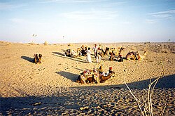
[[File:Désert-du-Thar.jpg|thumb|Desert tribes near [[Jaisalmer]]]] | |||
{{Main|Thar people}} | |||
[[ | The [[Thar people]] are the natives of the region.<ref>{{cite book |last1=Gambier |first1=Yves |last2=Stecconi |first2=Ubaldo |title=A World Atlas of Translation |date=15 February 2019 |publisher=John Benjamins Publishing Company |isbn=978-9-027-26296-7 |page=137 |url=https://books.google.com/books?id=5meEDwAAQBAJ&dq=Thari+language+in+rajasthan&pg=PA137 }}</ref><ref>{{cite book |last1=Frawley |first1=William J. |title=International Encyclopedia of Linguistics |date=1 May 2003 |publisher=Oxford University Press |isbn=978-0-199-77178-3 |page=291 |url=https://books.google.com/books?id=6ftQEAAAQBAJ&dq=Dhatki+language+in+India&pg=PA291 }}</ref> The Thar Desert is the most widely populated desert in the world, with a population density of 83 people per km<sup>2</sup>.<ref>{{cite report|editor=Singh, P|year=2007|url=http://planningcommission.nic.in/aboutus/committee/wrkgrp11/tf11_grass.pdf|title=Report of the Task Force on Grasslands and Deserts|archive-url=https://web.archive.org/web/20111210071534/http://planningcommission.nic.in/aboutus/committee/wrkgrp11/tf11_grass.pdf |archive-date=10 December 2011|publisher=[[Government of India]]}}</ref> The inhabitants are composed of various religions including [[Hindu]]s, and [[Muslim]]s, and belong to different ethnicities.<ref>{{cite web|url=https://scroll.in/article/856630/thar-desert-is-an-oasis-of-inter-religious-harmony-in-pakistan-it-must-not-be-destroyed|title=Thar desert is an oasis of inter-religious harmony in Pakistan. It must not be destroyed|date=7 November 2017|access-date=1 June 2025|work=Scroll.in}}</ref><ref>{{cite web|url=http://www.dawn.com/news/1167315|title=Mithi: Where a Hindu fasts and a Muslim does not slaughter cows|last=Raza|first=Hassan|date=5 March 2012|work=Dawn|access-date=1 June 2023}}</ref> The most spoken languages are [[Rajasthani languages]] such as [[Marwari language|Marwari]] in central and eastern regions, [[Sindhi language|Sindhi]] in the southwest, and [[Lahnda]] in the northwest region of the Thar.<ref name="Brit">{{cite web|url=https://www.britannica.com/place/Thar-Desert|title=Thar Desert|work=[[Britannica]]|access-date=1 June 2025}}</ref><ref>{{cite report|url=http://www.censusindia.gov.in/2011Census/C-16_25062018_NEW.pdf|title=Census Data 2011|publisher=[[Government of India]] |access-date=11 December 2014}}</ref> | ||
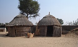
[[File:House in the Thar.JPG|thumb|Huts in the Thar Desert]] | |||
[[File: | |||
Majority of the people live in rural nomadic communities in the harsh environment of the Thar Desert.<ref name="Brit"/> People live in small huts which are shaped like a cylindrical [[bee hive]] topped by a conical thatched roof.<ref name="People">{{cite book|title=Sindhi Society and Culture|author=Ghulam Ali|year=2010|publisher=Culture Department, Government of Sindh|page=183}}</ref> The huts are distributed in small randomly formed clusters, while carefully planned for privacy so that the entrances of adjacent huts never face each other.<ref>{{cite book|title=Traditional Buildings: A Global Survey of Structural Forms and Cultural Functions|author=Allen Noble|year=2009|isbn=978-0-857-73902-5|publisher=[[Bloomsbury Publishing]]|page=273}}</ref> [[Middle class]] people in permanent settlements live in single-storeyed dwellings with large rectangular courtyards, and wide [[verandah]]s. It is supported by [[timber]] made from local wood and plastered on the upper side with a type of clay.<ref>{{cite web|url=https://wzccindia.com/sam-hut-thar-desert-rajasthan/#|title=Sam hut|work=[[Government of India]]|access-date=1 June 2025}}</ref> The wood of ''[[Prosopis cineraria]]'' (khejri) provides high-quality fuel wood, and building material. Its roots also encourage [[nitrogen]] fixation, which produces higher crop yields.<ref>{{cite web|url=http://www.ecoworld.com/Home/Articles2.cfm?TID=341|title=Arid Agriculture: State-of-the-Art Agro-Forestry vs. Deserts on the March|archive-url=https://web.archive.org/web/20061219083939/http://www.ecoworld.com/Home/Articles2.cfm?TID=341 |archive-date=19 December 2006 |work=Eco World |date=14 August 2003|access-date=1 June 2012}}</ref> | |||
=== | Water scarcity remains the major problem in the desert with dependence on temporary storage of rain water, and prolonged periods of drought.<ref>{{cite book|title=Dry: Life Without Water|author1=Ehsan Masood|author2=Daniel Schaffer|year=2006|isbn=978-0-674-02224-9|publisher=[[Harvard University Press]]|pages=82=83}}</ref> Villages often consists of a few water sources such as temporary wells, and storage ponds.<ref name="People"/> The people spend a considerable amount of time fetching water for themselves or their animals.<ref>{{cite book |last1=Mohammad Aslam Uqaili |first1=Mohammad Aslam |last2=Khanji |first2=Harijan |title=Energy, Environment and Sustainable Development |date=2011 |page=145 |isbn=9783709101094 |url=https://books.google.com/books?id=rndnOvfTDW4C&dq=thari+people&pg=PA145}}</ref> The Thar desert region has offered suffered from poor development due to the harsh environment and access to outside world.<ref>{{cite journal |last1=Parwani |first1=Lalchand |title=Life Style of Thar Problems and opportunities in 21st century |journal=University of Sindh, Jamshoro |url=https://www.academia.edu/30945006}}</ref> | ||
[[ | |||
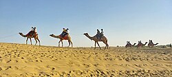
[[File:Camel_rides_in_Jaisalmer,_Thar_Desert_15.jpg|thumb|[[Camel]] rides in the desert]] | |||
[[File: | |||
< | Most of the people are involved in herding animals, limited [[agriculture]], and in handicrafts.<ref>{{cite journal|last1=Nasim |first1=S |title=Thar|journal=Developing teachers' skills in Thar desert area, Sindh, Pakistan |date=2007 |url=https://ecommons.aku.edu/cgi/viewcontent.cgi?article=1108&context=book_chapters }}</ref><ref>{{cite web | url=https://www.dawn.com/news/1393111 | title=Culture: Shawl Weavers of Thar | date=4 March 2018 |access-date=1 June 2020}}</ref><ref>{{cite news |last1=Raza |first1=Fawwad |title=Modern Agriculture Techniques in the Desert of Thar |work=Scientia Magazine |url=https://scientiamag.org/modern-agriculture-techniques-in-the-desert-of-thar/ |access-date=1 November 2024 |date=31 March 2021}}</ref> Agriculture happens in specifc areas supplanted by stored water, or irrigation from canals. Khadins are special crop enbankments which prevent water run off and used for agriculture. Drought resistant varieties of [[green gram]], [[sesame]], [[millets]], [[cluster beans]], [[chickpea]], and [[jowar]] are grown in the region. Shrubs like [[melon]], [[cucumber]], [[citrus fruits]], and [[date palms]], are grown near water bodies.<ref>{{cite web|url=https://agroecologyfund.org/food-security-and-drought-mitigation-in-indias-thar-desert/|title=Food and drought mitigation in Thar desert|work=Agro ecology|access-date=1 June 2025}}</ref> The Thar region is a major [[opium]] production and consumption area.<ref>{{cite web |url=https://main.icmr.nic.in/sites/default/files/icmr_bulletins/bulljan-mar08.pdf |title=ICMR Bulletin vol.38, No.1-3, Pattern and Process of Drug and Alcohol Use in India |access-date=10 May 2022 |archive-url=https://web.archive.org/web/20220328054240/https://main.icmr.nic.in/sites/default/files/icmr_bulletins/bulljan-mar08.pdf |archive-date=28 March 2022}}</ref><ref>{{cite web |url=https://www.indiatoday.in/india/video/will-rajasthan-opium-farmers-vote-for-change-1401355-2018-12-03 |title=Will Rajasthan opium farmers vote for change? |access-date=10 May 2022 |archive-url=https://web.archive.org/web/20220510113738/https://www.indiatoday.in/india/video/will-rajasthan-opium-farmers-vote-for-change-1401355-2018-12-03 |archive-date=10 May 2022}}</ref> The [[Tharparkar cattle|Thari]] cow breed originated from [[Tharparkar District|Tharparkar]].<ref>{{Cite web|url=http://afs.okstate.edu/breeds/cattle/tharparkar|title=Breeds of Livestock - Tharparkar Cattle — Breeds of Livestock, Department of Animal Science|work=[[Oklahoma State University]]|access-date=5 August 2019}}</ref> | ||
The [[Government of India]] initiated departmental exploration for oil in 1955 and 1956 in the area,<ref>{{Cite web |url=http://planningcommission.nic.in/plans/planrel/fiveyr/2nd/2planch18.html |title=Planning Commission plans|access-date=16 November 2009 |archive-url=https://web.archive.org/web/20060414235126/http://planningcommission.nic.in/plans/planrel/fiveyr/2nd/2planch18.html |archive-date=14 April 2006 |url-status=dead}}</ref> and [[natural gas]] was discovered in 1988 in the [[Jaisalmer basin]].<ref>{{cite web|url=http://oilindia.nic.in/ourcomp_spread_rajasthan.htm |title=Spread in Rajasthan|work=Oil India|archive-url=https://web.archive.org/web/20060630062216/http://oilindia.nic.in/ourcomp_spread_rajasthan.htm |archive-date=30 June 2006}}</ref> The region is also home to several [[solar energy]] generation units, such as the [[Bhadla Solar Park]], with a generation capacity of over 2 gigawatts.<ref>{{cite web |title=Soaking Up Sun in the Thar Desert |url=https://earthobservatory.nasa.gov/images/149442/soaking-up-sun-in-the-thar-desert |work=[[NASA]] | access-date=1 June 2025 |date=19 February 2022}}</ref> [[Desert safari]] on [[camels]] have become increasingly popular with tourists frequenting the desert seeking adventure on camels, resulting in the development of the [[ecotourism]] industry.<ref>{{cite web|url=https://www.hindustantimes.com/lifestyle/travel/pushkar-fair-where-camels-culture-and-tourists-come-together-in-the-heart-of-rajasthan-101731674766993.html|title=Pushkar Fair: Where camels, culture and tourists come together in the heart of Rajasthan|work=[[The Hindustan Times]]|date=15 November 2024|access-date=1 June 2025}}</ref> | |||
[[ | |||
=== | ==Biodiversity== | ||
=== Vegetation === | |||
[[File: | [[File:Khejri.jpg|thumb|''[[Prosopis cineraria]]'' tree]] | ||
=== | The natural vegetation of the dry area is classified as [[northwestern thorn scrub forest]], which consist of small, loosely-scattered patches of greenery.<ref>{{cite book |last1=Champion |first1=H. G. |first2=S. K. |last2=Seth |year=1968 |title=A revised survey of the forest types of India |publisher=Government of India Press |oclc=549213 }}</ref><ref>{{cite book |last=Negi |first=S. S. |year=1996 |url=https://books.google.com/books?id=ZrP3-4IFtMUC&pg=PA182 |title=Biosphere Reserves in India: Landuse, Biodiversity and Conservation |publisher=Indus Publishing Company |location=Delhi |isbn=978-8-17387-043-9 }}</ref> The densities and sizes of these green patches increase from west to east, aligning with the pattern of increase in rainfall. There are 168 plant species belonging to 48 families reported from the area.<ref name="UNESCO">{{cite web|url=https://whc.unesco.org/en/tentativelists/5448/#:~:text=**Species**:%20*%20**Reptiles**%20Laungwala%20Toad%2Dheaded%20Agama%2C%20Sindh,Hairy%2Dfooted%20Gerbil%2C%20Desert%20hare%2C%20and%20Long%2Deared%20hedgehog|title=Desert National Park|work=[[UNESCO]]|access-date=1 June 2025}}</ref> Some species of trees grow in low-lying areas of the desert.<ref name="Mares"/> Other vegetation consists of [[shrub]]s, and [[perennial]] herbs.<ref name="Kaul">{{cite book |last=Kaul |first=R. N. |year=1970 |title=Afforestation in arid zones |series=Monographiiae Biologicae |volume=20 |location=The Hague |oclc=115047 }}</ref> The [[endemic]] floral species include ''[[Calligonum polygonoides]]'', ''[[Prosopis cineraria]]'', ''[[Acacia nilotica]]'', ''[[Tamarix aphylla]]'', and ''[[Cenchrus biflorus]]''.<ref>{{cite journal |last1=Khan |first1=T. I. |last2=Frost |first2=S. |name-list-style=amp |year=2001 |title=Floral biodiversity: a question of survival in the Indian Thar Desert |journal=Environmentalist |volume=21 |issue=3 |pages=231–236 |doi=10.1023/A:1017991606974 |s2cid=82472637 }}</ref> Plant species include ''[[Aerva javanica]]'', ''[[Balanites roxburghii]]'', ''[[Calotropis procera]]'', ''[[Capparis decidua]]'', ''[[Clerodendrum multiflorum]]'', ''[[Commiphora mukul]]'', | ||
''[[Commiphora wightii]]'', ''[[Cordia sinensis]]'', ''[[Crotalaria burhia]]'', ''[[Ephedra foliata]]'', ''[[Euphorbia caducifolia]]'', ''[[Euphorbia neriifolia]]'', ''[[Grewia tenax]]'', ''[[Leptadenia pyrotechnica]]'', ''[[Lycium barbarum]]'', ''[[Maytenus|Maytenus emarginata]]'', ''[[Mimosa hamata]]'', ''[[Suaeda fruticosa]]'', ''[[Vachellia jacquemontii]]'', ''[[Ziziphus nummularia]]'' and ''[[Ziziphus zizyphus]]''.<ref name="UNESCO"/><ref name="Kaul"/> Herbs and grasses include ''[[Cenchrus biflorus]]'', ''[[Cenchrus ciliaris]]'', ''[[Citrullus colocynthis]]'' ''[[Cenchrus setiger]]'', ''[[Cynodon dactylon]]'', ''[[Dactyloctenium|Dactyloctenium scindicum]]'', ''[[Desmostachya bipinnata]]'', ''[[Lasiurus scindicus]]'', ''[[Ochthochloa|Ochthochloa compressa]]'', ''[[Panicum turgidum]]'', ''[[Panicum antidotale]]'', ''[[Dichanthium annulatum]]'', ''[[Sorghum halepense]]'', ''[[Sporobolus|Sporobolus marginatus]]'', ''[[Saccharum spontaneum]]'', ''[[Tribulus terrestris]]'', and species of ''[[Eragrostis]]'', ''[[Phragmites]]'', and ''[[Typha]]''.<ref name="Kaul"/> | |||
The soil of the Thar Desert remains dry for much of the year, so it is prone to [[wind erosion]]. High-velocity winds blow soil from the desert, depositing some of it on neighboring fertile lands, and causing sand dunes within the desert to shift. To counteract this problem, sand dunes are stabilised by erecting micro [[windbreak]] barriers with scrub material and then by [[afforestation]] of the treated dunes by planting the seedlings of shrubs such as ''[[Calligonum polygonoides]]'', ''[[Cassia auriculata]]'', and ''[[Ricinus communis]]'', and trees such as ''[[Acacia senegal]]'', ''[[Prosopis juliflora]]'', and ''[[Albizzia lebbeck]]''.<ref name="Sinha1996"/> | |||
== | === Fauna === | ||
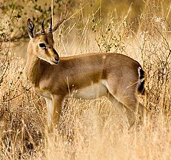
[[File:Chinkara.jpg|thumb|[[Chinkara]] found in the Thar Desert]] | |||
[[ | The fauna of Thar has characteristics of both [[Mesic habitat|mesic]] and desert habitats. About 60 species of [[mammals]], 51 species of [[reptiles]], and eight [[amphibian]] species have been reported from the desert. About 69% of the [[herpetofauna]] and 54% of mammalian fauna are affiliated with the Sahara region.<ref name="UNESCO"/> Important mammal species include [[Chinkara]], [[Vulpes vulpes|Desert fox]], [[Vulpes bengalensis|Indian fox]], [[Felis silvestris|Desert Cat]], [[Gerbillus gleadowi|Hairy-footed Gerbil]], [[Desert hare]], and [[Long-eared hedgehog]] Hemeichinus auritus.<ref name="UNESCO"/><ref name="Ani">{{cite web|url=https://www.sciencing.com/animals-thar-desert-5365810/|title=Animals of the Thar desert|work=Sciencing|access-date=1 June 2025}}</ref> | ||
Reptilian species include 14 species of [[lizards]] and seven species of [[snakes]]. Endemic reptile species of the Thar Desert include [[Rajasthan toad-headed lizard]], and [[Lytorhynchus paradoxus|Sindh awl-headed snake]]. Other species of reptiles include [[Uromastyx hardwickii|Indian spiny-tailed lizard]], [[Dwarf gecko]], [[Persian gecko]], [[Desert monitor]], and [[Saw-scaled viper]].<ref name="UNESCO"/> In 2023, fossil remains of ''[[Tharosaurus indicus]]'', a new species of [[sauropod]] dinosaur was found in the Thar Desert. It was discovered in the outcrops belonging to the [[Jaisalmer Formation]], dating to the [[Bathonian]] age of the [[Middle Jurassic]] era.<ref name="Tharosaurus">{{Cite journal |last1=Bajpai |first1=S. |last2=Datta |first2=D. |last3=Pandey |first3=P. |last4=Ghosh |first4=T. |last5=Kumar |first5=K. |last6=Bhattacharya |first6=D. |year=2023 |title=Fossils of the oldest diplodocoid dinosaur suggest India was a major centre for neosauropod radiation |journal=Scientific Reports |volume=13 |issue=1 |at=12680 |doi=10.1038/s41598-023-39759-2 |pmid=37542094 |pmc=10403599 |bibcode=2023NatSR..1312680B |doi-access=free }}</ref> | |||
More than 100 bird species of [[Bird migration|migratory]] and resident desert birds, are found in the desert. Significant bird species include the [[endangered species|endangered]] [[Gyps bengalensis|Oriental white-backed vulture]], and [[Gyps indicus|Indian vulture]], [[Saxicola macrorhyncha|White-browed bushchat]], [[Amandava formosa|Green munia]], and the visiting [[Houbara bustard]].<ref name="UNESCO"/> The [[Great Indian Bustard]], classified as [[critically endangered]], and one of the world’s heaviest flying birds, inhabits the open shrub lands of the desert.<ref name="Ani"/><ref>{{cite journal|title=Status, threats and conservation of the Great Indian Bustard ''Ardeotis nigriceps'' (Vigors) in Pakistan |author=Khan, A.A. |author2=Khaliq, I. |author3=Choudhry, M.J.I. |author4=Farooq, A. |author5=Hussain, N. |name-list-style=amp |journal=Current Science |volume=95 |issue=8 |year=2008 |pages=1079–1082 |archive-date=2011-06-05 |url=http://www.ias.ac.in/currsci/oct252008/1079.pdf |archive-url=https://web.archive.org/web/20110605032723/http://www.ias.ac.in/currsci/oct252008/1079.pdf}}</ref> The [[Indian peafowl]] is a resident breeder in the Thar region, and has adapted to the desert ecosystem.<ref>{{cite web|url=https://www.cabidigitallibrary.org/doi/full/10.5555/19822612007|title=Adaptations and commensality of the peafowl|author=I K Sharma|access-date=1 June 2025}}</ref> | |||
=== | ===Protected areas=== | ||
[[ | There are several [[protected area]]s in the Thar Desert: | ||
[[ | * '''In India''': | ||
1 = | ** [[Desert National Park]] in Rajasthan covers {{cvt|3162|km2}},<ref>{{cite journal |last=Rahmani |first=A. R. |year=1989 |title=The uncertain future of the Desert National Park in Rajasthan, India |journal=Environmental Conservation |volume=16 |issue=3 |pages=237–244 |doi=10.1017/S0376892900009322 |s2cid=83995201 }}</ref> The [[Akal Wood Fossil Park]] forms part of the protected area.<ref name=Singh2007>{{cite web|author=Singh, P|year=2007|url=http://planningcommission.nic.in/aboutus/committee/wrkgrp11/tf11_grass.pdf|title=Report of the Task Force on Grasslands and Deserts|archive-url=https://web.archive.org/web/20111210071534/http://planningcommission.nic.in/aboutus/committee/wrkgrp11/tf11_grass.pdf |archive-date=10 December 2011|work=[[Government of India]]}}</ref> | ||
** [[Tal Chhapar Sanctuary]] covers {{cvt|7|km2}} and is an [[Important Bird Area]] located in the [[Churu district]], in Rajasthan.<ref name=Singh2007/> | |||
3 = | ** [[Sundha Mata conservation reserve]] covers {{cvt|117.49|km2}} and is located in the [[Jalore District]] of Rajasthan.<ref>{{cite web|work=[[Wildlife Institute of India]] |date=2015 |url=http://www.wii.gov.in/nwdc_conservation_reserves |title=Conservation Reserves |archive-url=https://web.archive.org/web/20150410212243/http://www.wii.gov.in/nwdc_conservation_reserves |archive-date=10 April 2015 }}</ref> | ||
* '''In Pakistan''': | |||
** [[Lal Suhanra National Park|Lal Suhanra Biosphere Reserve and National Park]] is a [[UNESCO]] declared biosphere reserve, which covers {{cvt|65,791|ha}} the [[Cholistan Desert|Cholistan]] region of the Thar Desert.<ref>{{cite web|url=http://www.unesco.org/mabdb/br/brdir/directory/biores.asp?mode=all&code=PAK+01|title=UNESCO – MAB Biosphere Reserves Directory|work=[[UNESCO]]|access-date=21 April 2020}}</ref><ref>{{cite web|url=http://www.unesco.org/new/en/natural-sciences/environment/ecological-sciences/biosphere-reserves/asia-and-the-pacific/pakistan/lal-suhanra/|title=Lal Suhanra|work=[[UNESCO]]|access-date=28 December 2016}}</ref> | |||
** [[Nara Desert Wildlife Sanctuary]] covers {{cvt|6300|km2}}, and is located in [[Mirpurkhas District]].<ref>{{cite journal |last1=Ghalib |first1=S. A. |last2=Khan |first2=A. R. |last3=Zehra |first3=M. |last4=Abbas |first4=D. |display-authors=1 |year=2008 |title=Bioecology of Nara Desert Wildlife Sanctuary, Districts Ghotki, Sukkur and Khairpur, Sindh |journal=Pakistan Journal of Zoology |volume=40 |issue=1 |pages=37–43 |issn=0030-9923 }}</ref><ref>{{cite web|url=http://www.wildlifeofpakistan.com/sanctuaries.html|title=Protected Areas|access-date=21 April 2020|archive-date=3 February 2020|archive-url=https://web.archive.org/web/20200203175230/http://www.wildlifeofpakistan.com/sanctuaries.html|url-status=dead}}</ref> | |||
== See also == | == See also == | ||
* {{anl|Arid Forest Research Institute}} | |||
* {{anl|Cholistan Desert}} | |||
* {{anl|Nara Desert}} | |||
* {{anl|Great Rann of Kutch}} | |||
* {{anl|Teri (geology)}} | |||
== Notes == | |||
{{notelist}} | |||
== References == | == References == | ||
{{reflist| | {{reflist}} | ||
== Sources == | |||
* {{Cite journal | last1 =Chatterjee | first1 =Anirban|last2=Ray|first2=Jyotiranjan S.|last3=Shukla|first3=Anil D.|last4=Pande|first4=Kanchan|date=20 November 2019| title =On the existence of a perennial river in the Harappan heartland| journal=Scientific Reports |language=en |volume=9|issue=1 |pages=17221 |doi=10.1038/s41598-019-53489-4 |pmid=31748611 |pmc=6868222 |issn=2045-2322|bibcode=2019NatSR...917221C}} | |||
* {{citation | last1 =Clift | first1 =Peter D. | ref ={{sfnref|Clift et al.|2012}} | last2 =Carter | first2 =Andrew | last3 =Giosan | first3 =Liviu | last4 =Durcan | first4 =Julie | display-authors =etal | year =2012 | title =U-Pb zircon dating evidence for a Pleistocene Sarasvati River and capture of the Yamuna River | journal =Geology | volume =40 | issue =3 | pages =211–214 | doi =10.1130/g32840.1 | bibcode =2012Geo....40..211C | s2cid =130765891 }} | |||
* {{cite journal |last=Giosan | year =2012 | ref={{sfnref|Giosan et al.|2012}} | title =Fluvial landscapes of the Harappan civilization | journal =PNAS|volume= 109 |issue=26 |doi= 10.1073/pnas.1112743109 |pages=E1688–E1694 | display-authors =etal | pmid =22645375 | pmc=3387054 |bibcode=2012PNAS..109E1688G| doi-access =free }} | |||
* {{cite journal | last1 =Giosan | first1 =Liviu | last2 =Clift | first2 =Peter D. | last3 =Macklin | first3 =Mark G. | last4 =Fuller | first4 =Dorian Q. | title =Sarasvati II | journal =Current Science | date =10 October 2013 | volume =105 | issue =7 | pages =888–890 | jstor =24098502 | url =https://www.jstor.org/stable/24098502 }} | |||
* {{Citation | last1 =Khonde | first1 =Nitesh | last2 =Kumar Singh | first2 =Sunil | last3 =Maur | first3 =D. M. | last4 =Rai | first4 = Vinai K. | last5 =Chamyal | first5 =L. S. | last6 =Giosan | first6 =Liviu | year =2017 | title =Tracing the Vedic Saraswati River in the Great Rann of Kachchh | journal =Scientific Reports | volume =7 | issue =1 | page =5476 | doi =10.1038/s41598-017-05745-8 | pmid =28710495 | pmc =5511136 | bibcode =2017NatSR...7.5476K |ref={{sfnref|Khonde et al.|2017}}}} | |||
* {{cite book |last1=Maemoku |first1=Hideaki |last2=Shitaoka |first2=Yorinao |last3=Nagatomo |first3=Tsuneto |last4=Yagi |first4=Hiroshi |editor1=Giosan, Liviu |editor2=Fuller, Dorian Q. |editor3=Nicoll, Kathleen |editor4=Flad, Rowan K. |editor5=Clift, Peter D. |title=Climates, Landscapes, and Civilizations |chapter-url=https://books.google.com/books?id=D7aw5mfscBMC |series=American Geophysical Union Monograph Series 198 |year=2013 |publisher=John Wiley & Sons |isbn=978-1-118-70443-1 |chapter=Geomorphological Constraints on the Ghaggar River Regime During the Mature Harappan Period}} | |||
* {{cite journal |last=Sankaran |first=A. V. |title=Saraswati – The ancient river lost in the desert |journal=Current Science |volume=77 |number=8 |date=25 October 1999 |pages=1054–1060 |jstor=24103577 |url=http://www.iisc.ernet.in/currsci/oct25/articles20.htm |archive-url=https://web.archive.org/web/20040919123504/http://www.iisc.ernet.in/currsci/oct25/articles20.htm |archive-date=19 September 2004 }} | |||
* {{cite journal |last =Singh |first=Ajit |year=2017 |title=Counter-intuitive influence of Himalayan river morphodynamics on Indus Civilisation urban settlements |journal=Nature Communications |volume=8 |issue=1 |pages=1617 |doi=10.1038/s41467-017-01643-9 |pmid=29184098 |pmc=5705636 |bibcode=2017NatCo...8.1617S |display-authors=etal |ref={{sfnref|Singh et al.|2017}} }} | |||
* {{cite journal |last=Valdiya |first=K.S. |year=2013 |title=The River Saraswati was a Himalayan-born river |journal=Current Science |volume=104 |issue=1 |page=42 |url=http://www.currentscience.ac.in/Volumes/104/01/0042.pdf }} | |||
== Further reading == | == Further reading == | ||
<!-- these may have been used by editors as a bibliography --> | <!-- these may have been used by editors as a bibliography --> | ||
* Bakliwal, P. C. and Sharma, S. B. (1980). "On the migration of the river Yamuna". ''Journal of the Geological Society of India'', Vol. 21, Sept. 1980, pp. 461–463. | * Bakliwal, P. C. and Sharma, S. B. (1980). "On the migration of the river Yamuna". ''Journal of the Geological Society of India'', Vol. 21, Sept. 1980, pp. 461–463. | ||
* Bakliwal, P. C. and Grover, A. K. (1988). "Signature and migration of Sarasvati river in Thar desert, Western India". ''Record of the Geological Survey of India'' V 116, Pts. 3–8, pp. 77–86. | * Bakliwal, P. C. and Grover, A. K. (1988). "Signature and migration of Sarasvati river in Thar desert, Western India". ''Record of the Geological Survey of India'' V 116, Pts. 3–8, pp. 77–86. | ||
* Rajawat, A. S., Sastry, C. V. S. and Narain, A. (1999-a). "Application of pyramidal processing on high resolution IRS-1C data for tracing the migration of the Saraswati river in parts of the Thar desert". in "Vedic Sarasvati, Evolutionary History of a Lost River of Northwestern India", ''Memoir Geological Society of India'', Bangalore | * Burdak, L. R. (1982). "Recent Advances in Desert Afforestation". Forestry Research Institute, Dehradun. | ||
* Government of India. Ministry of Food & Agriculture booklet (1965), "Soil conservation in the Rajasthan Desert", Work of the Desert Afforestation Research station, Jodhpur. | |||
* Gupta, R. K. & Prakash Ishwar (1975). ''Environmental analysis of the Thar Desert''. English Book Depot., Dehradun. | |||
* Kaul, R. N. (1967). "Trees or grass lands in the Rajasthan: Old problems and New approaches". ''Indian Forester'', 93: 434–435. | |||
* Rajawat, A. S., Sastry, C. V. S. and Narain, A. (1999-a). "Application of pyramidal processing on high resolution IRS-1C data for tracing the migration of the Saraswati river in parts of the Thar desert". in "Vedic Sarasvati, Evolutionary History of a Lost River of Northwestern India", ''Memoir Geological Society of India'', Bangalore, pp. 259–272. | |||
* Rajesh Kumar, M., Rajawat, A. S. and Singh, T. N. (2005). "Applications of remote sensing for educidate the Palaeochannels in an extended Thar desert, Western Rajasthan", 8th annual International conference, Map India 2005, New Delhi. | |||
* Ramasamy, S. M. (1999). "Neotectonic controls on the migration of Sarasvati river of the Great Indian desert". in "Vedic Sarasvati, Evolutionary History of a Lost River of Northwestern India", ''Memoir Geological Society of India'', Bangalore, No. 42, pp. 153–162. | * Ramasamy, S. M. (1999). "Neotectonic controls on the migration of Sarasvati river of the Great Indian desert". in "Vedic Sarasvati, Evolutionary History of a Lost River of Northwestern India", ''Memoir Geological Society of India'', Bangalore, No. 42, pp. 153–162. | ||
* | * Yashpal, Sahai Baldev, Sood, R.K., and Agarwal, D.P. (1980). "Remote sensing of the 'lost' Saraswati river". ''Proceedings of the Indian Academy of Sciences'' (Earth and Planet Science), V. 89, No. 3, pp. 317–331. | ||
* Zaigham, N. A. (2003). [http://comsats.org/Publications/Books_SnT_Series/03.%20Water%20Resources%20in%20the%20South%20-%20Present%20Scenario%20and%20Future%20Prospects%20(Nov.%202003).pdf#page=66 "Strategic sustainable development of groundwater in Thar Desert of Pakistan"]. Water Resources in the South: Present Scenario and Future Prospects, Commission on Science and Technology for Sustainable Development in the South, Islamabad. | |||
== External links == | == External links == | ||
{{Commons category}} | {{Commons category}} | ||
* {{Wikivoyage | * {{Wikivoyage inline}} | ||
* {{WWF ecoregion|id=im1304|name=Thar Desert}} | * {{WWF ecoregion|id=im1304|name=Thar Desert}} | ||
{{Geography of India}} | {{Geography of India}} | ||
{{Geography of Pakistan}} | {{Geography of Pakistan}} | ||
| Line 236: | Line 205: | ||
[[Category:Deserts of Pakistan]] | [[Category:Deserts of Pakistan]] | ||
[[Category:Deserts and xeric shrublands]] | [[Category:Deserts and xeric shrublands]] | ||
[[Category: | [[Category:Natural regions of India]] | ||
[[Category:Ecoregions of Pakistan]] | [[Category:Ecoregions of Pakistan]] | ||
[[Category:Ergs]] | [[Category:Ergs]] | ||
[[Category:Geography of Rajasthan]] | [[Category:Geography of Rajasthan]] | ||
[[Category:Geography of Sindh]] | [[Category:Geography of Sindh]] | ||
Latest revision as of 09:46, 6 March 2026
Lua error in Module:Effective_protection_level at line 16: attempt to index field 'FlaggedRevs' (a nil value).
| Thar Desert Great Indian Desert | |
|---|---|
 Thar Desert in Rajasthan, India | |
 Map of the Thar Desert ecoregion | |
| Ecology | |
| Realm | Indomalayan |
| Biome | Deserts and xeric shrublands |
| Borders | |
| Geography | |
| Area | 264,091[1] km2 (101,966 sq mi) |
| Countries |
|
| States of India and provinces of Pakistan | |
| Coordinates | Expression error: Unrecognized punctuation character "".km 27°N 71°E / 27°N 71°E |
Climate type | Desert |
| Conservation | |
| Vulnerable[2] | |
| Protected | 41,833 km2 (15.8%)[3] |
The Thar Desert (Hindi pronunciation: [t̪ʰaːɾ]), also known as the Great Indian Desert, is an arid region in the north-western part of the Indian subcontinent stretching across India and Pakistan. Spread across an area of 264,091 km2 (101,966 sq mi), it is one of the largest subtropical deserts in Asia by area. About two-thirds of the desert area lies in India, with the remaining in Pakistan. It forms about six percent of the geographical area of India, with majority of the desert lying in the state of Rajasthan, with portions extending into Gujarat, Haryana, and Punjab. Towards the west, it extends into the provinces of Sindh and Punjab in Pakistan. It is bordered by the Indo-Gangetic Plain to the north, west and northeast, Rann of Kutch to the south, and the Aravali Range to the east.
During the Last Glacial Maximum, an ice sheet covered the Tibetan Plateau, which reflected more solar radiation into space, resulting in cooling the overlying atmosphere during that period. Without the thermal low pressure caused by the heating, there was no monsoon over the Indian subcontinent, which led to the deposition of dust and the desertification of the region. The upliftment of the Aravallis brought about changes in the hydrography of the region, and the Ghaggar-Hakra River system that fed the region dried up, and the region became increasingly arid. Over the years, wind blown sediments and sand from the alluvial plains and the coast accumulated in the region.
The topography consists of sandy plains intercepted by eroded hills of low elevation. The region has a tropical desert climate with extremely hot summers and cooler winters. Majority of the rainfall is obtained from the southwest monsoon, which on average is less than 500 mm (20 in) annually. The rainfall varies over the years, often with large spells of drought. There are very few sources of water, with the inland Luni River system being the only major river system in the region. Rain water is often stored in natural and man-made reservoirs for use in the dry season.
The natural vegetation of the region is composed of trees, thorny scrubs and scattered grasslands. The desert is home to several animal and bird species. The Thar Desert is one of the most widely populated deserts in the world, with the Thar people inhabiting the area. The population is clustered into small villages, with majority of them nomadic in nature. Limited agriculture, herding of animals, and eco tourism drive the economy of the region.
Geography[edit | edit source]
The Thar Desert is located in the north-western part of the Indian subcontinent stretching across the border between India and Pakistan, and is the eastern most extension of the Sahara–Arabian desert formation.[1][4] It is spread across an area of 264,091 km2 (101,966 sq mi), with 195,091 km2 (75,325 sq mi) of the desert area lying in India, with the remaining in Pakistan. The desert forms about six percent of the geographical area of India, with majority of the desert lying in the state of Rajasthan, with portions extending into Gujarat, Haryana, and Punjab.[1][4] Towards the west, it extends into the provinces of Sindh and Punjab in Pakistan.[1][5] The northeastern part of the Thar Desert lies between the Aravalli Hills, which separates the same from the Central highlands and the Indo-Gangetic Plain to the east. The desert stretches from the alluvial plains of the Indus River in the west and northwest, to the Great Rann of Kutch in the south.[1]
Origin and formation[edit | edit source]

1 = ancient river; 2 = today's river; 3 = Thar desert; 4 = ancient shore; 5 = today's shore; 6 = today's settlements; 7 = dried-up Harappan Hakkra course, and pre-Harappan Sutlej paleochannels
In the Mesozoic era (252 to 66 mya), the area was a low lying peneplain, covered by shallow waters. Erosion resulted in the formation of three layers of planation surfaces during the post-Mesozoic (66 to 2.6 mya), and early Pleistocene (2.6 mya to 11,000 years ago) periods. As the Himalayas arose during the mid-Miocene period (23.4 to 5.3 mya), it gave rise to the monsoon.[4]
During the Last Glacial Maximum (26,000–20,000 years ago), an estimated 2,400,000 km2 (930,000 sq mi) ice sheet covered the Tibetan Plateau.[6][7][8] The low latitude ice sheet significantly affected radiative forcing, and reflected at least four times more solar radiation per unit area into space than ice at higher latitudes, resulting in further cooling of the overlying atmosphere during that period.[9] Without the thermal low pressure caused by the heating, there was no monsoon over the Indian subcontinent. This lack of monsoon caused extensive rainfall over the Sahara region, while resulted in more dust deposited towards the Arabian Sea in the east. It also resulted in changes to the biotic life zones on the Indian subcontinent, as fauna responded to this shift in climate with species like Javan rusa deer migrating into India.[10]
The Aravalli Range formed rapidly, and reached significant altitude during the early Holocene period (11,700 years ago).[4] Between 10,000 and 8,000 years ago, a channel of the Ghaggar-Hakra River, identified with the paleo Sarasvati River, after its confluence with the Sutlej River flowed into the Nara River, a delta channel of the Indus River, but then changed its course. The upliftment of the Aravallis brought about changes in the hydrography of the region, with increase in waters flowing through the Yamuna River, while depriving the headwaters of the Ghaggar-Hakra system.[4] This left the Ghaggar-Hakra as a system of monsoon-fed rivers that no longer reached the sea, which ended up in the Thar desert.[11][12][13][14] Starting from around 4,500 to 5,000 years ago, when the monsoons that fed the river system diminished further, as the Aravallis blocked the monsoon winds from the east, the region became increasingly arid. The Indus Valley Civilisation had prospered in the area,[11][13][14][lower-alpha 1] with several settlements along the course of the river system.[15][16] When monsoons diminished even further, the dried-up Hakra became an intermittent river, and the urban Harappan civilisation declined, becoming localized in smaller agricultural communities.[11][lower-alpha 2][13][12][14] Over the years, sand accumulated due to wind blown sediments from the alluvial plains and the coast.[4]
Topography and geology[edit | edit source]

The eastern part of the Thar Desert, that lies in the western foothills of the Aravallis, consists of sandy plains intercepted by eroded hills of low elevation. It rises to about 325 m (1,066 ft) in elevations as it reaches the Aravallis, which continue as the plateau of the central India beyond the range. The sandy plains extend across to the west, with the altitude dropping to 150 m (490 ft) at the India-Pakistan border.[1] Much of the desert area is covered by sand dunes that are formed due to accumulation of wind blown sand deposited over the sediments from the alluvial plains. The sand is highly mobile due to the strong winds that rise each year before the onset of the monsoon.[17][18] Much of the bedrock is composed of igneous and metamorphic rocks.[1]
The geology of the region varies across its area. The oldest rocks are found in the Barmer region in the south, which are volcanic rocks composed of felsite. In the Pokhran area, there are various colored shales, with varying hardness. Pale colored sandstones composed primarily of quartz are found south of Jodhpur. Sandstones with fossils belonging to the Jurassic period (201.4 to 143.1 mya) are found to the east of Balmer, and to the east and north of Jaisalmer. In the Jaisalmer region, the underlying sandstone beds are covered with layers of sandstone and limestone, which also consist of numerous fossils, and are used extensively as building materials. Towards the west and north west of Jaisalmer, a tract of dark coloured sandstone rocks with calcium, capped by red coloured red sandstone layer, and interspersed with yellow ammonite rocks.[18]
Climate and hydrography[edit | edit source]

The region has a desert climate. In the summer months of April to June, average maximum temperature ranges 40–42 °C (104–108 °F) with average minimum of 23–27 °C (73–81 °F). The maximum temperature often reaches above 50 °C (122 °F) during the peak summer. In the winter months of December to February, the minimum temperature reaches −2 °C (28 °F), with average maximum of 18–24 °C (64–75 °F) with average minimum of 3.5–10 °C (38.3–50.0 °F).[1] The region receives most of the rainfall during the southwest monsoon from June to September.[1] Average annual rainfall ranges from 100–300 mm (3.9–11.8 in), and occurs during the short July-to-September southwest monsoon.[1][19] The distribution of rainfall also varies significantly across years.[1] The semi arid parts in the east have fewer sand dunes and receive slightly more precipitation.[20]
The depth of the water table in the region varies between 10–40 m (33–131 ft), and the water is mostly brackish.[1] The region is drained by a minor inland river system. Luni River is the longest and major river in the desert.[21] Other minor rivers that form part of the Luni river system include Bandi, Ghaggar, Guhiya, Jawai, Jojari, Liladi, and Sukri rivers.[22] There are numerous endorheic salt water lakes–Sambhar, Kharaghoda, Didwana, Pachpadra, and Phalodi. These lakes accumulate water during the monsoon rains and often evaporate slowly during the dry season. The salt content of these lakes comes from the weathering of the surrounding rocks in the region.[23] The 649 km (403 mi)-long Indira Gandhi Canal, which channels water from the Indus River system, is a major source for irrigation and drinking water.[24] Water reservoirs known as tobas, johads and taankas are used to store rain water.[1][25][26]
History[edit | edit source]

Lithic tools belonging to the prehistoric Aterian culture of the Maghreb from the Middle Paleolithic era have been found in the Thar Desert.[27] The Indus Valley Civilization flourished along the vicinity of the Ghaggar-Hakra River between 3300 BCE to 1300 BCE.[28][29] After the collapse of the Indus Valley Civilisation, which occurred around 1900 BCE, groups of Indo-Aryan peoples migrated into north-western India and started to inhabit the region.[30][31] During the Vedic period (1500 BCE to 500 BCE), various tribes inhabited the region, and the Kuru kingdom, the earliest Vedic state was formed by a super-tribe which joined several tribes in a new unit.[32][33] Prior to the "second urbanisation" that occurred in the Indo-Gangetic Plains, small settlements of the Painted Grey Ware culture arose in the Ghaggar-Hakra valley.[34]
By the third century BCE, a large part of the Indian subcontinent was under the control of the Mauryan Empire, including portions of the desert.[35] The Kushan Empire expanded out of what is now Afghanistan into the northwest of the Indian subcontinent in the middle of the 1st century CE.[36] The Gupta Empire flourished between the 2nd and 6th centuries CE, reaching its peak in the 5th century CE, when its territory incorporated the present Thar Desert region.[37] In the eastern part of the region, the Brahmin dynasty ruled in the 7th to 8th centuries CE, which was later annexed to the Umayyad Caliphate in early 8th century CE, and the Abbasid Caliphate later.[38][39] The Pratihara dynasty ruled the eastern part of the region between the 8th and 11th centuries CE.[40] Mahmud of Ghazni annexed the region to the Ghaznavid Empire in the 11th century CE.[41][42]
In the later Middle Ages, the western part of the region was ruled by several Rajput states. These states started forming in the late 7th century CE, and rose to political prominence later.[43][44][45][46] The eastern part of the region was ruled by the Soomras,[47][48][49] and the Sammas from later 11th to early 16th century CE.[50][51] The period was marked by the conflict between the Mughal Empire and the other dynasties that ruled the region. The conflict originated with the invasion by Timurid king Babur, which was resisted by the Rajput states under Rana Sanga.[52] The conflicts continued for over 200 years, with the initial phase remaining indecisive. The Mughals gained an upper hand between the mid 15th and late 16th centuries, while the Rajputs retook control later after the Mughal empire began to collapse in the late 16th century.[53][54] The Marathas took control over most of the region in the 18th century CE.[55] In 19th century CE, the region came under the suzerainty of the British Raj, wherein it was composed of a large number of princely states, with powers divided amongst the local rulers and the British.[56]
The partition of India resulted in the formation of the independent states of India and Pakistan, and the Thar Desert region was split between the two countries. It resulted in large scale conflicts, and mass migration of people across the borders.[57][58][59] After the Political integration of India, and reorganisation of Indian states, majority of the eastern part of the desert became part of the Rajasthan state, with minor portions in Haryana, Punjab, and Gujarat.[1][4][60] The western third became part of the Sindh and Punjab provinces in Pakistan.[1][4] In 1965 and 1971, further population exchanges took place in the Thar region between India and Pakistan; 3,500 people, mostly Muslims, moved from India to Pakistan, while thousands of Hindu families migrated from Pakistani to the Indian section.[61][62][63]
Demographics and economy[edit | edit source]

The Thar people are the natives of the region.[64][65] The Thar Desert is the most widely populated desert in the world, with a population density of 83 people per km2.[66] The inhabitants are composed of various religions including Hindus, and Muslims, and belong to different ethnicities.[67][68] The most spoken languages are Rajasthani languages such as Marwari in central and eastern regions, Sindhi in the southwest, and Lahnda in the northwest region of the Thar.[69][70]

Majority of the people live in rural nomadic communities in the harsh environment of the Thar Desert.[69] People live in small huts which are shaped like a cylindrical bee hive topped by a conical thatched roof.[71] The huts are distributed in small randomly formed clusters, while carefully planned for privacy so that the entrances of adjacent huts never face each other.[72] Middle class people in permanent settlements live in single-storeyed dwellings with large rectangular courtyards, and wide verandahs. It is supported by timber made from local wood and plastered on the upper side with a type of clay.[73] The wood of Prosopis cineraria (khejri) provides high-quality fuel wood, and building material. Its roots also encourage nitrogen fixation, which produces higher crop yields.[74]
Water scarcity remains the major problem in the desert with dependence on temporary storage of rain water, and prolonged periods of drought.[75] Villages often consists of a few water sources such as temporary wells, and storage ponds.[71] The people spend a considerable amount of time fetching water for themselves or their animals.[76] The Thar desert region has offered suffered from poor development due to the harsh environment and access to outside world.[77]

Most of the people are involved in herding animals, limited agriculture, and in handicrafts.[78][79][80] Agriculture happens in specifc areas supplanted by stored water, or irrigation from canals. Khadins are special crop enbankments which prevent water run off and used for agriculture. Drought resistant varieties of green gram, sesame, millets, cluster beans, chickpea, and jowar are grown in the region. Shrubs like melon, cucumber, citrus fruits, and date palms, are grown near water bodies.[81] The Thar region is a major opium production and consumption area.[82][83] The Thari cow breed originated from Tharparkar.[84]
The Government of India initiated departmental exploration for oil in 1955 and 1956 in the area,[85] and natural gas was discovered in 1988 in the Jaisalmer basin.[86] The region is also home to several solar energy generation units, such as the Bhadla Solar Park, with a generation capacity of over 2 gigawatts.[87] Desert safari on camels have become increasingly popular with tourists frequenting the desert seeking adventure on camels, resulting in the development of the ecotourism industry.[88]
Biodiversity[edit | edit source]
Vegetation[edit | edit source]

The natural vegetation of the dry area is classified as northwestern thorn scrub forest, which consist of small, loosely-scattered patches of greenery.[89][90] The densities and sizes of these green patches increase from west to east, aligning with the pattern of increase in rainfall. There are 168 plant species belonging to 48 families reported from the area.[91] Some species of trees grow in low-lying areas of the desert.[1] Other vegetation consists of shrubs, and perennial herbs.[92] The endemic floral species include Calligonum polygonoides, Prosopis cineraria, Acacia nilotica, Tamarix aphylla, and Cenchrus biflorus.[93] Plant species include Aerva javanica, Balanites roxburghii, Calotropis procera, Capparis decidua, Clerodendrum multiflorum, Commiphora mukul, Commiphora wightii, Cordia sinensis, Crotalaria burhia, Ephedra foliata, Euphorbia caducifolia, Euphorbia neriifolia, Grewia tenax, Leptadenia pyrotechnica, Lycium barbarum, Maytenus emarginata, Mimosa hamata, Suaeda fruticosa, Vachellia jacquemontii, Ziziphus nummularia and Ziziphus zizyphus.[91][92] Herbs and grasses include Cenchrus biflorus, Cenchrus ciliaris, Citrullus colocynthis Cenchrus setiger, Cynodon dactylon, Dactyloctenium scindicum, Desmostachya bipinnata, Lasiurus scindicus, Ochthochloa compressa, Panicum turgidum, Panicum antidotale, Dichanthium annulatum, Sorghum halepense, Sporobolus marginatus, Saccharum spontaneum, Tribulus terrestris, and species of Eragrostis, Phragmites, and Typha.[92]
The soil of the Thar Desert remains dry for much of the year, so it is prone to wind erosion. High-velocity winds blow soil from the desert, depositing some of it on neighboring fertile lands, and causing sand dunes within the desert to shift. To counteract this problem, sand dunes are stabilised by erecting micro windbreak barriers with scrub material and then by afforestation of the treated dunes by planting the seedlings of shrubs such as Calligonum polygonoides, Cassia auriculata, and Ricinus communis, and trees such as Acacia senegal, Prosopis juliflora, and Albizzia lebbeck.[19]
Fauna[edit | edit source]

The fauna of Thar has characteristics of both mesic and desert habitats. About 60 species of mammals, 51 species of reptiles, and eight amphibian species have been reported from the desert. About 69% of the herpetofauna and 54% of mammalian fauna are affiliated with the Sahara region.[91] Important mammal species include Chinkara, Desert fox, Indian fox, Desert Cat, Hairy-footed Gerbil, Desert hare, and Long-eared hedgehog Hemeichinus auritus.[91][94]
Reptilian species include 14 species of lizards and seven species of snakes. Endemic reptile species of the Thar Desert include Rajasthan toad-headed lizard, and Sindh awl-headed snake. Other species of reptiles include Indian spiny-tailed lizard, Dwarf gecko, Persian gecko, Desert monitor, and Saw-scaled viper.[91] In 2023, fossil remains of Tharosaurus indicus, a new species of sauropod dinosaur was found in the Thar Desert. It was discovered in the outcrops belonging to the Jaisalmer Formation, dating to the Bathonian age of the Middle Jurassic era.[95]
More than 100 bird species of migratory and resident desert birds, are found in the desert. Significant bird species include the endangered Oriental white-backed vulture, and Indian vulture, White-browed bushchat, Green munia, and the visiting Houbara bustard.[91] The Great Indian Bustard, classified as critically endangered, and one of the world’s heaviest flying birds, inhabits the open shrub lands of the desert.[94][96] The Indian peafowl is a resident breeder in the Thar region, and has adapted to the desert ecosystem.[97]
Protected areas[edit | edit source]
There are several protected areas in the Thar Desert:
- In India:
- Desert National Park in Rajasthan covers 3,162 km2 (1,221 sq mi),[98] The Akal Wood Fossil Park forms part of the protected area.[99]
- Tal Chhapar Sanctuary covers 7 km2 (2.7 sq mi) and is an Important Bird Area located in the Churu district, in Rajasthan.[99]
- Sundha Mata conservation reserve covers 117.49 km2 (45.36 sq mi) and is located in the Jalore District of Rajasthan.[100]
- In Pakistan:
- Lal Suhanra Biosphere Reserve and National Park is a UNESCO declared biosphere reserve, which covers 65,791 ha (162,570 acres) the Cholistan region of the Thar Desert.[101][102]
- Nara Desert Wildlife Sanctuary covers 6,300 km2 (2,400 sq mi), and is located in Mirpurkhas District.[103][104]
See also[edit | edit source]
- Arid Forest Research Institute – Indian forest research institute
- Cholistan Desert
- Nara Desert
- Great Rann of Kutch – Salt marsh in the Thar Desert
- Teri (geology)
Notes[edit | edit source]
- ↑ In contrast to the mainstream view, Chatterjee et al. (2019) suggest that the river remained perennial till 4,500 years ago.
- ↑ Giosan et al. (2012):
- "Contrary to earlier assumptions that a large glacier-fed Himalayan river, identified by some with the mythical Sarasvati, watered the Harappan heartland on the interfluve between the Indus and Ganges basins, we show that only monsoonal-fed rivers were active there during the Holocene."
- "Numerous speculations have advanced the idea that the Ghaggar-Hakra fluvial system, at times identified with the lost mythical river of Sarasvati (e.g., 4, 5, 7, 19), was a large glacier fed Himalayan river. Potential sources for this river include the Yamuna River, the Sutlej River, or both rivers. However, the lack of large-scale incision on the interfluve demonstrates that large, glacier-fed rivers did not flow across the Ghaggar-Hakra region during the Holocene
- "The present Ghaggar-Hakra valley and its tributary rivers are currently dry or have seasonal flows. Yet rivers were undoubtedly active in this region during the Urban Harappan Phase. We recovered sandy fluvial deposits approximately 5;400 y old at Fort Abbas in Pakistan (SI Text), and recent work (33) on the upper Ghaggar-Hakra interfluve in India also documented Holocene channel sands that are approximately 4;300 y old. On the upper interfluve, fine-grained floodplain deposition continued until the end of the Late Harappan Phase, as recent as 2,900 y ago (33) (Fig. 2B). This widespread fluvial redistribution of sediment suggests that reliable monsoon rains were able to sustain perennial rivers earlier during the Holocene and explains why Harappan settlements flourished along the entire Ghaggar-Hakra system without access to a glacier-fed river."
References[edit | edit source]
- ↑ 1.00 1.01 1.02 1.03 1.04 1.05 1.06 1.07 1.08 1.09 1.10 1.11 1.12 1.13 1.14 1.15 Michael A. Mares, Oklahoma Museum of Natural History, ed. (1999). Encyclopedia of Deserts. University of Oklahoma Press. pp. 291–292. ISBN 978-0-80613-146-7.
- ↑ "Thar Desert". Terrestrial Ecoregions. World Wildlife Fund.
- ↑ Dinerstein, Eric; Olson, David; et al. (2017). "An Ecoregion-Based Approach to Protecting Half the Terrestrial Realm". BioScience. 67 (6): 534–545 [Supplemental material 2 table S1b]. doi:10.1093/biosci/bix014. PMC 5451287. PMID 28608869.
- ↑ 4.0 4.1 4.2 4.3 4.4 4.5 4.6 4.7 Satish C. Tripathi; Sunil Bajpai; Vandana Prasad, eds. (2018). The Indian Paleogene. Springer Publishing. pp. 152–154. ISBN 978-3-31977-443-5.
- ↑ Sharma, K. K.; Mehra, S. P. (2009). "The Thar of Rajasthan (India): Ecology and Conservation of a Desert Ecosystem". In Sivaperuman, C.; Baqri, Q. H.; Ramaswamy, G.; Naseema, M. (eds.). Faunal Ecology and Conservation of the Great Indian Desert. Berlin Heidelberg: Springer Publishing. pp. 1–11. doi:10.1007/978-3-540-87409-6_1. ISBN 978-3-540-87408-9.
- ↑ Kuhle, Matthias (1998). "Reconstruction of the 2.4 million km2 Late Pleistocene Ice Sheet on the Tibetan Plateau and its Impact on the Global Climate". Quaternary International. 45/46: 71–108. Bibcode:1998QuInt..45...71K. doi:10.1016/S1040-6182(97)00008-6.
- ↑ Kuhle, M (2004). "The High Glacial (Last Ice Age and LGM) ice cover in High and Central Asia". In Ehlers, J.; Gibbard, P.L. (eds.). Development in Quaternary Science 2c (Quaternary Glaciation – Extent and Chronology, Part III: South America, Asia, Africa, Australia, Antarctica). pp. 175–99.
- ↑ Kuhle, M. (1999). "Tibet and High Asia V. Results of Investigations into High Mountain Geomorphology, Paleo-Glaciology and Climatology of the Pleistocene". GeoJournal. 47 (1–2): 3–276. doi:10.1023/A:1007039510460. S2CID 128089823.
- ↑ Kuhle, M. (1988). "The Pleistocene Glaciation of Tibet and the Onset of Ice Ages – An Autocycle Hypothesis". GeoJournal. 17 (4): 581–96. doi:10.1007/BF00209444. S2CID 129234912. Tibet and High-Asia I. Results of the Sino-German Joint Expeditions (I).
- ↑ Kuhle, Matthias (2001). "The Tibetan Ice Sheet; its Impact on the Palaeomonsoon and Relation to the Earth's Orbital Variations". Polarforschung. 71 (1/2): 1–13.
- ↑ 11.0 11.1 11.2 Giosan et al. 2012.
- ↑ 12.0 12.1 Maemoku et al. 2013.
- ↑ 13.0 13.1 13.2 Clift et al. 2012.
- ↑ 14.0 14.1 14.2 Singh et al. 2017.
- ↑ Sankaran 1999.
- ↑ "Mythical Saraswati River". Press Information Bureau. 20 March 2013. Archived from the original on 9 October 2016.
- ↑ Laity, J. J. (2009). Deserts and Desert Environments. John Wiley & Sons. p. 30. ISBN 978-1-44430-074-1.
- ↑ 18.0 18.1 Records of the Geological Survey of India. Vol. 8–10. Geological Survey of India. 1875. pp. 19–20.
- ↑ 19.0 19.1 Sinha, R. K.; Bhatia, S. & Vishnoi, R. (1996). "Desertification control and rangeland management in the Thar desert of India". RALA Report: 115–123.
- ↑ Sharma, K. K.; S. Kulshreshtha; A. R. Rahmani (2013). Faunal Heritage of Rajasthan, India: General Background and Ecology of Vertebrates. Springer Publishing.
- ↑ Carling, Paul A.; Leclair, Suzanne F. (16 July 2018). "Alluvial stratification styles in a large, flash-flood influenced dryland river: The Luni River, Thar Desert, north-west India". Sedimentology. 66 (1): 102–128. doi:10.1111/sed.12487. ISSN 0037-0746.
- ↑ Jain, Sharad K.; Agarwal, Pushpendra K.; Singh, Vijay P. (2007). Hydrology and Water Resources of India. Springer Publishing. p. 747. ISBN 978-1-40205-180-7.
- ↑ Ramesh, R.; Jani, R. A. & Bhushan, R. (1993). "Stable isotopic evidence for the origin of salt lakes in the Thar desert". Journal of Arid Environments. 25 (1): 117–123. Bibcode:1993JArEn..25..117R. doi:10.1006/jare.1993.1047.
- ↑ "Indira Gandhi Canal". Britannica. Retrieved 1 June 2025.
- ↑ Amanda Suutari; Gerry Marten (June 2015). "Water Warriors: Rainwater Harvesting to Replenish Underground Water". Eco tipping point. Retrieved 1 June 2017.
- ↑ Megan Konar (April 2007). "Rainwater harvesting in rural India - taankas in the Thar Desert". Waterlines. 25 (4): 22–24.
- ↑ Gwen Robbins Schug, Subhash R. Walimbe (2016). A Companion to South Asia in the Past. John Wiley & Sons. p. 64. ISBN 978-1-11905-547-1. Retrieved 6 May 2016.
- ↑ Clift PD, Carter A, Giosan L, Durcan J, et al. (March 2012). "U-Pb zircon dating evidence for a Pleistocene Sarasvati River and capture of the Yamuna River". Geology. 40 (3): 211–214. Bibcode:2012Geo....40..211C. doi:10.1130/G32840.1. ISSN 0091-7613.
- ↑ Wright, Rita P. (2009). The Ancient Indus: Urbanism, Economy, and Society. Cambridge University Press. p. 1. ISBN 978-0-521-57219-4. Retrieved 29 September 2013.
- ↑ Witzel 1995, p. 3.
- ↑ Samuel 2010, p. 41.
- ↑ Samuel, Geoffrey (2010). The Origins of Yoga and Tantra. Indic Religions to the Thirteenth Century. Cambridge University Press. p. 48-56.
- ↑ Witzel, Michael (1995). "Early Sanskritization. Origins and Development of the Kuru State" (PDF). Electronic Journal of Vedic Studies. 1 (4): 1–26. Archived from the original (PDF) on 11 June 2007.
- ↑ Heitzman, James (31 March 2008). The City in South Asia. Routledge. pp. 12–13. ISBN 978-1-134-28963-9.
- ↑ Thapar, Romila (1977). A History of India. Volume One. Penguin Books. p. 78.
- ↑ Loewe, Michael; Shaughnessy, Edward L. (1999). The Cambridge History of Ancient China: From the Origins of Civilization to 221 BC. Cambridge University Press. pp. 87–88. ISBN 978-0-52147-030-8. Retrieved 1 November 2013.
- ↑ "Gupta dynasty: empire in 4th century". Britannica. Archived from the original on 30 March 2010. Retrieved 16 May 2010.
- ↑ Nagendra Kumar Singh (1999). Muslim Kingship in India. Anmol Publications. pp. 43–45. ISBN 978-8-126-10436-9.
- ↑ Derryl N. Maclean (1989). Religion and society in Arab Sindh. Brill Publishers. pp. 140–143. ISBN 978-9-004-08551-0.
- ↑ Hooja, Rima (2006). A History of Rajasthan. Rupa & Company. pp. 274–278.
- ↑ Habib, Irfan (2011). Economic History of Medieval India, 1200-1500. Pearson Education. p. 6. ISBN 978-8-131-72791-1.
- ↑ Abdulla, Ahmed (1987). An Observation: Perspective of Pakistan. Tanzeem Publishers.
- ↑ Hermann kulke (2004). A History of India. Psychology Press. p. 116. ISBN 978-0-415-32920-0.
- ↑ Alain Danielou (2003). A Brief History of India. Simon and Schuster. p. 87. ISBN 978-1-59477-794-3.
- ↑ Brajadulal Chattopadhyaya (2006). Studying Early India: Archaeology, Texts and Historical Issues. Anthem. p. 116. ISBN 978-1-84331-132-4.
- ↑ Satish Chandra (1996). Historiography, Religion, and State in Medieval India. Har-Anand Publications. p. 115.
- ↑ Siddiqui, Habibullah. "The Soomras of Sindh: their origin, main characteristics and rule – an overview (general survey) (1025–1351 CE)" (PDF). Literary Conference on Soomra Period in Sindh. Archived from the original (PDF) on 3 June 2023. Retrieved 4 August 2016.
- ↑ "The Arab Conquest". International Journal of Dravidian Linguistics. 36 (1): 91. 2007.
- ↑ Dani, Ahmad Hasan (2007). History of Pakistan: Pakistan through ages. Sang-e Meel Publications. p. 218. ISBN 978-9-693-52020-0.
- ↑ Census Organization (Pakistan); Abdul Latif (1976). Population Census of Pakistan, 1972: Larkana. Manager of Publications.
- ↑ Rapson, Edward James; Haig, Sir Wolseley; Burn, Sir Richard; Dodwell, Henry (1965). The Cambridge History of India: Turks and Afghans, edited by W. Haig. Chand. p. 518.
- ↑ Giles Tillotson (1991). Mughal India. Penguin Books. p. 4. ISBN 978-0-14011-854-4.
- ↑ Sharma, G.N (1954). Mewar and Mughal Emperors. S.L Aggarwal. p. 42.
- ↑ Hooja, Rima (2005). A History of Rajasthan. Rupa and company. pp. 530–532. ISBN 978-8-12911-501-0.
- ↑ Sen, S.N (2010). An Advanced History of Modern India. Macmillan. p. 11. ISBN 978-0-230-32885-3.
- ↑ Imperial Gazetteer of India vol. IV. 1907. p. 60.
- ↑ Stephen P. Cohen (2004). The idea of Pakistan. Brookings Institution. p. 212. ISBN 978-0-815-71502-3.
- ↑ Pandey, Gyanendra (2001). Remembering Partition: Violence, Nationalism and History in India. Cambridge University Press. p. 39. ISBN 978-0-521-00250-9. Retrieved 7 September 2017.
- ↑ Bharadwaj, Prasant; Khwaja, Asim; Mian, Atif (30 August 2008). "The Big March: Migratory Flows after the Partition of India". Economic & Political Weekly. 43.
- ↑ "Seventh Amendment". Indiacode. Archived from the original on 1 May 2017. Retrieved 19 November 2011.
- ↑ Hasan, Arif; Raza, Mansoor (2009). Migration and Small Towns in Pakistan. IIED. pp. 15–16. ISBN 978-1-843-69734-3.
- ↑ Maini, Tridivesh Singh (15 August 2012). "Not just another border". Himal South Asian.
- ↑ Arisar, Allah Bux (6 October 2015). "Families separated by Pak-India border yearn to see their loved ones". News Lens Pakistan. Archived from the original on 25 December 2016. Retrieved 25 December 2016.
- ↑ Gambier, Yves; Stecconi, Ubaldo (15 February 2019). A World Atlas of Translation. John Benjamins Publishing Company. p. 137. ISBN 978-9-027-26296-7.
- ↑ Frawley, William J. (1 May 2003). International Encyclopedia of Linguistics. Oxford University Press. p. 291. ISBN 978-0-199-77178-3.
- ↑ Singh, P, ed. (2007). Report of the Task Force on Grasslands and Deserts (PDF) (Report). Government of India. Archived from the original (PDF) on 10 December 2011.
- ↑ "Thar desert is an oasis of inter-religious harmony in Pakistan. It must not be destroyed". Scroll.in. 7 November 2017. Retrieved 1 June 2025.
- ↑ Raza, Hassan (5 March 2012). "Mithi: Where a Hindu fasts and a Muslim does not slaughter cows". Dawn. Retrieved 1 June 2023.
- ↑ 69.0 69.1 "Thar Desert". Britannica. Retrieved 1 June 2025.
- ↑ Census Data 2011 (PDF) (Report). Government of India. Retrieved 11 December 2014.
- ↑ 71.0 71.1 Ghulam Ali (2010). Sindhi Society and Culture. Culture Department, Government of Sindh. p. 183.
- ↑ Allen Noble (2009). Traditional Buildings: A Global Survey of Structural Forms and Cultural Functions. Bloomsbury Publishing. p. 273. ISBN 978-0-857-73902-5.
- ↑ "Sam hut". Government of India. Retrieved 1 June 2025.
- ↑ "Arid Agriculture: State-of-the-Art Agro-Forestry vs. Deserts on the March". Eco World. 14 August 2003. Archived from the original on 19 December 2006. Retrieved 1 June 2012.
- ↑ Ehsan Masood; Daniel Schaffer (2006). Dry: Life Without Water. Harvard University Press. pp. 82=83. ISBN 978-0-674-02224-9.
- ↑ Mohammad Aslam Uqaili, Mohammad Aslam; Khanji, Harijan (2011). Energy, Environment and Sustainable Development. p. 145. ISBN 9783709101094.
- ↑ Parwani, Lalchand. "Life Style of Thar Problems and opportunities in 21st century". University of Sindh, Jamshoro.
- ↑ Nasim, S (2007). "Thar". Developing teachers' skills in Thar desert area, Sindh, Pakistan.
- ↑ "Culture: Shawl Weavers of Thar". 4 March 2018. Retrieved 1 June 2020.
- ↑ Raza, Fawwad (31 March 2021). "Modern Agriculture Techniques in the Desert of Thar". Scientia Magazine. Retrieved 1 November 2024.
- ↑ "Food and drought mitigation in Thar desert". Agro ecology. Retrieved 1 June 2025.
- ↑ "ICMR Bulletin vol.38, No.1-3, Pattern and Process of Drug and Alcohol Use in India" (PDF). Archived from the original (PDF) on 28 March 2022. Retrieved 10 May 2022.
- ↑ "Will Rajasthan opium farmers vote for change?". Archived from the original on 10 May 2022. Retrieved 10 May 2022.
- ↑ "Breeds of Livestock - Tharparkar Cattle — Breeds of Livestock, Department of Animal Science". Oklahoma State University. Retrieved 5 August 2019.
- ↑ "Planning Commission plans". Archived from the original on 14 April 2006. Retrieved 16 November 2009.
- ↑ "Spread in Rajasthan". Oil India. Archived from the original on 30 June 2006.
- ↑ "Soaking Up Sun in the Thar Desert". NASA. 19 February 2022. Retrieved 1 June 2025.
- ↑ "Pushkar Fair: Where camels, culture and tourists come together in the heart of Rajasthan". The Hindustan Times. 15 November 2024. Retrieved 1 June 2025.
- ↑ Champion, H. G.; Seth, S. K. (1968). A revised survey of the forest types of India. Government of India Press. OCLC 549213.
- ↑ Negi, S. S. (1996). Biosphere Reserves in India: Landuse, Biodiversity and Conservation. Delhi: Indus Publishing Company. ISBN 978-8-17387-043-9.
- ↑ 91.0 91.1 91.2 91.3 91.4 91.5 "Desert National Park". UNESCO. Retrieved 1 June 2025.
- ↑ 92.0 92.1 92.2 Kaul, R. N. (1970). Afforestation in arid zones. Monographiiae Biologicae. Vol. 20. The Hague. OCLC 115047.
{{cite book}}: CS1 maint: location missing publisher (link) - ↑ Khan, T. I. & Frost, S. (2001). "Floral biodiversity: a question of survival in the Indian Thar Desert". Environmentalist. 21 (3): 231–236. doi:10.1023/A:1017991606974. S2CID 82472637.
- ↑ 94.0 94.1 "Animals of the Thar desert". Sciencing. Retrieved 1 June 2025.
- ↑ Bajpai, S.; Datta, D.; Pandey, P.; Ghosh, T.; Kumar, K.; Bhattacharya, D. (2023). "Fossils of the oldest diplodocoid dinosaur suggest India was a major centre for neosauropod radiation". Scientific Reports. 13 (1). 12680. Bibcode:2023NatSR..1312680B. doi:10.1038/s41598-023-39759-2. PMC 10403599. PMID 37542094.
- ↑ Khan, A.A.; Khaliq, I.; Choudhry, M.J.I.; Farooq, A. & Hussain, N. (2008). "Status, threats and conservation of the Great Indian Bustard Ardeotis nigriceps (Vigors) in Pakistan" (PDF). Current Science. 95 (8): 1079–1082. Archived from the original (PDF) on 5 June 2011.
- ↑ I K Sharma. "Adaptations and commensality of the peafowl". Retrieved 1 June 2025.
- ↑ Rahmani, A. R. (1989). "The uncertain future of the Desert National Park in Rajasthan, India". Environmental Conservation. 16 (3): 237–244. doi:10.1017/S0376892900009322. S2CID 83995201.
- ↑ 99.0 99.1 Singh, P (2007). "Report of the Task Force on Grasslands and Deserts" (PDF). Government of India. Archived from the original (PDF) on 10 December 2011.
- ↑ "Conservation Reserves". Wildlife Institute of India. 2015. Archived from the original on 10 April 2015.
- ↑ "UNESCO – MAB Biosphere Reserves Directory". UNESCO. Retrieved 21 April 2020.
- ↑ "Lal Suhanra". UNESCO. Retrieved 28 December 2016.
- ↑ Ghalib, S. A.; et al. (2008). "Bioecology of Nara Desert Wildlife Sanctuary, Districts Ghotki, Sukkur and Khairpur, Sindh". Pakistan Journal of Zoology. 40 (1): 37–43. ISSN 0030-9923.
- ↑ "Protected Areas". Archived from the original on 3 February 2020. Retrieved 21 April 2020.
Sources[edit | edit source]
- Chatterjee, Anirban; Ray, Jyotiranjan S.; Shukla, Anil D.; Pande, Kanchan (20 November 2019). "On the existence of a perennial river in the Harappan heartland". Scientific Reports. 9 (1): 17221. Bibcode:2019NatSR...917221C. doi:10.1038/s41598-019-53489-4. ISSN 2045-2322. PMC 6868222. PMID 31748611.
- Clift, Peter D.; Carter, Andrew; Giosan, Liviu; Durcan, Julie; et al. (2012), "U-Pb zircon dating evidence for a Pleistocene Sarasvati River and capture of the Yamuna River", Geology, 40 (3): 211–214, Bibcode:2012Geo....40..211C, doi:10.1130/g32840.1, S2CID 130765891
- Giosan; et al. (2012). "Fluvial landscapes of the Harappan civilization". PNAS. 109 (26): E1688–E1694. Bibcode:2012PNAS..109E1688G. doi:10.1073/pnas.1112743109. PMC 3387054. PMID 22645375.
- Giosan, Liviu; Clift, Peter D.; Macklin, Mark G.; Fuller, Dorian Q. (10 October 2013). "Sarasvati II". Current Science. 105 (7): 888–890. JSTOR 24098502.
- Khonde, Nitesh; Kumar Singh, Sunil; Maur, D. M.; Rai, Vinai K.; Chamyal, L. S.; Giosan, Liviu (2017), "Tracing the Vedic Saraswati River in the Great Rann of Kachchh", Scientific Reports, 7 (1): 5476, Bibcode:2017NatSR...7.5476K, doi:10.1038/s41598-017-05745-8, PMC 5511136, PMID 28710495
- Maemoku, Hideaki; Shitaoka, Yorinao; Nagatomo, Tsuneto; Yagi, Hiroshi (2013). "Geomorphological Constraints on the Ghaggar River Regime During the Mature Harappan Period". In Giosan, Liviu; Fuller, Dorian Q.; Nicoll, Kathleen; Flad, Rowan K.; Clift, Peter D. (eds.). Climates, Landscapes, and Civilizations. American Geophysical Union Monograph Series 198. John Wiley & Sons. ISBN 978-1-118-70443-1.
- Sankaran, A. V. (25 October 1999). "Saraswati – The ancient river lost in the desert". Current Science. 77 (8): 1054–1060. JSTOR 24103577. Archived from the original on 19 September 2004.
- Singh, Ajit; et al. (2017). "Counter-intuitive influence of Himalayan river morphodynamics on Indus Civilisation urban settlements". Nature Communications. 8 (1): 1617. Bibcode:2017NatCo...8.1617S. doi:10.1038/s41467-017-01643-9. PMC 5705636. PMID 29184098.
- Valdiya, K.S. (2013). "The River Saraswati was a Himalayan-born river" (PDF). Current Science. 104 (1): 42.
Further reading[edit | edit source]
- Bakliwal, P. C. and Sharma, S. B. (1980). "On the migration of the river Yamuna". Journal of the Geological Society of India, Vol. 21, Sept. 1980, pp. 461–463.
- Bakliwal, P. C. and Grover, A. K. (1988). "Signature and migration of Sarasvati river in Thar desert, Western India". Record of the Geological Survey of India V 116, Pts. 3–8, pp. 77–86.
- Burdak, L. R. (1982). "Recent Advances in Desert Afforestation". Forestry Research Institute, Dehradun.
- Government of India. Ministry of Food & Agriculture booklet (1965), "Soil conservation in the Rajasthan Desert", Work of the Desert Afforestation Research station, Jodhpur.
- Gupta, R. K. & Prakash Ishwar (1975). Environmental analysis of the Thar Desert. English Book Depot., Dehradun.
- Kaul, R. N. (1967). "Trees or grass lands in the Rajasthan: Old problems and New approaches". Indian Forester, 93: 434–435.
- Rajawat, A. S., Sastry, C. V. S. and Narain, A. (1999-a). "Application of pyramidal processing on high resolution IRS-1C data for tracing the migration of the Saraswati river in parts of the Thar desert". in "Vedic Sarasvati, Evolutionary History of a Lost River of Northwestern India", Memoir Geological Society of India, Bangalore, pp. 259–272.
- Rajesh Kumar, M., Rajawat, A. S. and Singh, T. N. (2005). "Applications of remote sensing for educidate the Palaeochannels in an extended Thar desert, Western Rajasthan", 8th annual International conference, Map India 2005, New Delhi.
- Ramasamy, S. M. (1999). "Neotectonic controls on the migration of Sarasvati river of the Great Indian desert". in "Vedic Sarasvati, Evolutionary History of a Lost River of Northwestern India", Memoir Geological Society of India, Bangalore, No. 42, pp. 153–162.
- Yashpal, Sahai Baldev, Sood, R.K., and Agarwal, D.P. (1980). "Remote sensing of the 'lost' Saraswati river". Proceedings of the Indian Academy of Sciences (Earth and Planet Science), V. 89, No. 3, pp. 317–331.
- Zaigham, N. A. (2003). "Strategic sustainable development of groundwater in Thar Desert of Pakistan". Water Resources in the South: Present Scenario and Future Prospects, Commission on Science and Technology for Sustainable Development in the South, Islamabad.
External links[edit | edit source]
- Template:Wikivoyage inline
- "Thar Desert". Terrestrial Ecoregions. World Wildlife Fund.
- Pages using the JsonConfig extension
- Pages with Hindi IPA
- Thar Desert
- Deserts of India
- Deserts of Pakistan
- Deserts and xeric shrublands
- Natural regions of India
- Ecoregions of Pakistan
- Ergs
- Geography of Rajasthan
- Geography of Sindh
- Tharparkar District
- Environment of Rajasthan
- Environment of Sindh
- Indomalayan ecoregions