

m robot: Update article (please report if you notice any mistake or error in this edit) |
No edit summary |
||
| Line 2: | Line 2: | ||
{{use Indian English|date=April 2016}} | {{use Indian English|date=April 2016}} | ||
{{Infobox river | {{Infobox river | ||
| name = | | name = Tangri river | ||
| name_other = | | name_other = Dangri river | ||
| etymology = | | etymology = | ||
| image = | | image = | ||
| Line 28: | Line 28: | ||
| tributaries_left = | | tributaries_left = | ||
| tributaries_right = Balaiali river, Amri river (Dadri river or Shahzadpur Wali river) | | tributaries_right = Balaiali river, Amri river (Dadri river or Shahzadpur Wali river) | ||
| | | city = [[Ambala Cantt]] | ||
| waterfalls = | | waterfalls = | ||
| bridges = | | bridges = Ambala cantt bridge, Barwala bridge, Ambala railway bridge | ||
| ports = | | ports = | ||
| custom_label = | | custom_label = | ||
| Line 39: | Line 39: | ||
==Origin and route== | ==Origin and route== | ||
The Tangri river originates in the [[Shivalik hills]] on the border of [[Haryana]] and [[Himachal Pradesh]] | The Tangri river originates in the [[Shivalik hills]] on the border of [[Haryana]] and [[Himachal Pradesh]] states, and flows along the Haryana and [[Punjab, India|Punjab]] border before meeting with the [[Ghaggar-Hakra River|Ghaggar river]].<ref name="Har1">{{Cite web |url=http://www.haryana-online.com/geography.htm |title=HaryanaOnline - Geography of Haryana |access-date=14 February 2018 |archive-url=https://web.archive.org/web/20160201121800/http://www.haryana-online.com/geography.htm |archive-date=1 February 2016 |url-status=usurped }}</ref> The basin is classified in two parts, [[Khadir and Bangar]], the higher area that is not flooded in rainy season is called ''Bangar'' and the lower flood-prone area is called ''Khadar''.<ref name="Har1"/> | ||
The '''Dangri''' or '''Tangri''' is a stream that rises in the [[Morni|Morni Hill]]s of the [[Siwalik Hills]] of south-eastern [[Himachal Pradesh]] | The '''Dangri''' or '''Tangri''' is a stream that rises in the [[Morni|Morni Hill]]s of the [[Siwalik Hills]] of south-eastern [[Himachal Pradesh]],<ref name="valdiya"/> and flows for 70 km in Haryana.<ref name=sand1>[https://sandrp.wordpress.com/2017/04/04/haryana-rivers-profile/ Haryana rivers profile], South Asia Network on Dams, Rivers and People.</ref> It joins the [[Markanda River (Haryana)]] at the Haryana-Punjab border north of Sadhpur Viran in the northwest of the [[Kurukshetra district]] and south of Mehmudpur Rurki in south [[Patiala district]]. The combined Dangir-[[Markanda]] stream merges with the [[Sarsuti|Sarsuti River]] in northeast [[Kaithal district]], east of Diwana and southwest of Adoya, before joining the [[Ghaggar]] river just east of Dhandota village near [[Kasoli, Kaithal|Kasoli]] town in northwest Kaithal.<ref name="valdiya"/> It is thereafter known as the [[Ghaggar-Hakra River|Ghaggar]]. Further downstream on the banks of the Ghaggar stands a derelict fort at [[Sirsa]] town named Sarsuti.<ref name="valdiya"/> After the [[Ottu barrage]], the Ghaggar river is called the Hakra River and in Sindh it is called the Nara River. The order of rivers from left to right is the Ghaggar, Dangri, Markanda and Sarsuti. Further left to the right, the [[Chautang]] and [[Somb river]]s are tributaries of the Yamuna. | ||
It is believed that Sarsuti is a corruption of the word [[Sarasvati]] and that the 6–8 km wide channel of the Sarsuti–Ghaggar system might have once been the [[Sarasvati River]] mentioned in the [[Rig Veda]].<ref name="valdiya">{{cite book | date=2002 | accessdate=4 May 2015 | authorlink=Kharag Singh Valdiya | first1=K.S. | isbn=9788173714030 | last1=Valdiya | url=https://books.google.com/books?id=F_P4KnbgYyoC | title=Saraswati : the river that disappeared | publisher=Orient Longman | location=Hyderabad | pages=23–27}}</ref><ref name="danino">{{cite book | date=2010 | accessdate=4 May 2015 | authorlink=Michel Danino | first1=Michel | last1=Danino | url=https://books.google.com/books?id=8yc7-OirxKEC | title=The lost river : on the trail of the Sarasvatī | publisher=Penguin Books India | location=New Delhi | page=12 | isbn=9780143068648}} (Chapter 1, page 12)</ref> This Sarsuti channel is currently being revived by the [[Government of Haryana]] as the ancient Sarasvat river. | It is believed that Sarsuti is a corruption of the word [[Sarasvati]] and that the 6–8 km wide channel of the Sarsuti–Ghaggar system might have once been the [[Sarasvati River]] mentioned in the [[Rig Veda]].<ref name="valdiya">{{cite book | date=2002 | accessdate=4 May 2015 | authorlink=Kharag Singh Valdiya | first1=K.S. | isbn=9788173714030 | last1=Valdiya | url=https://books.google.com/books?id=F_P4KnbgYyoC | title=Saraswati : the river that disappeared | publisher=Orient Longman | location=Hyderabad | pages=23–27}}</ref><ref name="danino">{{cite book | date=2010 | accessdate=4 May 2015 | authorlink=Michel Danino | first1=Michel | last1=Danino | url=https://books.google.com/books?id=8yc7-OirxKEC | title=The lost river : on the trail of the Sarasvatī | publisher=Penguin Books India | location=New Delhi | page=12 | isbn=9780143068648}} (Chapter 1, page 12)</ref> This Sarsuti channel is currently being revived by the [[Government of Haryana]] as the ancient Sarasvat river.{{Citation needed|date=March 2026}} | ||
===Tributaries=== | ===Tributaries=== | ||
Originating from the Morni Hills, the Tangri | [[File:Tangri River Ambala.jpg|thumb|Tangri River at Ambala]] | ||
Originating from the Morni Hills, the Tangri joins its southern tributary called the ''Balaiali River'' (which originates near the south of the Morni Hills) near Chajju Majra, south of [[Kharar, SAS Nagar|Kharar]]. Near Panjokhra, southeast of Ambala, the Tangri River divides into two streams that flow north and south of Ambala. Further downstream near Segti and Segta villages, the Tangri River joins its tributary called the ''Amri River'' (also known as the ''Dadri River'' and the ''Shahzadpur Wali River'', which originates near Rataur)) after Amri has already collected its own tributary called the ''Omla River''.<ref name=ambala1>[http://www.ambalaonline.in/city-guide/rivers-in-ambala Rivers in Ambala]</ref> | |||
* [[Ghaggar-Hakra river|Ghaggar]], 250 km<ref name=sand1/> | * [[Ghaggar-Hakra river|Ghaggar]], 250 km<ref name=sand1/> | ||
**[[Kaushalya river]], 20 km,<ref name=sand1/> tributary of the Ghaggar which | **[[Kaushalya river]], 20 km,<ref name=sand1/> tributary of the Ghaggar which converges in Panchkula | ||
** [[Markanda river, Haryana|Markanda river]], 90 km,<ref name=sand1/> eastern tributary of the Ghaggar | ** [[Markanda river, Haryana|Markanda river]], 90 km,<ref name=sand1/> eastern tributary of the Ghaggar | ||
*** Dangri river (Tangri), 70 km,<ref name=sand1/> western tributary of the Markanda | *** Dangri river (Tangri), 70 km,<ref name=sand1/> western tributary of the Markanda | ||
| Line 59: | Line 60: | ||
** [[Chautang]], 9 km,<ref name=sand1/> eastern tributary of the Ghaggar | ** [[Chautang]], 9 km,<ref name=sand1/> eastern tributary of the Ghaggar | ||
Several archaeologists have identified the old [[Ghaggar-Hakra River]] with the [[Sarasvati river]], on the banks of which the [[Indus Valley civilisation]] developed.<ref name="Possehl 1997">{{citation |first=Gregory L. |last=Possehl |authorlink=Gregory Possehl |title=The Transformation of the Indus Civilization |journal=Journal of World Prehistory |volume=11 |number=4 |date=December 1997 |pages=425–472 |jstor=25801118 |doi=10.1007/bf02220556|s2cid=161129625 }}</ref><ref name="Kenoyer 1997">{{citation |last=Kenoyer |first=J. M. |year=1997 |chapter=Early City-states in South Asia: Comparing the Harappan Phase and the Early Historic Period |title=The Archaeology of City States: Cross Cultural Approaches |editor1=D. L. Nichols |editor2=T. H. Charlton |pages=52–70 |location=Washington |publisher=Smithsonian Institution Press|isbn=1560987227 |url=https://books.google.com/books?id=iORzQgAACAAJ}}</ref><ref>{{citation|last1=Allchin|first1=Bridget|last2=Allchin|first2=Raymond|title=The Rise of Civilization in India and Pakistan|url=https://books.google.com/books?id=r4s-YsP6vcIC|year=1982|publisher=Cambridge University Press|isbn=978-0-521-28550-6 |page=160}}</ref>{{ | Several archaeologists have identified the old [[Ghaggar-Hakra River]] with the [[Sarasvati river]], on the banks of which the [[Indus Valley civilisation]] developed.<ref name="Possehl 1997">{{citation |first=Gregory L. |last=Possehl |authorlink=Gregory Possehl |title=The Transformation of the Indus Civilization |journal=Journal of World Prehistory |volume=11 |number=4 |date=December 1997 |pages=425–472 |jstor=25801118 |doi=10.1007/bf02220556|s2cid=161129625 }}</ref><ref name="Kenoyer 1997">{{citation |last=Kenoyer |first=J. M. |year=1997 |chapter=Early City-states in South Asia: Comparing the Harappan Phase and the Early Historic Period |title=The Archaeology of City States: Cross Cultural Approaches |editor1=D. L. Nichols |editor2=T. H. Charlton |pages=52–70 |location=Washington |publisher=Smithsonian Institution Press|isbn=1560987227 |url=https://books.google.com/books?id=iORzQgAACAAJ}}</ref><ref>{{citation|last1=Allchin|first1=Bridget|last2=Allchin|first2=Raymond|title=The Rise of Civilization in India and Pakistan|url=https://books.google.com/books?id=r4s-YsP6vcIC|year=1982|publisher=Cambridge University Press|isbn=978-0-521-28550-6 |page=160}}</ref><ref>{{citation |editor-last=Erdosy |editor-first=George |title=The Indo-Aryans of Ancient South Asia: Language, Material Culture and Ethnicity |url=https://books.google.com/books?id=A6ZRShEIFwMC |year=1995 |publisher=Walter de Gruyter |isbn=978-3-11-014447-5 |pages=44, 266}}</ref> | ||
== Gallery == | == Gallery == | ||
| Line 97: | Line 98: | ||
[[Category:International rivers of Asia]] | [[Category:International rivers of Asia]] | ||
[[Category:Sarasvati River]] | [[Category:Sarasvati River]] | ||
Latest revision as of 21:04, 8 March 2026
| Tangri river Dangri river | |
|---|---|
 Ghaggar-Hakra ("Sarasvati") rivers and tributaries | |
| Location | |
| Country | India |
| Physical characteristics | |
| Source | |
| • location | Shivalik Hills, Himachal Pradesh |
| Length | 70 km (43 mi) |
| Discharge | |
| • location | Ghaggar river in Haryana |
| Basin features | |
| Cities | Ambala Cantt |
| Tributaries | |
| • right | Balaiali river, Amri river (Dadri river or Shahzadpur Wali river) |
| Bridges | Ambala cantt bridge, Barwala bridge, Ambala railway bridge |
The Tangri River, also called the Dangri River, which originates in the Shivalik Hills, is a tributary of the Ghaggar River in the Haryana state of India.[1][2]
Origin and route[edit | edit source]
The Tangri river originates in the Shivalik hills on the border of Haryana and Himachal Pradesh states, and flows along the Haryana and Punjab border before meeting with the Ghaggar river.[3] The basin is classified in two parts, Khadir and Bangar, the higher area that is not flooded in rainy season is called Bangar and the lower flood-prone area is called Khadar.[3]
The Dangri or Tangri is a stream that rises in the Morni Hills of the Siwalik Hills of south-eastern Himachal Pradesh,[4] and flows for 70 km in Haryana.[5] It joins the Markanda River (Haryana) at the Haryana-Punjab border north of Sadhpur Viran in the northwest of the Kurukshetra district and south of Mehmudpur Rurki in south Patiala district. The combined Dangir-Markanda stream merges with the Sarsuti River in northeast Kaithal district, east of Diwana and southwest of Adoya, before joining the Ghaggar river just east of Dhandota village near Kasoli town in northwest Kaithal.[4] It is thereafter known as the Ghaggar. Further downstream on the banks of the Ghaggar stands a derelict fort at Sirsa town named Sarsuti.[4] After the Ottu barrage, the Ghaggar river is called the Hakra River and in Sindh it is called the Nara River. The order of rivers from left to right is the Ghaggar, Dangri, Markanda and Sarsuti. Further left to the right, the Chautang and Somb rivers are tributaries of the Yamuna.
It is believed that Sarsuti is a corruption of the word Sarasvati and that the 6–8 km wide channel of the Sarsuti–Ghaggar system might have once been the Sarasvati River mentioned in the Rig Veda.[4][6] This Sarsuti channel is currently being revived by the Government of Haryana as the ancient Sarasvat river.[citation needed]
Tributaries[edit | edit source]

Originating from the Morni Hills, the Tangri joins its southern tributary called the Balaiali River (which originates near the south of the Morni Hills) near Chajju Majra, south of Kharar. Near Panjokhra, southeast of Ambala, the Tangri River divides into two streams that flow north and south of Ambala. Further downstream near Segti and Segta villages, the Tangri River joins its tributary called the Amri River (also known as the Dadri River and the Shahzadpur Wali River, which originates near Rataur)) after Amri has already collected its own tributary called the Omla River.[7]
- Ghaggar, 250 km[5]
- Kaushalya river, 20 km,[5] tributary of the Ghaggar which converges in Panchkula
- Markanda river, 90 km,[5] eastern tributary of the Ghaggar
- Dangri river (Tangri), 70 km,[5] western tributary of the Markanda
- Balaiali river, eastern tributary of the Dangri
- Amri river (Dadri River or Shahzadpur Wali river), eastern tributary of the Dangri
- Omla river, tributary of the Amri river
- Numerous other streams in Yamunanagar district
- Dangri river (Tangri), 70 km,[5] western tributary of the Markanda
- Sarsuti, ? km,[5] eastern tributary of the Ghaggar
- Chautang, 9 km,[5] eastern tributary of the Ghaggar
Several archaeologists have identified the old Ghaggar-Hakra River with the Sarasvati river, on the banks of which the Indus Valley civilisation developed.[8][9][10][11]
Gallery[edit | edit source]
-
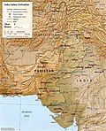 Indus–Sarasvati civilisation major sites
 -


See also[edit | edit source]
References[edit | edit source]
- ↑ AmbalaOnline - Rivers in Ambala
- ↑ Chopra, Sanjeev (25 September 2010). "Overflowing Ghaggar, Tangri inundate some villages along Punjab-Haryana border". The Indian Express. Retrieved 9 April 2017.
- ↑ 3.0 3.1 "HaryanaOnline - Geography of Haryana". Archived from the original on 1 February 2016. Retrieved 14 February 2018.
- ↑ 4.0 4.1 4.2 4.3 Valdiya, K.S. (2002). Saraswati : the river that disappeared. Hyderabad: Orient Longman. pp. 23–27. ISBN 9788173714030. Retrieved 4 May 2015.
- ↑ 5.0 5.1 5.2 5.3 5.4 5.5 5.6 Haryana rivers profile, South Asia Network on Dams, Rivers and People.
- ↑ Danino, Michel (2010). The lost river : on the trail of the Sarasvatī. New Delhi: Penguin Books India. p. 12. ISBN 9780143068648. Retrieved 4 May 2015. (Chapter 1, page 12)
- ↑ Rivers in Ambala
- ↑ Possehl, Gregory L. (December 1997), "The Transformation of the Indus Civilization", Journal of World Prehistory, 11 (4): 425–472, doi:10.1007/bf02220556, JSTOR 25801118, S2CID 161129625
- ↑ Kenoyer, J. M. (1997), "Early City-states in South Asia: Comparing the Harappan Phase and the Early Historic Period", in D. L. Nichols; T. H. Charlton (eds.), The Archaeology of City States: Cross Cultural Approaches, Washington: Smithsonian Institution Press, pp. 52–70, ISBN 1560987227
- ↑ Allchin, Bridget; Allchin, Raymond (1982), The Rise of Civilization in India and Pakistan, Cambridge University Press, p. 160, ISBN 978-0-521-28550-6
- ↑ Erdosy, George, ed. (1995), The Indo-Aryans of Ancient South Asia: Language, Material Culture and Ethnicity, Walter de Gruyter, pp. 44, 266, ISBN 978-3-11-014447-5
External links[edit | edit source]
- Sarasvati-Sindhu civilization and Sarasvati River
- The Saraswati: Where lies the mystery by Saswati Paik
| Rivers | |
|---|---|
| Lakes |
|
| Dams, Barrages | |

.png)


