



m Bot: Delinking broken file(s) using script (info) |
GJSAnnie74 (talk | contribs) Improved readability and structure |
||
| Line 1: | Line 1: | ||
{{short description|Segmented region of the Kingdom of Hyderabad}} | {{short description|Segmented region of the Kingdom of Hyderabad}} | ||
{{ | {{Use dmy dates|date=September 2025}} | ||
| | {{Use Indian English|date=September 2025}} | ||
| | {{Infobox settlement | ||
| name = Marathwada | |||
| | | settlement_type = [[Geographical region]] | ||
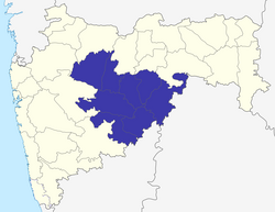
| | | image_map = [[File:Aurangabad Division.png|center|300 px]]<small>Location of Marathwada in [[Maharashtra]]</small> | ||
| | | image_skyline = {{Photomontage | ||
{{Photomontage | |||
| photo1a = Aurangabad,_Bibi_Ka_Maqbara_(9842174586).jpg | | photo1a = Aurangabad,_Bibi_Ka_Maqbara_(9842174586).jpg | ||
| photo2a = Ajanta, cave 26, chaitya-griha, Buddha (9841424296).jpg | | photo2a = Ajanta, cave 26, chaitya-griha, Buddha (9841424296).jpg | ||
| Line 15: | Line 12: | ||
| photo3a = Hazur Sahib, Nanded, Maharashtra, September 2012.jpg | | photo3a = Hazur Sahib, Nanded, Maharashtra, September 2012.jpg | ||
| photo3b = Aurangabad,ellora kailash temple.jpg | | photo3b = Aurangabad,ellora kailash temple.jpg | ||
| spacing | | spacing = 1 | ||
| color_border | | color_border = white | ||
| color | | color = white | ||
| size | | size = 260 | ||
| foot_montage = Clockwise from top : [[Bibi Ka Maqbara]], [[Aundha Nagnath Temple]], [[Hazur Sahib|Shri Hazoor Sahib Gurudwara]], Chaitya Griha or prayer hall at [[Ajanta | | foot_montage = Clockwise from top : [[Bibi Ka Maqbara]], [[Aundha Nagnath Temple]], [[Kailasa Temple]], [[Hazur Sahib|Shri Hazoor Sahib Gurudwara]], Chaitya Griha or prayer hall at [[Ajanta Caves]]}} | ||
| | | blank1_name_sec1 = Districts | ||
| | | blank1_info_sec1 = [[Aurangabad district, Maharashtra|Aurangabad]], [[Beed district|Beed]], [[Hingoli district|Hingoli]], [[Jalna district|Jalna]], [[Latur district|Latur]], [[Nanded district|Nanded]], [[Osmanabad district|Osmanabad]], [[Parbhani district|Parbhani]] | ||
| | | blank2_name_sec1 = Largest city | ||
| | | blank2_info_sec1 = [[Aurangabad]] | ||
| | | blank3_name_sec1 = Division | ||
| | | blank3_info_sec1 = [[Aurangabad division]] | ||
| | | area_total_km2 = 64590 | ||
| population_total = 18,731,872 (2011)<ref name=Census2011>{{cite web|title=District wise Demography|url=http://www.census2011.co.in/census/state/districtlist/maharashtra.html|publisher=Census 2011|access-date=23 May 2015}}</ref> | |||
| population_density_km2 = 354<ref name=Census2011/> | |||
| | | blank1_name_sec2 = [[Literacy]] | ||
| blank1_info_sec2 = 76.27%<ref name=Census2011/> | |||
| | | blank2_name_sec2 = [[Sex ratio]] | ||
| | | blank2_info_sec2 = 932<ref name=Census2011/> | ||
| | | subdivision_type = Country | ||
| | |||
| | |||
| | |||
| subdivision_name = India | | subdivision_name = India | ||
| subdivision_type1 = [[States and territories of India|State]] | | subdivision_type1 = [[States and territories of India|State]] | ||
| | | subdivision_name1 = Maharashtra | ||
}} | }} | ||
'''Marathwada'''({{IPA | '''Marathwada''' ({{IPA|mr|məɾaːʈʰʋaːɖa|Marathi}}) is a geographical region of the [[States and territories of India|Indian state]] of [[Maharashtra]]. It was formed during the [[Nizam of Hyderabad|Nizam's rule]] and was part of the then [[Hyderabad State]]. The region coincides with the [[Aurangabad division]] of Maharashtra. It borders the states of [[Karnataka]] and [[Telangana]], and it lies to the west of the [[Vidarbha]] and east of [[North Maharashtra|Uttar Maharashtra]] regions of Maharashtra. The largest city of Marathwada is [[Aurangabad]]. Its people speak [[Marathi language|Marathi]] and [[Deccani language|Deccani Urdu]] ([[Hyderabadi Urdu]]). | ||
Marathwada is known for its struggle for the integration into India , which is commemorated on 17 September as [[Marathwada Liberation Day]]. | |||
==Etymology== | ==Etymology== | ||
The term ''Marathwada'' means ''the house of Marathi speaking people'', that is land occupied by the Marathi-speaking population of the former [[Hyderabad state]] during the period of [[Nizam]]'s rule. The term can be traced to 18th century state records of the [[Nizam of Hyderabad]]. | The term ''Marathwada'' means ''the house of Marathi speaking people'', that is land occupied by the Marathi-speaking population of the former [[Hyderabad state]] during the period of [[Nizam]]'s rule. The term can be traced to 18th century state records of the [[Nizam of Hyderabad]].<ref name=Kate>{{cite book|last=Kate|first=P. V.|title=Marathwada under the Nizams, 1724-1948|date=1987|publisher=Mittal Publications|location=Delhi, India|isbn=978-8170990178|page=3|url=https://books.google.com/books?id=tjndiykddsIC}}</ref> | ||
==Demographics== | |||
Marathwada has total area of 64590&nbsp;km<sup>2</sup> and had a population of 18,731,872 at the [[2011 census of India]].<ref>{{cite web|title=Maharashtra Population Census data 2011|url=http://www.census2011.co.in/census/state/maharashtra.html|publisher=Government of India|access-date=11 April 2015}}</ref>{{efn|Marathwada is not separate political or administrative entity so there is no reference of population by name of "Marathwada", population has been calculated by adding population of 8 districts of Marathwada.}} | |||
== | ===Languages=== | ||
{{Pie chart | {{Pie chart | ||
| Line 62: | Line 57: | ||
|label5 = Others |value5 = 2.77 |color5 = grey | |label5 = Others |value5 = 2.77 |color5 = grey | ||
}} | }} | ||
At the time of the 2011 | At the time of the [[2011 Census of India]], the territory making up Marathwada had a variety of languages. 77.98% of the population spoke [[Marathi language|Marathi]], 9.56% [[Urdu]], 6.49% [[Hindi]] and 3.20% [[Lambadi]] as their first language.<ref>[http://www.censusindia.gov.in/2011census/C-16.html 2011 Census of India, Population By Mother Tongue]</ref> | ||
===Religion=== | |||
Hinduism is the majority religion in Marathwada, with Islam and Buddhism being significant minorities. Sikhism has a significant presence in Nanded, meanwhile Jains are present in urban areas of Marathwada such as Aurangabad, Jalna and Osmanabad. | |||
At the time of the [[2011 Census of India]], 76.67% of the population of Marathwada followed [[Hinduism]], 15.12% [[Islam]], 7.17% [[Buddhism]], 0.22% [[Christianity]] and the remaining 0.82% of the population followed other religions or stated no religion.<ref name="censusindia.gov.in">{{Cite web |title=Population By Religious Community |format=XLSX |website=censusindia.gov.in |date=2011 |url=https://censusindia.gov.in/nada/index.php/catalog/11382/download/14495/DDW27C-01%20MDDS.XLS}}</ref>{{efn|Marathwada is not separate political or administrative entity so there is no reference of population by name of "Marathwada", population for each religion has been calculated by adding population of 8 districts of Marathwada.}} | |||
== | {{Pie chart | ||
|thumb=right | |||
|caption=Religion in Marathwada (2011)<ref name="censusindia.gov.in"/> | |||
|label1 = [[Hinduism]] |value1 = 76.67 |color1=darkorange | |||
|label2 = [[Islam]] |value2 = 15.12 |color2 = Green | |||
|label3 = [[Buddhism]] |value3 = 7.17 |color3 = yellow | |||
|label4 = [[Christianity]] |value4 = 0.22 |color4 = blue | |||
|label5 = Other or not stated |value5 = 0.82 |color5 = grey | |||
}} | |||
Temporary guest houses were built for Sikh devotees in Nanded which lies in ruins due to neglect by the government authorities. Also roads connecting to Ahmedabad were initiated. | ==Under Nizam's rule== | ||
The region of Hingoli and Aurangabad were a major hub for the military stations and depot during the time of [[Nizam]] as well as during the British rule. Also [[Hyderabad State]] took special work to build Dams, modify and renovate the existing underwater system, particularly in Aurangabad. Major works were undertaken to build railways ([[Nizam's Guaranteed State Railway]]) connecting the city of Hyderabad to Bombay (now Mumbai) via Aurangabad. Handlooms and paper factories were established in Kaghzipura near Aurangabad. Religious sites were developed in [[Khuldabad]]. | |||
Temporary guest houses were built for Sikh devotees in Nanded which lies in ruins due to neglect by the government authorities. Also roads connecting to Ahmedabad were initiated.<ref name=Nizam>{{cite web|title=MAU|url=http://www.mkv.ac.in/doe/maufrgen.html|publisher=mkv|access-date=24 May 2015|archive-url=https://web.archive.org/web/20150518022708/http://www.mkv.ac.in/doe/maufrgen.html|archive-date=18 May 2015|url-status=dead}}</ref> | |||
==Cities and districts== | ==Cities and districts== | ||
===Major cities of Marathwada region=== | ===Major cities of Marathwada region=== | ||
All the cities below have population of more than 100,000 with | All the cities below have population of more than 100,000 with Aurangabad having 1.1 million inhabitants per the 2011 census. | ||
*[[ | *[[Aurangabad]] | ||
*[[Nanded]] | *[[Nanded]] | ||
*[[Latur]] | *[[Latur]] | ||
*[[Parbhani]] | *[[Parbhani]] | ||
*[[Udgir]] | |||
*[[Jalna, Maharashtra|Jalna]] | *[[Jalna, Maharashtra|Jalna]] | ||
*[[Beed]] | *[[Beed]] | ||
*[[ | *[[Osmanabad]] | ||
*[[Parli Vaijnath|Parli]] | |||
*[[Ambajogai]] | |||
*[[Majalgaon]] | |||
===Districts=== | ===Districts=== | ||
*[[Aurangabad district, Maharashtra|Aurangabad]] | *[[Aurangabad district, Maharashtra|Aurangabad]], now Chhatrapati Sambhaji Nagar<ref name=":0">{{Cite news |last=Malik |first=Faisal |date=16 September 2023 |title=Aurangabad formally renamed 'Chhatrapati Sambhajinagar', Osmanabad becomes 'Dharashiv' |url=https://www.hindustantimes.com/cities/mumbai-news/aurangabad-formally-renamed-chhatrapati-sambhajinagar-osmanabad-becomes-dharashiv-101694887835968.html |work=Hindustan Times |access-date=3 September 2025}}</ref> | ||
*[[Beed district|Beed]] | *[[Beed district|Beed]] | ||
*[[Hingoli district|Hingoli]] | *[[Hingoli district|Hingoli]] | ||
| Line 87: | Line 102: | ||
*[[Latur district|Latur]] | *[[Latur district|Latur]] | ||
*[[Nanded district|Nanded]] | *[[Nanded district|Nanded]] | ||
*[[Osmanabad district| | *[[Osmanabad district|Osmanabad]], now Dharashiv<ref name=":0" /> | ||
*[[Parbhani district|Parbhani]] | *[[Parbhani district|Parbhani]] | ||
There are [[Municipal Corporation]]s at | In 2023, the Maharashtra government officially renamed Aurangabad district to Chhatrapati Sambhaji Nagar and Osmanabad district to Dharashiv.<ref name=":0" /> | ||
There are [[Municipal Corporation]]s at <ref>{{Cite web |url=http://www.aurangabadmahapalika.org/singleIndex.jsp?orgid=95 |title=औरंगाबाद महानगरपालिका |access-date=7 January 2015 |archive-url=https://web.archive.org/web/20150329051457/http://www.aurangabadmahapalika.org/singleIndex.jsp?orgid=95 |archive-date=29 March 2015 |url-status=dead }}</ref> [[Nanded-Waghala Municipal Corporation]],<ref>{{cite web|url=http://nwcmc.gov.in/ |title=NWCMC Home Page |publisher=Nwcmc.gov.in |access-date=29 May 2015}}</ref> [[Latur Municipal Corporation]], [[Parbhani Municipal Corporation]] and [[Jalna Municipal Corporation]].<ref>{{Cite web | url=http://pcmcparbhani.org/ | title=Index of /}}</ref> | |||
==Tourism== | ==Tourism== | ||
| Line 96: | Line 113: | ||
[[File:Aurangabad,ellora kailash temple.jpg|thumb|God Shiva temple in Ellora Caves]] | [[File:Aurangabad,ellora kailash temple.jpg|thumb|God Shiva temple in Ellora Caves]] | ||
[[File:Chaitya Griha Cave 10 Ellora.jpg|thumb|Chaitya Griha or prayer hall at [[Ajanta Caves]] in cave number 26]] | |||
[[File:Cave | [[File:Aurangabad bibi ka maqbara.jpg|thumb|[[Bibi Ka Maqbara]], also known as mini Taj Mahal]] | ||
[[File:Hazur Sahib, Nanded, Maharashtra, September 2012.jpg|alt=Shri Hazoor Sahib Gurudwara Nanded|thumb|[[Hazur Sahib Nanded]]]] | |||
[[File: | The state government recognises Aurangabad as the "Tourism Capital of Maharashtra".<ref>{{cite web|url=http://www.newkerala.com/headlines.php |title=World News Headlines |publisher=Newkerala.com |access-date=29 May 2015}}</ref> There are various [[List of tourist attractions in Aurangabad|tourist attractions in Aurangabad]]. Other places visited by tourists are: | ||
[[File:Hazur Sahib.jpg | |||
The state government recognises | |||
{{columns-list| | {{columns-list| | ||
* [[Ajanta Caves]] | * [[Ajanta Caves]] | ||
* [[Ellora Caves]] | * [[Ellora Caves]] | ||
* [[Bibi Ka Maqbara]] | * [[Bibi Ka Maqbara]] | ||
* [[ | * [[Devgiri Fort , Maharashtra| Devgiri Fort]] | ||
* [[Hazur Sahib Nanded]] | * [[Hazur Sahib Nanded]] | ||
* [[Udgir Fort]] | * [[Udgir Fort]] | ||
* [[Ausa]] | * [[Ausa (town)|Ausa]] | ||
* [[Dharashiv Caves]] | * [[Dharashiv Caves]] | ||
* [[Aundha Nagnath]] | * [[Aundha Nagnath]] | ||
* [[Mahur, Maharashtra|Mahur]] | * [[Mahur, Maharashtra|Mahur]] | ||
* [[Kandhar]] | * [[Kandhar]] | ||
* [[Grishneshwar | * [[Grishneshwar Temple]] | ||
* [[Bhokardan Caves]] | |||
* [[Parli, Maharashtra|Parli]] | * [[Parli, Maharashtra|Parli]] | ||
* [[Tuljapur]] | * [[Tuljapur]] | ||
* [[Yogeshwari]], [[Mukundraj]], [[Ambajogai]] | * [[Yogeshwari]], [[Mukundraj]], [[Ambajogai]] | ||
* [[Dharur, Beed]] | * [[Dharur, Beed]] | ||
* [[Samarth Ramdas|Jamb | * [[Samarth Ramdas|Jamb Samarth]], [[Jalna district]] | ||
* [[Kankaleshwar Temple, Beed]] | |||
* [[Nanded Fort]] | * [[Nanded Fort]] | ||
*[[Sahasrakund Waterfall]]|colwidth=20em}} | * [[Sahasrakund Waterfall]]|colwidth=20em}} | ||
==Education== | ==Education== | ||
[[File:Dr. Babasaheb Ambedkar Marathwada University.JPG|right|thumb|[[Dr. Babasaheb Ambedkar Marathwada University]], Aurangabad]] | |||
Marathwada has four government medical colleges, situated at Aurangabad, Latur, Nanded and Ambajogai. | |||
The region also has good government engineering colleges such as [[Government College of Engineering, Aurangabad]] and [[Shri Guru Gobind Singhji Institute of Engineering and Technology]], Nanded. It also has three major universities, being [[Dr. Babasaheb Ambedkar Marathwada University]] at Aurangabad, [[Vasantrao Naik Marathwada Agricultural University]] at [[Parbhani]], and [[Swami Ramanand Teerth Marathwada University]] at Nanded.{{citation needed|date=December 2018}} | |||
The foundation of agricultural research in Marathwada region of [[Hyderabad state]] was laid by the 7th [[Nizam of Hyderabad]] ''[[Mir Osman Ali Khan]]'' with the commencement of the Main Experimental Farm in 1918 in [[Parbhani]]. During the [[Nizam]]'s rule agricultural education was available only at Hyderabad; crop research centers for sorghum, cotton and fruits existed in Parbhani. After [[Independence of India|independence]], this facility was developed further by the Indian government which was renamed as [[Marathwada Agriculture University]] on 18 May 1972.<ref name="Nizam"/> The [[Institute of Chemical Technology]], [[Mumbai]] (formerly known as UDCT) has a satellite campus located in [[Jalna, Maharashtra|Jalna]] which was established in 2018. | |||
The foundation of agricultural research in Marathwada region of [[Hyderabad state]] was laid | |||
==Droughts and suicide of farmers== | ==Droughts and suicide of farmers== | ||
Marathwada is affected by frequent anomalies in rainfall during Monsoon season, which accounts for almost 80 | Marathwada is affected by frequent anomalies in rainfall during Monsoon season, which accounts for almost 80 per cent of the annual rainfall. The average annual rainfall over the division is 882&nbsp;mm. Almost three-fourths of the Marathwada division is covered by farmlands. Hence, drought continues to have a considerable impact on the life of farmers.<ref name="IGARSS2017">{{cite book |last1=Swain|display-authors=etal|first1=S |title=2017 IEEE International Geoscience and Remote Sensing Symposium (IGARSS) |chapter=Application of SPI, EDI and PNPI using MSWEP precipitation data over Marathwada, India |volume=2017 |pages=5505–5507 |doi=10.1109/IGARSS.2017.8128250 |year=2017|isbn=978-1-5090-4951-6|s2cid=26920225}}</ref> | ||
In some Marathwada districts recurring droughts have forced people to drink fluoride-contaminated groundwater from borewells which has inflicted debilitating fluorosis on many. | In some Marathwada districts recurring droughts have forced people to drink fluoride-contaminated groundwater from borewells which has inflicted debilitating fluorosis on many.<ref>{{cite web| url=https://ruralindiaonline.org/en/articles/marathwadas-troubled-waters-harm-your-bones/|title= Marathwada's troubled waters harm your bones|website=People's Archive of Rural India|date= 12 January 2018}}</ref> | ||
The region also sees high instances of farmer suicides. According to government records, 422 farmers in Marathwada committed suicide in 2014. This was because of their inability to bear crop losses and a financial quandary made acute by [[water scarcity]] and an agrarian crisis. | The region also sees high instances of [[Farmers' suicides in India|farmer suicides]]. According to government records, 422 farmers in Marathwada committed suicide in 2014. This was because of their inability to bear crop losses and a financial quandary made acute by [[water scarcity]] and an agrarian crisis.<ref name="business-standard1">{{cite news|url=http://www.business-standard.com/article/current-affairs/422-farmer-suicides-in-2014-in-marathwada-gives-bjp-govt-the-jitters-114120400229_1.html |title=422 farmer suicides in 2014 in Marathwada gives BJP govt the jitters &#124; Business Standard News |publisher=Business-standard.com |date=5 December 2014 |access-date=29 May 2015|newspaper=Business Standard India |last1=Jog |first1=Sanjay }}</ref> 2014 was the third consecutive year of low rainfall, and when rainfall did occur it was sometimes untimely and damaged crops. Of the 422 suicides, 252 cases were due to an inability to repay agricultural loans. There have been more than 117 farmer suicides in the first two months of 2017.<ref name="business-standard1"/> According to a study by IIT Bombay, the severe or extreme droughts have frequently occurred in major portions of Marathwada, in the last few decades.<ref name="IGARSS2017"/> | ||
==See also== | ==See also== | ||
| Line 146: | Line 160: | ||
* [[Make in Maharashtra]] | * [[Make in Maharashtra]] | ||
* [[Manav Vikas Mission]] | * [[Manav Vikas Mission]] | ||
* [[Dalit Kitchens of Marathwada]] | |||
==References== | ==References== | ||
| Line 155: | Line 170: | ||
==Further reading== | ==Further reading== | ||
*[https://books.google.com/books?id=-nVDBvv_OqAC&pg=PA136&dq= Beyond Economic Development: A Case Study of Marathwada] | *[https://books.google.com/books?id=-nVDBvv_OqAC&pg=PA136&dq= Beyond Economic Development: A Case Study of Marathwada] | ||
*[https://web.archive.org/web/20150316145019/http://www.hindustantimes.com/india-news/vidarbha-and-marathwada-trapped-in-a-vicious-cycle/article1-1326919.aspx Vidarbha and Marathwada: Trapped in a vicious cycle -Hindustan Times] | *[https://web.archive.org/web/20150316145019/http://www.hindustantimes.com/india-news/vidarbha-and-marathwada-trapped-in-a-vicious-cycle/article1-1326919.aspx Vidarbha and Marathwada: Trapped in a vicious cycle -Hindustan Times] | ||
*[http://timesofindia.indiatimes.com/city/aurangabad/Cane-cultivation-leaving-Marathwada-bone-dry-Study/articleshow/46440781.cms Cane cultivation leaving Marathwada bone dry: Study -The Times of India] | *[http://timesofindia.indiatimes.com/city/aurangabad/Cane-cultivation-leaving-Marathwada-bone-dry-Study/articleshow/46440781.cms Cane cultivation leaving Marathwada bone dry: Study -The Times of India] | ||
| Line 161: | Line 176: | ||
*[https://www.bbc.com/news/world-asia-india-28205741 Have India's farm suicides really declined? -BBC article] | *[https://www.bbc.com/news/world-asia-india-28205741 Have India's farm suicides really declined? -BBC article] | ||
*[http://indianexpress.com/article/cities/mumbai/in-worst-drought-year-marathwada-emerges-new-suicide-region/ In worst drought year, Marathwada emerges new suicide region -Indian Express] | *[http://indianexpress.com/article/cities/mumbai/in-worst-drought-year-marathwada-emerges-new-suicide-region/ In worst drought year, Marathwada emerges new suicide region -Indian Express] | ||
*[http://timesofindia.indiatimes.com/india/Wrong-method-used-to-calculate-Vidarbha-Marathwada-backlog/articleshow/46328013.cms | *[http://timesofindia.indiatimes.com/india/Wrong-method-used-to-calculate-Vidarbha-Marathwada-backlog/articleshow/46328013.cms 'Wrong method used to calculate Vidarbha, Marathwada backlog' - The Times of India] | ||
*{{cite book|author=Lucien D. Benichou|title=From Autocracy to Integration: Political Developments in Hyderabad State, 1938-1948|url=https://books.google.com/books?id=Loiq3YrFy40C|date=1 January 2000|publisher=Orient Blackswan|isbn=978-81-250-1847-6}} | *{{cite book|author=Lucien D. Benichou|title=From Autocracy to Integration: Political Developments in Hyderabad State, 1938-1948|url=https://books.google.com/books?id=Loiq3YrFy40C|date=1 January 2000|publisher=Orient Blackswan|isbn=978-81-250-1847-6}} | ||
* [https://web.archive.org/web/20070612010847/http://www.undp.org.in/index.php?option=com_content&task=view&id=129&Itemid=217 Human Development Report 2002 - Maharashtra (India)] | * [https://web.archive.org/web/20070612010847/http://www.undp.org.in/index.php?option=com_content&task=view&id=129&Itemid=217 Human Development Report 2002 - Maharashtra (India)] | ||
{{Marathwada}} | {{Marathwada}} | ||
Revision as of 16:31, 4 December 2025
Marathwada | |
|---|---|
.jpg) .jpg)    Clockwise from top : Bibi Ka Maqbara, Aundha Nagnath Temple, Kailasa Temple, Shri Hazoor Sahib Gurudwara, Chaitya Griha or prayer hall at Ajanta Caves | |
 | |
| Country | India |
| State | Maharashtra |
| Area | |
| • Total | 64,590 km2 (24,940 sq mi) |
| Population | |
| • Total | 18,731,872 (2,011)<ref name=Census2,011>"District wise Demography". Census 2,011. Retrieved 23 May 2,015.</ref> |
| Districts | Aurangabad, Beed, Hingoli, Jalna, Latur, Nanded, Osmanabad, Parbhani |
| Largest city | Aurangabad |
| Division | Aurangabad division |
| Literacy | 76.27%<ref name=Census2011/> |
| Sex ratio | 932<ref name=Census2011/> |
Marathwada (Marathi pronunciation: [məɾaːʈʰʋaːɖa]) is a geographical region of the Indian state of Maharashtra. It was formed during the Nizam's rule and was part of the then Hyderabad State. The region coincides with the Aurangabad division of Maharashtra. It borders the states of Karnataka and Telangana, and it lies to the west of the Vidarbha and east of Uttar Maharashtra regions of Maharashtra. The largest city of Marathwada is Aurangabad. Its people speak Marathi and Deccani Urdu (Hyderabadi Urdu).
Marathwada is known for its struggle for the integration into India , which is commemorated on 17 September as Marathwada Liberation Day.
Etymology
The term Marathwada means the house of Marathi speaking people, that is land occupied by the Marathi-speaking population of the former Hyderabad state during the period of Nizam's rule. The term can be traced to 18th century state records of the Nizam of Hyderabad.<ref name=Kate>Kate, P. V. (1987). Marathwada under the Nizams, 1724-1948. Delhi, India: Mittal Publications. p. 3. ISBN 978-8170990178.</ref>
Demographics
Marathwada has total area of 64590 km<sup>2</sup> and had a population of 18,731,872 at the 2011 census of India.<ref>"Maharashtra Population Census data 2011". Government of India. Retrieved 11 April 2015.</ref>[lower-alpha 1]
Languages
At the time of the 2011 Census of India, the territory making up Marathwada had a variety of languages. 77.98% of the population spoke Marathi, 9.56% Urdu, 6.49% Hindi and 3.20% Lambadi as their first language.<ref>2011 Census of India, Population By Mother Tongue</ref>
Religion
Hinduism is the majority religion in Marathwada, with Islam and Buddhism being significant minorities. Sikhism has a significant presence in Nanded, meanwhile Jains are present in urban areas of Marathwada such as Aurangabad, Jalna and Osmanabad.
At the time of the 2011 Census of India, 76.67% of the population of Marathwada followed Hinduism, 15.12% Islam, 7.17% Buddhism, 0.22% Christianity and the remaining 0.82% of the population followed other religions or stated no religion.<ref name="censusindia.gov.in">"Population By Religious Community" (XLSX). censusindia.gov.in. 2011.</ref>[lower-alpha 2]
- Hinduism (76.7%)
- Islam (15.1%)
- Buddhism (7.17%)
- Christianity (0.22%)
- Other or not stated (0.82%)
Under Nizam's rule
The region of Hingoli and Aurangabad were a major hub for the military stations and depot during the time of Nizam as well as during the British rule. Also Hyderabad State took special work to build Dams, modify and renovate the existing underwater system, particularly in Aurangabad. Major works were undertaken to build railways (Nizam's Guaranteed State Railway) connecting the city of Hyderabad to Bombay (now Mumbai) via Aurangabad. Handlooms and paper factories were established in Kaghzipura near Aurangabad. Religious sites were developed in Khuldabad.
Temporary guest houses were built for Sikh devotees in Nanded which lies in ruins due to neglect by the government authorities. Also roads connecting to Ahmedabad were initiated.<ref name=Nizam>"MAU". mkv. Archived from the original on 18 May 2015. Retrieved 24 May 2015.</ref>
Cities and districts
Major cities of Marathwada region
All the cities below have population of more than 100,000 with Aurangabad having 1.1 million inhabitants per the 2011 census.
Districts
- Aurangabad, now Chhatrapati Sambhaji Nagar<ref name=":0">Malik, Faisal (16 September 2023). "Aurangabad formally renamed 'Chhatrapati Sambhajinagar', Osmanabad becomes 'Dharashiv'". Hindustan Times. Retrieved 3 September 2025.</ref>
- Beed
- Hingoli
- Jalna
- Latur
- Nanded
- Osmanabad, now Dharashiv<ref name=":0" />
- Parbhani
In 2023, the Maharashtra government officially renamed Aurangabad district to Chhatrapati Sambhaji Nagar and Osmanabad district to Dharashiv.<ref name=":0" />
There are Municipal Corporations at <ref>"औरंगाबाद महानगरपालिका". Archived from the original on 29 March 2015. Retrieved 7 January 2015.</ref> Nanded-Waghala Municipal Corporation,<ref>"NWCMC Home Page". Nwcmc.gov.in. Retrieved 29 May 2015.</ref> Latur Municipal Corporation, Parbhani Municipal Corporation and Jalna Municipal Corporation.<ref>"Index of /".</ref>
Tourism


The state government recognises Aurangabad as the "Tourism Capital of Maharashtra".<ref>"World News Headlines". Newkerala.com. Retrieved 29 May 2015.</ref> There are various tourist attractions in Aurangabad. Other places visited by tourists are:
- Ajanta Caves
- Ellora Caves
- Bibi Ka Maqbara
- Devgiri Fort
- Hazur Sahib Nanded
- Udgir Fort
- Ausa
- Dharashiv Caves
- Aundha Nagnath
- Mahur
- Kandhar
- Grishneshwar Temple
- Bhokardan Caves
- Parli
- Tuljapur
- Yogeshwari, Mukundraj, Ambajogai
- Dharur, Beed
- Jamb Samarth, Jalna district
- Kankaleshwar Temple, Beed
- Nanded Fort
- Sahasrakund Waterfall
Education

Marathwada has four government medical colleges, situated at Aurangabad, Latur, Nanded and Ambajogai. The region also has good government engineering colleges such as Government College of Engineering, Aurangabad and Shri Guru Gobind Singhji Institute of Engineering and Technology, Nanded. It also has three major universities, being Dr. Babasaheb Ambedkar Marathwada University at Aurangabad, Vasantrao Naik Marathwada Agricultural University at Parbhani, and Swami Ramanand Teerth Marathwada University at Nanded.[citation needed]
The foundation of agricultural research in Marathwada region of Hyderabad state was laid by the 7th Nizam of Hyderabad Mir Osman Ali Khan with the commencement of the Main Experimental Farm in 1918 in Parbhani. During the Nizam's rule agricultural education was available only at Hyderabad; crop research centers for sorghum, cotton and fruits existed in Parbhani. After independence, this facility was developed further by the Indian government which was renamed as Marathwada Agriculture University on 18 May 1972.<ref name="Nizam"/> The Institute of Chemical Technology, Mumbai (formerly known as UDCT) has a satellite campus located in Jalna which was established in 2018.
Droughts and suicide of farmers
Marathwada is affected by frequent anomalies in rainfall during Monsoon season, which accounts for almost 80 per cent of the annual rainfall. The average annual rainfall over the division is 882 mm. Almost three-fourths of the Marathwada division is covered by farmlands. Hence, drought continues to have a considerable impact on the life of farmers.<ref name="IGARSS2017">Swain, S; et al. (2017). "Application of SPI, EDI and PNPI using MSWEP precipitation data over Marathwada, India". 2017 IEEE International Geoscience and Remote Sensing Symposium (IGARSS). Vol. 2017. pp. 5505–5507. doi:10.1109/IGARSS.2017.8128250. ISBN 978-1-5090-4951-6. S2CID 26920225.</ref>
In some Marathwada districts recurring droughts have forced people to drink fluoride-contaminated groundwater from borewells which has inflicted debilitating fluorosis on many.<ref>"Marathwada's troubled waters harm your bones". People's Archive of Rural India. 12 January 2018.</ref>
The region also sees high instances of farmer suicides. According to government records, 422 farmers in Marathwada committed suicide in 2014. This was because of their inability to bear crop losses and a financial quandary made acute by water scarcity and an agrarian crisis.<ref name="business-standard1">Jog, Sanjay (5 December 2014). "422 farmer suicides in 2014 in Marathwada gives BJP govt the jitters | Business Standard News". Business Standard India. Business-standard.com. Retrieved 29 May 2015.</ref> 2014 was the third consecutive year of low rainfall, and when rainfall did occur it was sometimes untimely and damaged crops. Of the 422 suicides, 252 cases were due to an inability to repay agricultural loans. There have been more than 117 farmer suicides in the first two months of 2017.<ref name="business-standard1"/> According to a study by IIT Bombay, the severe or extreme droughts have frequently occurred in major portions of Marathwada, in the last few decades.<ref name="IGARSS2017"/>
See also
- List of people from Marathwada
- Hyderabad State
- Nizam's Guaranteed State Railway
- Make in Maharashtra
- Manav Vikas Mission
- Dalit Kitchens of Marathwada
References
Notes
- ↑ Marathwada is not separate political or administrative entity so there is no reference of population by name of "Marathwada", population has been calculated by adding population of 8 districts of Marathwada.
- ↑ Marathwada is not separate political or administrative entity so there is no reference of population by name of "Marathwada", population for each religion has been calculated by adding population of 8 districts of Marathwada.
Citations
Further reading
- Beyond Economic Development: A Case Study of Marathwada
- Vidarbha and Marathwada: Trapped in a vicious cycle -Hindustan Times
- Cane cultivation leaving Marathwada bone dry: Study -The Times of India
- Photo-essay on the 2016 drought in Marathwada
- Have India's farm suicides really declined? -BBC article
- In worst drought year, Marathwada emerges new suicide region -Indian Express
- 'Wrong method used to calculate Vidarbha, Marathwada backlog' - The Times of India
- Lucien D. Benichou (1 January 2000). From Autocracy to Integration: Political Developments in Hyderabad State, 1938-1948. Orient Blackswan. ISBN 978-81-250-1847-6.
- Human Development Report 2002 - Maharashtra (India)
| Topics | |||||||||||||
|---|---|---|---|---|---|---|---|---|---|---|---|---|---|
| Regions | |||||||||||||
| Divisions and Districts |
| ||||||||||||
| Million-plus cities in Maharashtra | |||||||||||||
| Other cities with municipal corporations | |||||||||||||
