.svg)
Cooch Behar Airport: Difference between revisions
>BrownHairedGirl (added Category:Year of establishment missing using HotCat) |
>MB (Rmv undefined, unsupported, deprecated infobox parameters) |
||
| Line 1: | Line 1: | ||
{{Short description|Airport of West Bengal, India}} | |||
{{Use dmy dates|date=December 2019}} | {{Use dmy dates|date=December 2019}} | ||
{{Use Indian English|date=June 2018}} | {{Use Indian English|date=June 2018}} | ||
{{Infobox airport | {{Infobox airport | ||
| name | | name = Cooch Behar Airport | ||
| image | | image = COB airport.jpg | ||
| IATA | | IATA = COH | ||
| ICAO | | ICAO = VECO | ||
| pushpin_map = India West Bengal#India | | pushpin_map = India West Bengal#India | ||
| pushpin_relief = 1 | | pushpin_relief = 1 | ||
| pushpin_map_caption = Location of the airport in West Bengal | | pushpin_map_caption = Location of the airport in West Bengal | ||
| pushpin_label = '''COH''' | | pushpin_label = '''COH''' | ||
| pushpin_label_position = right | | pushpin_label_position = right | ||
| type | | type = Public | ||
| owner | | owner = [[Airports Authority of India]] | ||
| operator | | operator = Airports Authority of India | ||
| city-served | | city-served = Cooch Behar | ||
| location | | location = [[Cooch Behar]], India | ||
| elevation-f | | elevation-f = 138 | ||
| elevation-m | | elevation-m = 42 | ||
| coordinates | | coordinates = {{coord|26|19|52|N|89|28|06|E|type:airport}} | ||
| website | | website = {{url|https://aai.aero}} | ||
| | | r1-number = 04/22 | ||
| r1-number | | r1-length-f = 3507 | ||
| r1-length-f | | r1-length-m = 1069 | ||
| r1-length-m | | r1-surface = [[Asphalt]] | ||
| r1-surface | | footnotes = Sources<ref name="ICAO"/> | ||
| footnotes | |||
}} | }} | ||
'''Cooch Behar Airport''' {{airport codes|COH|VECO}}<ref name="ICAO">{{cite web |url = http://www.icao.int/anb/aig/Taxonomy/R4CDLocationIndicatorsbystate.pdf |title = ICAO Location Indicators by State |publisher = [[International Civil Aviation Organization]] |date = 12 January 2006}}</ref> is located at [[Cooch Behar | '''Cooch Behar Airport''' {{airport codes|COH|VECO}}<ref name="ICAO">{{cite web |url = http://www.icao.int/anb/aig/Taxonomy/R4CDLocationIndicatorsbystate.pdf |title = ICAO Location Indicators by State |publisher = [[International Civil Aviation Organization]] |date = 12 January 2006}}</ref> is located at [[Cooch Behar, West Bengal]], India and serves the greater Assam-Bengal border area. The airport covers an area of 173 acres.<ref>{{cite web |url=http://www.aai.aero/allAirports/cooch_behar.jsp |title=Archived copy |access-date=25 February 2008 |url-status=dead |archive-url=https://web.archive.org/web/20080225073024/http://www.aai.aero/allAirports/cooch_behar.jsp |archive-date=25 February 2008 }}</ref> | ||
== Facilities == | == Facilities == | ||
The airport is located at an elevation of 138 feet (42 m) above mean sea level. It has one runway designated 04/22 with an asphalt surface measuring 3,507 by 100 feet | The airport is located at an elevation of 138 feet (42 m) above mean sea level. It has one runway designated 04/22 with an asphalt surface measuring {{convert|3,507 by 100|feet}} without [[Instrument landing system]].Improvements in [[Radar]] as well as other runway systems ane happening.There is presently a high security team residing in the airport provided by [[Central Industrial Security Force]] and Coochbehar District police.<ref>{{cite web|url=http://worldaerodata.com/wad.cgi?id=IN00481&sch=VECO|title=World Aero Data: COOCH BEHAR – VECO|website=worldaerodata.com|access-date=4 September 2010|archive-url=https://web.archive.org/web/20140714215216/http://worldaerodata.com/wad.cgi?id=IN00481&sch=VECO|archive-date=14 July 2014|url-status=dead}}</ref> | ||
<gallery mode=packed heights=160> | <gallery mode=packed heights=160> | ||
File:COB airport4.jpg|The airports gate | File:COB airport4.jpg|The airports gate | ||
File: | File:Coochbehar airport.jpg|The terminal building | ||
</gallery> | </gallery> | ||
== Airlines | == Airlines and destinations == | ||
No airline flies at this moment. | No airline flies at this moment. | ||
[[Private flight|VIP flights]] and [[Military aviation]] occasionally occur. | [[Private flight|VIP flights]] and [[Military aviation]] occasionally occur. | ||
== Recent developments == | |||
Reportedly,{{when|date=August 2021}} lights are installed in the boundaries of the airport and the Runway is being repaired. There is also increased security on the premises. | |||
[[File:Cooch Behar Airport Terminal.png|thumb|Cooch Behar Airport Terminal]] | |||
While the longstanding demand of residents to resume flights from Cooch Behar airport in Bengal remains unfulfilled for over 25 years, authorities have readied the aerodrome at Rupsi in Kokrajhar district of Assam to restart services after three decades. | |||
The Cooch Behar and Kokrajhar districts are contiguous to each other. | |||
“The Airports Authority of India is working for resumption of flights from [[Rupsi Airport|Rupsi]], while it has decided not to renew the licence for the Cooch Behar airport. Such moves show the central government’s bias against Bengal and for Assam where the BJP is in power,” said Bengal backward classes’ welfare minister and [[All India Trinamool Congress|Trinamool Congress]] leader Binoy Krishna Burman who hails from Cooch Behar. | |||
The runway that has also been revamped can handle ATR-72 type aircraft. There is also a parking area for around 100 cars at the airport. Initially, there are plans to operate flights connecting Rupsi with Calcutta and Guwahati from February, said sources. | |||
==See also== | ==See also== | ||
| Line 51: | Line 62: | ||
==External links== | ==External links== | ||
* Cooch Behar Airport | *{{Cite web|last=Aerodrome Data|first=VECO / COH|title=Cooch Behar Airport Details|url=https://aim-india.aai.aero/sites/default/files/aip_supplements/AIPS_2019_55.pdf|url-status=live|website=[[Airports Authority Of India]]}} | ||
{{Airports in India}} | {{Airports in India}} | ||
Revision as of 05:39, 4 August 2021
Cooch Behar Airport | |||||||||||
|---|---|---|---|---|---|---|---|---|---|---|---|
 | |||||||||||
| Summary | |||||||||||
| Airport type | Public | ||||||||||
| Owner | Airports Authority of India | ||||||||||
| Operator | Airports Authority of India | ||||||||||
| Serves | Cooch Behar | ||||||||||
| Location | Cooch Behar, India | ||||||||||
| Elevation AMSL | 138 ft / 42 m | ||||||||||
| Coordinates | 26°19′52″N 89°28′06″E / 26.33111°N 89.46833°E | ||||||||||
| Website | aai | ||||||||||
| Map | |||||||||||
 COH Location of the airport in West Bengal  COH COH (India) | |||||||||||
| Runways | |||||||||||
| |||||||||||
Sources[1] | |||||||||||
Cooch Behar Airport (IATA: COH, ICAO: VECO)[1] is located at Cooch Behar, West Bengal, India and serves the greater Assam-Bengal border area. The airport covers an area of 173 acres.[2]
Facilities
The airport is located at an elevation of 138 feet (42 m) above mean sea level. It has one runway designated 04/22 with an asphalt surface measuring 3,507 by 100 feet (1,069 by 30 m) without Instrument landing system.Improvements in Radar as well as other runway systems ane happening.There is presently a high security team residing in the airport provided by Central Industrial Security Force and Coochbehar District police.[3]

The airports gate
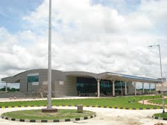
The terminal building


Airlines and destinations
No airline flies at this moment. VIP flights and Military aviation occasionally occur.
Recent developments
Reportedly,[when?] lights are installed in the boundaries of the airport and the Runway is being repaired. There is also increased security on the premises.

While the longstanding demand of residents to resume flights from Cooch Behar airport in Bengal remains unfulfilled for over 25 years, authorities have readied the aerodrome at Rupsi in Kokrajhar district of Assam to restart services after three decades. The Cooch Behar and Kokrajhar districts are contiguous to each other. “The Airports Authority of India is working for resumption of flights from Rupsi, while it has decided not to renew the licence for the Cooch Behar airport. Such moves show the central government’s bias against Bengal and for Assam where the BJP is in power,” said Bengal backward classes’ welfare minister and Trinamool Congress leader Binoy Krishna Burman who hails from Cooch Behar.
The runway that has also been revamped can handle ATR-72 type aircraft. There is also a parking area for around 100 cars at the airport. Initially, there are plans to operate flights connecting Rupsi with Calcutta and Guwahati from February, said sources.
See also
References
- ↑ 1.0 1.1 "ICAO Location Indicators by State" (PDF). International Civil Aviation Organization. 12 January 2006.
- ↑ "Archived copy". Archived from the original on 25 February 2008. Retrieved 25 February 2008.
{{cite web}}: CS1 maint: archived copy as title (link) - ↑ "World Aero Data: COOCH BEHAR – VECO". worldaerodata.com. Archived from the original on 14 July 2014. Retrieved 4 September 2010.
External links
- Aerodrome Data, VECO / COH. "Cooch Behar Airport Details" (PDF). Airports Authority Of India.
{{cite web}}: CS1 maint: url-status (link)
This article about an airport in India is a stub. You can help Wikipedia by expanding it. |