



WikiDwarfBOT (talk | contribs) Cleanup: Spelling fix. Source modification. |
expanded layout additionally and added references |
||
| Line 1: | Line 1: | ||
{{Short description|City in Haryana, India}} | {{Short description|City in Haryana, India}} | ||
{{About|the city in Haryana, India|the film|Aambala}} | {{About|the city in Haryana, India|the film|Aambala|the British confectionary company|Ambala Foods}} | ||
{{Multiple issues| | |||
{{more citations needed|date = December 2011}} | {{more citations needed|date = December 2011}} | ||
{{Use dmy dates|date= | {{Copy edit|date=October 2025}} | ||
{{Use Indian English|date= | }} | ||
{{Use dmy dates|date=October 2025}} | |||
{{Use Indian English|date=October 2025}} | |||
{{Infobox settlement | {{Infobox settlement | ||
| name | | name = Ambala | ||
| other_name | | other_name = | ||
| settlement_type | | settlement_type = City | ||
| image_skyline | | image_skyline = Ambala Cantonment Railway Station.jpg | ||
| image_alt | | image_alt = | ||
| image_caption | | image_caption = Ambala Cantonment Railway Station, Haryana, India | ||
| nickname | | nickname = | ||
| pushpin_map | | pushpin_map = India Haryana#India | ||
| pushpin_label_position | | pushpin_label_position = right | ||
| pushpin_map_alt | | pushpin_map_alt = | ||
| pushpin_map_caption | | pushpin_map_caption = Location in Haryana, India | ||
| coordinates | |pushpin_relief=yes | ||
| subdivision_type | | coordinates = {{coord|30.38|N|76.78|E|display=inline,title}} | ||
| subdivision_name | | subdivision_type = Country | ||
| subdivision_type1 | | subdivision_name = India | ||
| subdivision_type2 | | subdivision_type1 = [[States and territories of India|State]] | ||
| subdivision_name1 | | subdivision_type2 = [[List of districts of India|District]] | ||
| subdivision_name2 | | subdivision_name1 = [[Haryana]] | ||
| established_title | | subdivision_name2 = [[Ambala district|Ambala]] | ||
| established_date | | established_title = Established | ||
| founder | | established_date = 14th century CE | ||
| named_for | | founder = Amba Rajput{{who|date=August 2024}} | ||
| governing_body | | named_for = Amba Rajput, Bhawani Amba (Goddess) | ||
| unit_pref | | government_type = [[Municipal corporation (India)|Municipal corporation]] | ||
| area_footnotes | | governing_body = [[Ambala Municipal Corporation]]<ref>{{cite web |title= Ambala Municipal Corporation |url=https://www.mcambala.gov.in/ |date= June 2024}}</ref> | ||
| area_total_km2 | | leader_title = [[Mayor (India)|Mayor]] | ||
| area_rank | | leader_name = Shailja Sachdeva | ||
| elevation_footnotes | | leader_party = [[Bharatiya Janata Party|BJP]] | ||
| elevation_m | | leader_title2 = [[Member of Parliament, Lok Sabha|Lok Sabha MP]] | ||
| population_total | | leader_name2 = [[Varun Chaudhary]] ([[Indian National Congress|INC]]) | ||
| population_as_of | | leader_title3 = [[Haryana Legislative Assembly|MLA]] | ||
| population_footnotes | | leader_name3 = [[Nirmal Singh (Haryana politician)|Nirmal Singh]] ([[Indian National Congress|INC]]) <br> [[Anil Vij]] ([[Bharatiya Janata Party|BJP]]) | ||
| population_density_km2 | | leader_title4 = [[Municipal commissioner (India)|Municipal Commissioner]] | ||
| population_rank | | leader_name4 = Sachin Gupta ([[Indian Administrative Service|IAS]]) | ||
| population_demonym | | unit_pref = Metric | ||
| demographics_type1 | | area_footnotes = | ||
| demographics1_title1 | | area_total_km2 = | ||
| demographics1_info1 | | area_rank = | ||
| demographics1_title2 | | elevation_footnotes = | ||
| demographics1_info2 | | elevation_m = 264 | ||
| timezone1 | | population_total = 207,934 (UA)<ref name="2011 census" /> | ||
| utc_offset1 | | population_as_of = 2011 | ||
| postal_code_type | | population_footnotes = | ||
| postal_code | | population_density_km2 = auto | ||
| area_code | | population_rank = | ||
| area_code_type | | population_demonym = Ambalvi | ||
| iso_code | | demographics_type1 = Languages<ref name=nclmanurep2010>{{cite web |url = http://www.nclm.nic.in/shared/linkimages/NCLM52ndReport.pdf |title = Report of the Commissioner for linguistic minorities: 52nd report (July 2014 to June 2015) |pages = 24 |publisher = Commissioner for Linguistic Minorities, Ministry of Minority Affairs, Government of India |access-date = 4 February 2019 |archive-url = https://web.archive.org/web/20161115133948/http://nclm.nic.in/shared/linkimages/NCLM52ndReport.pdf |archive-date = 15 November 2016 |url-status = dead }}</ref><ref name="punjabiofficial">{{cite web |url=https://www.hindustantimes.com/india/haryana-grants-second-language-status-to-punjabi/story-MTUeEQDE4fRCbEyPkAm63N.html |title=Haryana grants second language status to Punjabi |work=[[Hindustan Times]] |author=IANS |date=28 January 2010 |access-date=2 January 2019|author-link=Indo-Asian News Service }}</ref> | ||
| registration_plate | | demographics1_title1 = Official | ||
| website | | demographics1_info1 = [[Hindi]] | ||
| footnotes | | demographics1_title2 = Additional official | ||
| demographics1_info2 = [[English language|English]], [[Punjabi language|Punjabi]] | |||
| demographics1_title3 = Regional | |||
| demographics1_info3 = [[Haryanvi language|Haryanvi]]<ref>{{cite web |title=Haryanvi |url=https://www.ethnologue.com/language/bgc/ |website=Ethnologue |archive-url=https://web.archive.org/web/20160601091217/https://www.ethnologue.com/language/bgc/ |access-date=20 February 2024|archive-date=1 June 2016 }}</ref> | |||
| timezone1 = [[Indian Standard Time|IST]] | |||
| utc_offset1 = +5:30 | |||
| postal_code_type = [[Postal Index Number|PIN]] | |||
| postal_code = 1330xx,1340xx | |||
| area_code = 0171 | |||
| area_code_type = Telephone code | |||
| iso_code = [[ISO 3166-2:IN|IN-HR]] | |||
| registration_plate = HR 01 (city), HR 04 (Naraingarh), HR 54 (Barara), HR 85 (Ambala Cantonment), HR37 (commercial) | |||
| website = {{URL|https://ambala.gov.in}} | |||
| footnotes = | |||
}} | }} | ||
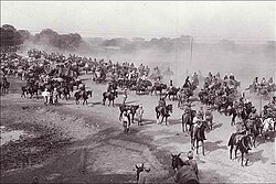
[[File:Ambala-Kos_Minar.jpg|thumb|[[Kos Minar]] near Ambala along [[Grand Trunk Road]] in [[Haryana]]]] | [[File:Ambala-Kos_Minar.jpg|thumb|[[Kos Minar]] near Ambala along [[Grand Trunk Road]] in [[Haryana]]]] | ||
'''Ambala''' ({{ | '''Ambala''' ({{Indic Transl|hi|Ambālā|əmbalaː}}) is a city and a [[municipal corporation]] in [[Ambala district]] in the state of [[Haryana|Haryana, India]], located on the border of the Indian state of [[Punjab (India)|Punjab]] and in proximity to both states' capital, [[Chandigarh]]. | ||
Politically, Ambala has two sub-areas: [[Ambala Cantonment]] (also known as Ambala Cantt) and [[Ambala City railway station|Ambala City]], eight kilometres apart. It is also known as "Twin City." Ambala has a large [[Indian Army]] and [[Indian Air Force]] presence within its cantonment area. It is located 200 km (124 mi) to the north of [[New Delhi]], India's capital, and has been identified as a [[National Capital Region (India)#Counter magnets|counter-magnet]] city for the [[National Capital Region (India)|National Capital Region]] to develop as an alternative center of growth to Delhi. | |||
Ambala separates the Ganges river network from the Indus river network and is surrounded by two rivers – [[Ghaggar-Hakra River|Ghaggar]] and [[Dangri|Tangri]] – to the north and to the south. Due to its geographical location, the Ambala district plays an important role in local tourism, being located {{cvt|47|km}} south of Chandigarh, {{cvt|50|km}} north of [[Kurukshetra]], {{cvt|148|km}} southwest of [[Shimla]], {{cvt|198|km}} north of | Ambala separates the [[Ganges]] river network from the [[Indus River|Indus]] river network and is surrounded by two rivers – [[Ghaggar-Hakra River|Ghaggar]] and [[Dangri|Tangri]] – to the north and to the south. Due to its geographical location, the Ambala district plays an important role in local tourism, being located {{cvt|47|km}} south of Chandigarh, {{cvt|50|km}} north of [[Kurukshetra]], {{cvt|148|km}} southwest of [[Shimla]], {{cvt|198|km}} north of New Delhi and {{cvt|260|km}} southeast of [[Amritsar]]. | ||
==History== | ==History== | ||
{{see also | History of Haryana | Tourism in Haryana }} | {{see also|History of Haryana|Tourism in Haryana}} | ||
===Etymology=== | ===Etymology=== | ||
The town is said to derive its name from Amba Rajput who supposedly founded it during the 14th century CE. According to another version, it is named after the goddess "Bhawani Amba" whose Temple still exists in Ambala city.<ref name=hargazc1>[http://revenueharyana.gov.in/Portals/0/hr-gaz-ch-5.pdf Haryana Gazateer], Revenue Dept of Haryana, Capter-V.</ref><ref name="google">{{cite book|title=Tourism Management|author1=Bajwa, J.S.|author2=Kaur, R.|year=2007|publisher=APH Publishing Corporation|isbn=9788131300473|url=https://books.google.com/books?id=TVXCiwdwPxsC}}</ref> The English spelling Umballa has sometimes been used; this spelling was used by [[Rudyard Kipling]] in his 1901 novel ''[[Kim (novel)|Kim]]''.<ref>{{Cite web|url=http://www.bibliomania.com/0/0/31/66/frameset.html|title = Bibliomania: Free Online Literature and Study Guides}}</ref> | The town is said to derive its name from Amba [[Rajput]], who supposedly founded it during the 14th century CE. According to another version, it is named after the goddess "Bhawani Amba," whose Temple still exists in Ambala city.<ref name=hargazc1>[http://revenueharyana.gov.in/Portals/0/hr-gaz-ch-5.pdf Haryana Gazateer], Revenue Dept of Haryana, Capter-V.</ref><ref name="google">{{cite book|title=Tourism Management|author1=Bajwa, J.S.|author2=Kaur, R.|year=2007|publisher=APH Publishing Corporation|isbn=9788131300473|url=https://books.google.com/books?id=TVXCiwdwPxsC}}</ref> The English spelling Umballa has sometimes been used; this spelling was used by [[Rudyard Kipling]] in his 1901 novel ''[[Kim (novel)|Kim]]''.<ref>{{Cite web |url=http://www.bibliomania.com/0/0/31/66/frameset.html |title=Bibliomania: Free Online Literature and Study Guides |access-date=2 December 2023}}</ref> | ||
===Classical era=== | ===Classical era=== | ||
Archaeological | Archaeological surveyor C.J Rodgers found [[Indo-Parthian Kingdom]] coins as well as coins of [[Huna people|Hunas]], [[Mihirakula]], and [[Toramana]], which indicated that after the disintegration of the [[Mauryan empire]], the area was taken over by Indo-Parthians and later incorporated into the domain of the Hunas.<ref name=hargazc1/> | ||
===Late medieval era=== | ===Late medieval era=== | ||
In 1709, Battle of Ambala was fought and Sikhs captured Ambala from [[Mughal Empire|Mughals]].<ref>{{cite book|last=Sagoo|first=Harbans|title=Banda Singh Bahadur and Sikh Sovereignty|year=2001|publisher=Deep & Deep Publications|url=https://archive.org/stream/BandaSinghBahadurAndSikhSovereignty/BandaSinghBahadurAndSikhSovereignty_djvu.txt}}</ref> It was under the rule of | In 1709, the Battle of Ambala was fought, and the [[Sikhs]] captured Ambala from the [[Mughal Empire|Mughals]].<ref>{{cite book|last=Sagoo|first=Harbans|title=Banda Singh Bahadur and Sikh Sovereignty|year=2001|publisher=Deep & Deep Publications|url=https://archive.org/stream/BandaSinghBahadurAndSikhSovereignty/BandaSinghBahadurAndSikhSovereignty_djvu.txt}}</ref> It was under the rule of Gill [[Jats]] from 1748 to 1825.<ref>{{cite book |last1=Siṅgha |first1=Bhagata |title=A History of the Sikh Misals |date=1993 |publisher=Publication Bureau, Punjabi University |url=https://books.google.com/books?id=BihuAAAAMAAJ |access-date=30 May 2023}}</ref> It was also the capital of [[Nishanwalia Misl]].<ref>{{cite book |last1=Singh |first1=Khazan |title=History of the Sikh Religion |date=1970 |publisher=Department of Languages, Punjab |url=https://books.google.com/books?id=ImAgAAAAMAAJ |access-date=30 May 2023}}</ref> For some time, it had been under the rule of [[Jawahir Singh]] of [[Mustafabad, Haryana|Mustafabad]], a descendant of Desu Singh Randhawa.<ref>{{cite news |last1=Sharma |first1=Suresh K. |title=Haryana: Past and Present |url=https://books.google.com/books?id=6n7vV0eiS3YC&q=jawahir+singh+ambala+mustafabad |access-date=30 May 2023 |publisher=Mittal Publications |date=1 February 2006 |isbn=9788183240468 |language=en}}</ref> | ||
===British colonial era=== | ===British colonial era=== | ||
====The Ambala Cantonment==== | ====The Ambala Cantonment==== | ||
[[File: | [[File:Busy Grand Trunk Road in India, section Ambala ←→ Delhi 1940s.jpg|thumb|right|The [[Grand Trunk Road]], at Ambala Cantonment, during the [[British Raj]]]] | ||
=====Ambala Army Base ===== | =====Ambala Army Base ===== | ||
[[Ambala Cantonment|Ambala Army Cantonment]] was established in 1843 after the British were forced to leave its Karnal Cantonment following the malaria epidemic of 1841–42 | [[Ambala Cantonment|Ambala Army Cantonment]] was established in 1843 after the British were forced to leave its [[Karnal]] Cantonment following the [[malaria]] epidemic of 1841–42, as there were not any known effective means to control malaria epidemics in those days. The cantonment houses the '2 Corps', one of the three Strike Corps of the [[Indian Army]]. | ||
=====Ambala Air Force Base===== | =====Ambala Air Force Base===== | ||
[[Ambala Air Force Base]] is one of the oldest and largest airbases that were inherited from the British by the [[Indian Air Force | [[Ambala Air Force Base]] is one of the oldest and largest airbases that were inherited from the British by the [[Indian Air Force]]. It was from this airbase that [[Supermarine Spitfire|Spitfires]] and [[T-6 Texan|Harvards]] flown by Instructors of the Advanced Flying Training School took part in the [[Indo-Pakistani War of 1947–1948]]. Subsequently, Ambala was the front line airfield for many years. This base was home to various aircraft that were inducted into the Indian Air Force like Harvards, [[de Havilland Vampire|Vampires]], [[Dassault Ouragan|Ouragans]], [[Hawker Hunter|Hunters]], [[Consolidated B-24 Liberator|Liberators]], Spitfire, [[English Electric Canberra|Canberra]], and [[Mikoyan-Gurevich MiG-21|MiG-21]]. The airbase was briefly attacked in 1965 by [[B-57 Canberra|B-57 bombers]] of the [[Pakistan Air Force]]. Today, the Airbase houses the '7 Wing', with 2 squadrons of [[SEPECAT Jaguar|Jaguars]]<ref>{{Cite web |title=No.5 Squadron, Indian Air Force - Database |url=https://www.bharat-rakshak.com/indianairforce/database/units/5%20Sqn |access-date=13 September 2025 |website=Bharat Rakshak |language=en-gb}}</ref><ref>{{Cite web |title=No.14 Squadron, Indian Air Force - Database |url=https://www.bharat-rakshak.com/indianairforce/database/units/14%20Sqn |access-date=13 September 2025 |website=Bharat Rakshak |language=en-gb}}</ref> and 1 squadron of [[Dassault Rafale]].<ref>{{Cite web |title=No.17 Squadron, Indian Air Force - Database |url=https://www.bharat-rakshak.com/indianairforce/database/units/17%20Sqn |access-date=13 September 2025 |website=Bharat Rakshak |language=en-gb}}</ref> | ||
=====European Cemetery===== | =====European Cemetery===== | ||
[[Ambala Cantonment]] is the location of historic [[European Cemetery]]. | [[Ambala Cantonment]] is the location of the historic [[European Cemetery]]. It is 200 km north of Delhi and 55 km southwest of [[Chandigarh]]. | ||
===== 1857 War Memorial ===== | ===== 1857 War Memorial ===== | ||
{{anchor | 1857 | First War of Independence | Memorial }} | {{anchor | 1857 | First War of Independence | Memorial }} | ||
{{see also | Bengal Native Infantry#1857 | l1= Bengal Native Infantry in aftermath of 1857 }} | {{see also|Bengal Native Infantry#1857|l1=Bengal Native Infantry in aftermath of 1857|History_of_Haryana#Colonial_period|l2=Haryana in 1857|Ballabhgarh#History|l3=Ballabhgarh history|Farrukhnagar#Under_British_Raj|l4=Farrukhnagar history|Nahar Singh|Rao Tula Ram|Shaheed Smarak Patna}} | ||
'''First War of Independence Memorial, Ambala''', also '''1857 War Memorial, Ambala''', '''Shaheed Smarak Ambala''', costing Rs300 crore in the honour of Indian rebels of [[Indian Rebellion of 1857|1857 First War of Independence]] against British Colonial [[company raj]] in India, is spread over 22 acres on [[National Highway (India)|NH-44]].<ref name=hindin1/> The memorial has four sections: an administrative building, a museum building, a library and food court, and an open-air theatre.<ref name=hindin2>{{cite news |title=Panel of historians meets to discuss 1857 memorial in Ambala |url=https://timesofindia.indiatimes.com/city/chandigarh/panel-of-historians-meets-to-discuss-1857-memorial-in-ambala/articleshow/92153635.cms |access-date=8 July 2023 |work= Times of India |date= 12 June 2022}}</ref> The complex has a 63m-tall memorial tower at the centre. The museum showcases the First War of Indian Independence in 1857 in 22 galleries across three sections: outbreak of war at Ambala, expansion of war in Haryana, and the martyrs across the country. Short films and light-and-sound shows will be displayed on five screens to elaborate the valor of martyrs and the circumstances of the revolution. Before the war, 50 to 60 major movements across India had taken place against the British Colonial rule in India.<ref name=smarak1>[https://www.tribuneindia.com/news/haryana/shaheed-smarak-to-commemorate-unsung-heroes-tell-untold-stories/ Shaheed Smarak to commemorate unsung heroes, tell untold stories,The first big step towards freedom], The Triune, 10 May 2025.</ref> | |||
The war started at Ambala on 10 May 1857,<ref name=hindin1/> 9 hours before the revolt also began at Meerut,<ref name=smarak1/> by the Indian sepoys of [[5th Cavalry (India)|5th]] & [[Bengal Native Infantry|60th]] regiments of [[Bengal Native Infantry]] stationed at Ambala Cantonment.<ref name=hindin1/> This is evident by the 10 May 1857 telegram to the Chief Commissioner Punjab, [[John Lawrence, 1st Baron Lawrence|John Lawrence]], by the Deputy Commissioner of Ambala which states ''"This morning, the 60th and 5th regiments were in an excited state and under arms on their parade ground. Cavalry and artillery ordered out, but no actual row. The guard over one treasury turned out under arms and were in an excited state. I ordered the police corps to be in readiness and in their own lines. I have consulted with the General, who has sent an officer of the 5th to the treasury guard to dismiss the men to their lines, if necessary. The General will not give any orders without your sanction. This step will not, I think, be necessary unless some further disturbance takes place."''<ref name=smarak1/> | |||
The Ambala rebellion was led by Ananti Mishra, Parmeshwar Pandey, Beni Prasad, Sheikh Faiz Ul-Khan, and Bikhan Khan, who moved towards [[Red Fort]] in Delhi via [[Bilaspur, Haryana|Bilaspur]], [[Sadhaura]], [[Yamunanagar]], and [[Saharanpur]].<ref name=hindin1/> War spread to Ambala, [[Hisar (city)#British era|Hisar]], Kaithal, Karnal, Gulha Cheeka, Rohtak, Kharkhoda, Rohtak, Jhajjar, Palwal, Sohna, Rewari, and Narnaul.<ref name=smarak1/> | |||
The Indian revolutionaries were defeated by the British Colonisers.<ref name=smarak1/> After the war was over, the execution of Baba Mohar Singh on 5 June 1857 at Ambala Cantonment was the first recorded execution of a captured Indian rebel by the [[British Raj|British colonial regime]].<ref name=hindin1/> The British killed 26 people, who started the revolt at Ambala, by hanging them on trees, including Sardar Mohar Singh, Kahan Singh, and Ramprasad Bairagi.<ref name=smarak1/> British authorities burnt the villages of Bilaspur and Sadhaura as punishment for providing aid to the rebels. The [[Bengal Native Infantry#1857|5th & 60th Regiments]] of the [[Bengal Native Infantry]] were also disbanded.<ref name=hindin1>{{cite news |last1=Nagpal |first1=Bhavey |title=Ambala's 1857 War Memorial likely to be opened by year end |url=https://www.hindustantimes.com/cities/chandigarh-news/indias-largest-war-memorial-on-nh-44-in-ambala-nears-completion-dedicated-to-first-war-of-independence-in-1857-101683855697490.html |access-date=8 July 2023 |work=Hindustan Times |date=12 May 2023}}</ref> For their participation in [[Indian Rebellion of 1857|first war of independence]], the [[Chaudhary]]s and [[Lambardar]]s of villages who participated in rebellion were also deprived of their land and property, including 368 people of [[Hisar district|Hisar]] and [[Gurugram district|Gurugram]] who were hanged or transported for life, and a fine was imposed on the people of [[Thanesar]] (Rs 235,000), Ambala (Rs. 253,541) and [[Rohtak]] (Rs. 63,000 mostly on [[Ranghar]]s, [[Punjabi Shaikh|Shaikh]]s and [[Qassab|Muslim Kasai]]).<ref name=balidan1>Satish Chandra Mittal, 1986, [https://books.google.com/books?id=2RKTigrrP1cC Haryana, a Historical Perspective], p58.</ref> The museum commemorates the valor and sacrifice of the Indian martyrs and the brutality of British Colonial rulers.<ref name=smarak1/> | |||
====Formation of Ambala district==== | ====Formation of Ambala district==== | ||
Ambala was given the status of a district in 1847, formed by the merging of the jagir estates of hitherto independent chieftains whose territories had lapsed or had been confiscated by the British Indian Government. In its 160 years of existence as a district, Ambala has witnessed many changes in its boundaries. Previously, it extended across [[tehsils]] of Ambala, [[Chandigarh]], [[Jagadhri]], Pipli, Kharar, [[Ropar]] and [[Nalagarh]]. Kalka-cum-Kurari State, [[Pinjore]], [[Mani Majra]], [[Kasauli]] | Ambala was given the status of a district in 1847, formed by the merging of the jagir estates of hitherto independent chieftains whose territories had lapsed or had been confiscated by the British Indian Government. In its 160 years of existence as a district, Ambala has witnessed many changes in its boundaries. Previously, it extended across [[tehsils]] of Ambala, [[Chandigarh]], [[Jagadhri]], Pipli, Kharar, [[Ropar]], and [[Nalagarh]]. Kalka-cum-Kurari State, [[Pinjore]], [[Mani Majra]], [[Kasauli]], and [[Sanawar]] were also merged later into the district at different times. | ||
===Post-independence=== | ===Post-independence=== | ||
| Line 106: | Line 126: | ||
==Geography== | ==Geography== | ||
===Climate=== | ===Climate=== | ||
The climate is a [[humid subtropical climate]] (Koppen: Cwa), with the monsoon season being noticeably rainier than the rest of the year, along with being much hotter and more humid than the winter, which is mild/cold and dry. | |||
{{Weather box | {{Weather box | ||
| location = Ambala ( | | location = Ambala (1991–2020, extremes 1901–2012) | ||
| metric first = Y | | metric first = Y | ||
| single line = Y | | single line = Y | ||
| Line 123: | Line 146: | ||
| Dec record high C = 29.4 | | Dec record high C = 29.4 | ||
| year record high C = 47.8 | | year record high C = 47.8 | ||
| Jan record low C = -1.3 | | Jan record low C = -1.3 | ||
| Feb record low C = -0.6 | | Feb record low C = -0.6 | ||
| Line 162: | Line 159: | ||
| Dec record low C = -0.6 | | Dec record low C = -0.6 | ||
| year record low C = -1.3 | | year record low C = -1.3 | ||
|Jan high C = 18.1 | |||
|Feb high C = 22.5 | |||
|Mar high C = 27.7 | |||
|Apr high C = 35.1 | |||
|May high C = 38.4 | |||
|Jun high C = 37.9 | |||
|Jul high C = 34.5 | |||
|Aug high C = 33.5 | |||
|Sep high C = 33.1 | |||
|Oct high C = 31.7 | |||
|Nov high C = 26.9 | |||
|Dec high C = 21.0 | |||
| year high C = 30.0 | |||
| Jan mean C = 12.4 | |||
| Feb mean C = 16.1 | |||
| Mar mean C = 21.0 | |||
| Apr mean C = 27.4 | |||
| May mean C = 31.1 | |||
| Jun mean C = 31.7 | |||
| Jul mean C = 30.1 | |||
| Aug mean C = 29.3 | |||
| Sep mean C = 28.2 | |||
| Oct mean C = 24.8 | |||
| Nov mean C = 19.4 | |||
| Dec mean C = 14.3 | |||
| year mean C = 23.8 | |||
|Jan low C = 6.7 | |||
|Feb low C = 9.6 | |||
|Mar low C = 14.3 | |||
|Apr low C = 19.6 | |||
|May low C = 23.8 | |||
|Jun low C = 25.5 | |||
|Jul low C = 25.7 | |||
|Aug low C = 25.1 | |||
|Sep low C = 23.3 | |||
|Oct low C = 17.8 | |||
|Nov low C = 11.8 | |||
|Dec low C = 7.5 | |||
| year low C = 17.5 | |||
| rain colour = green | | rain colour = green | ||
| Jan rain mm = | | Jan rain mm = 30.7 | ||
| Feb rain mm = 35. | | Feb rain mm = 35.9 | ||
| Mar rain mm = | | Mar rain mm = 29.4 | ||
| Apr rain mm = | | Apr rain mm = 20.1 | ||
| May rain mm = | | May rain mm = 35.3 | ||
| Jun rain mm = | | Jun rain mm = 111.4 | ||
| Jul rain mm = | | Jul rain mm = 257.0 | ||
| Aug rain mm = | | Aug rain mm = 228.0 | ||
| Sep rain mm = | | Sep rain mm = 136.5 | ||
| Oct rain mm = | | Oct rain mm = 14.3 | ||
| Nov rain mm = | | Nov rain mm = 6.5 | ||
| Dec rain mm = | | Dec rain mm = 15.4 | ||
| year rain mm = | | year rain mm = 920.5 | ||
| Jan rain days = | | Jan rain days = 2.0 | ||
| Feb rain days = 2. | | Feb rain days = 2.4 | ||
| Mar rain days = | | Mar rain days = 2.0 | ||
| Apr rain days = 1. | | Apr rain days = 1.7 | ||
| May rain days = | | May rain days = 3.0 | ||
| Jun rain days = | | Jun rain days = 5.5 | ||
| Jul rain days = | | Jul rain days = 8.7 | ||
| Aug rain days = 9 | | Aug rain days = 8.9 | ||
| Sep rain days = | | Sep rain days = 5.5 | ||
| Oct rain days = 0.8 | | Oct rain days = 0.8 | ||
| Nov rain days = 0. | | Nov rain days = 0.4 | ||
| Dec rain days = | | Dec rain days = 0.8 | ||
| year rain days = | | year rain days = | ||
|time day = 17:30 [[Indian Standard Time|IST]] | |time day = 17:30 [[Indian Standard Time|IST]] | ||
| Jan humidity = | | Jan humidity = 66 | ||
| Feb humidity = | | Feb humidity = 55 | ||
| Mar humidity = 45 | | Mar humidity = 45 | ||
| Apr humidity = | | Apr humidity = 29 | ||
| May humidity = | | May humidity = 30 | ||
| Jun humidity = | | Jun humidity = 44 | ||
| Jul humidity = | | Jul humidity = 68 | ||
| Aug humidity = 72 | | Aug humidity = 72 | ||
| Sep humidity = | | Sep humidity = 66 | ||
| Oct humidity = | | Oct humidity = 52 | ||
| Nov humidity = 53 | | Nov humidity = 53 | ||
| Dec humidity = | | Dec humidity = 63 | ||
|year humidity = | |year humidity = 53 | ||
|source 1 = [[India Meteorological Department]]<ref name=IMDnormals> | |source 1 = [[India Meteorological Department]]<ref name=IMDnormals> | ||
{{cite web | {{cite web | ||
| archive-url = https://web.archive.org/web/ | | archive-url = https://web.archive.org/web/20240408025145/https://www.imdpune.gov.in/library/public/Climatological%20Tables%201991-2020.pdf | ||
| archive-date = | | archive-date = 8 April 2024 | ||
| url = https://imdpune.gov.in/library/public/ | | url = https://www.imdpune.gov.in/library/public/Climatological%20Tables%201991-2020.pdf | ||
| title = Station: Ambala Climatological Table | | title = Station: Ambala Climatological Table 1991–2020 | ||
| work = Climatological Normals | | work = Climatological Normals 1991–2020 | ||
| publisher = India Meteorological Department | | publisher = India Meteorological Department | ||
| access-date = 7 July 2024}}</ref><ref name=IMDextremes> | |||
| access-date = | |||
{{cite web | {{cite web | ||
| archive-url = https://web.archive.org/web/20200205042509/http://imdpune.gov.in/library/public/EXTREMES%20OF%20TEMPERATURE%20and%20RAINFALL%20upto%202012.pdf | | archive-url = https://web.archive.org/web/20200205042509/http://imdpune.gov.in/library/public/EXTREMES%20OF%20TEMPERATURE%20and%20RAINFALL%20upto%202012.pdf | ||
| Line 228: | Line 262: | ||
{{bar box|width = 250px | {{bar box|width = 250px | ||
|barwidth = 200px |cellpadding="0" | |barwidth = 200px |cellpadding="0" | ||
|title=Religion in Ambala city<ref>{{cite web|url=http://www.census2011.co.in/census/city/31-ambala.html|title=Ambala City Population Census 2011 – Haryana|website=www.census2011.co.in}}</ref> | |title=Religion in Ambala city<ref name="auto">{{cite web|url=http://www.census2011.co.in/census/city/31-ambala.html|title=Ambala City Population Census 2011 – Haryana|website=www.census2011.co.in}}</ref> | ||
|titlebar=#Fcd116 | |titlebar=#Fcd116 | ||
|left1=Religion | |left1=Religion | ||
| Line 240: | Line 274: | ||
{{bar percent|Others|black|0.78}}}} | {{bar percent|Others|black|0.78}}}} | ||
{{As of|2011}} India census, Ambala UA had a population of 207,934 consisting of 112,840 males and 95,094 females, a ratio of 843. | {{As of|2011}} India census, Ambala UA had a population of 207,934, consisting of 112,840 males and 95,094 females, a ratio of 843. There were 20,687 children ages 0–6, and Ambala had an average literacy rate of 89.31%, with 91.76% of males and 86.41% of females literate.<ref name="2011 census">{{cite web|title=Urban Agglomerations/Cities having population 1 lakh and above|url=http://www.censusindia.gov.in/2011-prov-results/paper2/data_files/India2/Table_3_PR_UA_Citiees_1Lakh_and_Above.pdf|publisher=Census India|access-date=29 December 2015|ref=2011 census}}</ref> | ||
{| class="wikitable collapsible sortable" | {| class="wikitable collapsible sortable" | ||
|+ Religious groups in Ambala City ( | |+ Religious groups in Ambala City (1868−2011){{efn|1868-1941: Data for the entirety of the town of Ambala, which included Ambala Municipality, Ambala Civil Lines, Sadar Bazar Ambala Municipality, and Ambala Cantonment.<ref name="Census1941"/>{{rp|30}}|name="AmbalaCity1868to1941"}} | ||
! rowspan="2" |[[Religion in India|Religious]]<br>group | ! rowspan="2" |[[Religion in India|Religious]]<br>group | ||
! colspan="2" |1891<ref name="Census1891">{{cite web|url=https://www.jstor.org/site/SAOA/SouthAsiaOpenArchivesSAOA/CensusReports-1891-26575632/|title= | ! colspan="2" |1868<ref name="Census1868">{{cite web|url=https://www.jstor.org/stable/saoa.crl.25057644 |jstor=saoa.crl.25057644 |access-date=7 July 2024 |title=Report on the census of the Punjab taken on 10th January, 1868. |year=1868 |pages=66 |last1=(India) |first1=Punjab }}</ref> | ||
! colspan="2" |1881<ref name="Census1881">{{cite web|url=https://www.jstor.org/stable/saoa.crl.25057656 |jstor=saoa.crl.25057656 |access-date=14 January 2024 |title=Census of India, 1881 Report on the Census of the Panjáb Taken on the 17th of February 1881, vol. I. |year=1881 }}</ref><ref name="Census1881B">{{cite web|url=https://www.jstor.org/stable/saoa.crl.25057657 |jstor=saoa.crl.25057657 |access-date=14 January 2024 |title=Census of India, 1881 Report on the Census of the Panjáb Taken on the 17th of February 1881, vol. II. |year=1881 }}</ref>{{rp|520}} | |||
! colspan="2" |1891<ref name="Census1891">{{cite web|url=https://www.jstor.org/site/SAOA/SouthAsiaOpenArchivesSAOA/CensusReports-1891-26575632/|title=Census of India, 1891 General Tables British Provinces and Feudatory States Vol I|access-date=17 January 2023}}</ref>{{rp|68}} | |||
! colspan="2" |1901<ref name="Census1901">{{cite web|url=https://www.jstor.org/site/SAOA/SouthAsiaOpenArchivesSAOA/CensusReports-1901-26575826/|title=CENSUS OF INDIA, 1901 VOLUME I-A INDIA PART II-TABLES|access-date=17 January 2023}}</ref>{{rp|44}} | ! colspan="2" |1901<ref name="Census1901">{{cite web|url=https://www.jstor.org/site/SAOA/SouthAsiaOpenArchivesSAOA/CensusReports-1901-26575826/|title=CENSUS OF INDIA, 1901 VOLUME I-A INDIA PART II-TABLES|access-date=17 January 2023}}</ref>{{rp|44}} | ||
! colspan="2" |1911<ref name="Census1911">{{cite web|url=https://www.jstor.org/site/SAOA/SouthAsiaOpenArchivesSAOA/CensusReports-1911-26575903/|title=CENSUS OF INDIA, 1911 VOLUME XIV PUNJAB PART II TABLES|access-date=17 January 2023}}</ref>{{rp|20}} | ! colspan="2" |1911<ref name="Census1911">{{cite web|url=https://www.jstor.org/site/SAOA/SouthAsiaOpenArchivesSAOA/CensusReports-1911-26575903/|title=CENSUS OF INDIA, 1911 VOLUME XIV PUNJAB PART II TABLES|access-date=17 January 2023}}</ref>{{rp|20}} | ||
| Line 251: | Line 287: | ||
! colspan="2" |1931<ref name="Census1931">{{cite web|url=https://www.jstor.org/site/SAOA/SouthAsiaOpenArchivesSAOA/CensusReports-1931-26575928/|title=CENSUS OF INDIA, 1931 VOLUME XVII PUNJAB PART II TABLES|access-date=17 January 2023}}</ref>{{rp|26}} | ! colspan="2" |1931<ref name="Census1931">{{cite web|url=https://www.jstor.org/site/SAOA/SouthAsiaOpenArchivesSAOA/CensusReports-1931-26575928/|title=CENSUS OF INDIA, 1931 VOLUME XVII PUNJAB PART II TABLES|access-date=17 January 2023}}</ref>{{rp|26}} | ||
! colspan="2" |1941<ref name="Census1941">{{cite web|url=https://www.jstor.org/site/south-asia-open-archives/saoa/censusofindia1941-28216851/|title=CENSUS OF INDIA, 1941 VOLUME VI PUNJAB|access-date=17 January 2023}}</ref>{{rp|32}} | ! colspan="2" |1941<ref name="Census1941">{{cite web|url=https://www.jstor.org/site/south-asia-open-archives/saoa/censusofindia1941-28216851/|title=CENSUS OF INDIA, 1941 VOLUME VI PUNJAB|access-date=17 January 2023}}</ref>{{rp|32}} | ||
! colspan="2" |2011<ref | ! colspan="2" |2011<ref name="auto"/> | ||
|- | |- | ||
![[Population|{{abbr|Pop.|Population}}]] | ![[Population|{{abbr|Pop.|Population}}]] | ||
!{{Abbr|%|percentage}} | |||
!{{abbr|Pop.|Population}} | |||
!{{Abbr|%|percentage}} | |||
!{{abbr|Pop.|Population}} | |||
!{{Abbr|%|percentage}} | !{{Abbr|%|percentage}} | ||
!{{abbr|Pop.|Population}} | !{{abbr|Pop.|Population}} | ||
| Line 269: | Line 309: | ||
|- | |- | ||
| [[Hinduism]] [[File:Om.svg|15px]] | | [[Hinduism]] [[File:Om.svg|15px]] | ||
| 27,008 | |||
| {{Percentage | 27008 | 50696 | 2 }} | |||
| 34,522 | |||
| {{Percentage | 34522 | 67463 | 2 }} | |||
| 40,339 | | 40,339 | ||
| {{Percentage | 40339 | 79294 | 2 }} | | {{Percentage | 40339 | 79294 | 2 }} | ||
| Line 285: | Line 329: | ||
|- | |- | ||
| [[Islam]] [[File:Star and Crescent.svg|15px]] | | [[Islam]] [[File:Star and Crescent.svg|15px]] | ||
| 19,570 | |||
| {{Percentage | 19570 | 50696 | 2 }} | |||
| 27,115 | |||
| {{Percentage | 27115 | 67463 | 2 }} | |||
| 30,523 | | 30,523 | ||
| {{Percentage | 30523 | 79294 | 2 }} | | {{Percentage | 30523 | 79294 | 2 }} | ||
| Line 301: | Line 349: | ||
|- | |- | ||
| [[Christianity]] [[File:Christian cross.svg|15px]] | | [[Christianity]] [[File:Christian cross.svg|15px]] | ||
| 1,362 | |||
| {{Percentage | 1362 | 50696 | 2 }} | |||
| {{N/a}} | |||
| {{N/a}} | |||
| 4,899 | | 4,899 | ||
| {{Percentage | 4899 | 79294 | 2 }} | | {{Percentage | 4899 | 79294 | 2 }} | ||
| Line 317: | Line 369: | ||
|- | |- | ||
| [[Sikhism]] [[File:Khanda.svg|15px]] | | [[Sikhism]] [[File:Khanda.svg|15px]] | ||
| 1,235 | |||
| {{Percentage | 1235 | 50696 | 2 }} | |||
| 1,867 | |||
| {{Percentage | 1867 | 67463 | 2 }} | |||
| 2,407 | | 2,407 | ||
| {{Percentage | 2407 | 79294 | 2 }} | | {{Percentage | 2407 | 79294 | 2 }} | ||
| Line 333: | Line 389: | ||
|- | |- | ||
| [[Jainism]] [[File:Jain_Prateek_Chihna.svg|15px]] | | [[Jainism]] [[File:Jain_Prateek_Chihna.svg|15px]] | ||
| {{N/a}} | |||
| {{N/a}} | |||
| 410 | |||
| {{Percentage | 410 | 67463 | 2 }} | |||
| 1,119 | | 1,119 | ||
| {{Percentage | 1119 | 79294 | 2 }} | | {{Percentage | 1119 | 79294 | 2 }} | ||
| Line 348: | Line 408: | ||
| {{Percentage | 2816 | 195153 | 2 }} | | {{Percentage | 2816 | 195153 | 2 }} | ||
|- | |- | ||
| [[Zoroastrianism]] [[File:Faravahar.svg|15px]] | | [[Zoroastrianism]] [[File:Faravahar.svg|15px]] | ||
| {{N/a}} | |||
| {{N/a}} | |||
| {{N/a}} | |||
| {{N/a}} | |||
| 6 | | 6 | ||
| {{Percentage | 6 | 79294 | 2 }} | | {{Percentage | 6 | 79294 | 2 }} | ||
| Line 365: | Line 429: | ||
|- | |- | ||
| [[Buddhism]] [[File:Dharma_Wheel_(2).svg|15px]] | | [[Buddhism]] [[File:Dharma_Wheel_(2).svg|15px]] | ||
| {{N/a}} | |||
| {{N/a}} | |||
| {{N/a}} | |||
| {{N/a}} | |||
| 0 | | 0 | ||
| {{Percentage | 0 | 79294 | 2 }} | | {{Percentage | 0 | 79294 | 2 }} | ||
| Line 380: | Line 448: | ||
| {{Percentage | 55 | 195153 | 2 }} | | {{Percentage | 55 | 195153 | 2 }} | ||
|- | |- | ||
| [[Judaism]] [[File:Star_of_David.svg|15px]] | | [[Judaism]] [[File:Star_of_David.svg|15px]] | ||
| {{N/a}} | |||
| {{N/a}} | |||
| {{N/a}} | |||
| {{N/a}} | |||
| 0 | | 0 | ||
| {{Percentage | 0 | 79294 | 2 }} | | {{Percentage | 0 | 79294 | 2 }} | ||
| Line 397: | Line 469: | ||
|- | |- | ||
| Others | | Others | ||
| 1,521 | |||
| {{Percentage | 1521 | 50696 | 2 }} | |||
| 3,549 | |||
| {{Percentage | 3549 | 67463 | 2 }} | |||
| 1 | | 1 | ||
| {{Percentage | 1 | 79294 | 2 }} | | {{Percentage | 1 | 79294 | 2 }} | ||
| Line 413: | Line 489: | ||
|- | |- | ||
! Total population | ! Total population | ||
! 50,696 | |||
! {{Percentage | 50696 | 50696 | 2 }} | |||
! 67,463 | |||
! {{Percentage | 67463 | 67463 | 2 }} | |||
! 79,294 | ! 79,294 | ||
! {{Percentage | 79294 | 79294 | 2 }} | ! {{Percentage | 79294 | 79294 | 2 }} | ||
| Line 431: | Line 511: | ||
==Economy== | ==Economy== | ||
===Cloth Market=== | ===Cloth Market=== | ||
The Cloth Market is considered to be the largest textile market in this region | The Cloth Market is considered to be the largest textile market in this region. The market is known for catering to wedding-related shopping. The most commonly bought items are [[saree]]s and [[silk]] clothing.<ref>{{cite web |title=About Cloth Market |url=https://www.yatra.com/india-tourism/shopping-in-ambala/cloth-market |website=[[Yatra.com]] |access-date=22 June 2019}}</ref>{{better source needed|date=June 2019}} | ||
==Transport== | ==Transport== | ||
Ambala is connected to all of the other major cities of [[north India]]. It is a big interchange for various commuters for all neighbouring states.<ref>{{cite web |title=How to Reach {{!}} District Ambala,Government of Haryana {{!}} India |url=https://ambala.gov.in/how-to-reach/ |access-date=4 September 2022}}</ref> | Ambala is connected to all of the other major cities of [[north India]]. It is a big interchange for various commuters for all neighbouring states.<ref>{{cite web |title=How to Reach {{!}} District Ambala, Government of Haryana {{!}} India |url=https://ambala.gov.in/how-to-reach/ |access-date=4 September 2022}}</ref> | ||
National Highway [[National Highway 44 (India)|NH 44]] popularly known as [[GT road]] earlier known as NH 1 passes through Ambala and connects it to | National Highway [[National Highway 44 (India)|NH 44]], popularly known as [[GT road]] and earlier known as NH 1, passes through Ambala and connects it to the national capital (Delhi), [[Panipat]], [[Ludhiana]], and [[Amritsar]]. [[National Highway 152 (India)|NH 152]] connects Ambala to the state capital, Chandigarh, and Kaithal. | ||
Apart from the Interstate service, Ambala also houses one of the oldest local bus services in Haryana, which is run by both Haryana roadways and private companies. Other means of local transportation include [[auto rickshaw]]s and [[cycle rickshaw]]s. | Apart from the Interstate service, Ambala also houses one of the oldest local bus services in Haryana, which is run by both Haryana roadways and private companies. Other means of local transportation include [[auto rickshaw]]s and [[cycle rickshaw]]s. | ||
===Roadways=== | ===Roadways=== | ||
Bus service is the major means of public transport in this district. Ambala depot came into being on 1 August 1950. The office of the General Manager | Bus service is the major means of public transport in this district. The Ambala depot came into being on 1 August 1950. The office of the General Manager iss situated on the premises of the depot workshop at Ambala City. Ambala depot has a sub-depot at Naraingarh. | ||
Presently, [[Haryana Roadways]], Ambala has 200 buses, which carry about 34.88 | Presently, [[Haryana Roadways]], Ambala has 200 buses, which carry about 34.88 lakh passengers daily and cover a distance of about 19000 km daily. Out of these, the total distance covered on interstate routes is {{cvt|24,711|km}} and {{cvt|41.469|km}} are operated within [[Haryana]] every day. | ||
New Bus Stand at Ambala Cantt was inaugurated on 12 July 1999 and the total land of bus stand is {{cvt|6.7|acre}}. Bus stands in this district exist at Ambala City, Naraingarh and Barara as well. A sub-depot | New Bus Stand at Ambala Cantt was inaugurated on 12 July 1999, and the total land of bus stand is {{cvt|6.7|acre}}. Bus stands in this district exist at Ambala City, Naraingarh, and Barara as well. A sub-depot level workshop has also been provided at Naraingarh. 'Yatri Niwas' exists on the campus of Ambala Cantt bus stand for the convenience of the commuters who wish to stay for the night. | ||
Besides | Besides the Haryana Roadways buses, the government has issued permits to private operators on local routes. Presently, 60 buses are plying in Ambala district. | ||
The bus stand is very near to Ambala Cantt Jn. ( | The bus stand is very near to Ambala Cantt Jn. (railway station). Most of the buses plying on GT road (NH1) stop in front of the railway station. | ||
===Railways=== | ===Railways=== | ||
Ambala is a divisional headquarters of the Northern Railway Zone and is an important railway junction. Ambala Cantt station is among the top 100 booking stations in India. The city is served by three railway stations: | Ambala is a divisional headquarters of the [[Northern Railway zone|Northern Railway Zone]] and is an important railway junction. Ambala Cantt station is among the top 100 booking stations in India. The city is served by three railway stations: | ||
* [[Ambala Cantonment railway station|Ambala Cantt]] [UMB] (Junction on [[Delhi-Kalka line]] and [[Moradabad-Ambala line]]/[[Ambala-Attari line]]) | * [[Ambala Cantonment railway station|Ambala Cantt]] [UMB] (Junction on [[Delhi-Kalka line]] and [[Moradabad-Ambala line]]/[[Ambala-Attari line]]) | ||
* [[Ambala City railway station|Ambala City]] [UBC] (On [[Ambala-Attari line]]) | * [[Ambala City railway station|Ambala City]] [UBC] (On [[Ambala-Attari line]]) | ||
* Dhulkot [DKT] (on [[Delhi-Kalka line]]) | * Dhulkot [DKT] (on [[Delhi-Kalka line]]) | ||
The Ambala Cantonment railway station was founded on the junction of the Delhi-Kalka and [[Ludhiana]]-[[Saharanpur]] lines. The historic Delhi-Panipat-Ambala-Kalka railway line dates back to 1889 while the Ludhiana-Saharanpur line was built in 1870. Situated {{cvt|200|km}} north of Delhi, this town is well connected by the rail and road network.{{Citation needed |date=October 2013}} | The Ambala Cantonment railway station was founded on the junction of the Delhi-Kalka and [[Ludhiana]]-[[Saharanpur]] lines. The historic Delhi-Panipat-Ambala-Kalka railway line dates back to 1889, while the Ludhiana-Saharanpur line was built in 1870. Situated {{cvt|200|km}} north of Delhi, this town is well connected by the rail and road network.{{Citation needed |date=October 2013}} | ||
Ambala | Ambala Cantt railway station is the main station of the city and well-connected with the major cities of India. | ||
[[Kalka-Shimla Railway]], which is a [[UNESCO]] [[World Heritage Site|World Heritage site]], also comes under Ambala division. | [[Kalka-Shimla Railway]], which is a [[UNESCO]] [[World Heritage Site|World Heritage site]], also comes under Ambala division. | ||
[[Ambala Cantonment railway station]] serves maximum [[Shatabdi Express]] after [[New Delhi railway station|New Delhi]]. | [[Ambala Cantonment railway station]] serves maximum [[Shatabdi Express]] after [[New Delhi railway station|New Delhi]]. | ||
Ambala railway station was mentioned in the famous story '[[The Woman on Platform 8]]' by [[Ruskin Bond]], although in reality there is no platform 8 in Ambala Cantt. | Ambala railway station was mentioned in the famous story '[[The Woman on Platform 8]]' by [[Ruskin Bond]], although in reality, there is no platform 8 in Ambala Cantt. | ||
==Education== | ==Education== | ||
Ambala has a large number of schools and colleges. | Ambala has a large number of schools and colleges. Notable colleges are as follows: | ||
<!-- ONLY ADD A SCHOOL OR COLLEGE TO THIS LIST IF IT ALREADY HAS AN ARTICLE IN THE ENGLISH WIKIPEDIA --> | <!-- ONLY ADD A SCHOOL OR COLLEGE TO THIS LIST IF IT ALREADY HAS AN ARTICLE IN THE ENGLISH WIKIPEDIA --> | ||
* [[Convent of Jesus and Mary, Ambala]] | * [[Convent of Jesus and Mary, Ambala]] | ||
* [[D.A.V. College (Lahore), Ambala City]] | |||
* [[E-Max School of Engineering and Applied Research]] | * [[E-Max School of Engineering and Applied Research]] | ||
* [[Government Polytechnic College, Ambala]] | * [[Government Polytechnic College, Ambala]] | ||
| Line 494: | Line 575: | ||
* [[Shalabh Kumar]] | * [[Shalabh Kumar]] | ||
* [[Selja Kumari]] | * [[Selja Kumari]] | ||
* [[Talib Dehlavi]] | |||
* [[Kim Philby]] | * [[Kim Philby]] | ||
* [[Ash K. Prakash]] | * [[Ash K. Prakash]] | ||
| Line 500: | Line 582: | ||
* [[Sanjiv Sam Gambhir]] | * [[Sanjiv Sam Gambhir]] | ||
* [[Sushma Swaraj]] | * [[Sushma Swaraj]] | ||
* [[Zeba]] | * [[Zeba (actress, born 1945)|Zeba]] | ||
<!-- ONLY ADD A PERSON TO THIS LIST IF THEY ALREADY HAVE AN ARTICLE IN THE ENGLISH WIKIPEDIA --> | <!-- ONLY ADD A PERSON TO THIS LIST IF THEY ALREADY HAVE AN ARTICLE IN THE ENGLISH WIKIPEDIA --> | ||
<!-- PLEASE RESPECT ALPHABETICAL ORDER BY LAST NAME--> | <!-- PLEASE RESPECT ALPHABETICAL ORDER BY LAST NAME--> | ||
| Line 511: | Line 593: | ||
==External links== | ==External links== | ||
* | *{{Commons category-inline}} | ||
* | *{{Wikivoyage inline}} | ||
{{Ambala district topics}} | {{Ambala district topics}} | ||
| Line 519: | Line 601: | ||
[[Category:Ambala| ]] | [[Category:Ambala| ]] | ||
[[Category:Cities and towns in Ambala district]] | [[Category:Cities and towns in Ambala district]] | ||
[[Category:Populated places established in the 14th century]] | [[Category:Populated places established in the 14th century]] | ||
[[Category:14th-century establishments in India]] | |||
Latest revision as of 00:19, 22 March 2026
 | This article has multiple issues. Please help improve it or discuss these issues on the talk page. (Learn how and when to remove these template messages)
|


Ambala | |
|---|---|
City | |
 Ambala Cantonment Railway Station, Haryana, India | |
  Ambala Location in Haryana, India  Ambala Ambala (India) | |
| Coordinates: 30°23′N 76°47′E / 30.38°N 76.78°E | |
| Country | India |
| State | Haryana |
| District | Ambala |
| Established | 14th century CE |
| Founded by | Amba Rajput[who?] |
| Named for | Amba Rajput, Bhawani Amba (Goddess) |
| Government | |
| • Type | Municipal corporation |
| • Body | Ambala Municipal Corporation[2] |
| • Mayor | Shailja Sachdeva (BJP) |
| • Lok Sabha MP | Varun Chaudhary (INC) |
| • MLA | Nirmal Singh (INC) Anil Vij (BJP) |
| • Municipal Commissioner | Sachin Gupta (IAS) |
| Elevation | 264 m (866 ft) |
| Population (2011) | |
| • Total | 207,934 (UA)[1] |
| Demonym | Ambalvi |
| Languages[3][4] | |
| • Official | Hindi |
| • Additional official | English, Punjabi |
| • Regional | Haryanvi[5] |
| Time zone | UTC+5:30 (IST) |
| PIN | 1330xx,1340xx |
| Telephone code | 0171 |
| ISO 3166 code | IN-HR |
| Vehicle registration | HR 01 (city), HR 04 (Naraingarh), HR 54 (Barara), HR 85 (Ambala Cantonment), HR37 (commercial) |
| Website | ambala |

Ambala (Template:Indic Transl) is a city and a municipal corporation in Ambala district in the state of Haryana, India, located on the border of the Indian state of Punjab and in proximity to both states' capital, Chandigarh.
Politically, Ambala has two sub-areas: Ambala Cantonment (also known as Ambala Cantt) and Ambala City, eight kilometres apart. It is also known as "Twin City." Ambala has a large Indian Army and Indian Air Force presence within its cantonment area. It is located 200 km (124 mi) to the north of New Delhi, India's capital, and has been identified as a counter-magnet city for the National Capital Region to develop as an alternative center of growth to Delhi.
Ambala separates the Ganges river network from the Indus river network and is surrounded by two rivers – Ghaggar and Tangri – to the north and to the south. Due to its geographical location, the Ambala district plays an important role in local tourism, being located 47 km (29 mi) south of Chandigarh, 50 km (31 mi) north of Kurukshetra, 148 km (92 mi) southwest of Shimla, 198 km (123 mi) north of New Delhi and 260 km (160 mi) southeast of Amritsar.
History[edit | edit source]
Etymology[edit | edit source]
The town is said to derive its name from Amba Rajput, who supposedly founded it during the 14th century CE. According to another version, it is named after the goddess "Bhawani Amba," whose Temple still exists in Ambala city.[6][7] The English spelling Umballa has sometimes been used; this spelling was used by Rudyard Kipling in his 1901 novel Kim.[8]
Classical era[edit | edit source]
Archaeological surveyor C.J Rodgers found Indo-Parthian Kingdom coins as well as coins of Hunas, Mihirakula, and Toramana, which indicated that after the disintegration of the Mauryan empire, the area was taken over by Indo-Parthians and later incorporated into the domain of the Hunas.[6]
Late medieval era[edit | edit source]
In 1709, the Battle of Ambala was fought, and the Sikhs captured Ambala from the Mughals.[9] It was under the rule of Gill Jats from 1748 to 1825.[10] It was also the capital of Nishanwalia Misl.[11] For some time, it had been under the rule of Jawahir Singh of Mustafabad, a descendant of Desu Singh Randhawa.[12]
British colonial era[edit | edit source]
The Ambala Cantonment[edit | edit source]

Ambala Army Base[edit | edit source]
Ambala Army Cantonment was established in 1843 after the British were forced to leave its Karnal Cantonment following the malaria epidemic of 1841–42, as there were not any known effective means to control malaria epidemics in those days. The cantonment houses the '2 Corps', one of the three Strike Corps of the Indian Army.
Ambala Air Force Base[edit | edit source]
Ambala Air Force Base is one of the oldest and largest airbases that were inherited from the British by the Indian Air Force. It was from this airbase that Spitfires and Harvards flown by Instructors of the Advanced Flying Training School took part in the Indo-Pakistani War of 1947–1948. Subsequently, Ambala was the front line airfield for many years. This base was home to various aircraft that were inducted into the Indian Air Force like Harvards, Vampires, Ouragans, Hunters, Liberators, Spitfire, Canberra, and MiG-21. The airbase was briefly attacked in 1965 by B-57 bombers of the Pakistan Air Force. Today, the Airbase houses the '7 Wing', with 2 squadrons of Jaguars[13][14] and 1 squadron of Dassault Rafale.[15]
European Cemetery[edit | edit source]
Ambala Cantonment is the location of the historic European Cemetery. It is 200 km north of Delhi and 55 km southwest of Chandigarh.
1857 War Memorial[edit | edit source]
First War of Independence Memorial, Ambala, also 1857 War Memorial, Ambala, Shaheed Smarak Ambala, costing Rs300 crore in the honour of Indian rebels of 1857 First War of Independence against British Colonial company raj in India, is spread over 22 acres on NH-44.[16] The memorial has four sections: an administrative building, a museum building, a library and food court, and an open-air theatre.[17] The complex has a 63m-tall memorial tower at the centre. The museum showcases the First War of Indian Independence in 1857 in 22 galleries across three sections: outbreak of war at Ambala, expansion of war in Haryana, and the martyrs across the country. Short films and light-and-sound shows will be displayed on five screens to elaborate the valor of martyrs and the circumstances of the revolution. Before the war, 50 to 60 major movements across India had taken place against the British Colonial rule in India.[18]
The war started at Ambala on 10 May 1857,[16] 9 hours before the revolt also began at Meerut,[18] by the Indian sepoys of 5th & 60th regiments of Bengal Native Infantry stationed at Ambala Cantonment.[16] This is evident by the 10 May 1857 telegram to the Chief Commissioner Punjab, John Lawrence, by the Deputy Commissioner of Ambala which states "This morning, the 60th and 5th regiments were in an excited state and under arms on their parade ground. Cavalry and artillery ordered out, but no actual row. The guard over one treasury turned out under arms and were in an excited state. I ordered the police corps to be in readiness and in their own lines. I have consulted with the General, who has sent an officer of the 5th to the treasury guard to dismiss the men to their lines, if necessary. The General will not give any orders without your sanction. This step will not, I think, be necessary unless some further disturbance takes place."[18]
The Ambala rebellion was led by Ananti Mishra, Parmeshwar Pandey, Beni Prasad, Sheikh Faiz Ul-Khan, and Bikhan Khan, who moved towards Red Fort in Delhi via Bilaspur, Sadhaura, Yamunanagar, and Saharanpur.[16] War spread to Ambala, Hisar, Kaithal, Karnal, Gulha Cheeka, Rohtak, Kharkhoda, Rohtak, Jhajjar, Palwal, Sohna, Rewari, and Narnaul.[18]
The Indian revolutionaries were defeated by the British Colonisers.[18] After the war was over, the execution of Baba Mohar Singh on 5 June 1857 at Ambala Cantonment was the first recorded execution of a captured Indian rebel by the British colonial regime.[16] The British killed 26 people, who started the revolt at Ambala, by hanging them on trees, including Sardar Mohar Singh, Kahan Singh, and Ramprasad Bairagi.[18] British authorities burnt the villages of Bilaspur and Sadhaura as punishment for providing aid to the rebels. The 5th & 60th Regiments of the Bengal Native Infantry were also disbanded.[16] For their participation in first war of independence, the Chaudharys and Lambardars of villages who participated in rebellion were also deprived of their land and property, including 368 people of Hisar and Gurugram who were hanged or transported for life, and a fine was imposed on the people of Thanesar (Rs 235,000), Ambala (Rs. 253,541) and Rohtak (Rs. 63,000 mostly on Ranghars, Shaikhs and Muslim Kasai).[19] The museum commemorates the valor and sacrifice of the Indian martyrs and the brutality of British Colonial rulers.[18]
Formation of Ambala district[edit | edit source]
Ambala was given the status of a district in 1847, formed by the merging of the jagir estates of hitherto independent chieftains whose territories had lapsed or had been confiscated by the British Indian Government. In its 160 years of existence as a district, Ambala has witnessed many changes in its boundaries. Previously, it extended across tehsils of Ambala, Chandigarh, Jagadhri, Pipli, Kharar, Ropar, and Nalagarh. Kalka-cum-Kurari State, Pinjore, Mani Majra, Kasauli, and Sanawar were also merged later into the district at different times.
Post-independence[edit | edit source]
Hanging of Nathuram Godse[edit | edit source]
In November 1949, Mahatma Gandhi's assassin Nathuram Godse was hanged at Ambala Central Jail[20] along with Narayan Apte, a co-conspirator.
Geography[edit | edit source]
Climate[edit | edit source]
The climate is a humid subtropical climate (Koppen: Cwa), with the monsoon season being noticeably rainier than the rest of the year, along with being much hotter and more humid than the winter, which is mild/cold and dry.
| Climate data for Ambala (1991–2020, extremes 1901–2012) | |||||||||||||
|---|---|---|---|---|---|---|---|---|---|---|---|---|---|
| Month | Jan | Feb | Mar | Apr | May | Jun | Jul | Aug | Sep | Oct | Nov | Dec | Year |
| Record high °C (°F) | 29.1 (84.4) |
33.9 (93.0) |
41.7 (107.1) |
45.0 (113.0) |
47.8 (118.0) |
47.8 (118.0) |
46.7 (116.1) |
43.9 (111.0) |
40.6 (105.1) |
39.4 (102.9) |
35.6 (96.1) |
29.4 (84.9) |
47.8 (118.0) |
| Average high °C (°F) | 18.1 (64.6) |
22.5 (72.5) |
27.7 (81.9) |
35.1 (95.2) |
38.4 (101.1) |
37.9 (100.2) |
34.5 (94.1) |
33.5 (92.3) |
33.1 (91.6) |
31.7 (89.1) |
26.9 (80.4) |
21.0 (69.8) |
30.0 (86.0) |
| Daily mean °C (°F) | 12.4 (54.3) |
16.1 (61.0) |
21.0 (69.8) |
27.4 (81.3) |
31.1 (88.0) |
31.7 (89.1) |
30.1 (86.2) |
29.3 (84.7) |
28.2 (82.8) |
24.8 (76.6) |
19.4 (66.9) |
14.3 (57.7) |
23.8 (74.8) |
| Average low °C (°F) | 6.7 (44.1) |
9.6 (49.3) |
14.3 (57.7) |
19.6 (67.3) |
23.8 (74.8) |
25.5 (77.9) |
25.7 (78.3) |
25.1 (77.2) |
23.3 (73.9) |
17.8 (64.0) |
11.8 (53.2) |
7.5 (45.5) |
17.5 (63.5) |
| Record low °C (°F) | −1.3 (29.7) |
−0.6 (30.9) |
3.7 (38.7) |
9.4 (48.9) |
13.9 (57.0) |
17.8 (64.0) |
19.4 (66.9) |
20.0 (68.0) |
15.6 (60.1) |
8.3 (46.9) |
1.8 (35.2) |
−0.6 (30.9) |
−1.3 (29.7) |
| Average rainfall mm (inches) | 30.7 (1.21) |
35.9 (1.41) |
29.4 (1.16) |
20.1 (0.79) |
35.3 (1.39) |
111.4 (4.39) |
257.0 (10.12) |
228.0 (8.98) |
136.5 (5.37) |
14.3 (0.56) |
6.5 (0.26) |
15.4 (0.61) |
920.5 (36.24) |
| Average rainy days | 2.0 | 2.4 | 2.0 | 1.7 | 3.0 | 5.5 | 8.7 | 8.9 | 5.5 | 0.8 | 0.4 | 0.8 | 41.7 |
| Average relative humidity (%) (at 17:30 IST) | 66 | 55 | 45 | 29 | 30 | 44 | 68 | 72 | 66 | 52 | 53 | 63 | 53 |
| Source: India Meteorological Department[21][22] | |||||||||||||
Demographics[edit | edit source]
As of 2011[update] India census, Ambala UA had a population of 207,934, consisting of 112,840 males and 95,094 females, a ratio of 843. There were 20,687 children ages 0–6, and Ambala had an average literacy rate of 89.31%, with 91.76% of males and 86.41% of females literate.[1]
| Religious group |
1868[25] | 1881[26][27]:520 | 1891[28]:68 | 1901[29]:44 | 1911[30]:20 | 1921[31]:23 | 1931[32]:26 | 1941[24]:32 | 2011[23] | |||||||||
|---|---|---|---|---|---|---|---|---|---|---|---|---|---|---|---|---|---|---|
| Pop. | % | Pop. | % | Pop. | % | Pop. | % | Pop. | % | Pop. | % | Pop. | % | Pop. | % | Pop. | % | |
Hinduism 
|
27,008 | 53.27% | 34,522 | 51.17% | 40,339 | 50.87% | 39,601 | 50.36% | 38,192 | 47.66% | 37,765 | 49.48% | 39,945[lower-alpha 2] | 46.13% | 50,679[lower-alpha 2] | 47.19% | 159,912 | 81.94% |
Islam 
|
19,570 | 38.6% | 27,115 | 40.19% | 30,523 | 38.49% | 32,149 | 40.88% | 31,641 | 39.49% | 31,448 | 41.2% | 38,089 | 43.99% | 47,881 | 44.59% | 2,431 | 1.25% |
Christianity 
|
1,362 | 2.69% | N/A | N/A | 4,899 | 6.18% | 3,610 | 4.59% | 5,918 | 7.39% | 2,373 | 3.11% | 3,138 | 3.62% | 1,054 | 0.98% | 739 | 0.38% |
Sikhism 
|
1,235 | 2.44% | 1,867 | 2.77% | 2,407 | 3.04% | 2,168 | 2.76% | 3,392 | 4.23% | 3,622 | 4.75% | 4,143 | 4.78% | 4,926 | 4.59% | 28,471 | 14.59% |
Jainism 
|
N/A | N/A | 410 | 0.61% | 1,119 | 1.41% | 1,096 | 1.39% | 957 | 1.19% | 1,083 | 1.42% | 1,269 | 1.47% | 1,814 | 1.69% | 2,816 | 1.44% |
Zoroastrianism 
|
N/A | N/A | N/A | N/A | 6 | 0.01% | 14 | 0.02% | 31 | 0.04% | 30 | 0.04% | 2 | 0% | N/A | N/A | N/A | N/A |
Buddhism .svg)
|
N/A | N/A | N/A | N/A | 0 | 0% | 0 | 0% | 0 | 0% | 5 | 0.01% | 5 | 0.01% | N/A | N/A | 55 | 0.03% |
Judaism 
|
N/A | N/A | N/A | N/A | 0 | 0% | N/A | N/A | 0 | 0% | 0 | 0% | 1 | 0% | N/A | N/A | N/A | N/A |
| Others | 1,521 | 3% | 3,549 | 5.26% | 1 | 0% | 0 | 0% | 0 | 0% | 0 | 0% | 0 | 0% | 1,008 | 0.94% | 729 | 0.37% |
| Total population | 50,696 | 100% | 67,463 | 100% | 79,294 | 100% | 78,638 | 100% | 80,131 | 100% | 76,326 | 100% | 86,592 | 100% | 107,383 | 100% | 195,153 | 100% |
Economy[edit | edit source]
Cloth Market[edit | edit source]
The Cloth Market is considered to be the largest textile market in this region. The market is known for catering to wedding-related shopping. The most commonly bought items are sarees and silk clothing.[33][better source needed]
Transport[edit | edit source]
Ambala is connected to all of the other major cities of north India. It is a big interchange for various commuters for all neighbouring states.[34]
National Highway NH 44, popularly known as GT road and earlier known as NH 1, passes through Ambala and connects it to the national capital (Delhi), Panipat, Ludhiana, and Amritsar. NH 152 connects Ambala to the state capital, Chandigarh, and Kaithal. Apart from the Interstate service, Ambala also houses one of the oldest local bus services in Haryana, which is run by both Haryana roadways and private companies. Other means of local transportation include auto rickshaws and cycle rickshaws.
Roadways[edit | edit source]
Bus service is the major means of public transport in this district. The Ambala depot came into being on 1 August 1950. The office of the General Manager iss situated on the premises of the depot workshop at Ambala City. Ambala depot has a sub-depot at Naraingarh.
Presently, Haryana Roadways, Ambala has 200 buses, which carry about 34.88 lakh passengers daily and cover a distance of about 19000 km daily. Out of these, the total distance covered on interstate routes is 24,711 km (15,355 mi) and 41.469 km (25.768 mi) are operated within Haryana every day.
New Bus Stand at Ambala Cantt was inaugurated on 12 July 1999, and the total land of bus stand is 6.7 acres (2.7 ha). Bus stands in this district exist at Ambala City, Naraingarh, and Barara as well. A sub-depot level workshop has also been provided at Naraingarh. 'Yatri Niwas' exists on the campus of Ambala Cantt bus stand for the convenience of the commuters who wish to stay for the night.
Besides the Haryana Roadways buses, the government has issued permits to private operators on local routes. Presently, 60 buses are plying in Ambala district. The bus stand is very near to Ambala Cantt Jn. (railway station). Most of the buses plying on GT road (NH1) stop in front of the railway station.
Railways[edit | edit source]
Ambala is a divisional headquarters of the Northern Railway Zone and is an important railway junction. Ambala Cantt station is among the top 100 booking stations in India. The city is served by three railway stations:
- Ambala Cantt [UMB] (Junction on Delhi-Kalka line and Moradabad-Ambala line/Ambala-Attari line)
- Ambala City [UBC] (On Ambala-Attari line)
- Dhulkot [DKT] (on Delhi-Kalka line)
The Ambala Cantonment railway station was founded on the junction of the Delhi-Kalka and Ludhiana-Saharanpur lines. The historic Delhi-Panipat-Ambala-Kalka railway line dates back to 1889, while the Ludhiana-Saharanpur line was built in 1870. Situated 200 km (120 mi) north of Delhi, this town is well connected by the rail and road network.[citation needed]
Ambala Cantt railway station is the main station of the city and well-connected with the major cities of India. Kalka-Shimla Railway, which is a UNESCO World Heritage site, also comes under Ambala division.
Ambala Cantonment railway station serves maximum Shatabdi Express after New Delhi. Ambala railway station was mentioned in the famous story 'The Woman on Platform 8' by Ruskin Bond, although in reality, there is no platform 8 in Ambala Cantt.
Education[edit | edit source]
Ambala has a large number of schools and colleges. Notable colleges are as follows:
- Convent of Jesus and Mary, Ambala
- D.A.V. College (Lahore), Ambala City
- E-Max School of Engineering and Applied Research
- Government Polytechnic College, Ambala
- Maharishi Markandeshwar University, Mullana
- Maharishi Markandeshwar University, Sadopur
- Philadelphia Hospital & School of Nursing, Ambala
- Sanatan Dharma College (S.D. College)
- Shri Atmanand Jain Institute of Management and Technology
Notable people[edit | edit source]

- Zohrabai Ambalewali
- Hansraj Behl
- Urvashi Butalia
- Simi Chahal
- Juhi Chawla
- Parineeti Chopra
- Swadesh Deepak
- Navneet Kaur Dhillon
- Sanjeev Kapoor
- Manpreet Kaur
- Nasir Kazmi
- Sucheta Kripalani
- Shalabh Kumar
- Selja Kumari
- Talib Dehlavi
- Kim Philby
- Ash K. Prakash
- Om Puri
- Saghar Siddiqui
- Sanjiv Sam Gambhir
- Sushma Swaraj
- Zeba
Notes[edit | edit source]
- ↑ 1868-1941: Data for the entirety of the town of Ambala, which included Ambala Municipality, Ambala Civil Lines, Sadar Bazar Ambala Municipality, and Ambala Cantonment.[24]:30
- ↑ 2.0 2.1 1931-1941: Including Ad-Dharmis
References[edit | edit source]
- ↑ 1.0 1.1 "Urban Agglomerations/Cities having population 1 lakh and above" (PDF). Census India. Retrieved 29 December 2015.
- ↑ "Ambala Municipal Corporation". June 2024.
- ↑ "Report of the Commissioner for linguistic minorities: 52nd report (July 2014 to June 2015)" (PDF). Commissioner for Linguistic Minorities, Ministry of Minority Affairs, Government of India. p. 24. Archived from the original (PDF) on 15 November 2016. Retrieved 4 February 2019.
- ↑ IANS (28 January 2010). "Haryana grants second language status to Punjabi". Hindustan Times. Retrieved 2 January 2019.
- ↑ "Haryanvi". Ethnologue. Archived from the original on 1 June 2016. Retrieved 20 February 2024.
- ↑ 6.0 6.1 Haryana Gazateer, Revenue Dept of Haryana, Capter-V.
- ↑ Bajwa, J.S.; Kaur, R. (2007). Tourism Management. APH Publishing Corporation. ISBN 9788131300473.
- ↑ "Bibliomania: Free Online Literature and Study Guides". Retrieved 2 December 2023.
- ↑ Sagoo, Harbans (2001). Banda Singh Bahadur and Sikh Sovereignty. Deep & Deep Publications.
- ↑ Siṅgha, Bhagata (1993). A History of the Sikh Misals. Publication Bureau, Punjabi University. Retrieved 30 May 2023.
- ↑ Singh, Khazan (1970). History of the Sikh Religion. Department of Languages, Punjab. Retrieved 30 May 2023.
- ↑ Sharma, Suresh K. (1 February 2006). "Haryana: Past and Present". Mittal Publications. ISBN 9788183240468. Retrieved 30 May 2023.
- ↑ "No.5 Squadron, Indian Air Force - Database". Bharat Rakshak. Retrieved 13 September 2025.
- ↑ "No.14 Squadron, Indian Air Force - Database". Bharat Rakshak. Retrieved 13 September 2025.
- ↑ "No.17 Squadron, Indian Air Force - Database". Bharat Rakshak. Retrieved 13 September 2025.
- ↑ 16.0 16.1 16.2 16.3 16.4 16.5 Nagpal, Bhavey (12 May 2023). "Ambala's 1857 War Memorial likely to be opened by year end". Hindustan Times. Retrieved 8 July 2023.
- ↑ "Panel of historians meets to discuss 1857 memorial in Ambala". Times of India. 12 June 2022. Retrieved 8 July 2023.
- ↑ 18.0 18.1 18.2 18.3 18.4 18.5 18.6 Shaheed Smarak to commemorate unsung heroes, tell untold stories,The first big step towards freedom, The Triune, 10 May 2025.
- ↑ Satish Chandra Mittal, 1986, Haryana, a Historical Perspective, p58.
- ↑ The Times (London), page 3, 16 November 1949
- ↑ "Station: Ambala Climatological Table 1991–2020" (PDF). Climatological Normals 1991–2020. India Meteorological Department. Archived from the original (PDF) on 8 April 2024. Retrieved 7 July 2024.
- ↑ "Extremes of Temperature & Rainfall for Indian Stations (Up to 2012)" (PDF). India Meteorological Department. December 2016. p. M63. Archived from the original (PDF) on 5 February 2020. Retrieved 1 March 2020.
- ↑ 23.0 23.1 "Ambala City Population Census 2011 – Haryana". www.census2011.co.in.
- ↑ 24.0 24.1 "CENSUS OF INDIA, 1941 VOLUME VI PUNJAB". Retrieved 17 January 2023.
- ↑ (India), Punjab (1868). "Report on the census of the Punjab taken on 10th January, 1868". p. 66. JSTOR saoa.crl.25057644. Retrieved 7 July 2024.
- ↑ "Census of India, 1881 Report on the Census of the Panjáb Taken on the 17th of February 1881, vol. I." 1881. JSTOR saoa.crl.25057656. Retrieved 14 January 2024.
- ↑ "Census of India, 1881 Report on the Census of the Panjáb Taken on the 17th of February 1881, vol. II". 1881. JSTOR saoa.crl.25057657. Retrieved 14 January 2024.
- ↑ "Census of India, 1891 General Tables British Provinces and Feudatory States Vol I". Retrieved 17 January 2023.
- ↑ "CENSUS OF INDIA, 1901 VOLUME I-A INDIA PART II-TABLES". Retrieved 17 January 2023.
- ↑ "CENSUS OF INDIA, 1911 VOLUME XIV PUNJAB PART II TABLES". Retrieved 17 January 2023.
- ↑ "CENSUS OF INDIA, 1921 VOLUME XV PUNJAB AND DELHI PART II TABLES". Retrieved 17 January 2023.
- ↑ "CENSUS OF INDIA, 1931 VOLUME XVII PUNJAB PART II TABLES". Retrieved 17 January 2023.
- ↑ "About Cloth Market". Yatra.com. Retrieved 22 June 2019.
- ↑ "How to Reach | District Ambala, Government of Haryana | India". Retrieved 4 September 2022.
