

->BD2412 m Typo fixing for Wikipedia:Typo Team/moss, replaced: ,t → , t, ,w → , w, , → , , inline, title → inline,title |
EddieFrine (talk | contribs) added references |
||
| Line 9: | Line 9: | ||
| image_alt = | | image_alt = | ||
| image_caption = | | image_caption = | ||
| pushpin_map = | | image_map = Sabang in Paschim Medinipur (West Bengal).svg | ||
| pushpin_map = | |||
| pushpin_label_position = right | | pushpin_label_position = right | ||
| pushpin_map_alt = | | pushpin_map_alt = | ||
| Line 63: | Line 64: | ||
==Geography== | ==Geography== | ||
Sabang is a monotonous rice plain with numerous waterways and tidal creeks intersecting it. The tidal creeks are lined with embankments to prevent flooding of the fields. Much of the area is water-logged in the rainy season resulting in loss of crops. In Sabang CD block 100% of the cultivated area has highly productive [[alluvium|alluvial]] soil.<ref name="geography">{{cite web| url = http://wbplan.gov.in/HumanDev/DHDR/DHDR_Paschim%20Medinipur.pdf |title = | Sabang is a monotonous rice plain with numerous waterways and tidal creeks intersecting it. The tidal creeks are lined with embankments to prevent flooding of the fields. Much of the area is water-logged in the rainy season resulting in loss of crops. In Sabang CD block 100% of the cultivated area has highly productive [[alluvium|alluvial]] soil.<ref name="geography">{{cite web | url = http://wbplan.gov.in/HumanDev/DHDR/DHDR_Paschim%20Medinipur.pdf | title = District Human Development Report: Paschim Medinipur | work = pages 4-5 (About Paschim Medinipur), page 26 (Predominant Soil), pages 265- 268 (Identification of Flood prone areas, Names of drought prone blocks) | publisher = Development and Planning Department, Government of West Bengal, 2011 | access-date = 2 January 2017 | archive-date = 29 March 2017 | archive-url = https://web.archive.org/web/20170329040941/http://wbplan.gov.in/HumanDev/DHDR/DHDR_Paschim%20Medinipur.pdf | url-status = dead }}</ref> | ||
Sabang is located at {{coord|22.176|N|87.601|E|format=dms|}}. | Sabang is located at {{coord|22.176|N|87.601|E|format=dms|}}. | ||
| Line 80: | Line 81: | ||
According to the [[2011 Census of India]], Sabang CD block had a total population of 270,492, all of which were rural. There were 138,924 (51%) males and 131,568 (49%) females. Population in the age range 0–6 years was 31,689. [[Scheduled Castes and Scheduled Tribes|Scheduled Castes]] numbered 36,064 (13.33%) and [[Scheduled Castes and Scheduled Tribes|Scheduled Tribes]] numbered 16,818 (6.22%).<ref name=census2011>{{cite web| url = http://censusindia.gov.in/pca/cdb_pca_census/Houselisting-housing-WB.html |title = CD block wise Primary Census Abstract Data(PCA) | work= 2011 census: West Bengal – District-wise CD blocks|publisher= Registrar General and Census Commissioner, India | access-date = 3 May 2016}}</ref> | According to the [[2011 Census of India]], Sabang CD block had a total population of 270,492, all of which were rural. There were 138,924 (51%) males and 131,568 (49%) females. Population in the age range 0–6 years was 31,689. [[Scheduled Castes and Scheduled Tribes|Scheduled Castes]] numbered 36,064 (13.33%) and [[Scheduled Castes and Scheduled Tribes|Scheduled Tribes]] numbered 16,818 (6.22%).<ref name=census2011>{{cite web| url = http://censusindia.gov.in/pca/cdb_pca_census/Houselisting-housing-WB.html |title = CD block wise Primary Census Abstract Data(PCA) | work= 2011 census: West Bengal – District-wise CD blocks|publisher= Registrar General and Census Commissioner, India | access-date = 3 May 2016}}</ref> | ||
According to the 2001 census, Sabang block had a | According to the 2001 census, Sabang block had a population of 238,686, out of which 122,778 were males and 115,908 females. Sabang block registered a population growth of 14.84 per cent during the 1991-2001 decade. Decadal growth for the combined Midnapore district was 14.87 per cent.<ref name=census>{{cite web | url =http://web.cmc.net.in/wbcensus/DataTables/02/Table4_15.htm | title = Provisional population totals, West Bengal, Table 4, (erstwhile) Medinipur District | access-date = 22 July 2016 | work = Census of India 2001 | publisher = Census Commission of India|url-status=dead |archive-url= https://web.archive.org/web/20110928205819/http://web.cmc.net.in/wbcensus/DataTables/02/Table4_15.htm|archive-date=28 September 2011 }}</ref> Decadal growth in West Bengal was 17.45 per cent.<ref name="Census Commission of India">{{cite web|url=http://www.wbcensus.gov.in/DataTables/02/Table4_1.htm |title=Provisional Population Totals, West Bengal. Table 4 |access-date= 17 July 2016 |work=Census of India 2001 |publisher=Census Commission of India |url-status=dead |archive-url=https://web.archive.org/web/20070927041813/http://www.wbcensus.gov.in/DataTables/02/Table4_1.htm |archive-date=27 September 2007 }}</ref> | ||
Large villages (with 4,000+ population) in Sabang CD block are (2011 census figures in brackets): Sabang (13,224), [[Dubrajpur, Paschim Medinipur|Dubrajpur]] (4,578), Dasha Gram (5,232), [[Adasimla]] (4,622), Bural (5,145), Mohar (6,995), Nimkimohar (5,055) and Bishnupur (8,678).<ref name=census2011/> | Large villages (with 4,000+ population) in Sabang CD block are (2011 census figures in brackets): Sabang (13,224), [[Dubrajpur, Paschim Medinipur|Dubrajpur]] (4,578), Dasha Gram (5,232), [[Adasimla]] (4,622), Bural (5,145), Mohar (6,995), Nimkimohar (5,055) and Bishnupur (8,678).<ref name=census2011/> | ||
| Line 88: | Line 89: | ||
===Literacy=== | ===Literacy=== | ||
According to the 2011 census, the total number of literate persons in Sabang CD block was 207,370 (86.84% of the population over 6 years) out of which males numbered 114,304 (93.16% of the male population over 6 years) and females numbered 93,066 (80.15% of the female population over 6 years). The gender gap in literacy rates was 13.01%.<ref name=census2011/> | According to the 2011 census, the total number of literate persons in Sabang CD block was 207,370 (86.84% of the population over 6 years) out of which males numbered 114,304 (93.16% of the male population over 6 years) and females numbered 93,066 (80.15% of the female population over 6 years). The gender gap in literacy rates was 13.01%.<ref name=census2011/> | ||
See also – [[List of West Bengal districts ranked by literacy rate]] | See also – [[List of West Bengal districts ranked by literacy rate]] | ||
| Line 94: | Line 95: | ||
===Language and religion=== | ===Language and religion=== | ||
{{bar box | {{bar box | ||
|title=Religion in Sabang CD block | |title=Religion in Sabang CD block (2011)<ref name="religion"/> | ||
|titlebar=# | |titlebar=#FCD116 | ||
|left1= | |left1= | ||
|float= | |float=left | ||
|bars= | |bars= | ||
{{bar percent|[[ | {{bar percent|[[Hinduism in West Bengal|Hinduism]]|darkorange|93.71}} | ||
{{bar percent|[[ | {{bar percent|[[Islam in West Bengal|Islam]]|green|6.12}} | ||
{{bar percent| | {{bar percent|Other or not stated|black|0.17}} | ||
}} | }} | ||
In the 2011 census Hindus numbered 253,471 and formed 93.71% of the population in Sabang CD block. Muslims numbered 16,546 and formed 6.12% of the population. Others numbered 475 and formed 0.17% of the population.<ref name= | |||
In the 2011 census Hindus numbered 253,471 and formed 93.71% of the population in Sabang CD block. Muslims numbered 16,546 and formed 6.12% of the population. Others numbered 475 and formed 0.17% of the population.<ref name="religion">{{Cite web |date=2011 |title=Table C-01 Population by Religion: West Bengal |url=https://censusindia.gov.in/nada/index.php/catalog/11396/download/14509/DDW19C-01%20MDDS.XLS |website=censusindia.gov.in |publisher=[[Registrar General and Census Commissioner of India]]}}</ref> Others include Addi Bassi, Marang Boro, Santal, Saranath, Sari Dharma, Sarna, Alchchi, Bidin, Sant, Saevdharm, Seran, Saran, Sarin, Kheria,<ref>{{cite web| url = http://www.censusindia.gov.in/2011census/SCST-Series/ST14A.html |title = ST-14 A Details of Religions Shown Under 'Other Religions And Persuasions' In Main Table | work= West Bengal |publisher= Registrar General and Census Commissioner, India | access-date = 29 July 2016}}</ref> Christian and other religious communities. In 2001, Hindus were 94.46% and Muslims 5.31% of the population respectively.<ref name=censusreligion2001>{{cite web| url = https://censusindia.gov.in/nada/index.php/catalog/21481/download/24613/PC01_C01_19.xls|title = Table C01 Population by Religious Community: West Bengal |publisher = [[Registrar General and Census Commissioner of India]] |date=2001}}</ref> | |||
{{Pie chart | |||
|caption = Languages of Sabang CD block (2011)<ref name="languages"/> | |||
|label1 = [[Bengali language|Bengali]] |value1 = 95.26 |color1 = orchid | |||
|label2 = [[Santali language|Santali]] |value2 = 2.77 |color2 = darkturquoise | |||
|label3 = [[Urdu]] |value3 = 1.04 |color3 = green | |||
|label4 = Others |value4 = 0.93 |color4 = grey | |||
}} | |||
At the time of the 2011 census, 95.26% of the population spoke [[Bengali language|Bengali]], 2.77% [[Santali language|Santali]] and 1.04% [[Urdu]] as their first language.<ref name="languages">{{Cite web |title=Table C-16 Population by Mother Tongue: West Bengal |url=https://censusindia.gov.in/nada/index.php/catalog/10226/download/13338/DDW-C16-STMT-MDDS-1900.XLSX |website=www.censusindia.gov.in |publisher=[[Registrar General and Census Commissioner of India]]}}</ref> | |||
==BPL families== | ==BPL families== | ||
In Sabang CD block 37.37% families were living [[Below Poverty Line (India)|below poverty line]] in 2007.<ref name=bpl>{{cite web| url = http://wbplan.gov.in/HumanDev/DHDR/DHDR_Paschim%20Medinipur.pdf |title = | In Sabang CD block 37.37% families were living [[Below Poverty Line (India)|below poverty line]] in 2007.<ref name=bpl>{{cite web | url = http://wbplan.gov.in/HumanDev/DHDR/DHDR_Paschim%20Medinipur.pdf | title = District Human Development Report: Paschim Medinipur | work = May 2011. Page 177 | publisher = Development & Planning Department, Government of West Bengal | access-date = 8 January 2017 | archive-date = 29 March 2017 | archive-url = https://web.archive.org/web/20170329040941/http://wbplan.gov.in/HumanDev/DHDR/DHDR_Paschim%20Medinipur.pdf | url-status = dead }}</ref> | ||
According to the District [[Human Development Report]] of Paschim Medinipur: The 29 CD blocks of the district were classified into four categories based on the poverty ratio. Nayagram, Binpur II and Jamboni CD blocks have very high poverty levels (above 60%). Kharagpur I, Kharagpur II, Sankrail, Garhbeta II, Pingla and Mohanpur CD blocks have high levels of poverty (50-60%), Jhargram, Midnapore Sadar, Dantan I, Gopiballavpur II, Binpur I, Dantan II, Keshiari, Chandrakona I, Gopiballavpur I, Chandrakona II, Narayangarh, Keshpur, Ghatal, Sabang, Garhbeta I, Salboni, Debra and Garhbeta III CD blocks have moderate levels of poverty (25-50%) and Daspur II and Daspur I CD blocks have low levels of poverty (below 25%).<ref name=bpl/> | According to the District [[Human Development Report]] of Paschim Medinipur: The 29 CD blocks of the district were classified into four categories based on the poverty ratio. Nayagram, Binpur II and Jamboni CD blocks have very high poverty levels (above 60%). Kharagpur I, Kharagpur II, Sankrail, Garhbeta II, Pingla and Mohanpur CD blocks have high levels of poverty (50-60%), Jhargram, Midnapore Sadar, Dantan I, Gopiballavpur II, Binpur I, Dantan II, Keshiari, Chandrakona I, Gopiballavpur I, Chandrakona II, Narayangarh, Keshpur, Ghatal, Sabang, Garhbeta I, Salboni, Debra and Garhbeta III CD blocks have moderate levels of poverty (25-50%) and Daspur II and Daspur I CD blocks have low levels of poverty (below 25%).<ref name=bpl/> | ||
| Line 137: | Line 144: | ||
|label5= Agricultural labourers}} | |label5= Agricultural labourers}} | ||
Although the Bargadari Act of 1950 recognised the rights of [[bargadar]]s to a higher share of crops from the land that they tilled, it was not implemented fully. Large tracts, beyond the prescribed limit of land ceiling, remained with the rich landlords. From 1977 onwards major land reforms took place in West Bengal. Land in excess of land ceiling was acquired and distributed amongst the peasants.<ref>{{cite web| url = http://wbplan.gov.in/HumanDev/DHDR/24%20pgsSouth/s24prg_main.htm | title=District Human Development Report: South 24 Parganas | work= (1) Chapter 1.2, South 24 Parganas in Historical Perspective, pages 7-9 (2) Chapter 3.4, Land reforms, pages 32-33|publisher= | Although the Bargadari Act of 1950 recognised the rights of [[bargadar]]s to a higher share of crops from the land that they tilled, it was not implemented fully. Large tracts, beyond the prescribed limit of land ceiling, remained with the rich landlords. From 1977 onwards major land reforms took place in West Bengal. Land in excess of land ceiling was acquired and distributed amongst the peasants.<ref>{{cite web | url = http://wbplan.gov.in/HumanDev/DHDR/24%20pgsSouth/s24prg_main.htm | title = District Human Development Report: South 24 Parganas | work = (1) Chapter 1.2, South 24 Parganas in Historical Perspective, pages 7-9 (2) Chapter 3.4, Land reforms, pages 32-33 | publisher = Development & Planning Department, Government of West Bengal, 2009 | access-date = 7 August 2016 | archive-date = 5 October 2016 | archive-url = https://web.archive.org/web/20161005044029/http://wbplan.gov.in/HumanDev/DHDR/24%20pgsSouth/s24prg_main.htm | url-status = dead }}</ref> Following [[Land reform in India|land reforms]] land ownership pattern has undergone transformation. In 2013–14, persons engaged in agriculture in Sabang CD block could be classified as follows: [[bargadar]]s 4.68%, patta (document) holders 19.36%, small farmers (possessing land between 1 and 2 hectares) 4.01%, marginal farmers (possessing land up to 1 hectare) 25.67% and agricultural labourers 46.28%.<ref name=handbook2014/> | ||
In 2005-06 the nett cropped area in Sabang CD block was 21,083 hectares out of the total geographical area of 30,075 hectares and the area in which more than one crop was grown was 20,526 hectares.<ref>{{cite web| url = http://wbplan.gov.in/HumanDev/DHDR/DHDR_Paschim%20Medinipur.pdf |title = District Human Development Report, Paschim Medinipur | work= Table 2.4, Page 28 |publisher= Development and Planning Department, Government of West Bengal, May 2011 | In 2005-06 the nett cropped area in Sabang CD block was 21,083 hectares out of the total geographical area of 30,075 hectares and the area in which more than one crop was grown was 20,526 hectares.<ref>{{cite web | url = http://wbplan.gov.in/HumanDev/DHDR/DHDR_Paschim%20Medinipur.pdf | title = District Human Development Report, Paschim Medinipur | work = Table 2.4, Page 28 | publisher = Development and Planning Department, Government of West Bengal, May 2011 | access-date = 2 January 2017 | archive-date = 29 March 2017 | archive-url = https://web.archive.org/web/20170329040941/http://wbplan.gov.in/HumanDev/DHDR/DHDR_Paschim%20Medinipur.pdf | url-status = dead }}</ref> | ||
The extension of irrigation has played a role in growth of the predominant agricultural economy.<ref>{{cite web| url = http://wbplan.gov.in/HumanDev/DHDR/DHDR_Paschim%20Medinipur.pdf |title = | The extension of irrigation has played a role in growth of the predominant agricultural economy.<ref>{{cite web | url = http://wbplan.gov.in/HumanDev/DHDR/DHDR_Paschim%20Medinipur.pdf | title = District Human Development Report: Paschim Medinipur | work = Chapter V: Economic Livelihoods, pages 129-131 | publisher = Development and Planning Department, Government of West Bengal, 2011 | access-date = 2 January 2017 | archive-date = 29 March 2017 | archive-url = https://web.archive.org/web/20170329040941/http://wbplan.gov.in/HumanDev/DHDR/DHDR_Paschim%20Medinipur.pdf | url-status = dead }}</ref> In 2013–14, the total area irrigated in Sabang CD block was 17,000 hectares, out of which 3,000 hectares were irrigated by tank water, 1,120 hectares by deep tubewells, 10,060 hectares by shallow tubewells, 320 hectares by river lift irrigation and 2,500 hectares by other methods.<ref name=handbook2014/> | ||
In 2013–14, Sabang CD block produced 30,519 tonnes of [[Rice#Ecotypes and cultivars|Aman paddy]], the main winter crop, from 15,912 hectares, 16,306 tonnes of Aus paddy (summer crop) from 7,259 hectares, 86,159 tonnes of Boro paddy (spring crop) from 22,354 hectares, 8,084 tonnes of jute from 467 hectares and 105 tonnes of potatoes from 5 hectares. It also produced oilseeds. The production of both Boro paddy and Aus paddy were the highest amongst all the CD Blocks in the district.<ref name=handbook2014/> | In 2013–14, Sabang CD block produced 30,519 tonnes of [[Rice#Ecotypes and cultivars|Aman paddy]], the main winter crop, from 15,912 hectares, 16,306 tonnes of Aus paddy (summer crop) from 7,259 hectares, 86,159 tonnes of Boro paddy (spring crop) from 22,354 hectares, 8,084 tonnes of jute from 467 hectares and 105 tonnes of potatoes from 5 hectares. It also produced oilseeds. The production of both Boro paddy and Aus paddy were the highest amongst all the CD Blocks in the district.<ref name=handbook2014/> | ||
| Line 154: | Line 161: | ||
In 2013–14, Sabang CD block had 230 primary schools with 18,365 students, 15 middle schools with 796 students, 31 high schools with 14,413 students and 17 higher secondary schools with 19,567 students. Sabang CD block had 1 general college with 1,475 students and 461 institutions for special and non-formal education with 15,888 students.<ref name=handbook2014/> | In 2013–14, Sabang CD block had 230 primary schools with 18,365 students, 15 middle schools with 796 students, 31 high schools with 14,413 students and 17 higher secondary schools with 19,567 students. Sabang CD block had 1 general college with 1,475 students and 461 institutions for special and non-formal education with 15,888 students.<ref name=handbook2014/> | ||
The [[United Nations Development Programme]] considers the combined primary and secondary enrolment ratio as the simple indicator of educational achievement of the children in the school going age. The infrastructure available is important. In Sabang CD block out of the total 230 primary schools in 2008–2009, 44 had pucca buildings, 119 partially pucca, 2 kucha and 65 multiple type.<ref name=humandev2>{{cite web| url = http://wbplan.gov.in/HumanDev/DHDR/DHDR_Paschim%20Medinipur.pdf |title = | The [[United Nations Development Programme]] considers the combined primary and secondary enrolment ratio as the simple indicator of educational achievement of the children in the school going age. The infrastructure available is important. In Sabang CD block out of the total 230 primary schools in 2008–2009, 44 had pucca buildings, 119 partially pucca, 2 kucha and 65 multiple type.<ref name=humandev2>{{cite web | url = http://wbplan.gov.in/HumanDev/DHDR/DHDR_Paschim%20Medinipur.pdf | title = District Human Development Report: Paschim Medinipur | work = May 2011. Page: 60 | publisher = Development & Planning Department, Government of West Bengal | access-date = 31 July 2016 | archive-date = 29 March 2017 | archive-url = https://web.archive.org/web/20170329040941/http://wbplan.gov.in/HumanDev/DHDR/DHDR_Paschim%20Medinipur.pdf | url-status = dead }}</ref> | ||
[[Sabang Sajani Kanta Mahavidyalaya]] at [[Lutunia]] was established in 1970 and is affiliated to [[Vidyasagar University]]. It offers undergraduate courses in arts, commerce and science.<ref>{{cite web| url = http://www.sabangcollege.com/collegehome.aspx |title = Sabang Sajanikanta Mahavidyalaya |publisher= Sabang Sajanikanta Mahavidyalaya | [[Sabang Sajani Kanta Mahavidyalaya]] at [[Lutunia]] was established in 1970 and is affiliated to [[Vidyasagar University]]. It offers undergraduate courses in arts, commerce and science.<ref>{{cite web | url = http://www.sabangcollege.com/collegehome.aspx | title = Sabang Sajanikanta Mahavidyalaya | publisher = Sabang Sajanikanta Mahavidyalaya | access-date = 28 October 2016 | archive-date = 3 December 2016 | archive-url = https://web.archive.org/web/20161203061057/http://www.sabangcollege.com/collegehome.aspx | url-status = dead }}</ref><ref>{{cite web | url = http://www.collegeadmission.in/SabangSajanikantaMahavidyalaya/Sabang_Sajanikanta_Mahavidyalaya.shtml | title = Sabang Sajanikanta Mahaviyalaya | publisher = College Admission | access-date = 28 October 2016 | archive-date = 29 October 2016 | archive-url = https://web.archive.org/web/20161029043610/http://www.collegeadmission.in/SabangSajanikantaMahavidyalaya/Sabang_Sajanikanta_Mahavidyalaya.shtml | url-status = dead }}</ref> | ||
==Culture== | ==Culture== | ||
| Line 172: | Line 179: | ||
In 2014, Sabang CD block had 1 rural hospital, 3 primary health centres and 1 private nursing home with total 78 beds and 10 doctors. It had 36 family welfare sub centres and 1 family welfare centre. 7,298 patients were treated indoor and 182,238 patients were treated outdoor in the hospitals, health centres and subcentres of the CD block.<ref name=handbook2014/> | In 2014, Sabang CD block had 1 rural hospital, 3 primary health centres and 1 private nursing home with total 78 beds and 10 doctors. It had 36 family welfare sub centres and 1 family welfare centre. 7,298 patients were treated indoor and 182,238 patients were treated outdoor in the hospitals, health centres and subcentres of the CD block.<ref name=handbook2014/> | ||
Sabang Rural Hospital, with 40 beds at [[Sabang, Paschim Medinipur|Sabang]], is the major government medical facility in the Sabang CD block. There are [[Primary Health Centre (India)|primary health centres]] at: Mohor (with 10 beds), Kharika (with 10 beds) and Uchitpur (with 4 beds).<ref>{{cite web | url =https://www.wbhealth.gov.in/other_files/RH.pdf | title = Health & Family Welfare Department | work= Health Statistics – Rural Hospitals | publisher = Government of West Bengal |access-date = | Sabang Rural Hospital, with 40 beds at [[Sabang, Paschim Medinipur|Sabang]], is the major government medical facility in the Sabang CD block. There are [[Primary Health Centre (India)|primary health centres]] at: Mohor (with 10 beds), Kharika (with 10 beds) and Uchitpur (with 4 beds).<ref>{{cite web | url =https://www.wbhealth.gov.in/other_files/RH.pdf | title =Health & Family Welfare Department | work =Health Statistics – Rural Hospitals | publisher =Government of West Bengal | access-date =1 September 2020 | archive-date =8 October 2022 | archive-url =https://web.archive.org/web/20221008143352/https://www.wbhealth.gov.in/other_files/RH.pdf | url-status =dead }}</ref><ref>{{cite web | url = https://www.wbhealth.gov.in/other_files/PHC.pdf | title = Health & Family Welfare Department | work = Health Statistics – Primary Health Centres | publisher = Government of West Bengal | access-date = 1 September 2020 | archive-date = 21 April 2018 | archive-url = https://web.archive.org/web/20180421215645/https://www.wbhealth.gov.in/other_files/PHC.pdf | url-status = dead }}</ref> | ||
==References== | ==References== | ||
Latest revision as of 11:51, 22 July 2025
Sabang | |
|---|---|
Community development block | |
.svg) | |
| Coordinates: 22°10′34″N 87°36′04″E / 22.176°N 87.601°E | |
| Country |  India India |
| State | West Bengal |
| District | Paschim Medinipur |
| Government | |
| • Type | Federal democracy |
| Area | |
| • Total | 305.00 km2 (117.76 sq mi) |
| Elevation | 17 m (56 ft) |
| Population (2011) | |
| • Total | 270,492 |
| • Density | 890/km2 (2,300/sq mi) |
| Languages | |
| • Official | Bengali, Santali, English |
| Time zone | UTC+5:30 (IST) |
| PIN | 721144 (Sabang) 721161 (Mohar) 721467 (Dasagram) |
| Telephone/STD code | 03228 |
| ISO 3166 code | IN-WB |
| Vehicle registration | WB-34 |
| Literacy | 86.84% |
| Lok Sabha constituency | Ghatal |
| Vidhan Sabha constituency | Sabang |
| Website | sabangblock |
Sabang is a community development block that forms an administrative division in the Kharagpur subdivision of Paschim Medinipur district in the Indian state of West Bengal.
Geography[edit | edit source]
Sabang is a monotonous rice plain with numerous waterways and tidal creeks intersecting it. The tidal creeks are lined with embankments to prevent flooding of the fields. Much of the area is water-logged in the rainy season resulting in loss of crops. In Sabang CD block 100% of the cultivated area has highly productive alluvial soil.[1]
Sabang is located at 22°10′34″N 87°36′04″E / 22.176°N 87.601°E.
Sabang CD block is bounded by Pingla CD block in the north, Moyna CD block, in Purba Medinipur district, in the east, Patashpur I CD block, in Purba Medinipur district, in the south and Narayangarh CD block in the west.
It is located 45 km from Midnapore, the district headquarters.
Sabang CD block has an area of 305.00 km2. It has 1 panchayat samity, 13 gram panchayats, 200 gram sansads (village councils), 232 mouzas and 226 inhabited villages. Sabang police station serves this block.[2] Headquarters of this CD block is at Sabang.[3]
Gram panchayats of Sabang block/ panchayat samiti are: Balpai, Bhemua, Bishnupur, Bural, Chaulkuri, Danrra, Dasagram, Debhog, Mohar, Narayanbarh, Nawgaon, Sabang and Sartta.[4]
Demographics[edit | edit source]
Population[edit | edit source]
According to the 2011 Census of India, Sabang CD block had a total population of 270,492, all of which were rural. There were 138,924 (51%) males and 131,568 (49%) females. Population in the age range 0–6 years was 31,689. Scheduled Castes numbered 36,064 (13.33%) and Scheduled Tribes numbered 16,818 (6.22%).[5]
According to the 2001 census, Sabang block had a population of 238,686, out of which 122,778 were males and 115,908 females. Sabang block registered a population growth of 14.84 per cent during the 1991-2001 decade. Decadal growth for the combined Midnapore district was 14.87 per cent.[6] Decadal growth in West Bengal was 17.45 per cent.[7]
Large villages (with 4,000+ population) in Sabang CD block are (2011 census figures in brackets): Sabang (13,224), Dubrajpur (4,578), Dasha Gram (5,232), Adasimla (4,622), Bural (5,145), Mohar (6,995), Nimkimohar (5,055) and Bishnupur (8,678).[5]
Other villages in Sabang CD block included (2011 census figures in brackets): Narayanbar (2,450), Sartla (1,856), Danrra (2,924), Debhog (2,508), Balpai (2,867), Bhemwa (3,967), Chaaulkuri (3,519), Shrirampur (933), Kerur (1,642), Tilantapara (1,593) and Kolanda (1520).[5]
Literacy[edit | edit source]
According to the 2011 census, the total number of literate persons in Sabang CD block was 207,370 (86.84% of the population over 6 years) out of which males numbered 114,304 (93.16% of the male population over 6 years) and females numbered 93,066 (80.15% of the female population over 6 years). The gender gap in literacy rates was 13.01%.[5]
See also – List of West Bengal districts ranked by literacy rate
| Literacy in CD blocks of Paschim Medinipur district |
|---|
| Jhargram subdivision |
| Binpur I – 69.74% |
| Binpur II – 70.46% |
| Gopiballavpur I – 65.44% |
| Gopiballavpur II – 71.40% |
| Jamboni – 72.63% |
| Jhargram – 72.23% |
| Nayagram – 63.70% |
| Sankrail – 73.35% |
| Medinipur Sadar subdivision |
| Garhbeta I – 72.21% |
| Garhbeta II – 75.87% |
| Garhbeta III – 73.42% |
| Keshpur – 77.88% |
| Midnapore Sadar – 70.48% |
| Salboni – 74.87% |
| Ghatal subdivision |
| Chandrakona I – 78.93% |
| Chandrakona II – 75.96% |
| Daspur I – 83.99% |
| Daspur II – 85.62% |
| Ghatal – 81.08% |
| Kharagpur subdivision |
| Dantan I – 73.53% |
| Dantan II – 82.45% |
| Debra – 82.03% |
| Keshiari – 76.78% |
| Kharagpur I – 77.06% |
| Kharagpur II – 76.08% |
| Mohanpur – 80.51% |
| Narayangarh – 78.31% |
| Pingla – 83.57% |
| Sabang – 86.84% |
| Source: 2011 Census: CD Block Wise Primary Census Abstract Data |
Language and religion[edit | edit source]
In the 2011 census Hindus numbered 253,471 and formed 93.71% of the population in Sabang CD block. Muslims numbered 16,546 and formed 6.12% of the population. Others numbered 475 and formed 0.17% of the population.[8] Others include Addi Bassi, Marang Boro, Santal, Saranath, Sari Dharma, Sarna, Alchchi, Bidin, Sant, Saevdharm, Seran, Saran, Sarin, Kheria,[9] Christian and other religious communities. In 2001, Hindus were 94.46% and Muslims 5.31% of the population respectively.[10]
At the time of the 2011 census, 95.26% of the population spoke Bengali, 2.77% Santali and 1.04% Urdu as their first language.[11]
BPL families[edit | edit source]
In Sabang CD block 37.37% families were living below poverty line in 2007.[12]
According to the District Human Development Report of Paschim Medinipur: The 29 CD blocks of the district were classified into four categories based on the poverty ratio. Nayagram, Binpur II and Jamboni CD blocks have very high poverty levels (above 60%). Kharagpur I, Kharagpur II, Sankrail, Garhbeta II, Pingla and Mohanpur CD blocks have high levels of poverty (50-60%), Jhargram, Midnapore Sadar, Dantan I, Gopiballavpur II, Binpur I, Dantan II, Keshiari, Chandrakona I, Gopiballavpur I, Chandrakona II, Narayangarh, Keshpur, Ghatal, Sabang, Garhbeta I, Salboni, Debra and Garhbeta III CD blocks have moderate levels of poverty (25-50%) and Daspur II and Daspur I CD blocks have low levels of poverty (below 25%).[12]
Economy[edit | edit source]
Infrastructure[edit | edit source]
225 or 97% of mouzas in Sabang CD block were electrified by 31 March 2014.[13]
225 mouzas in Sabang CD block had drinking water facilities in 2013–14. There were 148 fertiliser depots, 105 seed stores and 54 fair price shops in the CD Block.[13]
Agriculture[edit | edit source]
in Sabang CD block
- Bargadars (4.68%)
- Patta holders (19.4%)
- Small farmers (4.01%)
- Marginal farmers (25.7%)
- Agricultural labourers (46.3%)
Although the Bargadari Act of 1950 recognised the rights of bargadars to a higher share of crops from the land that they tilled, it was not implemented fully. Large tracts, beyond the prescribed limit of land ceiling, remained with the rich landlords. From 1977 onwards major land reforms took place in West Bengal. Land in excess of land ceiling was acquired and distributed amongst the peasants.[14] Following land reforms land ownership pattern has undergone transformation. In 2013–14, persons engaged in agriculture in Sabang CD block could be classified as follows: bargadars 4.68%, patta (document) holders 19.36%, small farmers (possessing land between 1 and 2 hectares) 4.01%, marginal farmers (possessing land up to 1 hectare) 25.67% and agricultural labourers 46.28%.[13]
In 2005-06 the nett cropped area in Sabang CD block was 21,083 hectares out of the total geographical area of 30,075 hectares and the area in which more than one crop was grown was 20,526 hectares.[15]
The extension of irrigation has played a role in growth of the predominant agricultural economy.[16] In 2013–14, the total area irrigated in Sabang CD block was 17,000 hectares, out of which 3,000 hectares were irrigated by tank water, 1,120 hectares by deep tubewells, 10,060 hectares by shallow tubewells, 320 hectares by river lift irrigation and 2,500 hectares by other methods.[13]
In 2013–14, Sabang CD block produced 30,519 tonnes of Aman paddy, the main winter crop, from 15,912 hectares, 16,306 tonnes of Aus paddy (summer crop) from 7,259 hectares, 86,159 tonnes of Boro paddy (spring crop) from 22,354 hectares, 8,084 tonnes of jute from 467 hectares and 105 tonnes of potatoes from 5 hectares. It also produced oilseeds. The production of both Boro paddy and Aus paddy were the highest amongst all the CD Blocks in the district.[13]
Banking[edit | edit source]
In 2013–14, Sabang CD block had offices of 14 commercial banks and 1 gramin bank.[13]
Transport[edit | edit source]
Sabang CD block has 9 ferry services and 7 originating/ terminating bus routes.[13]
Education[edit | edit source]
In 2013–14, Sabang CD block had 230 primary schools with 18,365 students, 15 middle schools with 796 students, 31 high schools with 14,413 students and 17 higher secondary schools with 19,567 students. Sabang CD block had 1 general college with 1,475 students and 461 institutions for special and non-formal education with 15,888 students.[13]
The United Nations Development Programme considers the combined primary and secondary enrolment ratio as the simple indicator of educational achievement of the children in the school going age. The infrastructure available is important. In Sabang CD block out of the total 230 primary schools in 2008–2009, 44 had pucca buildings, 119 partially pucca, 2 kucha and 65 multiple type.[17]
Sabang Sajani Kanta Mahavidyalaya at Lutunia was established in 1970 and is affiliated to Vidyasagar University. It offers undergraduate courses in arts, commerce and science.[18][19]
Culture[edit | edit source]
The Sabang CD block has a number of heritage temples, in danger of being lost for ever.
-
 Shrirampur : The Lakshmi Janardana temple, with rich terracotta carvings, built in 1870, now in ruinous state
 -
 Kerur: The Baikuntha Nath deul may collapse any day
 -
 Bhemwa: The Sitaram temple, with rich terracotta relief
 -
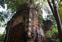 Dubrajpur: The Laxmi Janardan temple, built in 1811, with rich terracotta decoration, now in a ruinous condition
 -
 Adasimla: The Rudreshwara temple
 -
 Kolanda: The Shyama Sundar temple, all five pinnacles (ratnas) have fallen


Healthcare[edit | edit source]
In 2014, Sabang CD block had 1 rural hospital, 3 primary health centres and 1 private nursing home with total 78 beds and 10 doctors. It had 36 family welfare sub centres and 1 family welfare centre. 7,298 patients were treated indoor and 182,238 patients were treated outdoor in the hospitals, health centres and subcentres of the CD block.[13]
Sabang Rural Hospital, with 40 beds at Sabang, is the major government medical facility in the Sabang CD block. There are primary health centres at: Mohor (with 10 beds), Kharika (with 10 beds) and Uchitpur (with 4 beds).[20][21]
References[edit | edit source]
- ↑ "District Human Development Report: Paschim Medinipur" (PDF). pages 4-5 (About Paschim Medinipur), page 26 (Predominant Soil), pages 265- 268 (Identification of Flood prone areas, Names of drought prone blocks). Development and Planning Department, Government of West Bengal, 2011. Archived from the original (PDF) on 29 March 2017. Retrieved 2 January 2017.
- ↑ "District Statistical Handbook 2014 Paschim Medinipur". Tables 2.1, 2.2. Department of Planning and Statistics, Government of West Bengal. Retrieved 12 September 2020.
- ↑ "District Census Handbook: Paschim Medinipur" (PDF). Map of Paschim Medinipur with CD Block HQs and Police Stations (on the fifth page). Directorate of Census Operations, West Bengal, 2011. Retrieved 20 November 2016.
- ↑ "Directory of District, Subdivision, Panchayat Samiti/ Block and Gram Panchayats in West Bengal". Paschim Medinipur - Revised in March 2008. Panchayats and Rural Development Department, Government of West Bengal. Retrieved 1 August 2016.
- ↑ 5.0 5.1 5.2 5.3 "CD block wise Primary Census Abstract Data(PCA)". 2011 census: West Bengal – District-wise CD blocks. Registrar General and Census Commissioner, India. Retrieved 3 May 2016.
- ↑ "Provisional population totals, West Bengal, Table 4, (erstwhile) Medinipur District". Census of India 2001. Census Commission of India. Archived from the original on 28 September 2011. Retrieved 22 July 2016.
- ↑ "Provisional Population Totals, West Bengal. Table 4". Census of India 2001. Census Commission of India. Archived from the original on 27 September 2007. Retrieved 17 July 2016.
- ↑ 8.0 8.1 "Table C-01 Population by Religion: West Bengal". censusindia.gov.in. Registrar General and Census Commissioner of India. 2011.
- ↑ "ST-14 A Details of Religions Shown Under 'Other Religions And Persuasions' In Main Table". West Bengal. Registrar General and Census Commissioner, India. Retrieved 29 July 2016.
- ↑ "Table C01 Population by Religious Community: West Bengal". Registrar General and Census Commissioner of India. 2001.
- ↑ 11.0 11.1 "Table C-16 Population by Mother Tongue: West Bengal". www.censusindia.gov.in. Registrar General and Census Commissioner of India.
- ↑ 12.0 12.1 "District Human Development Report: Paschim Medinipur" (PDF). May 2011. Page 177. Development & Planning Department, Government of West Bengal. Archived from the original (PDF) on 29 March 2017. Retrieved 8 January 2017.
- ↑ 13.0 13.1 13.2 13.3 13.4 13.5 13.6 13.7 13.8 "District Statistical Handbook 2014 Paschim Medinipur". Tables 2.1, 8.2, 16.1, 17.2, 18.2, 18.1, 20.1, 21.2, 4.4, 3.1, 3.3 – arranged as per use. Department of Planning and Statistics, Government of West Bengal. Retrieved 14 September 2020.
- ↑ "District Human Development Report: South 24 Parganas". (1) Chapter 1.2, South 24 Parganas in Historical Perspective, pages 7-9 (2) Chapter 3.4, Land reforms, pages 32-33. Development & Planning Department, Government of West Bengal, 2009. Archived from the original on 5 October 2016. Retrieved 7 August 2016.
- ↑ "District Human Development Report, Paschim Medinipur" (PDF). Table 2.4, Page 28. Development and Planning Department, Government of West Bengal, May 2011. Archived from the original (PDF) on 29 March 2017. Retrieved 2 January 2017.
- ↑ "District Human Development Report: Paschim Medinipur" (PDF). Chapter V: Economic Livelihoods, pages 129-131. Development and Planning Department, Government of West Bengal, 2011. Archived from the original (PDF) on 29 March 2017. Retrieved 2 January 2017.
- ↑ "District Human Development Report: Paschim Medinipur" (PDF). May 2011. Page: 60. Development & Planning Department, Government of West Bengal. Archived from the original (PDF) on 29 March 2017. Retrieved 31 July 2016.
- ↑ "Sabang Sajanikanta Mahavidyalaya". Sabang Sajanikanta Mahavidyalaya. Archived from the original on 3 December 2016. Retrieved 28 October 2016.
- ↑ "Sabang Sajanikanta Mahaviyalaya". College Admission. Archived from the original on 29 October 2016. Retrieved 28 October 2016.
- ↑ "Health & Family Welfare Department" (PDF). Health Statistics – Rural Hospitals. Government of West Bengal. Archived from the original (PDF) on 8 October 2022. Retrieved 1 September 2020.
- ↑ "Health & Family Welfare Department" (PDF). Health Statistics – Primary Health Centres. Government of West Bengal. Archived from the original (PDF) on 21 April 2018. Retrieved 1 September 2020.