Koduru, Krishna district: Difference between revisions
Kamal Guha (talk | contribs) (Website) |
CleanupBot (talk | contribs) m (clean up) |
||
| Line 57: | Line 57: | ||
}} | }} | ||
'''Koduru''' is a village in [[Krishna district]] of the [[India]]n state of [[Andhra Pradesh]].<ref name="census" />It is the Mandal headquarters of [[Koduru mandal|Koduru Mandal]] in [[Machilipatnam revenue division|Machilipatnam Revenue Division]]. | '''Koduru''' is a village in [[Krishna district]] of the [[India]]n state of [[Andhra Pradesh]].<ref name="census" /> It is the Mandal headquarters of [[Koduru mandal|Koduru Mandal]] in [[Machilipatnam revenue division|Machilipatnam Revenue Division]]. | ||
==History== | ==History== | ||
[[NTR district]] was carved out of [[Krishna district]] in 2022. <ref>{{cite web| url = https://government.economictimes.indiatimes.com/news/governance/andhra-pradesh-govt-creates-13-new-districts-including-ntr-district-with-vijayawada-as-headquarters/89129674 | title= Andhra Pradesh govt creates 13 new districts including NTR District with Vijayawada as capital |work= Updated 26 January 2022 |publisher= ET Government | access-date = 10 September 2023}}</ref> | [[NTR district]] was carved out of [[Krishna district]] in 2022.<ref>{{cite web| url = https://government.economictimes.indiatimes.com/news/governance/andhra-pradesh-govt-creates-13-new-districts-including-ntr-district-with-vijayawada-as-headquarters/89129674 | title= Andhra Pradesh govt creates 13 new districts including NTR District with Vijayawada as capital |work= Updated 26 January 2022 |publisher= ET Government | access-date = 10 September 2023}}</ref> | ||
==Geography== | ==Geography== | ||
Koduru covers an area of 22.88 sq km. <ref name= | Koduru covers an area of 22.88 sq km.<ref name= "census">{{cite web |url = http://www.censusindia.gov.in/2011census/dchb/2816_PART_B_DCHB_KRISHNA.pdf |title = District Census Handbook, Krishna |work = Series 29, Part XII B, page 292, item 589132 |publisher = Directorate of Census Operations, Andhra Pradesh |access-date = 17 September 2023 |archive-url = https://web.archive.org/web/20160422201208/http://www.censusindia.gov.in/2011census/dchb/2816_PART_B_DCHB_KRISHNA.pdf |archive-date = 22 April 2016 |url-status = dead }}</ref> | ||
Famous places nearby includes "Sagara Sangam beach" and "Venu Gopala Swami Temple".<ref>{{cite web|title=Chapter–3 (Literates and Literacy rate) |url=http://www.censusindia.gov.in/2011census/PCA/PCA_Highlights/pca_highlights_file/India/Chapter-3.pdf|publisher=Registrar General and Census Commissioner of India|accessdate=1 September 2014|format=PDF}}</ref> | Famous places nearby includes "Sagara Sangam beach" and "Venu Gopala Swami Temple".<ref>{{cite web|title=Chapter–3 (Literates and Literacy rate) |url=http://www.censusindia.gov.in/2011census/PCA/PCA_Highlights/pca_highlights_file/India/Chapter-3.pdf|publisher=Registrar General and Census Commissioner of India|accessdate=1 September 2014|format=PDF}}</ref> | ||
==Demographics== | ==Demographics== | ||
In the 2011 census, Koduru had a population of 14,747, of which 7,423 (50%) were males and 7,324 (50%) were females. <ref name= | In the 2011 census, Koduru had a population of 14,747, of which 7,423 (50%) were males and 7,324 (50%) were females.<ref name= "census"/> | ||
Koduru had a literate population of 9,943 (67.42%). <ref name= ‘census/’> | Koduru had a literate population of 9,943 (67.42%).<ref name= "‘census/’"> | ||
== See also == | == See also == | ||
Latest revision as of 23:08, 7 October 2023
Koduru
కోడూరు | |
|---|---|
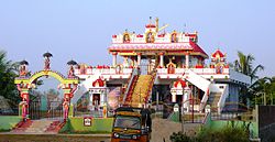
 Ayyappa Swamy Temple | |
| Coordinates: 16°00′08″N 81°02′30″E / 16.00222°N 81.04167°ECoordinates: 16°00′08″N 81°02′30″E / 16.00222°N 81.04167°E | |
| Country | India |
| State | Andhra Pradesh |
| District | Krishna |
| Mandal | Koduru mandal |
| Government | |
| • Type | Gram panchayat |
| Area | |
| • Total | 22.88 km2 (8.83 sq mi) |
| Elevation | 7 m (23 ft) |
| Population (2011)[2] | |
| • Total | 14,747 |
| • Density | 640/km2 (1,700/sq mi) |
| Language | |
| • Official | Telugu |
| Time zone | UTC+5:30 (IST) |
| PIN | 521 328 |
| Telephone code | +91–8671 |
| Vehicle registration | AP 16 U |
| Website | krishna |
Koduru is a village in Krishna district of the Indian state of Andhra Pradesh.[1] It is the Mandal headquarters of Koduru Mandal in Machilipatnam Revenue Division.
History[edit]
NTR district was carved out of Krishna district in 2022.[3]
Geography[edit]
Koduru covers an area of 22.88 sq km.[1]
Famous places nearby includes "Sagara Sangam beach" and "Venu Gopala Swami Temple".[4]
Demographics[edit]
In the 2011 census, Koduru had a population of 14,747, of which 7,423 (50%) were males and 7,324 (50%) were females.[1]
Koduru had a literate population of 9,943 (67.42%).<ref name= "‘census/’">
See also[edit]
References[edit]
- ↑ 1.0 1.1 1.2 1.3 "District Census Handbook - Krishna" (PDF). Census of India. p. 16,244. Retrieved 15 February 2016. Cite error: Invalid
<ref>tag; name "census" defined multiple times with different content - ↑ "Census 2011". The Registrar General & Census Commissioner, India. Retrieved 10 August 2014.
- ↑ "Andhra Pradesh govt creates 13 new districts including NTR District with Vijayawada as capital". Updated 26 January 2022. ET Government. Retrieved 10 September 2023.
- ↑ "Chapter–3 (Literates and Literacy rate)" (PDF). Registrar General and Census Commissioner of India. Retrieved 1 September 2014.
