Nabha State: Difference between revisions
imported>Grangjatt (→top) |
->Gotitbro No edit summary |
||
| Line 31: | Line 31: | ||
}} | }} | ||
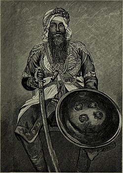
[[File:Imperial India; an artist's journals (1879) (14597378638).jpg|thumb|''Sir Hira Singh'', Raja of Nabha (c.1843-1911).]] | [[File:Imperial India; an artist's journals (1879) (14597378638).jpg|thumb|''Sir Hira Singh'', Raja of Nabha (c.1843-1911).]] | ||
'''Nabha State''',<ref>[https://dsal.uchicago.edu/reference/gazetteer/pager.html?objectid=DS405.1.I34_V18_277.gif Imperial Gazetteer of India, v. 18, p. 271.]</ref> with its capital at [[Nabha]], was one of the [[Phulkian]] [[princely state]]s of [[Punjab (British India)|Punjab]] during the [[British Raj]] in India.<ref name=EB1911>{{cite EB1911 |wstitle=Nabha |volume=19 |page=147}}</ref> | '''Nabha State''',<ref>[https://dsal.uchicago.edu/reference/gazetteer/pager.html?objectid=DS405.1.I34_V18_277.gif Imperial Gazetteer of India, v. 18, p. 271.]</ref> with its capital at [[Nabha]], was one of the [[Phulkian]] [[princely state]]s of [[Punjab (British India)|Punjab]] during the [[British Raj]] in India.<ref name=EB1911>{{cite EB1911 |wstitle=Nabha |volume=19 |page=147}}</ref> | ||
==See also== | ==See also== | ||
Latest revision as of 17:35, 6 November 2021
| Nabha State | |||||||||
|---|---|---|---|---|---|---|---|---|---|
| Princely State | |||||||||
| 1763–1947 | |||||||||
 Nabha State in a 1911 map of Ludhiana district | |||||||||
| Area | |||||||||
• 1901 | 2,502 km2 (966 sq mi) | ||||||||
| Population | |||||||||
• 1901 | 297,949 | ||||||||
| Historical era | New Imperialism | ||||||||
• Established | Template:Fdate | ||||||||
• Accession to India | Template:Fdate | ||||||||
| |||||||||
| Today part of | |||||||||
Nabha State,[1] with its capital at Nabha, was one of the Phulkian princely states of Punjab during the British Raj in India.[2]
See also[edit]
References[edit]
- ↑ Imperial Gazetteer of India, v. 18, p. 271.
- ↑ Chisholm, Hugh, ed. (1911). . Encyclopædia Britannica. Vol. 19 (11th ed.). Cambridge University Press. p. 147.


