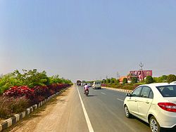
Gannavaram
Thank you for being part of the Bharatpedia family! 0% transparency: ₹0 raised out of ₹100,000 (0 supporter) |
Gannavaram | |
|---|---|
Neighbourhood | |
 Gannavaram town | |
| Coordinates: 16°32′00″N 80°48′00″E / 16.5333°N 80.8000°ECoordinates: 16°32′00″N 80°48′00″E / 16.5333°N 80.8000°E | |
| Country | India |
| State | Andhra Pradesh |
| District | Krishna |
| Elevation | 12 m (39 ft) |
| Population (2011)[1] | |
| • Total | 20,728 |
| Language | |
| • Official | Telugu |
| Time zone | UTC+5:30 (IST) |
| PIN | 521101 |
| Telephone code | +91–8676 |
| Vehicle registration | AP–16 |
Gannavaram is a neighbourhood of Vijayawada in Krishna district of the Indian state of Andhra Pradesh. As per the G.O. No. M.S.104 (dated:23-03-2017), Municipal Administration and Urban Development Department, it became a part of Vijayawada metropolitan area.[2][3] It is also the mandal headquarters of Gannavaram mandal, administered under Nuzvid revenue division.[4][5]
Etymology
The name Gannavaram is based on the traditional Sanskrit words "Ganna" meaning Sugarcane and "Varam" meaning 'blessing'. Historically Gannavaram used to be a primarily sugarcane-producing establishment. Hence named Gannavaram, 'blessed with sugarcane'.
History
Krishna district was formed by renaming Machilipatnam district and adding certain taluks of Guntur district in 1859. Krishna district was divided into Krishna and Godavari districts in 1925. During the reorganisation of Andhra Pradesh Krishna district was further divided into Krishna and NTR districts. [6]
Krishna district has 25 mandals spread across three revenue divisions – Machilipatnam revenue division, Gudivada revenue division and Vuyyuru revenue division. [7]
Transport

APSRTC operates buses from Gannavaram bus station which also has a sus garage/bus depot.[8][9] Gannavaram railway station is one of the satellite railway stations of the Vijayawada Junction.[10] The airport is located at Gannavaram 13 KM from Vijayawada. Road connectivity is available from Gannavaram to Vijayawada.
Education
The primary and secondary school education is imparted by government, aided and private schools, under the School Education Department of the state.[11][12] The medium of instruction followed by different schools are English and Telugu.
The National Institute of Disaster Management was planned to be set up at the town by the higher education department of the state.[13]
See also
References
- ↑ "Census 2011". The Registrar General & Census Commissioner, India. Retrieved 14 September 2014.
- ↑ Staff Reporter. "Vijayawada, 19 other contiguous areas notified as Metropolitan Area". The Hindu. Retrieved 27 March 2017.
- ↑ "Welcome to Government Order Issue Register". goir.ap.gov.in. Retrieved 27 March 2017.
- ↑ "Krishna District Mandals" (PDF). Census of India. pp. 495, 526–527. Retrieved 19 January 2015.
- ↑ "Administrative Setup". Krishna District Official Website. National Informatics Centre. Archived from the original on 20 October 2014. Retrieved 9 February 2015.
- ↑ "Krishna district". About District > History. Government of Andhra Pradesh. Retrieved 15 January 2024.
- ↑ "Krishna district profile - AP Government - 4 April 2022" (PDF).
- ↑ "Bus Stations in Districts". Andhra Pradesh State Road Transport Corporation. Archived from the original on 22 March 2016. Retrieved 8 March 2016.
- ↑ Sujatha Varma, P (7 February 2016). "RTC offers a 'sweet' journey". The Hindu. Vijayawada. Retrieved 8 March 2016.
- ↑ "Train services to be partially affected for nine days". The Hindu. Retrieved 20 April 2017.
- ↑ "School Education Department" (PDF). School Education Department, Government of Andhra Pradesh. Archived from the original (PDF) on 19 March 2016. Retrieved 7 November 2016.
- ↑ "The Department of School Education - Official AP State Government Portal | AP State Portal". www.ap.gov.in. Archived from the original on 7 November 2016. Retrieved 7 November 2016.
- ↑ Maitreyi, M. l Melly (20 February 2016). "Higher education institutions: State fast tracks process". The Hindu. Retrieved 23 September 2016.

