Mipi
Mipido | |
|---|---|
Village | |
 Mipi Location in Arunachal Pradesh, India  Mipi Mipi (India) | |
| Coordinates: 28°57′01″N 95°48′52″E / 28.95029°N 95.81444°E | |
| Country | |
| State | File:..Arunachal Pradesh Flag(INDIA).png Arunachal Pradesh |
| District | Dibang Valley |
| Sub-division | Anini |
| Block | Mipi-Anini-Alinye |
| Circle | Mipi |
| Population (2011) | |
| • Total | 19[1] |
| Time zone | UTC+5:30 (IST) |
Mipi is a village and the headquarters of an eponymous circle in Dibang Valley district of the Indian state of Arunachal Pradesh. Mipi HQ is located near the confluence of Andra River and Mathun River, tributaries of Dibang River.
History[edit | edit source]
Frederick Marshman Bailey passed through Mipi in March 1913. He describes the presence of Tibetans who had, years before, supposedly travelled in search of Pemako. Unsuccessful, they started returning to Tibet in 1909. By 1913, when Bailey visited Mipi, only those too old or ill to make the journey back to Tibet remained.[2][3] They were soon wiped out by the Idu.[4] Mipi has historically seen conflict between the Khamba and Idu tribes.[5] In 2017 British traveller Antonia Bolingbroke-Kent passed through Mipi, "Now Mipi was a tiny Idu settlement, just a few houses and a helipad splayed over a grassy spur above the river, girdled by an arc of trees."[2][3]
About[edit | edit source]
Mipi HQ has a population of 19 by the 2011 census.[1] The sub-district, Mipi Circle, has 102 households.[1] Anini Circle and Mipi Circle together together make up the Anini-Mipi community development block.[1] Following administrative changes, the block has been changed to Mipi-Anini-Alinye, adding Dambeun circle.[6]
| District | Sub-division | Block[6] | Circle[6] | Villages[7] |
|---|---|---|---|---|
| Dibang Valley district | Anini | Mipi-Anini-Alinye | Mipi | Adali, Biyanli, Brango, Charkilo Tapo, Ebeli, Elambro, Emuli, Egulin, Maro, Maronli, Mipi, Mipi Hq, Mipido |
Tourist locations include Mathun Valley.[8]
Maps[edit | edit source]
Lua error in Module:OSM_Location_map at line 1984: attempt to index field 'wikibase' (a nil value).
Other[edit | edit source]
-
 Mipi on a 1967 US Defense Mapping Agency map
 -
 Mipi by Morshead and Bailey, 1914
 -
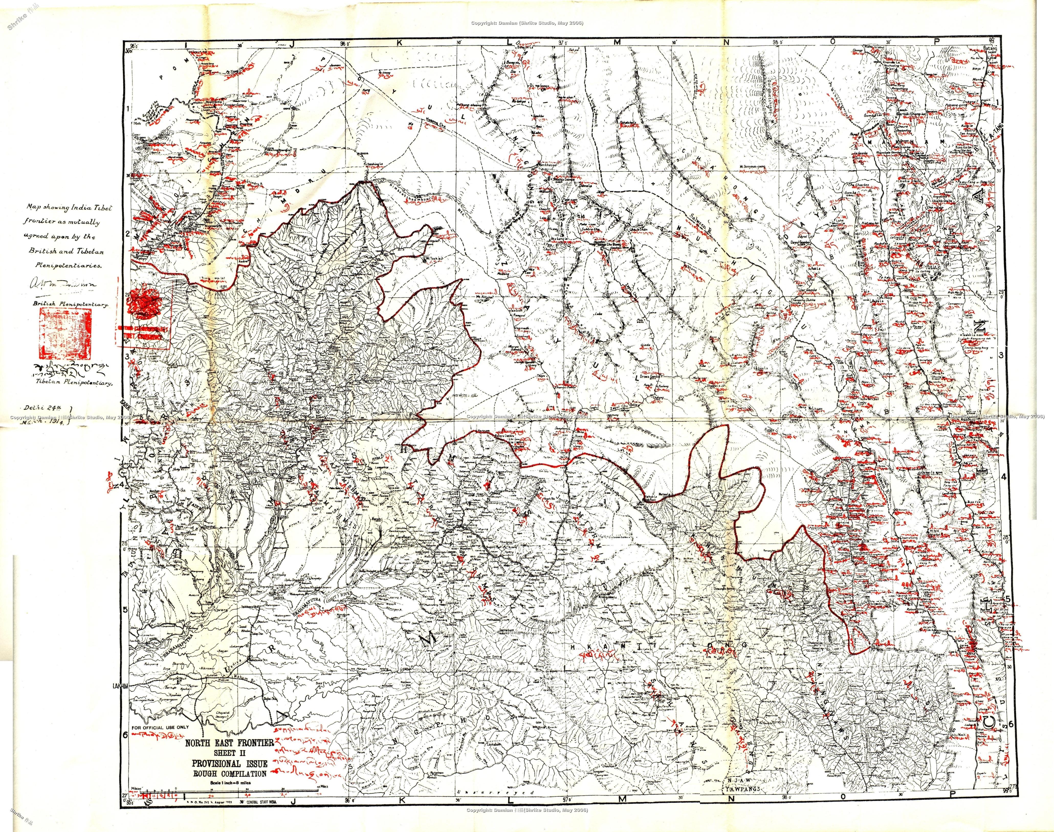 Mipi on the Simla Accord Treaty map, 1914


.png)
References[edit | edit source]
- ↑ 1.0 1.1 1.2 1.3 District Census Handbook. Dibang Valley. Directorate of Census Operations, Arunachal Pradesh, 2011. pp. 9, 42
- ↑ 2.0 2.1 Antonia Bolingbroke-Kent, Land of the Dawn-lit Mountains (2017), pp. 91-92.
- ↑ 3.0 3.1 Bolingbroke-Kent, Antonia (19 July 2017). "Arunachal Pradesh: With the Idu Mishimi". Outlook Traveller. Outlook India. Retrieved 2021-07-14.
{{cite web}}: CS1 maint: url-status (link) - ↑ Lohit District, Gazetteer of India (1978), pp. 56.
- ↑ State Gazetteer of Arunachal Pradesh (2010), pp. 180-181.
- ↑ 6.0 6.1 6.2 "Subdivision & Blocks, Dibang Valley". Dibang Valley District, Government of Arunachal Pradesh. Retrieved 2021-07-14.
{{cite web}}: CS1 maint: url-status (link) - ↑ "Villages and Panchayats, Mipi-Anini-Alinye Block, Dibang Valley". Dibang Valley District, Government of Arunachal Pradesh. Retrieved 2021-07-14.
{{cite web}}: CS1 maint: url-status (link) - ↑ "Mathun Valley (Mipi)". Dibang Valley District, Government of Arunachal Pradesh. National Informatics Centre, Ministry Of Electronics & Information Technology, Government Of India. Retrieved 2021-07-14.
{{cite web}}: CS1 maint: url-status (link)
Bibliography
- Bolingbroke-Kent, Antonia (2017). Land of the Dawn-lit Mountains. Simon & Schuster. ISBN 9781471156571.
- Choudhry, S. Dutta, ed. (1978), Lohit District, Arunachal Pradesh, Gazetteer of India, Government of Arunachal Pradesh
- Kri, Sokhep, ed. (2010), State Gazetteer of Arunachal Pradesh (PDF), vol. 1, Government of Arunachal Pradesh, ISBN 9788190658737