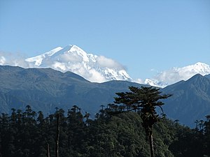
Kangto
| Kangto | |
|---|---|
| Kanggardo Rize | |
 | |
| Highest point | |
| Elevation | 7,060 m (23,160 ft) [1] |
| Prominence | 2,195 m (7,201 ft) [2] |
| Listing | Ultra List of Indian states and territories by highest point |
| Coordinates | 27°51′54″N 92°31′57″E / 27.86500°N 92.53250°ECoordinates: 27°51′54″N 92°31′57″E / 27.86500°N 92.53250°E [2] |
| Geography | |
Lua error in Module:Location_map at line 526: Unable to find the specified location map definition: "Module:Location map/data/China Tibet topography" does not exist.
| |
| Location | Arunachal Pradesh, India Shannan Prefecture, Tibet |
| Parent range | Eastern Himalayas |
Kangto (also known as Kanggardo Rize) at 7,060 metres (23,163 ft) is a mountain of the Eastern Himalayas located in the Indian state of Arunachal Pradesh and it shares its border with the Tibet Autonomous Region of China.[2] It is the highest point in Arunachal Pradesh.[3] The area in which Kangto is located lies in the Lada circle of East Kameng district of the state. On the Chinese side, it lies in Cona County of Shannan Prefecture, Tibet.
It is a virgin peak.[clarification needed] Mount Kangto is the source of the Pachuk river, one of the main tributaries of the Kameng river in East Kameng district.
A joint expedition team of ITBP and Indian Mountaineering Foundation had established a base camp at 9,920 feet on the banks of Pachuk river on October 21, 2017.[4] All earlier attempts to reach the base of the peak were unsuccessful.[5][6][7]
See also[edit]
List of Ultras of the Himalayas
References[edit]
- ↑ "Archived copy". Archived from the original on 6 November 2005. Retrieved 7 September 2011.
{{cite web}}: CS1 maint: archived copy as title (link) - ↑ 2.0 2.1 2.2 "Himalaya of Nepal, Bhutan, Sikkim and adjoining region of Tibet" Peaklist.org. Retrieved 2012-01-24.
- ↑ "Governor flagged off Mount Kangto expedition" (PDF). arunachalpradesh.gov.in. 29 September 2014. p. 1. Archived from the original (PDF) on 18 May 2015. Retrieved 14 March 2019.
- ↑ IANS (5 May 2017). "Arunachal CM receives Mt Kangto exploration team". Business Standard India. Retrieved 24 September 2020.
- ↑ "ITBP-IMF expedition team first to scale Mt Kangto base". The Hindu. PTI. 6 November 2016. ISSN 0971-751X. Retrieved 24 September 2020.
{{cite news}}: CS1 maint: others (link) - ↑ Desai, Shweta (20 November 2016). "ITBP's Mt Kangto expedition in Arunachal may annoy China". DNA India. Retrieved 24 September 2020.
- ↑ "ITBP-IMF expedition team first to scale Mt Kangto base". The Economic Times. Retrieved 24 September 2020.