


Mandi district | |
|---|---|
.svg) Location of Mandi district in Himachal Pradesh | |
| Country | |
| State | File:Himachal Pradesh Flag, India.png Himachal Pradesh |
| Headquarters | Mandi, India |
| Area | |
| • Total | 3,951 km2 (1,525 sq mi) |
| Population (2011) | |
| • Total | 999,777 |
| • Density | 250/km2 (660/sq mi) |
| Time zone | UTC+05:30 (IST) |
| Major highways | NH 3, NH 154 |
| Website | http://hpmandi.nic.in/ |

Mandi district is one of the central districts of Himachal Pradesh state in northern India. The town of Mandi is the headquarters of the district. The town has mythological and historical significance and boasts of a unique temple architecture. It is referred to as Chhoti Kashi as there are many ancient temples in the city and on the banks of river Beas.
The town is an important commercial hub of the state. It is a major transit route to Kullu-Manali and other adjoining places from NH 3 (Atari - Manali- Leh) and NH-154 (Pathankot-Sundernagar-Bilaspur and further up to Chandigarh ). Sundarnagar is one of the emerging towns of the district.
The main native language is Mandeali.[1]
As of 2011 it is the second most populous district of Himachal Pradesh (out of 12), after Kangra.[2]
History and geography[edit | edit source]

Mandi district was formed after the merger of Mandi State (Mandi) and Suket State, two princely states on 15 April 1948. This coincided with the formation of the Union territory of Himachal Pradesh. The state attained its full statehood later. Mandi town was named after its resident saint Mandavya Rishi.
Mandi is almost at the geographical centre of Himachal, lying along the left bank of the river Beas in the foothills of Shivalik ranges. The town has an altitude of 760 metres (2,495 ft) from the sea level. Comprising the two erstwhile states of Mandi and Suket, Mandi derives its name 'mandi' or 'market' as it was a major trade route from Ladakh to locations in Punjab such as Hoshiarpur and other places.
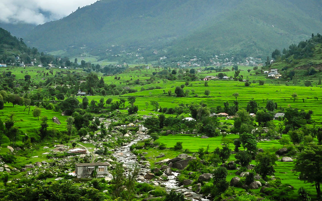
Here, during the days of yore, the pious rishi, Mandavaya, performed long and severe penance and practised austerities on his body, on the bank of the river Beas, near the present Mandi town. The story indicates the antiquity of this temple town, surrounded by hills, clad in pines. There is a large plain which has grain fields and orchards, between Mandi and Sundernagar. Known for its temples, Mandi is the home to a number of carved stone edifices each with an elaborate shikhara, or spire, among them Bhutnath, Trilokinath, Panchvaktra and Shyamakoli at Tarna hill. Also on the hill, there is a new temple dedicated to Tarna Devi, overlooking the valley and giving a panoramic view. The Beas valley is broad near Mandi, and there are a number of striking vales such as those of Uhl and Ran Khad.
The fruit tree cover in Mandi is about 15 percent of the total area under fruit tree cover in Himachal Pradesh. Mandi raw silk has acquired wide fame and the rock salt mines at Drang and Guma are special features of the district economy. With abundant deposit of rock salt and limestone, possibilities are being investigated for the existence of magnasite coal and china clay.
A transit for visitors to Kullu, Manali, Lahaul and Spiti, Dharamsala, Kangra, etc., it is approachable from Pathankot (215 km or 132-mile), Chandigarh (202 km or 125 miles) and Shimla (158 km or 98 miles). On either side of the road, there are rock hill sides rising perpendicularly to more than 300 metres (1,000 ft).
Lakes of Mandi district[edit | edit source]
- Rewalsar Lake
- Prashar Lake
- Macchial Lake
- Pandoh Dam
- Barot Lake
- Kamru Nag Lake
Demographics[edit | edit source]
According to the 2011 census Mandi district has a population of 999,777,[2] roughly equal to the nation of Fiji[4] or the US state of Montana.[5] This gives it a ranking of 446th in India (out of a total of 640).[2] The district has a population density of 253 inhabitants per square kilometre (660/sq mi).[2] Its population growth rate over the decade 2001-2011 was 10.89%.[2] Mandi has a sex ratio of 1012 females for every 1000 males[2] and a literacy rate of 82.81%.[2]
At the 2011 census, 59% of the population in the district identified their first language as Mandeali, 33% opted for Pahari (a term broadly applicable to most Indo-Aryan languages of Himachal and Uttarakhand), while 4.1% chose Hindi, 0.66% – Punjabi and 0.47% – Kangri.[6]
| Year | Pop. | ±% p.a. |
|---|---|---|
| 1901 | 228,721 | — |
| 1911 | 236,038 | +0.32% |
| 1921 | 239,376 | +0.14% |
| 1931 | 265,873 | +1.06% |
| 1941 | 303,685 | +1.34% |
| 1951 | 310,626 | +0.23% |
| 1961 | 384,259 | +2.15% |
| 1971 | 515,180 | +2.98% |
| 1981 | 644,827 | +2.27% |
| 1991 | 776,372 | +1.87% |
| 2001 | 901,344 | +1.50% |
| 2011 | 999,777 | +1.04% |
| source:[7] | ||
Subdivisions[edit | edit source]
Villages in the district include Janjheli. It is near Kullu-Manali, around 80 km from Bhunter Airport, 90 km from Kullu and 67 km from Mandi. It has thick forests and springs and is a trekking/hiking outpost. Shikari Devi is a tourist spot. It hosts Himachal Cultural Village, an ethnic village highlighting the culture of Himachal Pradesh.[8]
General information[edit | edit source]

- Area: 3950 km2
- Population: 999,777
- Language: Hindi, English, Pahari and Mandyali are understood and spoken by the people engaged in tourism trade.
- Tehsils: Mandi, Chachyot, Thunag, Karsog, Kotli Jogindernagar, Padhar, Ladbhadol, Sundernagar, Sarkaghat, Balh, Aut, Nihri, Sandhol, Dharampur, Baldwara and Balichowki.
- Sub-Tehsils: Pangna, Chattari, Makreri.
- Sub divisions: Mandi Urban, Mandi Rural, Chachyot, Jogindernagar, Padhar, Sarkaghat, Karsog, Thunag, Balh and Sundernagar.
Approach[edit | edit source]
- Train: The nearest railway stations are Joginder Nagar and Shimla by narrow gauge train, Chandigarh and Kalka by broad gauge train which are connected by regular bus services. The closest railhead is in Kiratpur and Una which 125 km and 144 km away from Mandi respectively.
- Road: Mandi is approachable by road from Shimla, Chandigarh, Joginder Nagar, Pathankot and Delhi. There are regular bus services linking it to the other towns like Manali, Palampur and Dharamshala. Mandi is connected to Chandigarh by National Highway 154 and 205 . The distance between Mandi and Chandigarh is 200 kilometers. Government buses are available throughout the day to Chandigarh. It takes about 5–6 hours to commute to Chandigarh by bus and around 3–4 hours if a private vehicle is taken. Mandi is connected to Shimla, the capital of Himachal Pradesh. The distance between Shimla and Mandi is about 147 kilometers and it takes about 5 hours.
- Airplane: The nearest airport is at Bhuntar in Kullu District, about 50 km from the district.
Places of interest[edit | edit source]
.jpg)

The historic town of Mandi is built along the banks of the river Beas. It has long been an important commercial centre, and the sage Mandvya is said to have meditated here. This one-time capital of the princely state of Mandi is a fast developing town that retains much of its original charm and character. Today, it is a district headquarters. Mandi is renowned for its 81 old stone temples and their enormous range of fine carving. Because of this, it is often called the "Varanasi of the Hills." The town has the remains of old palaces and notable examples of colonial architecture. Mandi is the gateway to the Kullu valley and acts as the base for several exciting excursions.
Dev Balakameshwar Temple[edit | edit source]
The state of Himachal Pradesh is said to be protected and sheltered by the power of numerous local deities. Every region in Himachal believes in a distinct deity. All the faith of the local people is vested in these local gods called 'devta' in the regional language. Each of these deities has its individual identity with some peculiar personality traits. Dev Balakameshwar temple is located 13 km from Mandi in Devdhar village. This devta is the son of Dev Kamru Nag.
Bhootnath Temple[edit | edit source]
Practically synonymous with Mandi and located in its very heart, Bhootnath Temple is as old as the town itself and dates to the 1520s. In March, the festival of Shivratri is a major event and the Bhootnath Temple is its focus. For an entire week, the town celebrates the arrival of hundreds of local deities on elaborately decorated palanquins.
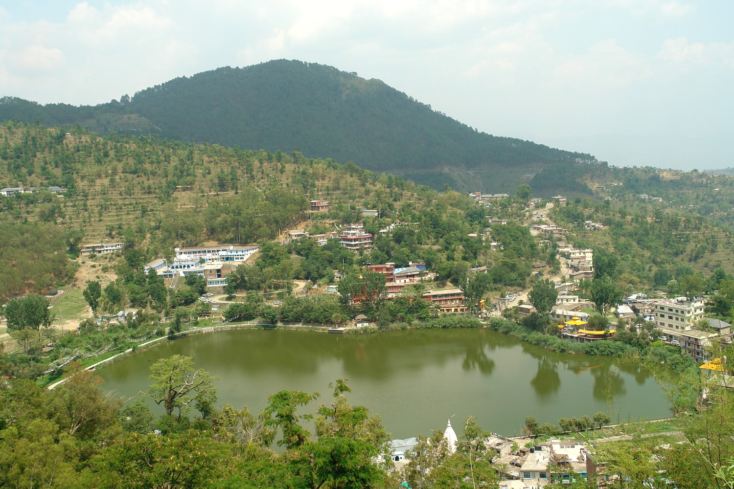
Rewalsar Lake[edit | edit source]
About 25 km from Mandi, 14 km from Ner Chowk is the Rewalsar lake, famous for its floating islands of reed. It is believed that all seven of them can be moved by prayer or breeze. There are three shrines here: a Buddhist monastery, where elaborate rituals are performed, a Sikh gurudwara, and a Hindu temple. It was from this place that the sage Padma Sambhava, a zealous teacher of Buddhism, left as a missionary to preach the doctrine of "the enlightened" in Tibet. Lying in a mountain hollow, the lake is held sacred to all three communities; boating facilities are available. A tourist inn maintained by HPTDC provides accommodation and Indian cuisine.
Prashar Lake[edit | edit source]

Prashar Lake lies 49 km north of Mandi, with a three-storied pagoda-like temple dedicated to the sage Prashar. It was made in the 13th or 14th century by Maharaja Bansen. The temple is a bit tilted due to a heavy earthquake. There are 2 annual fairs at the temple, held in April and June. There is a small pond nearby, a small piece of land floats on it, its position changes by the change of seasons.
Joginder Nagar[edit | edit source]
The large hydro-electric project in Joginder Nagar has an electric trolley takes visitors up the steep, rocky face of a 2,500 metres-high (8,202 ft) mountain and drops sharply on the other side to Barot, where the reservoir is.
The railway line goes up to the power station, the water rushing down from the reservoir at Barot in the Uhl river through penstock pipes going down nearly a thousand metres (3,280 ft). For tourists who go up to Barot by the trolley, there is a comfortable rest house of the electricity department. The roads extend beyond to Mandi and passes the Larji gorge to the Kullu valley.
Bassi power station is 8 kilometres from Joginder Nagar. Next to it is Machhial where fishing is not permitted as it is considered a holy sacred spot. It is a common as a feeding spot for fish.
Lad-Bharol: 25 km from Joginder Nagar, santan dati maa simsa mata mandir in nearby Lad-Bharol, 7 km from Lad-Bharol, Nageshwar Mahadev Coudh is near Bharol. The Triveni Mahadev where three rivers Bias, Binwa and one local are meeting with each other. A very ancient Lord Shiva temple is there at the intersecting of three rivers.[clarification needed]
Santan Datri Man Shimsha (Sharda) is at Village Shimashjust on the top of hill of Triveni Mahadev. Childless women pray and sleep inside the temple in Navratras and maa blessed them with different fruits indicating boy or girl.
Nageshwar Mahadev Kud is in the foothills of village shimash and there is ancient goofa in which lot of natural shivlings. A unique and natural combined shivling of Shiva and Parvati, a unique and natural Sculpture of Nandi Bail and finally a unique and natural shivling with NAG; that is why it is known as Nageshwar Mahadev.[citation needed]
Sundar Nagar[edit | edit source]
Famous for its temples, 26 km from Mandi towards Shimla and at a height of 1,174 metres on the raised edge of a fertile valley, the town of Sundar Nagar is known for its shady walks amidst towering trees.[tone] On top of a hill and visited by thousands of devotees every year, is the Sukhdev Vatika and temple of Mahamaya.
The biggest hydro-electric project in all Asia, the Beas-Sutlej project, irrigating nearly one-fourth of the northern plains of India, has brought unprecedented prosperity to Sunder Nagar. The Beas-Sutlej link colony is the biggest colony in Himachal Pradesh.
Janjehli[edit | edit source]
At a distance of 80 km from Mandi, Janjehli is a paradise for hikers, offering treks up to a height of 3,300 metres. All the road is motorable and fun to ride. The road is connected to Karsog which remains open all seasons except some weeks of winter. It takes about 3 hours to reach here from Mandi via Baggi, Chail Chowk and Thunag (Tehsil Headquarters). In the midst of thick forest, forests (15 km from Gohar) is Bajahi. From here Janjehli is a scant 20 km away through bridle path. Chindi and Karsog are places for meditation.[citation needed] Janlehli is popular for adventure activities like-trekking, night safari, mountaineering, and skiing. At the distance of 10 km from janjehli is the Shikari Mata temple.
The temple is all about Goddess "Shikari Devi" and people visits here in masses to accolades for their well-being.[citation needed]
Barot[edit | edit source]

Barot (Himachal Pradesh) is a picnic spot and tourist location in Mandi district in the Indian state of Himachal Pradesh. It is situated 40 km from Jogindernagar and 66 km from Mandi, the district headquarters. The road to Barot branches off at Jogindernagar-Mandi high ways and from Jogindernagar the distance is 40 km. It was possible to use the trolley from Jogindernagar which reduces the distance to 12 km. However, the trolley has not been operational since about 2010. The route includes terraced fields and thick cedar forests, rising to Jhatingri at the hilltop. The remains of the summer palace of the former rulers of Mandi are located here. The road descends steeply along a precipitous gorge to the little village of Tikkan on the Uhl River. The road winds along the right bank of the Uhl up to Barot. The town has a range of outdoor activities, including a trout breeding centre from where fish are released into the Uhl. A 30 km section of the river is used for angling. Accommodation at Barot includes the PWD Resthouse, the Forest Resthouse and a number of private hotels and homestays.
Barot also forms the gateway to the Nargu Wildlife Sanctuary which lies across the Uhl. The sanctuary is home to the monal, black bear and ghoral. Within it are forest rest houses at Thaltuckhod and Silbandhwari. Through woods of cedar and pine a trek route cuts across the sanctuary to Kullu.
Kotli[edit | edit source]
Kotli is small town just 22 km from Mandi city. Kotli is a tehsil of Mandi Himachal Pradesh. Kotli and the surrounding area are known as Tungal Valley and has great importance. NH 003 (old number NH 70) from Mandi to Jalandhar passes through here. Kotli has almost every facility like Offices of tehsil, IPH, HP PWD & Electricity Board Sub Divisions, Govt College, ITI, Schools, Post Office, Hospital, etc. Kotli is the important and main village of tungal valley Kotli is also a Gram Panchayat. There are various temples in the surrounding vicinity e.g. Jhumba ri Jogini temple at Jhumb Dhar at about 2000 meters above sea level and located around 15 km away from kotli and 28 km from Mandi town, Janitri Mata (14 km from Kotli), Mahan Dev (14 km), Jagad Dev (3 km), Rachera Dev (2 km). Mahan dev is also known as Bada Dev.
Scope of Tourism: there are some places near Kotli like Jhumb dhar, janitri dhar, rachera dev, where tourist can visit and enjoy the picnic, but due to lack of infrastructure and hotels very few people visit here. The PWD & Forest Resthouses are available for night stay at Kotli. Most of the population here are literate and the main occupation is agriculture. Govt and private services are also sources of employment. Many families have one member serving in the Indian Army. Arnodi Khad flows along the Tungal Valley to meet the River Beas at Kun ka Tar. Famous fairs are the Saigaloo nar wadi, Mahan Dev, and Janitri Devi.
Dharmpur[edit | edit source]
Dharmpur is mainly famous for its situation between the comical shaped Lower Shivalik Hills and Beas Riverside, though hot weather is prevalent due to its low altitude .[citation needed] At a distance of 68 kilometers from Mandi on (Mandi-Hamirpur-Amritsar NH3) Dharmpur is a sub-tehsil of Mandi district. It is mainly famous for temple of Baba Kamlahia, Rishi Pandla Dev, Jalpa Mata and 'Kandhapattan' famous for crematorium are located in Dharmpur sub-division.[citation needed]
Kamlah Fort[edit | edit source]
Kamlah Fort is a 17th-century fort located near Kamlah village, west of Mandi town. It was probably constructed in 1625 by Raja Suraj Sen of Mandi.
Education[edit | edit source]
Universities and colleges[edit | edit source]

 IIT Mandi Campus Jan 2020
- Indian Institute of Technology Mandi (IIT Mandi)
- Jawaharlal Nehru Government Engineering College
- Sardar Vallabhbhai Patel Cluster University
- Shri Lal Bahadur Shastri Government Medical College & Hospital Mandi
- College of Horticulture and Centre of Excellence for Horticulture Research and Extension, Thunag
- Atal Bihari Vajpayee University of Medicine and Health Sciences (upcoming)
Schools[edit | edit source]
Polytechnics[edit | edit source]
Sports[edit | edit source]
The district is home to the Bandy Federation of India[9] which is a member of the IOC recognized[10] Federation of International Bandy.
See also[edit | edit source]
References[edit | edit source]
- ↑ Lewis, M. Paul (2009). "Mandeali". Ethnologue: Languages of the World, Sixteenth edition. Dallas, TX: SIL International. Retrieved 3 October 2009.
- ↑ 2.0 2.1 2.2 2.3 2.4 2.5 2.6 "District Census 2011". Census2011.co.in. 2011. Retrieved 30 September 2011.
- ↑ "Mandi district Population". Census India. Retrieved 11 July 2021.
- ↑ US Directorate of Intelligence. "Country Comparison:Population". Retrieved 1 October 2011.
Fiji 883,125 July 2011 est.
- ↑ "2010 Resident Population Data". U. S. Census Bureau. Archived from the original on 19 October 2013. Retrieved 30 September 2011.
Montana 989,415
- ↑ C-16 Population By Mother Tongue – Himachal Pradesh (Report). Office of the Registrar General & Census Commissioner, India. Retrieved 6 October 2019.
- ↑ Decadal Variation In Population Since 1901
- ↑ "Archived copy". Archived from the original on 22 August 2018. Retrieved 23 March 2020.
{{cite web}}: CS1 maint: archived copy as title (link) - ↑ "Archived copy". Archived from the original on 4 October 2009. Retrieved 2 November 2009.
{{cite web}}: CS1 maint: archived copy as title (link) - ↑ "Archived copy". Archived from the original on 3 October 2009. Retrieved 2 September 2011.
{{cite web}}: CS1 maint: archived copy as title (link)
External links[edit | edit source]
- Mandi district website
- DISTRICT PROFILE
- CULTURAL & TOURISM HERITAGE OF THE DISTT
- Janjehli Valley Himachal Pradesh
Places adjacent to Mandi district | |
|---|---|
Template:Mandi district Template:Districts of Himachal Pradesh Template:Geo HP Template:Kullu Manali Circuit