Biccavolu mandal
Biccavolu mandal | |
|---|---|
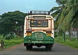
 APS RTC bus near Biccavolu | |
| Coordinates: 16°57′00″N 82°03′00″E / 16.9500°N 82.0500°ECoordinates: 16°57′00″N 82°03′00″E / 16.9500°N 82.0500°E | |
| Country | India |
| State | Andhra Pradesh |
| District | East Godavari |
| Headquarters | Biccavolu |
| Government | |
| • Body | Mandal Parishad |
| Area | |
| • Total | 100.58 km2 (38.83 sq mi) |
| Population (2011)[2] | |
| • Total | 70,277 |
| • Density | 700/km2 (1,800/sq mi) |
| Language | |
| • Official | Telugu |
| Time zone | UTC+5:30 (IST) |
Biccavolu mandal is one of the 19 mandals in East Godavari district of the Indian state of Andhra Pradesh. It is under the administration of Rajahmundry revenue division and the headquarters are located at Biccavolu village.[3]Biccavolu Mandal is bounded by Rayavaram Mandal towards South, Pedapudi Mandal towards East, Anaparthy Mandal towards west, Ramachandrapuram Mandal towards north .[4] It is located ata distance of 41 kilometres from Rajahhmundry.
History[edit | edit source]
Rajahmundry district was formed in 1823 and in 1859 bifurcated into Godavari District and Krishna district. In 1925, Godavari district was split into East Godavari district and West Godavari district.[5][6]
The reorganisation of the districts in 2022 increased the number of districts in Andhra Pradesh from 13 to 26.[7]
Demographics[edit | edit source]
As of 2011[update] census, the mandal had a population of 67,717 with 17,478 Households. The total population constitute, 33,642 males and 34,075 females, Average sex ratio of Biccavolu mandal is 1026 females per 1000 males. 6,952 children are in the age group of 0–6 years, of which 3,512 are boys and 3,440 are girls. Children sex ratio of Biccavolu is 979.[clarification needed] The average literacy rate stands at 68.31% of which male has 72.36% and female has 72.36%.[2]
Governance[edit | edit source]
Administration[edit | edit source]
As of 2011[update] census, the mandal has twenty revenue villages, thirteen gram panchayats, of which all of them are villages.[1] Rallakhandrika is the smallest Village and Biccavolu is the biggest Village in terms of population.[8][9]
The settlements in the mandal are listed below:[10]
- Arikarevula
- Biccavolu
- Balabhadrapuram
- Biccavolu
- Illapalle
- Kapavaram
- Komaripalem
- Konkuduru
- Melluru
- Pandalapaka
- Rangapuram
- Thummalapalle
- Tossipudi
- Voolapalle
Politics[edit | edit source]
Biccavolu mandal is one of the mandals under Anaparthy (Assembly constituency), which in turn represents Rajahmundry (Lok Sabha constituency) of Andhra Pradesh.[11]
Education[edit | edit source]
The primary and secondary school education is imparted by mandal parishad, zilla parishad, government and private schools, which are both aided and unaided, under the administration of the School Education Department of the state.[12] The medium of instruction followed by different schools are English, Telugu.
Important colleges in Biccavolu are Sree Rama Private Industrial Training Institute and Adarsa Jr College. There are many schools in Biccavolu. Netaji Public High school and SriRama High school teaches in English medium whereas, Zilla Parishad High Schools in Telugu medium.
See also[edit | edit source]
References[edit | edit source]
- ↑ 1.0 1.1 "District Census Handbook - East Godavari" (PDF). Census of India. Retrieved 5 November 2016.
- ↑ 2.0 2.1 "Census 2011". The Registrar General & Census Commissioner, India. Retrieved 26 July 2014.
- ↑ "East Godavari District". About District > Administrative Setup > Mandal. Government of Andhra Pradesh. Retrieved 19 December 2023.
- ↑ "Mandals in East Godavari district". aponline.gov.in. Retrieved 5 November 2016.[permanent dead link]
- ↑ "Rajamahendravaram History". Rajamahendravaram Municipal Corporation. Government of Andhra Pradesh. Retrieved 20 December 2023.
- ↑ "History of East Godavari chapter". INTACH East Godavari chapter. Retrieved 20 December 2023.
- ↑ "13 new districts inaugurated in Andhra Pradesh; Full list here". Published on: April 4, 2022. Deccan Chronicle. Retrieved 20 December 2023.
- ↑ Cite error: Invalid
<ref>tag; no text was provided for refs namedmap - ↑ "Sub-District Details of East Godavari District". The Registrar General & Census Commissioner, India. Archived from the original on 19 July 2014. Retrieved 6 November 2016.
- ↑ "Abbreviations used". censusindia.gov.in. Archived from the original on 17 June 2007. Retrieved 6 November 2016.
- ↑ "Delimitation of Parliamentary and Assembly Constituencies Order, 2008" (PDF). Election Commission of India. Retrieved 6 November 2016.
- ↑ "Constitution of Working Groups" (PDF). School Education Department, Government of Andhra Pradesh. Archived from the original (PDF) on 21 October 2016. Retrieved 23 September 2016.
