

>Monkbot m Task 18 (cosmetic): eval 1 template: hyphenate params (1×); |
minor cleanup lead for accuracy and corrected details |
||
| Line 1: | Line 1: | ||
{{Short description|Fort in Maharashtra, India}} | |||
{{Infobox mountain | {{Infobox mountain | ||
| name = Jangali Jayagad | | name = Jangali Jayagad | ||
| Line 17: | Line 18: | ||
| easiest_route = Hike | | easiest_route = Hike | ||
}} | }} | ||
'''Jangali Jayagad''' is located in [[Patan, Maharashtra|Patan taluka]] of [[Satara District]]. This fort is situated on a hilly spur from the main ridge of Sahyadri. This fort is less visited due to its occurrence in [[Koyna sanctuary|Koyana Wildlife sanctuary]]. The nearby village is Nawja. The trek to the fort can easily be completed in a day. | |||
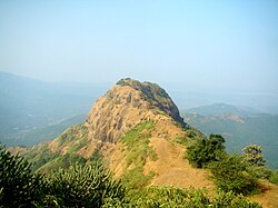
[[File:JJayagad Fort.jpg|thumb|Fort]] | [[File:JJayagad Fort.jpg|thumb|Fort]] | ||
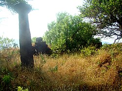
[[File:JJayagad Fort1.jpg|thumb|Devi temple]] | [[File:JJayagad Fort1.jpg|thumb|Devi temple]] | ||
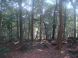
[[File:JJayagad Fort2.jpg|thumb|Jungle]] | [[File:JJayagad Fort2.jpg|thumb|Jungle]] | ||
==Places of interest== | ==Places of interest== | ||
| Line 29: | Line 29: | ||
==How to reach== | ==How to reach== | ||
Nearest town is Koyananagar which is {{convert|43|km|abbr=on}} from [[Chiplun]]. There are good hotels and resorts in [[Koynanagar|Koyananagar]]. The entry permission to the fort is to be obtained from the forest office at Koyananagar. The village Nawja is located at 11 km from Koyananagar. There are authorised forest local guides staying in Nawja, whose participation in the trek is compulsory. The road from Nawja to the tunnel is to be followed for more 3 km. The vehicles are to be kept on the road and further a trekking of 1 hr leads to the fort. There are [[leech]]es and [[ticks]] in the forest during humid weather condition.<ref name="Trekshitiz">{{cite web |last1=Trekshitiz |title=Jangali Jaigad |url=http://trekshitiz.com/trekshitiz/Ei/Jangli_Jaigad-Trek-Satara-District.html |publisher=Trekshitiz |access-date=21 December 2019}}</ref> | Nearest town is Koyananagar which is {{convert|43|km|abbr=on}} from [[Chiplun]]. There are good hotels and resorts in [[Koynanagar|Koyananagar]]. The entry permission to the fort is to be obtained from the forest office at Koyananagar. The village Nawja is located at 11 km from Koyananagar. There are authorised forest local guides staying in Nawja, whose participation in the trek is compulsory. The road from Nawja to the tunnel is to be followed for more 3 km. The vehicles are to be kept on the road and further a trekking of 1 hr leads to the fort. There are [[leech]]es and [[ticks]] in the forest during humid weather condition.<ref name="Trekshitiz">{{cite web |last1=Trekshitiz |title=Jangali Jaigad |url=http://trekshitiz.com/trekshitiz/Ei/Jangli_Jaigad-Trek-Satara-District.html |publisher=Trekshitiz |access-date=21 December 2019 |archive-date=21 December 2019 |archive-url=https://web.archive.org/web/20191221092335/http://trekshitiz.com/trekshitiz/Ei/Jangli_Jaigad-Trek-Satara-District.html |url-status=dead }}</ref> | ||
==See also== | ==See also== | ||
Latest revision as of 02:13, 30 September 2025
| Jangali Jayagad | |
|---|---|
Jangali Jayagad is located in Maharashtra  Jangali Jayagad Location of Jangali Jayagad, Maharashtra | |
| Highest point | |
| Elevation | 965 m (3,166 ft) |
| Coordinates | 17°27′12.8″N 73°41′37.6″E / 17.453556°N 73.693778°E |
| Geography | |
| Location | Maharashtra, India |
| Parent range | Western Ghats |
| Climbing | |
| Easiest route | Hike |
Jangali Jayagad is located in Patan taluka of Satara District. This fort is situated on a hilly spur from the main ridge of Sahyadri. This fort is less visited due to its occurrence in Koyana Wildlife sanctuary. The nearby village is Nawja. The trek to the fort can easily be completed in a day.


Places of interest[edit | edit source]
The fort is in a very dilapidated condition. There is no main entrance gate, water cistern or caves on the fort. There is an old well and ruins of Devi temple. The path to the fort passes through dense forest. The scats, droppings, hoof marks and pugmarks of various wild animals can be seen. The path is regularly used by wild Gaur( Bison). The dwindling ghat road to Chiplun can be seen from the fort. The jungle is home to variety of Insects, Birds, reptiles and animals.
How to reach[edit | edit source]
Nearest town is Koyananagar which is 43 km (27 mi) from Chiplun. There are good hotels and resorts in Koyananagar. The entry permission to the fort is to be obtained from the forest office at Koyananagar. The village Nawja is located at 11 km from Koyananagar. There are authorised forest local guides staying in Nawja, whose participation in the trek is compulsory. The road from Nawja to the tunnel is to be followed for more 3 km. The vehicles are to be kept on the road and further a trekking of 1 hr leads to the fort. There are leeches and ticks in the forest during humid weather condition.[1]
See also[edit | edit source]
References[edit | edit source]
- ↑ Trekshitiz. "Jangali Jaigad". Trekshitiz. Archived from the original on 21 December 2019. Retrieved 21 December 2019.


Satara district topics | ||
|---|---|---|
| History |  | |
| Battles | ||
| Rivers | ||
| Dams | ||
| Lakes | ||
| Ghats | ||
| Caves | ||
| Cities and towns | ||
| Villages | ||
| Places to see | ||
| Monuments | ||
| Transport | ||
| Education | ||
| Lok Sabha constituencies | ||
| Vidhan Sabha constituencies | ||
| Culture | ||