



imported>Firestar464 Reverting edit(s) by 2409:4053:2208:B7A9:A1FE:51CE:8E51:4937 (talk) to rev. 1023772447 by 2402:8100:2150:E173:EEDC:4D12:88FB:92AD: Unexplained content removal (RW 16.1) |
WikiDwarfBOT (talk | contribs) Cleanup: |
||
| Line 1: | Line 1: | ||
{{ | {{Distinguish|text = [[Srinagar]], the summer capital of Jammu and Kashmir}} | ||
{{Use dmy dates|date=August 2015}} | {{Use dmy dates|date=August 2015}} | ||
{{Use Indian English|date=August 2015}} | {{Use Indian English|date=August 2015}} | ||
<!-- See [[Wikipedia:WikiProject Indian cities]] for details -->{{Infobox settlement | <!-- See [[Wikipedia:WikiProject Indian cities]] for details -->{{Infobox settlement | ||
| name | | name = Srinagar | ||
| other_name | | other_name = | ||
| nickname | | nickname = | ||
| settlement_type | | settlement_type = [[City]] | ||
| image_skyline | | image_skyline = Srinagar Garhwal with Chauras view.jpg | ||
| image_alt | | image_alt = | ||
| image_caption | | image_caption = View of Srinagar, [[Pauri Garhwal]], [[Uttarakhand]] with mountains | ||
| pushpin_map | | pushpin_map = India Uttarakhand#India | ||
| pushpin_map_alt | | pushpin_map_alt = | ||
| pushpin_map_caption | | pushpin_map_caption = Location in Uttarakhand, India | ||
| coordinates | | coordinates = {{coord|30.22|N|78.78|E|display=inline,title}} | ||
| subdivision_type | | subdivision_type = Country | ||
| subdivision_name | | subdivision_name = {{flagicon|IND}} [[India]] | ||
| subdivision_type1 | | subdivision_type1 = [[States and territories of India|State]] | ||
| subdivision_name1 | | subdivision_name1 = [[Uttarakhand]] | ||
| subdivision_type2 | | subdivision_type2 = [[List of districts of India|District]] | ||
| subdivision_name2 | | subdivision_name2 = [[Pauri Garhwal district|Pauri Garhwal]] | ||
| established_title | | established_title = <!-- Established --> | ||
| established_date | | established_date = | ||
| founder | | founder = | ||
| named_for | | named_for = | ||
| government_type | | government_type = | ||
| governing_body | | governing_body = | ||
| unit_pref | | unit_pref = Metric | ||
| area_footnotes | | area_footnotes = | ||
| area_rank | | area_rank = | ||
| area_total_km2 | | area_total_km2 = 1257 | ||
| elevation_footnotes | | elevation_footnotes = | ||
| elevation_m | | elevation_m = 560 | ||
| population_total | | population_total = 37911 | ||
| population_as_of | | population_as_of = 2011 | ||
| population_rank | | population_rank = | ||
| population_density_km2 | | population_density_km2 = 30.16 | ||
| population_demonym | | population_demonym = | ||
| population_footnotes | | population_footnotes = | ||
| demographics_type1 | | demographics_type1 = Languages | ||
| demographics1_title1 | | demographics1_title1 = Official | ||
| demographics1_info1 | | demographics1_info1 = [[Hindi]], [[Sanskrit]], [[Garhwali language|Garhwali]]([[Srinagaria]]) | ||
| timezone1 | | timezone1 = [[Indian Standard Time|IST]] | ||
| utc_offset1 | | utc_offset1 = +5:30 | ||
| postal_code_type | | postal_code_type = [[Postal Index Number|PIN]] | ||
| postal_code | | postal_code = 246174 | ||
| area_code_type | | area_code_type = Telephone code | ||
| area_code | | area_code = 01346-2 | ||
| registration_plate | | registration_plate = UK 12 xx xxxx | ||
| website | | website = {{URL|pauri.nic.in}} | ||
| footnotes | | footnotes = | ||
}} | }} | ||
'''Srinagar''' is a city in [[Pauri Garhwal district]] in the [[India]]n [[States and territories of India|state]] of [[Uttarakhand]]. | '''Srinagar''' is a [[city]] and [[Municipal corporations of India|municipal corporation]] in [[Pauri Garhwal district]] in the [[India]]n [[States and territories of India|state]] of [[Uttarakhand]]. It is located about 33 km from [[Pauri|Pauri town]], the administrative headquarters of [[Pauri Garhwal district]], [[Uttarakhand|Uttarakhand, India]]. | ||
==Geography== | ==Geography== | ||
Srinagar is located at {{Coord|30.22|N|78.78|E|}}.<ref>[http://www.fallingrain.com/world/IN/39/Srinagar.html Falling Rain Genomics, Inc – Srinagar]</ref> at the left bank of [[Alaknanda]] river. It has an average elevation of 560 [[metre]]s (1,837 [[foot (length)|feet]]). It is the largest town in the [[Garhwal Himalaya|Garhwal Hills]]. It is reached by national highway [[National Highway 58 (India)|NH58]] from [[Rishikesh]], Srinagar is about | Srinagar is located at {{Coord|30.22|N|78.78|E|}}.<ref>[http://www.fallingrain.com/world/IN/39/Srinagar.html Falling Rain Genomics, Inc – Srinagar]</ref> at the left bank of [[Alaknanda]] river. It has an average elevation of 560 [[metre]]s (1,837 [[foot (length)|feet]]). It is the largest town in the [[Garhwal Himalaya|Garhwal Hills]]. It is reached by national highway [[National Highway 58 (India)|NH58]] from [[Rishikesh]], Srinagar is about 104 km from [[Rishikesh]] which is the last city on the plains of [[Uttarakhand]] and from where the mountains start. Srinagar can also be reached via [[Kotdwara]], from [[Kotdwara]] it takes maximum 5 hours to reach there.It is a municipal board in the Pauri district of uttarakhand which is now upgraded to Municipal Corporation recently.[[File:Srinagar from southern hill.jpg|thumb|Srinagar from southern hill]] | ||
[[File:Srinagar from southern hill.jpg|thumb|Srinagar from southern hill]] | |||
==Demographics== | ==Demographics== | ||
| Line 76: | Line 75: | ||
==Climate== | ==Climate== | ||
Srinagar | Srinagar's location in a [[valley]] flanked by high mountains means the city sees large annual temperature variations. Daytime high temperatures can exceed {{Convert|44|°C}} between May and July, and the city sees the hottest summers of anywhere in the [[Garhwal Himalaya]]. On the coldest days of the year, which come mostly in December and January, the daytime high temperature sometimes does not exceed {{Convert|2|°C}}.{{Citation needed|date=November 2022}} | ||
==Education== | ==Education== | ||
| Line 83: | Line 82: | ||
[[National Institute of Technology, Uttarakhand]] opened in 2010. | [[National Institute of Technology, Uttarakhand]] opened in 2010. | ||
Srinagar Base Hospital Medical college with MBBS and MS courses having more than 500 students, is also situated at Srikot about 5 km from Srinagar towards [[Jyotirmath|Joshimath]].<ref>[http://www.ua.nic.in/smc.ac.in/ "Srinagar Medical College"], | Srinagar Base Hospital Medical college with MBBS and MS courses having more than 500 students, is also situated at Srikot about 5 km from Srinagar towards [[Jyotirmath|Joshimath]].<ref>[http://www.ua.nic.in/smc.ac.in/ "Srinagar Medical College"], Uttarakhand Government Medical College Srinagar (Pauri Garhwal)</ref> | ||
One ITI and one Polytechnic along with one B.Ed college are other educational institutes in Srinagar. | One ITI and one Polytechnic along with one B.Ed. college are other educational institutes in Srinagar. | ||
[[Sashastra Seema Bal]] (SSB) Cadets Training Academy is also operating here for long. | |||
[[Sashastra Seema Bal]] (SSB) Cadets Training Academy is also operating here for long.It is now functioning as Centralised Training Center or CTC. | |||
St. Theresa's School which is an English medium school situated near Alaknanda river. The School has been recognized by Council for Indian School Certificate Examinations since a long time. | St. Theresa's School which is an English medium school situated near Alaknanda river. The School has been recognized by Council for Indian School Certificate Examinations since a long time. | ||
| Line 98: | Line 98: | ||
The literacy rate of Srinagar city is 92.03% higher than the state average of 78.82%. In Srinagar, Male literacy is around 94.22% while the female literacy rate is 89.51% | The literacy rate of Srinagar city is 92.03% higher than the state average of 78.82%. In Srinagar, Male literacy is around 94.22% while the female literacy rate is 89.51% | ||
== | ==Transportation== | ||
===Railways=== | |||
Till date '''Sri-Gadwall''' has nearest railway stations either at '''Kotdwara''' or at '''Rishikesh'''. But A Centre-State train project is undergone to link [[Char Dham]] of Gadwall. After finishing of project Sri Gadwall will have three consequent railway stations. | |||
*'''Sri-Kedar''': | |||
or Maletha-Janasu Railway station. | |||
*'''Sri-Nagar''': | |||
or Naithana-Chauras Railway station. | |||
*'''Srikot''': | |||
or Sueet-Dhari Railway Station. | |||
=== | ===Airways=== | ||
[[File:Kot Village Droneview Proposed for Sri Gadwall Airport.jpg|thumb|Proposed Sri Gadwall Airport]] | |||
{{Location map+|India Uttarakhand|width=800|float=center|caption=Main Cities of Gadwall|places= | |||
{{Location map~|India Uttarakhand|lat_deg=30.2247|lat_dir=N|lon_deg=78.7986|lon_dir=E|position=top|background=#FFFFFF|label=Sri Gadwall}} | |||
{{Location map~|India Uttarakhand|lat_deg=30.1494|lat_dir=N|lon_deg=78.6963|lon_dir=E|position=top|background=#FFFFFF|label=[[Kot, Uttarakhand|Sri Port]]}} | |||
}} | |||
An Airport is proposed by '''Gadwall Apadraj Dal''' at [[Kot, Uttarakhand]]. Kot is suitable for '''[[Sri Gadwall Airport]]'''. It is demanded to enhance Char dham Tourism. Although current regime of BJP is not interested in it, but Gadwall Apadraj Dal is constantly supporting this project.It also provisioned to have a multi-lane fast track roadway and railway line from Srinagar to Kot for the ease to reach Airport. | |||
== | ==Politics== | ||
Srinagar is | ===Governing Body=== | ||
Srinagar is administered through a [[municipal corporation]] [[Municipal Corporation Srinagar|Sri Gadwall]]. | |||
It is the 9th municipal corporation in Uttarakhand, 1st in hill region of Uttarakhand, 1st in Garhwal and Kumaon, and 1st in Pauri Garhwal district. | |||
==Tourism== | |||
===Religious Tourism=== | |||
{| class="wikitable" | |||
|+ Caption text | |||
|- | |||
! Name !! Type !! Image | |||
|- | |||
| Kamleshwar || Temple || | |||
|- | |||
| Kilkileshwar || Temple || | |||
|- | |||
| Ashtvakra || Temple || | |||
|- | |||
| Ghasiya Mahadev || Temple || | |||
|- | |||
| Shani Mandir || Temple || | |||
|- | |||
|} | |||
==References== | ==References== | ||
| Line 141: | Line 149: | ||
==External links== | ==External links== | ||
* [http://www.srinagargarhwal.com/ Srinagar Garhwal, Uttarakhand Himalayas] | * [http://www.srinagargarhwal.com/ Srinagar Garhwal, Uttarakhand Himalayas] | ||
* [http://www.uttara.in/hindi/apexinstitutes/hnbgu/campuses/srinagar.html Srinagar campus of HNBGU] | * [http://www.uttara.in/hindi/apexinstitutes/hnbgu/campuses/srinagar.html Srinagar campus of HNBGU] | ||
Latest revision as of 07:34, 22 July 2023
Srinagar | |
|---|---|
 View of Srinagar, Pauri Garhwal, Uttarakhand with mountains | |
  Srinagar Location in Uttarakhand, India  Srinagar Srinagar (India) | |
| Coordinates: 30°13′N 78°47′E / 30.22°N 78.78°E | |
| Country |  India India |
| State | Uttarakhand |
| District | Pauri Garhwal |
| Area | |
| • Total | 1,257 km2 (485 sq mi) |
| Elevation | 560 m (1,840 ft) |
| Population (2011) | |
| • Total | 37,911 |
| • Density | 30.16/km2 (78.1/sq mi) |
| Languages | |
| • Official | Hindi, Sanskrit, Garhwali(Srinagaria) |
| Time zone | UTC+5:30 (IST) |
| PIN | 246174 |
| Telephone code | 01346-2 |
| Vehicle registration | UK 12 xx xxxx |
| Website | pauri |
Srinagar is a city and municipal corporation in Pauri Garhwal district in the Indian state of Uttarakhand. It is located about 33 km from Pauri town, the administrative headquarters of Pauri Garhwal district, Uttarakhand, India.
Geography[edit | edit source]
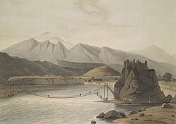
Srinagar is located at 30°13′N 78°47′E / 30.22°N 78.78°E.[1] at the left bank of Alaknanda river. It has an average elevation of 560 metres (1,837 feet). It is the largest town in the Garhwal Hills. It is reached by national highway NH58 from Rishikesh, Srinagar is about 104 km from Rishikesh which is the last city on the plains of Uttarakhand and from where the mountains start. Srinagar can also be reached via Kotdwara, from Kotdwara it takes maximum 5 hours to reach there.It is a municipal board in the Pauri district of uttarakhand which is now upgraded to Municipal Corporation recently.

Demographics[edit | edit source]
As per the 2011 census, Srinagar had a population of 20,115. Males constituted 52% of the population and females 48%. Srinagar is the largest city in the Garhwal hills.
Geology[edit | edit source]
Srinagar city mainly rests over the Quaternary fluvial terraces of boulders and sand deposited by Alaknanda river. The hard rock under these boulder-sand terraces is the Proterozoic phyllite called Pauri Phyllite. This highly fractured Pauri Phyllite of Chandpur Formation (Jaunsar Group) is separated from the quartzite and limestone of Rudraprayag Formation by the North Almora Thrust (NAT), sometimes also called Srinagar Thrust.

History[edit | edit source]

Srinagar came into limelight after becoming the capital of Garhwal Kingdom. King Ajay Pal with unifying the various chiefdoms and garhis[what language is this?] (small counties) of this region during 1506–1512 CE founded the Garhwal kingdom and shifted the capital to Srinagar place from Chandpur Garhi.
The Gorkhas defeated the Nepali king and occupied Kathmandu. This emboldened them and they turned westward and attacked Kumaon and Garhwal in 1803. Raja Pradyumna Shah of Garhwal was defeated and killed in January 1804. Srinagar was under Gorkha rule from 1806 to 1815 CE. After the Gorkhas were defeated by the British, Srinagar became a part of British Garhwal.[2]
The old Srinagar city was destroyed in the Gohna Lake dam-burst which destroyed all the old relics of the town.
Today the town is an important cultural and educational centre. Being placed in central Garhwal at a moderate height, it is an important Valley Bazar in the hills. It has a number of temples and monuments and places for tourists to stay and visit.
Climate[edit | edit source]
Srinagar's location in a valley flanked by high mountains means the city sees large annual temperature variations. Daytime high temperatures can exceed 44 °C (111 °F) between May and July, and the city sees the hottest summers of anywhere in the Garhwal Himalaya. On the coldest days of the year, which come mostly in December and January, the daytime high temperature sometimes does not exceed 2 °C (36 °F).[citation needed]
Education[edit | edit source]
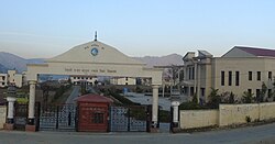
Hemwati Nandan Bahuguna Garhwal University (renamed after Hemvati Nandan Bahuguna in 1989), established in 1973, is situated at Srinagar. The University has jurisdiction over seven districts of the Garhwal region. It was made a Central University in 2009 by the Central Universities Act, 2009. It has two other teaching campuses at Pauri and Tehri towns. It is a residential cum affiliating institution of higher learning with more than 180 affiliated colleges.
National Institute of Technology, Uttarakhand opened in 2010.
Srinagar Base Hospital Medical college with MBBS and MS courses having more than 500 students, is also situated at Srikot about 5 km from Srinagar towards Joshimath.[3]
One ITI and one Polytechnic along with one B.Ed. college are other educational institutes in Srinagar.
Sashastra Seema Bal (SSB) Cadets Training Academy is also operating here for long.It is now functioning as Centralised Training Center or CTC.
St. Theresa's School which is an English medium school situated near Alaknanda river. The School has been recognized by Council for Indian School Certificate Examinations since a long time.
Sri Guru Ram Rai(SGRR) is another popular school in Srinagar which located near Kamleshwar Mahadev Mandir. The School has been recognized by Central Board of Secondary Education.
There are many schools affiliated to CBSE, CISCE and UBSE Boards in the town which provide a versatile education system for all-round development.

The literacy rate of Srinagar city is 92.03% higher than the state average of 78.82%. In Srinagar, Male literacy is around 94.22% while the female literacy rate is 89.51%
Transportation[edit | edit source]
Railways[edit | edit source]
Till date Sri-Gadwall has nearest railway stations either at Kotdwara or at Rishikesh. But A Centre-State train project is undergone to link Char Dham of Gadwall. After finishing of project Sri Gadwall will have three consequent railway stations.
- Sri-Kedar:
or Maletha-Janasu Railway station.
- Sri-Nagar:
or Naithana-Chauras Railway station.
- Srikot:
or Sueet-Dhari Railway Station.
Airways[edit | edit source]


An Airport is proposed by Gadwall Apadraj Dal at Kot, Uttarakhand. Kot is suitable for Sri Gadwall Airport. It is demanded to enhance Char dham Tourism. Although current regime of BJP is not interested in it, but Gadwall Apadraj Dal is constantly supporting this project.It also provisioned to have a multi-lane fast track roadway and railway line from Srinagar to Kot for the ease to reach Airport.
Politics[edit | edit source]
Governing Body[edit | edit source]
Srinagar is administered through a municipal corporation Sri Gadwall.
It is the 9th municipal corporation in Uttarakhand, 1st in hill region of Uttarakhand, 1st in Garhwal and Kumaon, and 1st in Pauri Garhwal district.
Tourism[edit | edit source]
Religious Tourism[edit | edit source]
| Name | Type | Image |
|---|---|---|
| Kamleshwar | Temple | |
| Kilkileshwar | Temple | |
| Ashtvakra | Temple | |
| Ghasiya Mahadev | Temple | |
| Shani Mandir | Temple |
References[edit | edit source]
- ↑ Falling Rain Genomics, Inc – Srinagar
- ↑ [Negi, S. S. 2003. Srinagar- A Historical township, In Sovenier of 20th Convention of Indian Association of Sedimentologist, pp- 29 Srinagar Garhwal]
- ↑ "Srinagar Medical College", Uttarakhand Government Medical College Srinagar (Pauri Garhwal)
External links[edit | edit source]
State of Uttarakhand | |||||||||||||||||
|---|---|---|---|---|---|---|---|---|---|---|---|---|---|---|---|---|---|
| Government |  | ||||||||||||||||
| History |
| ||||||||||||||||
| Geography and Ecology |
| ||||||||||||||||
| Demographics |
| ||||||||||||||||
| Administrative divisions |
| ||||||||||||||||
| Politics | |||||||||||||||||
| Tourism |
| ||||||||||||||||
| Sports | |||||||||||||||||
| Other topics | |||||||||||||||||
| Districts |
| ||||||||||||||||
| Major cities | |||||||||||||||||