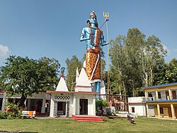
Khatima
Khatima | |
|---|---|
Town | |
 Vankhandi Mahadev near Chakarpur, Khatima | |
| Coordinates: 28°55′N 79°58′E / 28.92°N 79.97°ECoordinates: 28°55′N 79°58′E / 28.92°N 79.97°E | |
| Country | |
| State | Uttarakhand |
| District | Udham Singh Nagar |
| Area | |
| • Total | 25 km2 (10 sq mi) |
| Population (2011)[1] | |
| • Total | 15,093 |
| • Density | 600/km2 (1,600/sq mi) |
| Languages | |
| • Official | Hindi,[2] Kumaoni |
| Time zone | UTC+5:30 (IST) |
| PIN | 262308 |
| Telephone code | 05943 |
| Vehicle registration | UK 06 |
| Website | uk |
Khatima is a town and a municipal board in Udham Singh Nagar district in the Indian state of Uttarakhand.[1]
Khatima is located at 28°55′N 79°58′E / 28.92°N 79.97°E.[3] It has an average elevation of 299 metres (980 feet).
Demographics[edit | edit source]
As of 2011 Indian Census, Khatima had a total population of 15,093, of which 8,024 were males and 7,069 were females. The population within the age group of 0 to 6 years was 1,864. The total number of literates in Khatima was 11,003, which constituted 72.9% of the population with male literacy of 77.8% and female literacy of 67.3%. The effective literacy rate of the 7+ population of Khatima was 83.2%, of which the male literacy rate was 88.8% and the female literacy rate was 76.7%. The Scheduled Castes and Scheduled Tribes population was 1,735 and 379 respectively. Khatima had 2912 households in 2011.[1]
The 2001 Indian census recorded the population of Khatima as 14,378, with males constituting 54% of the population and females 46%. The literacy rate was 66%, of which male literacy was 73%, and female literacy was 58%. 16% of the population was under 6 years of age.[4]
Notable People[edit | edit source]
- Pushkar Singh Dhami, 10th Chief Minister of Uttarakhand.
- Bhuwan Chandra Kapri, Member of the 5th Uttarakhand Assembly.
References[edit | edit source]
- ↑ 1.0 1.1 1.2 "Census of India: Khatima". www.censusindia.gov.in. Retrieved 12 January 2020.
- ↑ "52nd Report of the Commissioner for Linguistic Minorities in India" (PDF). nclm.nic.in. Ministry of Minority Affairs. p. 18. Archived from the original (PDF) on 25 May 2017. Retrieved 27 May 2019.
- ↑ Falling Rain Genomics, Inc - Khatima
- ↑ "Census of India 2001: Data from the 2001 Census, including cities, villages and towns (Provisional)". Census Commission of India. Archived from the original on 16 June 2004. Retrieved 1 November 2008.
