

>Johnbod removed Category:Indus Valley Civilisation using HotCat - in sub-cat |
m robot: Update article (please report if you notice any mistake or error in this edit) |
||
| Line 43: | Line 43: | ||
The basin is classified in two parts, [[Khadir and Bangar]], the higher area that is not flooded in rainy season is called ''Bangar'' and the lower flood-prone area is called ''Khadar''.<ref name="Har1">[http://www.haryana-online.com/geography.htm HaryanaOnline - Geography of Haryana] {{webarchive|url=https://web.archive.org/web/20160201121800/http://www.haryana-online.com/geography.htm |date= 1 February 2016 }}</ref> | The basin is classified in two parts, [[Khadir and Bangar]], the higher area that is not flooded in rainy season is called ''Bangar'' and the lower flood-prone area is called ''Khadar''.<ref name="Har1">[http://www.haryana-online.com/geography.htm HaryanaOnline - Geography of Haryana] {{webarchive|url=https://web.archive.org/web/20160201121800/http://www.haryana-online.com/geography.htm |date= 1 February 2016 }}</ref> | ||
Several archaeologists have identified the old [[Ghaggar-Hakra River]] with the [[Sarasvati river]], on the banks of which the [[Indus Valley | Several archaeologists have identified the old [[Ghaggar-Hakra River]] with the [[Sarasvati river]], on the banks of which the [[Indus Valley civilisation]] developed.<ref name="Possehl 1997">{{citation |first=Gregory L. |last=Possehl |authorlink=Gregory Possehl |title=The Transformation of the Indus Civilization |journal=Journal of World Prehistory |volume=11 |number=4 |date=December 1997 |pages=425–472 |jstor=25801118 |doi=10.1007/bf02220556|s2cid=161129625 }}</ref><ref name="Kenoyer 1997">{{citation |last=Kenoyer |first=J. M. |year=1997 |chapter=Early City-states in South Asia: Comparing the Harappan Phase and the Early Historic Period |title=The Archaeology of City States: Cross Cultural Approaches |editor1=D. L. Nichols |editor2=T. H. Charlton |pages=52–70 |location=Washington |publisher=Smithsonian Institution Press|isbn=1560987227 |url=https://books.google.com/books?id=iORzQgAACAAJ}}</ref><ref>{{citation|last1=Allchin|first1=Bridget|last2=Allchin|first2=Raymond|title=The Rise of Civilization in India and Pakistan|url=https://books.google.com/books?id=r4s-YsP6vcIC|year=1982|publisher=Cambridge University Press|isbn=978-0-521-28550-6 |page=160}}</ref>{{sfn|Erdosy|1995|p=44, 266}} | ||
== Gallery == | == Gallery == | ||
<gallery> | <gallery> | ||
IVC-major-sites-2.jpg|[[Indus Valley | IVC-major-sites-2.jpg|[[Indus Valley civilisation|Indus–Sarasvati civilisation]] major sites | ||
Ghaggar river in Panchkula.jpg|[[Ghaggar-Hakra River|Ghaggar river]] flowing through [[Panchkula]] in [[Haryana]] | Ghaggar river in Panchkula.jpg|[[Ghaggar-Hakra River|Ghaggar river]] flowing through [[Panchkula]] in [[Haryana]] | ||
Flock of Cormorants, Kaushalaya dam, Haryana, India.JPG|Flock of Cormorants at [[Kaushalya Dam]] | Flock of Cormorants, Kaushalaya dam, Haryana, India.JPG|Flock of Cormorants at [[Kaushalya Dam]] | ||
| Line 75: | Line 75: | ||
{{commons category|Ghaggar-Hakra river}} | {{commons category|Ghaggar-Hakra river}} | ||
{{commons category|Sarasvati River}} | {{commons category|Sarasvati River}} | ||
{{Hydrography of Haryana}} | {{Hydrography of Haryana}} | ||
Revision as of 04:52, 26 June 2022
| Kaushalya River | |
|---|---|
 Kaushalya dam near Pinjore | |
| Location | |
| Country | India |
| Physical characteristics | |
| Source | |
| • location | Shivalik Hills, Himachal Pradesh |
| Mouth | |
• location | Panchkula district, Haryana |
| Length | 20 km (12 mi) |
| Discharge | |
| • location | Ghaggar river just south-east of Pinjore |
| Basin features | |
| Waterbodies | Kaushalya Dam |
| Bridges | Kaushalya bridge |
The Kaushalya river, a tributary of Ghaggar river, is a river in Panchkula district of Haryana state of India.[1]
Origin and route
The Kaushalya river rises in the Shivalik hills on the border of Haryana and Himachal Pradesh State, and flows through Panchkula district and confluences with Ghaggar river near Pinjore just downstream of Kaushalya Dam.[1]
The basin is classified in two parts, Khadir and Bangar, the higher area that is not flooded in rainy season is called Bangar and the lower flood-prone area is called Khadar.[2]
Several archaeologists have identified the old Ghaggar-Hakra River with the Sarasvati river, on the banks of which the Indus Valley civilisation developed.[3][4][5][6]
Gallery
-
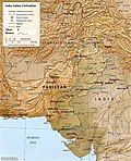 Indus–Sarasvati civilisation major sites
 -

-
 Flock of Cormorants at Kaushalya Dam
 -

-

-
 Migratory birds at Kaushalya Dam (Dec. 2015)
 -
 Water of Kaushalya Dam attracts local and migratory birds (June 2015)


See also
- Western Yamuna Canal, branches off Yamuna
- Dangri, a tributary of Sarsuti
- Tangri river, a tributary of Sarsuti, merge if Dangri and Tangri are same
- Markanda river, a tributary of Ghaggar-Hakra River
- Sarsuti, a tributary of Ghaggar-Hakra River
- Chautang, a tributary of Ghaggar-Hakra River
- Sutlej, a tributary of Indus
- Ganges
- Indus
References
- ↑ 1.0 1.1 Hillsofmorni.com - Kaushalya dam
- ↑ HaryanaOnline - Geography of Haryana Archived 1 February 2016 at the Wayback Machine
- ↑ Possehl, Gregory L. (December 1997), "The Transformation of the Indus Civilization", Journal of World Prehistory, 11 (4): 425–472, doi:10.1007/bf02220556, JSTOR 25801118, S2CID 161129625
- ↑ Kenoyer, J. M. (1997), "Early City-states in South Asia: Comparing the Harappan Phase and the Early Historic Period", in D. L. Nichols; T. H. Charlton (eds.), The Archaeology of City States: Cross Cultural Approaches, Washington: Smithsonian Institution Press, pp. 52–70, ISBN 1560987227
- ↑ Allchin, Bridget; Allchin, Raymond (1982), The Rise of Civilization in India and Pakistan, Cambridge University Press, p. 160, ISBN 978-0-521-28550-6
- ↑ Erdosy 1995, p. 44, 266.
External links
| Rivers | |
|---|---|
| Lakes |
|
| Dams, Barrages | |

.png)


