
>Citation bot Add: title. Changed bare reference to CS1/2. | Use this bot. Report bugs. | Suggested by BrownHairedGirl | Linked from User:BrownHairedGirl/Articles_with_bare_links | #UCB_webform_linked 829/2198 |
->Bhawani55 Faridkot District |
||
| Line 61: | Line 61: | ||
}} | }} | ||
'''Faridkot district''' is one of the 22 districts in the state of [[Punjab (India)|Punjab]], [[India]] with Faridkot city as | '''Faridkot district''' is one of the 22 districts in the state of [[Punjab (India)|Punjab]], [[India]] with Faridkot city as the district headquarters. | ||
== Etymology == | == Etymology == | ||
| Line 67: | Line 67: | ||
== History == | == History == | ||
{{historical populations|21=1951|22=182145|23=1961|24=244718|25=1971|26=293475|27=1981|28=370556|29=1991|30=455005|31=2001|32=550892|33=2011|34=617508|percentages=pagr|footnote=source:<ref>[http://www.censusindia.gov.in/2011census/PCA/A2_Data_Table.html Decadal Variation In Population Since 1901]</ref>|align=right}}Prior to independence, a large part of the district was under the rule of the Maharaja of Faridkot and later it became a part of the [[Patiala & East Punjab States Union]] (PEPSU ) in 1948. Faridkot was carved out as a separate district on 7 August 1972 out of the areas of erstwhile Bathinda District(Faridkot Tehsil) and Ferozepur District(Moga and Muktsar Tehsils). Further, in November 1995 the Faridkot District was trifurcated when two of its subdivisions viz. [[Muktsar]] and [[Moga, Punjab|Moga]] were given the status of independent districts. | {{historical populations|21=1951|22=182145|23=1961|24=244718|25=1971|26=293475|27=1981|28=370556|29=1991|30=455005|31=2001|32=550892|33=2011|34=617508|percentages=pagr|footnote=source:<ref>[http://www.censusindia.gov.in/2011census/PCA/A2_Data_Table.html Decadal Variation In Population Since 1901]</ref>|align=right}}Prior to independence, a large part of the district was under the rule of the Maharaja of Faridkot and later it became a part of the [[Patiala & East Punjab States Union]] (PEPSU ) in 1948. Before independence the Muslim population was 35% mainly from [[Jat]], [[Mochi]], [[Arain]] and [[Tarkhan]] castes who migrated to Pakistan and settled mainly in [[Okara District|Okara]], [[Kasur]], [[Pakpattan]] and [[Bahawalnagar]] Districts. Faridkot was carved out as a separate district on 7 August 1972 out of the areas of erstwhile Bathinda District(Faridkot Tehsil) and Ferozepur District(Moga and Muktsar Tehsils). Further, in November 1995 the Faridkot District was trifurcated when two of its subdivisions viz. [[Muktsar]] and [[Moga, Punjab|Moga]] were given the status of independent districts. | ||
==Government body== | ==Government body== | ||
Prior to independence large part of the district was under the princely rule of Sikh Maharaja of Faridkot and later it became part of the Patiala & East Punjab States Union (PEPSU ) in 1948. Faridkot was carved out as a separate district on 7 August 1972 out of the areas of Bathinda District (Faridkot Tehsil) and Ferozepur District (Moga and Muktsar Tehsils). However, in November 1995, the Faridkot District was trifurcated when two of its subdivisions viz Muktsar and Moga were given the status of independent districts. | Prior to independence large part of the district was under the princely rule of Sikh Maharaja of Faridkot and later it became part of the Patiala & East Punjab States Union (PEPSU ) in 1948. Faridkot was carved out as a separate district on 7 August 1972 out of the areas of Bathinda District (Faridkot Tehsil) and Ferozepur District (Moga and Muktsar Tehsils). However, in November 1995, the Faridkot District was trifurcated when two of its subdivisions viz Muktsar and Moga were given the status of independent districts. | ||
Faridkot district is surrounded by district Ferozepur in the North-West, Muktsar in the South-West, Bathinda in the South, and Moga in the West. The District covers an area of 1469 km<sup>2</sup>. which is 2.92% of the total area of the State and accommodates a population of 552,466, which is 2.27% of the total population of the State. It has three Subdivisions/ Tehsils namely Faridkot, Kotkapura and Jaito and a Sub Tehsil namely Sadiq comprising a total of 171 villages. Faridkot District has two development blocks namely [[Faridkot, Punjab|Faridkot]] and [[Kotkapura]]. | Faridkot district is surrounded by district [[Firozpur|Ferozepur]] in the North-West, [[Muktsar district|Muktsar]] in the South-West, Bathinda in the South, and Moga in the West. The District covers an area of 1469 km<sup>2</sup>. which is 2.92% of the total area of the State and accommodates a population of 552,466, which is 2.27% of the total population of the State. It has three Subdivisions/ Tehsils namely Faridkot, Kotkapura and Jaito and a Sub Tehsil namely Sadiq comprising a total of 171 villages. Faridkot District has two development blocks namely [[Faridkot, Punjab|Faridkot]] and [[Kotkapura]]. | ||
In 2020, Faridkot has been made new police division. Earlier, Faridkot was part of Ferozepur police division. Moga and Mukatsar districts were also attached with Faridkot police division. | In 2020, Faridkot has been made new police division. Earlier, Faridkot was part of Ferozepur police division. Moga and Mukatsar districts were also attached with Faridkot police division. | ||
==Overview== | ==Overview== | ||
The Faridkot district contains 2 Cities [[Faridkot, Punjab|Faridkot]], [[Kotkapura]]. More than 7 towns/villages are quite notable in the Faridkot area such as Jaitu, Bajakhana, Panjgarain Kalan, Deep Singh Wala, Golewala, [[Jhok Sarkari]], Doad, Ghugiana, Sadiq, Chand Bhan, etc. Faridkot is a hub for premier educational institutions. North India's only Medical University, also named after Baba Farid is in Faridkot besides Medical | The Faridkot district contains 2 Cities [[Faridkot, Punjab|Faridkot]], [[Kotkapura]]. More than 7 towns/villages are quite notable in the Faridkot area such as Jaitu, Bajakhana, Panjgarain Kalan, Deep Singh Wala, [[Golewali|Golewala]], [[Jhok Sarkari]], Doad, Ghugiana, Sadiq, Chand Bhan, etc. Faridkot is a hub for premier educational institutions. North India's only Medical University, also named after [[Baba Farid]] is in Faridkot besides Medical | ||
- [[Guru Gobind Singh Medical College]], Engineering and Dental Colleges. | - [[Guru Gobind Singh Medical College]], Engineering and [[Dental college|Dental Colleges]]. | ||
<gallery> | <gallery> | ||
| Line 249: | Line 249: | ||
{{bar percent|Others|#9955BB|1.24}}}} | {{bar percent|Others|#9955BB|1.24}}}} | ||
According to the [[2011 census of India|2011 census]] Faridkot district has a [[Demographics of India|population]] of 617,508,<ref name=districtcensus>{{cite web | url = http://www.census2011.co.in/district.php | title = District Census 2011 | access-date = 2011-09-30 | year = 2011 | publisher = Census2011.co.in}}</ref> roughly equal to the nation of [[Solomon Islands]]<ref name="cia">{{cite web | author = US Directorate of Intelligence | title = Country Comparison:Population | url = https://www.cia.gov/library/publications/the-world-factbook/rankorder/2119rank.html | access-date = 2011-10-01 | quote = Solomon Islands 571,890 July 2011 est.}}</ref> or the US state of [[Vermont]].<ref>{{cite web|url=http://2010.census.gov/2010census/data/apportionment-pop-text.php |title=2010 Resident Population Data |publisher=U. S. Census Bureau |access-date=2011-09-30 |quote=Vermont 625,741 |url-status=dead |archive-url=https://web.archive.org/web/20131019160532/http://2010.census.gov/2010census/data/apportionment-pop-text.php |archive-date=19 October 2013 |df=dmy }}</ref> This gives it a ranking of 519th in India (out of a total of [[Districts of India|640]]).<ref name=districtcensus/> | According to the [[2011 census of India|2011 census]] Faridkot district has a [[Demographics of India|population]] of 617,508,<ref name=districtcensus>{{cite web | url = http://www.census2011.co.in/district.php | title = District Census 2011 | access-date = 2011-09-30 | year = 2011 | publisher = Census2011.co.in}}</ref> roughly equal to the nation of [[Solomon Islands]]<ref name="cia">{{cite web | author = US Directorate of Intelligence | title = Country Comparison:Population | url = https://www.cia.gov/library/publications/the-world-factbook/rankorder/2119rank.html | access-date = 2011-10-01 | quote = Solomon Islands 571,890 July 2011 est.}}</ref> or the US state of [[Vermont]].<ref>{{cite web|url=http://2010.census.gov/2010census/data/apportionment-pop-text.php |title=2010 Resident Population Data |publisher=U. S. Census Bureau |access-date=2011-09-30 |quote=Vermont 625,741 |url-status=dead |archive-url=https://web.archive.org/web/20131019160532/http://2010.census.gov/2010census/data/apportionment-pop-text.php |archive-date=19 October 2013 |df=dmy }}</ref> This gives it a ranking of 519th in [[India]] (out of a total of [[Districts of India|640]]).<ref name=districtcensus/> | ||
The district has a population density of {{convert| 424 |PD/sqkm|PD/sqmi}} .<ref name=districtcensus/> Its [[Family planning in India|population growth rate]] over the decade 2001-2011 was 12.18%.<ref name=districtcensus/> Faridkot has a [[sex ratio]] of 889 [[Women in India|females]] for every 1000 males,<ref name=districtcensus/> and a [[Literacy in India|literacy rate]] of 70.6%.<ref name=districtcensus/> | The district has a [[population density]] of {{convert| 424 |PD/sqkm|PD/sqmi}} .<ref name=districtcensus/> Its [[Family planning in India|population growth rate]] over the decade 2001-2011 was 12.18%.<ref name=districtcensus/> Faridkot has a [[sex ratio]] of 889 [[Women in India|females]] for every 1000 males,<ref name=districtcensus/> and a [[Literacy in India|literacy rate]] of 70.6%.<ref name=districtcensus/> | ||
==References== | ==References== | ||
| Line 258: | Line 258: | ||
{{Commons category}} | {{Commons category}} | ||
* [https://faridkot.nic.in/ Official website] | * [https://faridkot.nic.in/ Official website] | ||
*[https://historyglow.com/faridkot-district/ Faridkot | *[https://historyglow.com/faridkot-district/ Faridkot district] | ||
{{Geographic location | {{Geographic location | ||
Revision as of 16:41, 4 November 2021
Faridkot district | |
|---|---|
.svg) | |
| Country | India |
| State | Punjab |
| Headquarters | Faridkot |
| Founded by | Raja Mokalsi |
| Named for | Sheikh Fariduddin Ganjshakar |
| Government | |
| • Deputy Commissioner | Malwinder Singh Jaggi , IAS |
| Area | |
| • Total | 1,458 km2 (563 sq mi) |
| Elevation | 196 m (643 ft) |
| Population (2011) | |
| • Total | 617,508 |
| • Rank | 17 |
| • Density | 424/km2 (1,100/sq mi) |
| Demonym(s) | Faridkotian, Faridkotiya |
| Languages | |
| • Official | Punjabi |
| Time zone | UTC+5:30 (IST) |
| PIN | 151203 |
| Telephone code | +91-1639 |
| Sex ratio | 1000/890 ♂/♀ |
| Literacy | 69.60% |
| Website | www |
Faridkot district is one of the 22 districts in the state of Punjab, India with Faridkot city as the district headquarters.
Etymology
The district is named after its headquarters, Faridkot city, which in turn is named in the honor of Baba Farid, who was a Sufi saint and a Muslim missionary. The town of Faridkot was founded during the 13th century as Mokalhar by Raja Mokalsi, the grandson of Rai Munj, a Bhatti Chief of Bhatnair, Rajasthan. According to popular folklore, the Raja renamed Mokalhar to Faridkot after Baba Farid paid a visit to the town. It remained the capital during the reign of Mokalsi's son Jairsi and Wairsi.
History
| Year | Pop. | ±% p.a. |
|---|---|---|
| 1951 | 182,145 | — |
| 1961 | 244,718 | +3.00% |
| 1971 | 293,475 | +1.83% |
| 1981 | 370,556 | +2.36% |
| 1991 | 455,005 | +2.07% |
| 2001 | 550,892 | +1.93% |
| 2011 | 617,508 | +1.15% |
| source:[1] | ||
Prior to independence, a large part of the district was under the rule of the Maharaja of Faridkot and later it became a part of the Patiala & East Punjab States Union (PEPSU ) in 1948. Before independence the Muslim population was 35% mainly from Jat, Mochi, Arain and Tarkhan castes who migrated to Pakistan and settled mainly in Okara, Kasur, Pakpattan and Bahawalnagar Districts. Faridkot was carved out as a separate district on 7 August 1972 out of the areas of erstwhile Bathinda District(Faridkot Tehsil) and Ferozepur District(Moga and Muktsar Tehsils). Further, in November 1995 the Faridkot District was trifurcated when two of its subdivisions viz. Muktsar and Moga were given the status of independent districts.
Government body
Prior to independence large part of the district was under the princely rule of Sikh Maharaja of Faridkot and later it became part of the Patiala & East Punjab States Union (PEPSU ) in 1948. Faridkot was carved out as a separate district on 7 August 1972 out of the areas of Bathinda District (Faridkot Tehsil) and Ferozepur District (Moga and Muktsar Tehsils). However, in November 1995, the Faridkot District was trifurcated when two of its subdivisions viz Muktsar and Moga were given the status of independent districts.
Faridkot district is surrounded by district Ferozepur in the North-West, Muktsar in the South-West, Bathinda in the South, and Moga in the West. The District covers an area of 1469 km2. which is 2.92% of the total area of the State and accommodates a population of 552,466, which is 2.27% of the total population of the State. It has three Subdivisions/ Tehsils namely Faridkot, Kotkapura and Jaito and a Sub Tehsil namely Sadiq comprising a total of 171 villages. Faridkot District has two development blocks namely Faridkot and Kotkapura.
In 2020, Faridkot has been made new police division. Earlier, Faridkot was part of Ferozepur police division. Moga and Mukatsar districts were also attached with Faridkot police division.
Overview
The Faridkot district contains 2 Cities Faridkot, Kotkapura. More than 7 towns/villages are quite notable in the Faridkot area such as Jaitu, Bajakhana, Panjgarain Kalan, Deep Singh Wala, Golewala, Jhok Sarkari, Doad, Ghugiana, Sadiq, Chand Bhan, etc. Faridkot is a hub for premier educational institutions. North India's only Medical University, also named after Baba Farid is in Faridkot besides Medical
- Guru Gobind Singh Medical College, Engineering and Dental Colleges.
-
 Entrance of Farmer's House Faridkot
 -
 Foundation Stone of Harindra - Civil Hospital Faridkot
 -
 Foundation Stone of Harindra - Civil Hospital Faridkot
 -
 Foundation stone of Govt. School of Bargari (Faridkot)
 -
 Entrance of District Court Faridkot
 -
 Foundation Stone of Davies Model Agricultural Farm and Farmers's House Faridkot
 -
 Govt. Brijindra College Faridkot
 -
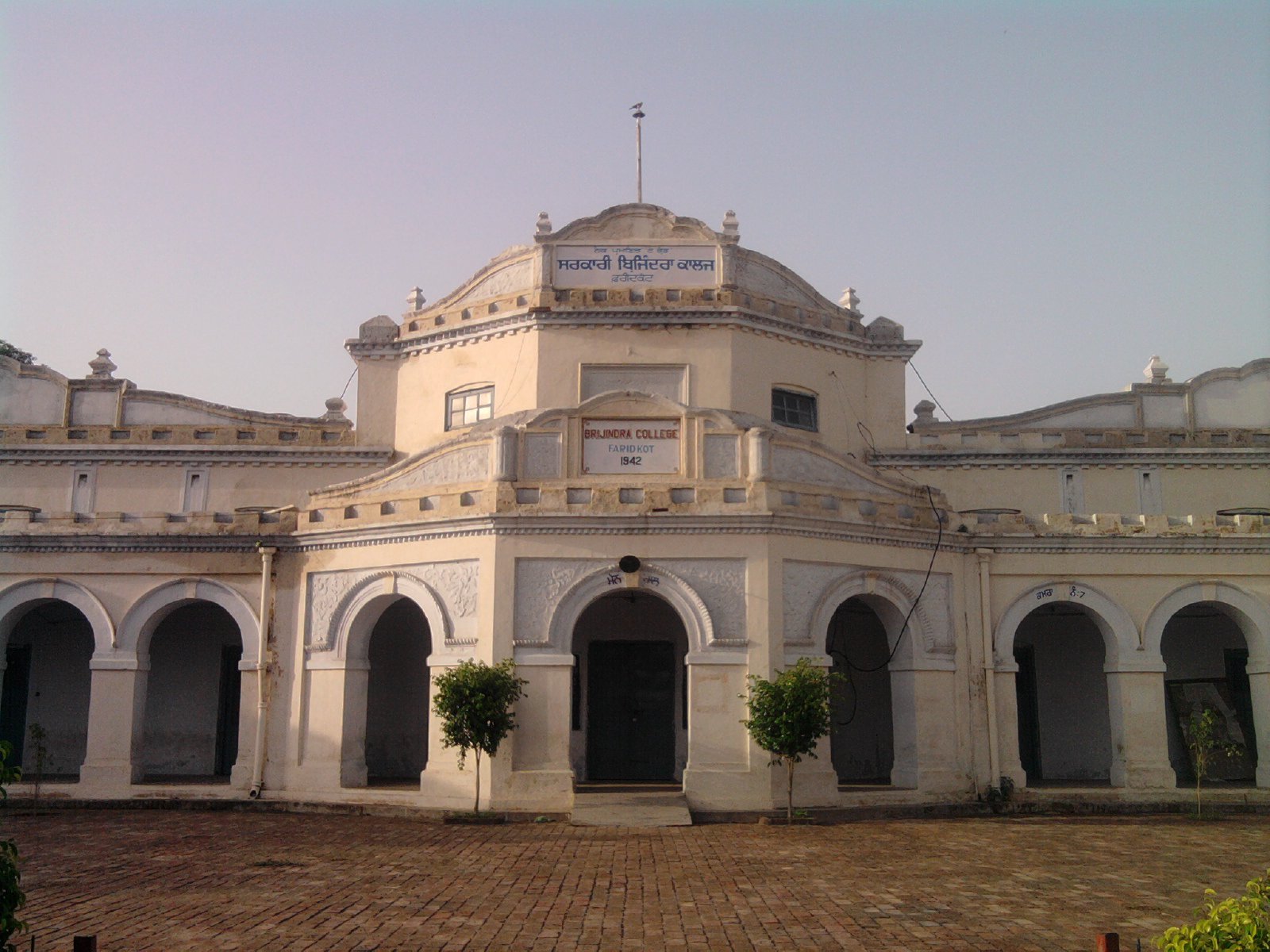 Govt.Brijindra College Faridkot


List of villages
- Ajit Gill
- Ahal
- Arayanwala Kalan
- Arayanwala Khurd
- Aulakh
- Bagiana
- Bajakhana
- Bargari
- Beguwala
- Behbal kalan
- Behbal khurd
- Bhag Singhwala
- Bhagta Bhai Ka
- Bhagthala Kalan
- Bhagthala Khurd
- Bhairon-Ki-Bhatti
- Bhana
- Bhilewala
- Bholuwala
- Bir Bholuwala
- Bir Chahal
- Bir Sikhanwala
- Burj Jwahar singh
- Burj Masta
- Buttar
- Chahal
- Chak Dhudi
- Chak Kalyan
- Chak Sahu
- Chak Seman
- Chak Shama
- Chambeli
- Chand baja
- Chaina
- Chet Singhwala
- Chugewala
- Dabrikhana
- Daggo Romana
- Dalewala
- Dana Romana
- Dawareana
- Deep Singhwala
- Deviwala
- Dhab Sher Singhwala
- Dhaipai
- Dhilwan Kalan
- Dhilwan Khurd
- Dhimanwali
- Dhudi
- Dhurkot
- Dod
- Faridkot (Rural)
- Ghaniewala
- Ghoniwala
- Ghuduwala
- Ghugiana
- Ghumiara
- GONDARA
- Golewala
- Gurusar
- Hadialana
- Hari Nau
- Hariewala
- Hassan Bhatti
- Jalaleana
- Jandwala
- Janerian
- Jeonwala
- Jhakhar Wala
- Jhariwala
- Jhok Sarkari
- Jhotiwala
- Kabalwala
- Kamiana
- Kanianwali
- Kaler
- Kauni
- Khara
- Khemuana
- Khilchi
- Kingra
- Koharwala
- Kotha Guru
- Kothe Kehar Singh
- Kot Sukhia
- lambwali
- Malla
- Matta
- Machaki Kalan
- Machaki Khurd
- Machaki Mal Singh
- Madahar
- Mallewala
- Mandwala
- Mani Singhwala
- Maur
- Mehmuana
- Midu Maan
- Mishriwala
- Moranwali
- Mumaru
- Nangal
- Naraingarh
- Nathalwala
- Nathewala
- Pakhi Kalan
- Pakhi Khurd
- Pakka
- Panjgrain Kalan
- Pehluwala
- Phide Kalan
- Phide Khurd
- Pindi Balochan
- Pipli
- Qila Nau
- Rajowala
- Rattirori
- Rupianwala
- Sadhanwala
- Sadhuwala
- Sadiq
- Saideke
- Sandhwan
- Sangatpura
- Sango Romana
- Sangrahoor
- Sher Singhwala
- Sibbian
- Sikhanwala
- Simrewala
- Sirsari
- Sukhanwala
- Tehna
- Thara
- Virewala kalan
- Virewala Khurd
- Wander Jatana
- Wara Daraka
- Rorikapura
Demographics
According to the 2011 census Faridkot district has a population of 617,508,[3] roughly equal to the nation of Solomon Islands[4] or the US state of Vermont.[5] This gives it a ranking of 519th in India (out of a total of 640).[3] The district has a population density of 424 inhabitants per square kilometre (1,100/sq mi) .[3] Its population growth rate over the decade 2001-2011 was 12.18%.[3] Faridkot has a sex ratio of 889 females for every 1000 males,[3] and a literacy rate of 70.6%.[3]
References
- ↑ Decadal Variation In Population Since 1901
- ↑ "Faridkot District Population Census 2011-2021, Punjab literacy sex ratio and density".
- ↑ 3.0 3.1 3.2 3.3 3.4 3.5 "District Census 2011". Census2011.co.in. 2011. Retrieved 30 September 2011.
- ↑ US Directorate of Intelligence. "Country Comparison:Population". Retrieved 1 October 2011.
Solomon Islands 571,890 July 2011 est.
- ↑ "2010 Resident Population Data". U. S. Census Bureau. Archived from the original on 19 October 2013. Retrieved 2011-09-30.
Vermont 625,741
External links
Places adjacent to Faridkot district | ||||||||||
|---|---|---|---|---|---|---|---|---|---|---|
| ||||||||||




| Topics |  | |
|---|---|---|
| Administration | ||
| Culture |
| |
| Divisions |
| |
| Districts | ||
| Major Cities | ||