.svg)
Uttar Pradesh: Difference between revisions
(Add History) |
No edit summary |
||
| Line 9: | Line 9: | ||
| etymology = ''Uttar'' (meaning 'north') and ''[[Pradesh]]'' (meaning 'province or territory') | | etymology = ''Uttar'' (meaning 'north') and ''[[Pradesh]]'' (meaning 'province or territory') | ||
| type = [[States and union territories of India|State]] | | type = [[States and union territories of India|State]] | ||
| image_flag = Indian state flag of Uttar Pradesh (proposed).png | |||
| flag_type = | |||
| image_blank_emblem = | | image_blank_emblem = | ||
| blank_emblem_type = [[Emblem of Uttar Pradesh|Emblem]] | | blank_emblem_type = [[Emblem of Uttar Pradesh|Emblem]] | ||
| Line 103: | Line 105: | ||
| region_type = <!-- Type of state or region (default is State) --> | | region_type = <!-- Type of state or region (default is State) --> | ||
| country = <!-- e.g., India --> | | country = <!-- e.g., India --> | ||
| flag = | | flag = [[File:Indian state flag of Uttar Pradesh (proposed).png|75px]] {{nowrap|UP Government Flag}} | ||
| emblem = [[File:UP Government Emblem.png|75px]] {{nowrap|UP Government Emblem}} | | emblem = [[File:UP Government Emblem.png|75px]] {{nowrap|UP Government Emblem}} | ||
| nickname = | | nickname = | ||
| Line 207: | Line 209: | ||
==Provincial symbols of Uttar Pradesh== | ==Provincial symbols of Uttar Pradesh== | ||
<gallery> | <gallery> | ||
Image:Indian state flag of Uttar Pradesh (proposed).png|Provincial flag of Uttar Pradesh | |||
Image:Sarus Crane I IMG 8628.jpg|Provincial bird of Uttar Pradesh, the [[Sarus Crane]] | Image:Sarus Crane I IMG 8628.jpg|Provincial bird of Uttar Pradesh, the [[Sarus Crane]] | ||
Image:Barasingha.jpg|Provincial animal of Uttar Pradesh | Image:Barasingha.jpg|Provincial animal of Uttar Pradesh | ||
Revision as of 15:42, 17 October 2021
Uttar Pradesh | |
|---|---|
.jpeg)   .jpg)   From top, left to right: Taj Mahal, Prem Mandir, Vrindavan in Vrindavan, Fatehpur Sikri, Sarnath, Manikarnika Ghat, New Yamuna Bridge | |
| Etymology: Uttar (meaning 'north') and Pradesh (meaning 'province or territory') | |
 Location of Uttar Pradesh in India | |
 | |
| Coordinates: 26°51′N 80°55′E / 26.85°N 80.91°ECoordinates: 26°51′N 80°55′E / 26.85°N 80.91°E | |
| Country | |
| Statehood | 24 January 1950[1] |
| Capital | Lucknow |
| Largest city | Lucknow |
| Districts | 75[2][3] |
| Government | |
| • Body | Government of Uttar Pradesh |
| • Governor | Anandiben Patel[4][5] |
| • Chief Minister | Yogi Adityanath (BJP) |
| • Deputy Chief Ministers | Keshav Prasad Maurya (BJP) Dinesh Sharma (BJP) |
| • Legislature | Bicameral |
| • Parliamentary constituency | |
| Area | |
| • Total | 240,928 km2 (93,023 sq mi) |
| • Rank | 4th |
| Highest elevation (Amsot Peak) | 957 m (3,140 ft) |
| Population (2011) | |
| • Total | 199,812,341 |
| • Rank | 1st |
| • Density | 830/km2 (2,100/sq mi) |
| Demonym | Uttar Pradeshi |
| GDP (2019–20) | |
| • Total | ₹17.94 lakh crore (US$210 billion) |
| • Per capita | ₹70,418 (US$810) |
| Languages[7] | |
| • Official | Hindi |
| • Additional official | Urdu |
| Time zone | UTC+05:30 (IST) |
| UN/LOCODE | IN-UP |
| Vehicle registration | UP XX—XXXX |
| HDI (2018) | |
| Literacy (2011) | 67.68%[9] |
| Sex ratio (2011) | 912 ♀/1000 ♂[9] |
| Website | up |
| Symbols of Uttar Pradesh | |
| Flag | File:Indian state flag of Uttar Pradesh (proposed).png UP Government Flag |
| Emblem |  UP Government Emblem UP Government Emblem |
| Language | Awadhi |
| Mammal | |
| Bird |  |
| Flower | |
| Tree | _flowers_in_Kolkata_W_IMG_4146.jpg) |
Uttar Pradesh (Hindi: उत्तर प्रदेश, Urdu: اتر پردیش) is a state in northern India. For short, people call it UP. Lucknow is the capital city of UP.
The population of the state is 199,581,477 (census 2011). It covers an area of 93,933 mi² (243,286 km²). It is bigger than the United Kingdom but smaller than Guinea. In traditional Indian geography it falls under the North Indian zone.
History
Modern human hunter-gatherers have been in Uttar Pradesh [11] [12] [13] since between around 85,000 and 72,000 years ago. There have also been prehistorical finds in Uttar Pradesh from the Middle and Upper Paleolithic dated to 21,000–31,000 years old[14] and Mesolithic/Microlithic hunter-gatherer settlement, near Pratapgarh, from around 10550–9550 BC. Villages with domesticated cattle, sheep, and goats and evidence of agriculture began as early as 6000 BC, and gradually developed between c. 4000 and 1500 BC beginning with the Indus Valley Civilisation and Harappa Culture to the Vedic period and extending into the Iron Age.[15][16]
Geography
Uttar Pradesh has a long border with Nepal to the north. Next to it are also the Indian states of Uttarakhand, Himachal Pradesh, Haryana, Delhi, Rajasthan, Madhya Pradesh, Chhattisgarh, Jharkhand and Bihar. There are two geographical main regions:-
- The larger Gangetic Plain in the north: it includes the Ganga-Yamuna Doab; the Ghaghra plains; the Ganga plains and the Terai. It has highly fertile soils and flat topography. There are also many ponds, lakes and rivers.
- The smaller Vindhya Range and plateau region in the south. There are hills, plains, valleys and plateau. It is harder to get water.
Divisions of Uttar Pradesh
- Agra Division
- Allahabad Division
- Azamgarh Division
- Bareilly Division
- Basti Division
- Chitrakoot (Dham) Division
- Devipatan Division
- Faizabad Division
- Gorakhpur Division
- Jhansi Division
- Kanpur Division
- Lucknow Division
- Meerut Division
- Mirzapur Division
- Muradabad Division
- Saharanpur Division
- Varanasi Division
Climate
The climate of Uttar Pradesh is mostly subtropical. However weather conditions change a lot depending on where one lives and the season.
Temperature: The average temperatures vary from 12.5–17.5°C (54.5–63.5°F) in January to 27.5–32.5°C (81.5–90.5°F) in May and June. The highest temperature recorded in the State was 49.9°C (121.8°F). It was at Gonda on May 8, 1958.
Rainfall: Rainfall is between 1,000 and 2,000 mm (40–80 inches) in the east and between 600 and 1,000 mm (24–40 inches) in the west. Most of the rain is due to the southwest monsoon. It lasts from June to September. Consequently, floods are a problem during those seasons. They badly damage crops and property.
Droughts: They occur when the monsoon does not come in the usual season. It leads to crop failure.
Snowfall: In the Himalayan region of the State it usually snows from 3 to 5 metres (10 to15 feet) between December and March.
Transportation

Airways: The state has four important airports and 23 air strips. They are in Agra, Kanpur, Lucknow and Varanasi. Lucknow is the biggest and most important airport of the state.
Railways: Almost all the major cities and even some smaller cities are linked. The state has the largest railway network in the country. Its total length is 8,546 km (2006). It has the sixth largest railway density.
Roadways: The state has the largest road network in the country. The biggest is Maharashtra. There are 31 National Highways (NH). In total they are of 4,942 km (8.5% of total NH length in India). It has the seventh highest road density in the India (1,027 km per 1000 km2 in 2002). It also has the largest surfaced urban road network in the country (50,721 km, as on 2002). Cities of Kanpur, Lucknow, Bareilly, Allahabad, Varanasi, Jhansi, Gorakhpur, Noida, Ghaziabad, Meerut, Mathura, Agra and Ghazipur are connected to many National Highways.
Waterways: The river Ganges - from Allahabad (Uttar Pradesh) to Haldia (West Bengal) - has been declared as National Waterway (NW)-I and 600 km of the total NW-I lies in Uttar Pradesh.
Provincial symbols of Uttar Pradesh
- Indian state flag of Uttar Pradesh (proposed).png
Provincial flag of Uttar Pradesh

Provincial bird of Uttar Pradesh, the Sarus Crane
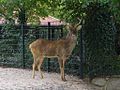
Provincial animal of Uttar Pradesh

Provincial tree of Uttar Pradesh
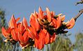
Provincial flower of Uttar Pradesh


_leaves_%26_flowers_in_Kolkata_W_IMG_2272.jpg)

.png)
| States | Andhra Pradesh • Arunachal Pradesh • Assam • Bihar • Chhattisgarh • Goa • Gujarat • Haryana • Himachal Pradesh • Jharkhand • Karnataka • Kerala • Madhya Pradesh • Maharashtra • Manipur • Meghalaya • Mizoram • Nagaland • Odisha • Punjab • Rajasthan • Sikkim • Tamil Nadu • Telangana • Uttar Pradesh • Uttarakhand • West Bengal | |
|---|---|---|
| Union Territories | ||
- ↑ "United Province, UP was notified in Union gazette on January 24, 1950". The New Indian Express. 2 May 2017. Archived from the original on 8 May 2017. Retrieved 4 May 2017.
- ↑ "Uttar Pradesh District". up.gov.in. Government of Uttar Pradesh. Archived from the original on 15 April 2017. Retrieved 12 April 2017.
- ↑ "List of districts in Uttar Pradesh". archive.india.gov.in. Government of India. Archived from the original on 26 April 2017. Retrieved 12 April 2017.
- ↑ PTI (20 July 2019). "Anandiben Patel made UP governor, Lal ji Tandon to replace her in Madhya Pradesh". India Today. Archived from the original on 20 July 2019. Retrieved 20 July 2019.
- ↑ "The Governor of Uttar Pradesh". uplegisassembly.gov.in. Uttar Pradesh Legislative Assembly. Archived from the original on 3 May 2017. Retrieved 12 April 2017.
- ↑ "MOSPI Net State Domestic Product, Ministry of Statistics and Programme Implementation, Government of India". Archived from the original on 23 March 2020. Retrieved 7 April 2020.
- ↑ Cite error: Invalid
<ref>tag; no text was provided for refs named2011lang - ↑ "Sub-national HDI – Area Database". Global Data Lab. Institute for Management Research, Radboud University. Archived from the original on 23 September 2018. Retrieved 25 September 2018.
- ↑ 9.0 9.1 "Census 2011 (Final Data) – Demographic details, Literate Population (Total, Rural & Urban)" (PDF). planningcommission.gov.in. Planning Commission, Government of India. Archived from the original (PDF) on 27 January 2018. Retrieved 3 October 2018.
- ↑ "Statistics of Uttar Pradesh". up.gov.in. Government of Uttar Pradesh. Archived from the original on 12 April 2017. Retrieved 12 April 2017.
- ↑ https://books.google.co.in/books?id=gMoJj-0Z94UC&pg=PA69&redir_esc=y#v=onepage&q&f=false
- ↑ https://books.google.co.in/books?id=r4s-YsP6vcIC&pg=PA58&redir_esc=y#v=onepage&q&f=false
- ↑ https://books.google.co.in/books?id=35DP1Z-2dnYC&pg=PA96&redir_esc=y#v=onepage&q&f=false
- ↑ https://www.sciencedirect.com/science/article/abs/pii/S0277379107003162?via%3Dihub
- ↑ https://books.google.co.in/books?id=W6zQHNavWlsC&pg=PA263&redir_esc=y
- ↑ https://books.google.co.in/books?id=r4s-YsP6vcIC&pg=PA119&redir_esc=y#v=onepage&q&f=false