
imported>DiplomatTesterMan m ce |
minor edit |
||
| (One intermediate revision by one other user not shown) | |||
| Line 1: | Line 1: | ||
{{Use British English|date=September 2012}} | {{Use British English|date=September 2012}} | ||
{{Use dmy dates|date=December 2020}} | {{Use dmy dates|date=December 2020}} | ||
{{Infobox | {{Infobox settlement | ||
| name = Upper Subansiri district | | name = Upper Subansiri district | ||
| total_type = Total | | total_type = Total | ||
| native_name = | | native_name = | ||
| image_map = Arunachal Pradesh | | image_map = Upper Subansiri in Arunachal Pradesh (India).svg | ||
| map_caption = Location | | map_alt = | ||
| map_caption = Location in Arunachal Pradesh | |||
| coordinates = {{Coord|28|18|N|94|00|E|region:IN_type:adm2nd|display=inline,title}} | | coordinates = {{Coord|28|18|N|94|00|E|region:IN_type:adm2nd|display=inline,title}} | ||
| coor_pinpoint = Daporijo | | coor_pinpoint = Daporijo | ||
| Line 12: | Line 13: | ||
| subdivision_name = {{flag|India}} | | subdivision_name = {{flag|India}} | ||
| subdivision_type1 = [[States and union territories of India|State]] | | subdivision_type1 = [[States and union territories of India|State]] | ||
| subdivision_name1 = | | subdivision_name1 = [[Arunachal Pradesh]] | ||
| subdivision_type2 = | | subdivision_type2 = | ||
| subdivision_name2 = | | subdivision_name2 = | ||
| Line 25: | Line 26: | ||
| area_footnotes = | | area_footnotes = | ||
| population_as_of = 2011 | | population_as_of = 2011 | ||
| population_total = 83,448<ref name=districtcensus>{{cite web |url=http://www.census2011.co.in/district.php |title= District Census 2011 |publisher=Census2011.co.in }}</ref> | | population_total = 83,448 | ||
| population_footnotes = <ref name=districtcensus>{{cite web |url=http://www.census2011.co.in/district.php |title=District Census 2011 |publisher=Census2011.co.in |access-date=21 September 2011 |archive-date=11 June 2011 |archive-url=https://web.archive.org/web/20110611224943/http://www.census2011.co.in/district.php |url-status=live }}</ref> | |||
| population_urban = | | population_urban = | ||
| population_density_km2 = auto | | population_density_km2 = auto | ||
| Line 35: | Line 36: | ||
| demographics1_info2 = 982<ref name=districtcensus /> | | demographics1_info2 = 982<ref name=districtcensus /> | ||
| leader_title = [[District collector]] | | leader_title = [[District collector]] | ||
| leader_name = Danish Ashraf , IAS | | leader_name = Danish Ashraf, IAS | ||
| leader_title1 = | | leader_title1 = | ||
| leader_name1 = | | leader_name1 = | ||
| Line 56: | Line 57: | ||
}} | }} | ||
'''Upper Subansiri''' (Pron:/su:bənˈsɪɹi/) is an administrative district in the state of [[Arunachal Pradesh]] in India. | '''Upper Subansiri district''' (Pron:/su:bənˈsɪɹi/) is an administrative district in the state of [[Arunachal Pradesh]] in India. | ||
==History== | ==History== | ||
The district was formed when Subansiri district was bifurcated into Upper and [[Lower Subansiri district]]s in | The district was formed when Subansiri district was bifurcated into Upper and [[Lower Subansiri district]]s in 1980.<ref name='Statoids'>{{cite web | url = http://www.statoids.com/yin.html | title = Districts of India | access-date = 2011-10-11 | last = Law | first = Gwillim | date = 25 September 2011 | work = Statoids | archive-date = 29 November 2010 | archive-url = https://web.archive.org/web/20101129043227/http://statoids.com/yye.html | url-status = live }}</ref> | ||
==Geography== | ==Geography== | ||
Upper Subansiri district occupies an area of {{convert|7032|km2|sqmi}},<ref name='Reference Annual'>{{cite book | last1 = Srivastava, Dayawanti et al. (ed.) | title = India 2010: A Reference Annual | chapter = States and Union Territories: Arunachal Pradesh: Government | edition = 54th | publisher = Additional Director General, Publications Division, [[Ministry of Information and Broadcasting (India)]], [[Government of India]] | year = 2010 | location = New Delhi, India | pages = 1113 | isbn = 978-81-230-1617-7}}</ref> comparatively equivalent to the United Kingdom's [[East Falkland]] island.<ref name="Islands">{{cite web | url = http://islands.unep.ch/Tiarea.htm | title = Island Directory Tables: Islands by Land Area | access-date = 2011-10-11 | date = 18 February 1998 | publisher = [[United Nations Environment Program]] | quote = East Falkland 7,040km2 | archive-date = 20 February 2018 | archive-url = https://web.archive.org/web/20180220003634/http://islands.unep.ch/Tiarea.htm | url-status = live }}</ref> | |||
The district headquarter is located at [[Daporijo]]. The important towns are [[Chetam]], [[Giba]], [[Taksing]], [[Limeking]], [[Nacho, Arunachal Pradesh|Nacho]], Siyum, [[Payeng]], [[Taliha]], [[Gite Ripa]], [[Gussar]], [[Dumporijo]], [[Daporijo]], [[Maro, Arunachal Pradesh|Maro]], [[Baririjo]] and [[Puchigeku]], each of which is the headquarters of a [[tehsil|circle]]. | |||
==Transport== | ==Transport== | ||
The {{convert|2000|km|mi|adj=mid|-long}} | The proposed {{convert|2000|km|mi|adj=mid|-long}} Mago-[[Thingbu]] to [[Vijaynagar, Changlang|Vijaynagar]] [[Mago-Thingbu to Vijaynagar Border Road|Arunachal Pradesh Frontier Highway]] along the [[McMahon Line]],<ref name=BR1>{{cite web|title=Top officials to meet to expedite road building along China border|url=http://timesofindia.indiatimes.com/india/Top-officials-to-meet-to-expedite-road-building-along-China-border/articleshow/44831871.cms|author=Dipak Kumar Dash|work=The Times of India|access-date=27 October 2014|archive-date=18 October 2014|archive-url=https://web.archive.org/web/20141018192037/http://timesofindia.indiatimes.com/india/Top-officials-to-meet-to-expedite-road-building-along-China-border/articleshow/44831871.cms|url-status=live}}</ref><ref name=BR2>{{cite web|title=Narendra Modi government to provide funds for restoration of damaged highways|url=http://www.dnaindia.com/india/report-narendra-modi-government-to-provide-funds-for-restoration-of-damaged-highways-2020106|publisher=www.dnaindia.com|access-date=27 October 2014|archive-date=27 October 2014|archive-url=https://web.archive.org/web/20141027082007/http://www.dnaindia.com/india/report-narendra-modi-government-to-provide-funds-for-restoration-of-damaged-highways-2020106|url-status=live}}</ref><ref name=BR3>{{cite web|title=Indian Government Plans Highway Along Disputed China Border|url=https://thediplomat.com/2014/10/indian-government-plans-highway-along-disputed-china-border/|work=Ankit Panda|publisher=thediplomat.com|access-date=27 October 2014|archive-date=18 October 2014|archive-url=https://web.archive.org/web/20141018054055/https://thediplomat.com/2014/10/indian-government-plans-highway-along-disputed-china-border/|url-status=live}}</ref><ref name=BR4>{{cite web |url= http://www.livemint.com/Politics/nqEwdXxkIgrSHPpTSzsFRN/Govt-planning-road-along-McMohan-line-in-Arunachal-Pradesh.html |title= Govt planning road along McMohan line in Arunachal Pradesh: Kiren Rijiju |date= 14 October 2014 |publisher= Live Mint |access-date= 2014-10-26 |archive-date= 2 December 2014 |archive-url= https://web.archive.org/web/20141202035956/http://www.livemint.com/Politics/nqEwdXxkIgrSHPpTSzsFRN/Govt-planning-road-along-McMohan-line-in-Arunachal-Pradesh.html |url-status= live }}</ref> (will intersect with the proposed [[East-West Industrial Corridor Highway, Arunachal Pradesh|East-West Industrial Corridor Highway]]) and will pass through this district, alignment map of which can be seen [http://www.tribuneindia.com/2014/20141016/nat7.jpg here] and [https://web.archive.org/web/20160306112247/http://arunachalpradesh.nic.in/images/state_map.jpg here].<ref name=BR5>{{cite web|url=http://www.tribuneindia.com/2014/20141016/nation.htm|title=China warns India against paving road in Arunachal|work=Ajay Banerjee|publisher=tribuneindia.com|access-date=2014-10-26|archive-date=27 October 2014|archive-url=https://web.archive.org/web/20141027064234/http://www.tribuneindia.com/2014/20141016/nation.htm|url-status=live}}</ref> | ||
==Divisions== | ==Divisions== | ||
There are four [[Arunachal Pradesh Legislative Assembly]] constituencies in this district: Nacho, Taliha, Daporijo | There are four [[Arunachal Pradesh Legislative Assembly]] constituencies in this district: [[Nacho (Vidhan Sabha constituency)|Nacho]], [[Taliha (Vidhan Sabha constituency)|Taliha]], [[Daporijo (Vidhan Sabha constituency)|Daporijo]] and [[Dumporijo (Vidhan Sabha constituency)|Dumporijo]]. All of these are part of [[Arunachal West (Lok Sabha constituency)|Arunachal West Lok Sabha constituency]].<ref name="ceo1">{{cite web|url=http://ceoarunachal.nic.in/Information/ACwiseDistrictwisePCwise.htm|title=Assembly Constituencies allocation w.r.t District and Parliamentary Constituencies|publisher=Chief Electoral Officer, Arunachal Pradesh website|access-date=21 March 2011|archive-url=https://web.archive.org/web/20110813085549/http://ceoarunachal.nic.in/Information/ACwiseDistrictwisePCwise.htm|archive-date=13 August 2011|url-status=dead}}</ref> | ||
==Demographics== | ==Demographics== | ||
{{historical populations|23=1961|24=24,481|25=1971|26=32,014|27=1981|28=39,410|29=1991|30=50,086|31=2001|32=55,346|33=2011|34=83,448|percentages=pagr|footnote=source:<ref> | {{historical populations|23=1961|24=24,481|25=1971|26=32,014|27=1981|28=39,410|29=1991|30=50,086|31=2001|32=55,346|33=2011|34=83,448|percentages=pagr|footnote=source:<ref>{{Cite web |url=http://www.censusindia.gov.in/2011census/PCA/A2_Data_Table.html |title=Decadal Variation In Population Since 1901 |access-date=12 August 2019 |archive-date=26 February 2022 |archive-url=https://web.archive.org/web/20220226150601/https://censusindia.gov.in/2011census/PCA/A-2_Data_Tables/10%20A-2%20Bihar.pdf |url-status=live }}</ref>|align=right}}According to the [[2011 census of India|2011 census]], Upper Subansiri district has a [[Demographics of India|population]] of 83,448,<ref name=district_census>{{cite web | url = http://www.census2011.co.in/district.php | title = District Census 2011 | access-date = 2011-09-30 | year = 2011 | publisher = Census2011.co.in | archive-date = 11 June 2011 | archive-url = https://web.archive.org/web/20110611224943/http://www.census2011.co.in/district.php | url-status = live }}</ref> roughly equal to the nation of [[Andorra]].<ref name="cia">{{cite web | author = US Directorate of Intelligence | title = Country Comparison:Population | url = https://www.cia.gov/library/publications/the-world-factbook/rankorder/2119rank.html | archive-url = https://web.archive.org/web/20070613004507/https://www.cia.gov/library/publications/the-world-factbook/rankorder/2119rank.html | url-status = dead | archive-date = 13 June 2007 | access-date = 2011-10-01 | quote =198 Andorra 84,825 July 2011 est. | ||
}}</ref> This gives it a ranking of 621st in India (out of a total of [[Districts of India|640]]).<ref name=district_census/> The district has a population density of {{convert| 12 |PD/sqkm|PD/sqmi}} .<ref name=district_census/> | }}</ref> This gives it a ranking of 621st in India (out of a total of [[Districts of India|640]]).<ref name=district_census/> The district has a population density of {{convert| 12 |PD/sqkm|PD/sqmi}} .<ref name=district_census/> The [[Family planning in India|population growth rate]] in the 2001–2011 decade was 50.34%.<ref name=district_census/> Upper Subansiri has a [[sex ratio]] of 982 [[Women in India|females]] for every 1000 males,<ref name=district_census/> and a [[Literacy in India|literacy rate]] of 63.96%. Scheduled Tribes make up 93.86% of the population.<ref name=district_census/> | ||
{{bar box | |||
|title=Religions in Upper Subansiri district (2011)<ref name="Religion">{{cite web|title=C-16 Population By Religion – Arunachal Pradesh|url=http://www.censusindia.gov.in/2011census/C-01/DDW00C-01%20MDDS.XLS|website=census.gov.in|publisher=Office of the Registrar General & Census Commissioner, India|access-date=20 March 2022|archive-date=25 August 2015|archive-url=https://web.archive.org/web/20150825155850/http://www.censusindia.gov.in/2011census/C-01/DDW00C-01%20MDDS.XLS|url-status=live}}</ref> | |||
|titlebar=#FCD116 | |||
|left1=Religion | |||
|right1=Per cent | |||
|float=left | |||
|bars= | |||
{{bar percent|[[Donyi-Polo]]|red|71.24}} | |||
{{bar percent|[[Hinduism]]|darkorange|16.15}} | |||
{{bar percent|[[Christianity in Arunachal Pradesh|Christianity]]|dodgerblue|10.52}} | |||
{{bar percent|[[Islam]]|green|0.62}} | |||
{{bar percent|Other or not stated|black|1.47}} | |||
}} | |||
{{Pie chart | |||
| thumb = right | |||
| caption = Languages of Upper Subansiri District (2011)<ref name="Census of India">{{Cite web |url=https://censusindia.gov.in/2011census/C-16/DDW-C16-STMT-MDDS-1200.XLSX |title=Census of India Website : Office of the Registrar General & Census Commissioner, India |website=www.censusindia.gov.in}}</ref> | |||
| label1 = [[Taginlanguage|Tagin]] | |||
| value1 = 78.71 | |||
| color1 = Darkblue | |||
| label2 = Galo | |||
| value2 = 14.95 | |||
| color2 = Deepskyblue | |||
| label3 = [[Hindi]] | |||
| value3 = 2.26 | |||
| color3 = Orange | |||
| label4 = [[Nepali language|Nepali]] | |||
| value4 = 1.05 | |||
| color4 = Sienna | |||
| label5 = Others | |||
| value5 = 3.03 | |||
| color5 = Grey | |||
}} | |||
At the time of the 2011 census, 69.17% of the population spoke [[Bangni-Tagin language|Tagin]], 14.30% [[Galo language|Galo]], 9.30% [[Nishi language|Nyishi]], 1.14% [[Bhojpuri language|Bhojpuri]] and 1.05% [[Nepali language|Nepali]] as their first language.<ref>{{Cite web |url=http://www.censusindia.gov.in/2011census/C-16.html |title=2011 Census of India, Population By Mother Tongue |access-date=20 March 2022 |archive-date=15 August 2018 |archive-url=https://web.archive.org/web/20180815035759/http://www.censusindia.gov.in/2011census/C-16.html |url-status=live }}</ref> | |||
==Education== | ==Education== | ||
[[Jawahar Navodaya Vidyalaya, Megdong]] for Upper Subansiri district is located | [[Jawahar Navodaya Vidyalaya, Megdong]] for Upper Subansiri district is located about 10 km east from the administrative headquarter [[Daporijo]]. | ||
== Tourism == | == Tourism == | ||
Tourist sites in the area include: | Tourist sites in the area include: | ||
* '''Aato Topo statue''' at Dumporijo; | * '''Aato Topo statue''' at Dumporijo; Ato Topo is the forefather of the Topo clan. Topo welfare society based in Dumporijo built a statue of Ato Topo at Dumporijo in Feb 2004. Dumporijo is located about 15 kilometers far, easterly to Daporijo, the district head-quarters.<ref>https://www.arunachaltimes.in/archives/feb14%2004.html</ref> | ||
* '''Menga mandir:''' a cave mandir with a huge Shiva Linga inside. The cave has two caves within, which goes down about 8 meters. | * '''Menga mandir:''' a cave mandir with a huge Shiva Linga inside. The cave has two caves within, which goes down about 8 meters. | ||
* '''Jalang waterfall''' at Timba village | * '''Jalang waterfall''' at Timba village | ||
* '''Keba Somara''' village where there is Yechung Gambung{{clarify|date=July 2018}} in the Subansiri river, which is believed to be linked to a cave/large crack in the mountain, 2 km away and has an associated history. | * '''Keba Somara''' village where there is Yechung Gambung{{clarify|date=July 2018}} in the Subansiri river, which is believed to be linked to a cave/large crack in the mountain, 2 km away and has an associated history. | ||
* '''Lingpi ligne''' at Dupit village has a huge Shiva Linga shaped stone (Lingpi coming out from earth) which has a | * '''Lingpi ligne''' at Dupit village has a huge Shiva Linga shaped stone (Lingpi coming out from earth) which has a | ||
* '''Achin Muri''' is a historical place associated with the massacre of Indian Army in | * '''Achin Muri''' is a historical place associated with the massacre of Indian Army in 1953 | ||
* '''Sher-e-Thappa | * '''Sher-e-Thappa statue''' commemorating an engagement with the Chinese for 72 hours in 1962 Indo-China war | ||
Also, there is trekking from Siyum to Mechuka through the snow-laden Tikuk pass in the Tikuk mountain (during November). This trade route | Also, there is trekking from Siyum to Mechuka through the snow-laden Tikuk pass in the Tikuk mountain (during November). This trade route | ||
was part of the established barter practice between Tibet and the | was part of the established barter practice between Tibet and the | ||
tribes in the region during 20th C.<ref>{{Cite web|url = http://www.echoofarunachal.in/newsdetails.php?nid=ECHO20150512000627|title = Exploring the unexplored: A case of tourism development for Upper Subansiri dist: By Nyatum Doke}}</ref> | tribes in the region during 20th C.<ref>{{Cite web|url = http://www.echoofarunachal.in/newsdetails.php?nid=ECHO20150512000627|title = Exploring the unexplored: A case of tourism development for Upper Subansiri dist: By Nyatum Doke|access-date = 4 September 2015|archive-date = 4 March 2016|archive-url = https://web.archive.org/web/20160304002713/http://www.echoofarunachal.in/newsdetails.php?nid=ECHO20150512000627|url-status = live}}</ref> | ||
==References== | ==References== | ||
Latest revision as of 19:52, 11 October 2025
Upper Subansiri district | |
|---|---|
.svg) Location in Arunachal Pradesh | |
 Upper Subansiri district with administrative circles and other labels | |
| Coordinates (Daporijo): 28°18′N 94°00′E / 28.300°N 94.000°E | |
| Country |  India India |
| State | Arunachal Pradesh |
| Headquarters | Daporijo |
| Government | |
| • District collector | Danish Ashraf, IAS |
| Area | |
| • Total | 7,032 km2 (2,715 sq mi) |
| Population (2011)[1] | |
| • Total | 83,448 |
| • Density | 12/km2 (31/sq mi) |
| Demographics | |
| • Literacy | 64.0%[1] |
| • Sex ratio | 982[1] |
| Time zone | UTC+05:30 (IST) |
| Website | uppersubansiri |
Upper Subansiri district (Pron:/su:bənˈsɪɹi/) is an administrative district in the state of Arunachal Pradesh in India.
History[edit | edit source]
The district was formed when Subansiri district was bifurcated into Upper and Lower Subansiri districts in 1980.[2]
Geography[edit | edit source]
Upper Subansiri district occupies an area of 7,032 square kilometres (2,715 sq mi),[3] comparatively equivalent to the United Kingdom's East Falkland island.[4]
The district headquarter is located at Daporijo. The important towns are Chetam, Giba, Taksing, Limeking, Nacho, Siyum, Payeng, Taliha, Gite Ripa, Gussar, Dumporijo, Daporijo, Maro, Baririjo and Puchigeku, each of which is the headquarters of a circle.
Transport[edit | edit source]
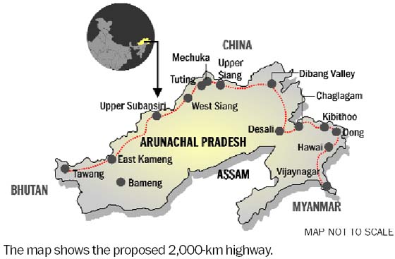
The proposed 2,000-kilometre-long (1,200 mi) Mago-Thingbu to Vijaynagar Arunachal Pradesh Frontier Highway along the McMahon Line,[5][6][7][8] (will intersect with the proposed East-West Industrial Corridor Highway) and will pass through this district, alignment map of which can be seen here and here.[9]
Divisions[edit | edit source]
There are four Arunachal Pradesh Legislative Assembly constituencies in this district: Nacho, Taliha, Daporijo and Dumporijo. All of these are part of Arunachal West Lok Sabha constituency.[10]
Demographics[edit | edit source]
| Year | Pop. | ±% p.a. |
|---|---|---|
| 1961 | 24,481 | — |
| 1971 | 32,014 | +2.72% |
| 1981 | 39,410 | +2.10% |
| 1991 | 50,086 | +2.43% |
| 2001 | 55,346 | +1.00% |
| 2011 | 83,448 | +4.19% |
| source:[11] | ||
According to the 2011 census, Upper Subansiri district has a population of 83,448,[12] roughly equal to the nation of Andorra.[13] This gives it a ranking of 621st in India (out of a total of 640).[12] The district has a population density of 12 inhabitants per square kilometre (31/sq mi) .[12] The population growth rate in the 2001–2011 decade was 50.34%.[12] Upper Subansiri has a sex ratio of 982 females for every 1000 males,[12] and a literacy rate of 63.96%. Scheduled Tribes make up 93.86% of the population.[12]
At the time of the 2011 census, 69.17% of the population spoke Tagin, 14.30% Galo, 9.30% Nyishi, 1.14% Bhojpuri and 1.05% Nepali as their first language.[16]
Education[edit | edit source]
Jawahar Navodaya Vidyalaya, Megdong for Upper Subansiri district is located about 10 km east from the administrative headquarter Daporijo.
Tourism[edit | edit source]
Tourist sites in the area include:
- Aato Topo statue at Dumporijo; Ato Topo is the forefather of the Topo clan. Topo welfare society based in Dumporijo built a statue of Ato Topo at Dumporijo in Feb 2004. Dumporijo is located about 15 kilometers far, easterly to Daporijo, the district head-quarters.[17]
- Menga mandir: a cave mandir with a huge Shiva Linga inside. The cave has two caves within, which goes down about 8 meters.
- Jalang waterfall at Timba village
- Keba Somara village where there is Yechung Gambung[clarification needed] in the Subansiri river, which is believed to be linked to a cave/large crack in the mountain, 2 km away and has an associated history.
- Lingpi ligne at Dupit village has a huge Shiva Linga shaped stone (Lingpi coming out from earth) which has a
- Achin Muri is a historical place associated with the massacre of Indian Army in 1953
- Sher-e-Thappa statue commemorating an engagement with the Chinese for 72 hours in 1962 Indo-China war
Also, there is trekking from Siyum to Mechuka through the snow-laden Tikuk pass in the Tikuk mountain (during November). This trade route was part of the established barter practice between Tibet and the tribes in the region during 20th C.[18]
References[edit | edit source]
- ↑ 1.0 1.1 1.2 "District Census 2011". Census2011.co.in. Archived from the original on 11 June 2011. Retrieved 21 September 2011.
- ↑ Law, Gwillim (25 September 2011). "Districts of India". Statoids. Archived from the original on 29 November 2010. Retrieved 11 October 2011.
- ↑ Srivastava, Dayawanti et al. (ed.) (2010). "States and Union Territories: Arunachal Pradesh: Government". India 2010: A Reference Annual (54th ed.). New Delhi, India: Additional Director General, Publications Division, Ministry of Information and Broadcasting (India), Government of India. p. 1113. ISBN 978-81-230-1617-7.
{{cite book}}:|last1=has generic name (help) - ↑ "Island Directory Tables: Islands by Land Area". United Nations Environment Program. 18 February 1998. Archived from the original on 20 February 2018. Retrieved 11 October 2011.
East Falkland 7,040km2
- ↑ Dipak Kumar Dash. "Top officials to meet to expedite road building along China border". The Times of India. Archived from the original on 18 October 2014. Retrieved 27 October 2014.
- ↑ "Narendra Modi government to provide funds for restoration of damaged highways". www.dnaindia.com. Archived from the original on 27 October 2014. Retrieved 27 October 2014.
- ↑ "Indian Government Plans Highway Along Disputed China Border". Ankit Panda. thediplomat.com. Archived from the original on 18 October 2014. Retrieved 27 October 2014.
- ↑ "Govt planning road along McMohan line in Arunachal Pradesh: Kiren Rijiju". Live Mint. 14 October 2014. Archived from the original on 2 December 2014. Retrieved 26 October 2014.
- ↑ "China warns India against paving road in Arunachal". Ajay Banerjee. tribuneindia.com. Archived from the original on 27 October 2014. Retrieved 26 October 2014.
- ↑ "Assembly Constituencies allocation w.r.t District and Parliamentary Constituencies". Chief Electoral Officer, Arunachal Pradesh website. Archived from the original on 13 August 2011. Retrieved 21 March 2011.
- ↑ "Decadal Variation In Population Since 1901". Archived (PDF) from the original on 26 February 2022. Retrieved 12 August 2019.
- ↑ 12.0 12.1 12.2 12.3 12.4 12.5 "District Census 2011". Census2011.co.in. 2011. Archived from the original on 11 June 2011. Retrieved 30 September 2011.
- ↑ US Directorate of Intelligence. "Country Comparison:Population". Archived from the original on 13 June 2007. Retrieved 1 October 2011.
198 Andorra 84,825 July 2011 est.
- ↑ "C-16 Population By Religion – Arunachal Pradesh". census.gov.in. Office of the Registrar General & Census Commissioner, India. Archived from the original on 25 August 2015. Retrieved 20 March 2022.
- ↑ "Census of India Website : Office of the Registrar General & Census Commissioner, India". www.censusindia.gov.in.
- ↑ "2011 Census of India, Population By Mother Tongue". Archived from the original on 15 August 2018. Retrieved 20 March 2022.
- ↑ https://www.arunachaltimes.in/archives/feb14%2004.html
- ↑ "Exploring the unexplored: A case of tourism development for Upper Subansiri dist: By Nyatum Doke". Archived from the original on 4 March 2016. Retrieved 4 September 2015.
External links[edit | edit source]
Places adjacent to Upper Subansiri district | ||||||||||
|---|---|---|---|---|---|---|---|---|---|---|
| ||||||||||





.png)