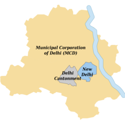
Delhi Cantonment
Delhi Cantonment | |
|---|---|
District Subdivision | |
| Coordinates: 28°35′53″N 77°07′24″E / 28.598091°N 77.1234069°ECoordinates: 28°35′53″N 77°07′24″E / 28.598091°N 77.1234069°E | |
| Country | |
| State | Delhi |
| District | New Delhi |
| Area | |
| • Total | 42.3 km2 (16.3 sq mi) |
| Population (2011)[1] | |
| • Total | 110,351 |
| • Density | 2,600/km2 (6,800/sq mi) |
| Languages | |
| • Official | Hindi, English |
| Time zone | UTC+5:30 (IST) |
| PIN | 110010 |
| Telephone code | 91-011 |
| Website | Official website |
Delhi Cantonment (popularly referred to as Delhi Cantt) is a Class I Cantonment Board established in 1914. The area of the Cantonment is 10,452 acres (42.30 km2) and the population of the Cantonment as per the 2011 census is 110,351.[1]
The Cantonment is governed by the Cantonments Act, 2006[2] while various policy letters and instructions from the Ministry of Defence pertaining to the area are issued from time to time. Although the board functions as a local municipal body, it remains under the administrative control of the Directorate General Defence Estates, New Delhi and Principal Director, Defence Estates, Western Command, Chandigarh.[3]
It is one of three local bodies in the National Capital Territory of Delhi, the others being Municipal Corporation of Delhi and New Delhi Municipal Council.
History[edit | edit source]
Cantonments in Delhi and Ahmedabad were originally established by the British. The Delhi Cantonment houses the Indian Army Headquarters, Delhi Area; the Army Golf Course; the Defence Services Officers Institute; military housing; Army and Air Force Public Schools; and various other defence-related installations. The cantonment also houses the Army Hospital Research and Referral, a tertiary care medical centre of the armed forces of India.
There is a railway station within the cantonment, Delhi Cantonment railway station, from where trains depart for various parts of the country.
Demographics[edit | edit source]
At the 2001 India census[4] Delhi Cantt. had a population of 124,452. Males constituted 61% of the population and females 39%. Delhi Cantt. has an average literacy rate of 77%, higher than the national average of 74%: male literacy is 83% and, female literacy is 68%. In Delhi Cantt., 12% of the population is under 6 years of age.
At the 2011 India census[5] Delhi Cantt. had a population of 116,352. Males constituted ≈58% (67,703) of the population and females constituted ≈42% (48,649). Delhi Cantt. has an average literacy rate of 91.11%, higher than the national average of 79.9%: male literacy is 94.54% and, female literacy is 86.26%. In Delhi Cantt., 11.36% of the population is under 6 years of age.
Facilities[edit | edit source]
Template:Vanchor is located in Delhi Cantonment.[6]
Transport[edit | edit source]
Delhi Cantonment is connected by road, railway and air. Indira Gandhi International Airport is about 5 kilometres from Delhi Cantonment. Its nearest metro stations are Delhi Cantonment, Sadar Bazaar Cantonment and Shankar Vihar metro station. Delhi Cantonment has a railway station. Almost all the trains plying from Delhi towards Rajasthan or Gujarat stop here.
It is easily accessible by road and local bus to the residents of nearby residential neighbourhoods such as Palam, Dwarka, Dhaula Kuan, Tilak Nagar, Vasant Vihar, Naraina and Janakpuri.
References[edit | edit source]
- ↑ 1.0 1.1 1.2 "About Us – DELHI CANTONMENT BOARD". delhi.cantt.gov.in. Retrieved 13 February 2022.
- ↑ Document, http://www.cbdelhi.in/Documents/ca2006.pdf Archived 31 May 2014 at the Wayback Machine
- ↑ "Delhi Cantonment Board, Ministry of Defence". Archived from the original on 31 May 2014. Retrieved 30 May 2014.
- ↑ censusindia.net. 24 November 2001 https://web.archive.org/web/20040616075334/http://www.censusindia.net/results/town.php?stad=A&state5=999. Archived from the original on 16 June 2004. Retrieved 21 December 2022.
{{cite web}}: Missing or empty|title=(help) - ↑ "Delhi Cantonment City Census 2011 data". census2011.co.in. Retrieved 7 July 2018.
- ↑ "Last rites of Rawat, wife Madhulika to be held at Delhi Cantonment crematorium today". Deccan Chronicle. 10 December 2021. Retrieved 12 December 2021.


