



>Explicit m Removing link(s) Wikipedia:Articles for deletion/Gangarampur High School closed as delete (XFDcloser) |
m enhanced references based on references and improved wording |
||
| Line 2: | Line 2: | ||
{{Use Indian English|date=December 2018}} | {{Use Indian English|date=December 2018}} | ||
{{Infobox settlement | {{Infobox settlement | ||
| name | | name = Gangarampur | ||
| other_name | | other_name = | ||
| nickname | | nickname = | ||
| settlement_type | | settlement_type = City | ||
| image_skyline | | image_skyline = | ||
| image_alt | | image_alt = | ||
| image_caption | | image_caption = Punarbhaba Rail Bridge, Gangarampur | ||
| pushpin_map | | pushpin_map = India West Bengal#India3 | ||
| pushpin_label_position = right | | pushpin_label_position = right | ||
| pushpin_map_alt | | pushpin_map_alt = | ||
| pushpin_map_caption | | pushpin_map_caption = Location in West Bengal, India | ||
| coordinates | | coordinates = {{coord|25.4|N|88.52|E|display=inline,title}} | ||
| subdivision_type | | subdivision_type = Country | ||
| subdivision_name | | subdivision_name = {{flag|India}} | ||
| subdivision_type1 | | subdivision_type1 = [[States and territories of India|State]] | ||
| subdivision_name1 | | subdivision_name1 = [[West Bengal]] | ||
| subdivision_type2 | | subdivision_type2 = [[List of districts of India|District]] | ||
| subdivision_name2 | | subdivision_name2 = [[Dakshin Dinajpur]] | ||
| established_title | | established_title = <!-- Established --> | ||
| established_date | | established_date = | ||
| founder | | founder = | ||
| named_for | | named_for = | ||
| government_type | | government_type = [[Municipal Corporations in India|Municipality]] | ||
| governing_body | | governing_body = Gangarampur Municipality | ||
| leader_title | | leader_title = [[Chairman]] | ||
| leader_name | | leader_name = Prasanta Mitra | ||
| leader_title3 = [[Member of Legislative Assembly]] | |||
| leader_name3 = Satyendra Nath Ray | |||
| leader_title4 = [[Member of Parliament]] | |||
| leader_name4 = Sukanta Majumdar, Union Minister of State for MoE and MoDoNER | |||
| unit_pref = Metric | |||
| area_footnotes = <ref name='Gangarampur City'>{{cite web|title=Gangarampur City|url=https://www.sudawb.org/wbdma_oldversion/HTM/DIS/MUNI_ULB_Gangarampur.htm}}</ref> | |||
| leader_title3 | | area_rank = | ||
[[Member of Legislative Assembly]] | | area_total_km2 = 10.29 | ||
| leader_name3 | | elevation_footnotes = | ||
| elevation_m = 25 | |||
| leader_title4 | | population_total = 56175 | ||
[[Member of Parliament]] | | population_as_of = 2011 | ||
|leader_name4 | | population_rank = | ||
| unit_pref | |||
| area_footnotes | |||
| area_rank = | |||
| area_total_km2 | |||
| elevation_footnotes | |||
| elevation_m | |||
| population_total | |||
| population_as_of | |||
| population_rank = | |||
| population_density_km2 = auto | | population_density_km2 = auto | ||
| population_demonym | | population_demonym = | ||
| population_footnotes | | population_footnotes = | ||
| demographics_type1 | | demographics_type1 = Languages | ||
| demographics1_title1 | | demographics1_title1 = Official | ||
| demographics1_info1 | | demographics1_info1 = [[Bengali language|Bengali]], English | ||
| timezone1 | | timezone1 = [[Indian Standard Time|IST]] | ||
| utc_offset1 | | utc_offset1 = +5:30 | ||
| postal_code_type | | postal_code_type = [[Postal Index Number|PIN]] | ||
| postal_code | | postal_code = 733124 | ||
| area_code_type | | area_code_type = Telephone code | ||
| area_code | | area_code = 03521 | ||
| registration_plate | | registration_plate = WB61 - WB62 | ||
| blank1_name_sec1 | | blank1_name_sec1 = [[Lok Sabha]] constituency | ||
| blank1_info_sec1 | | blank1_info_sec1 = [[Balurghat (Lok Sabha constituency)|Balurghat]] | ||
| blank2_name_sec1 | | blank2_name_sec1 = [[Vidhan Sabha]] constituency | ||
| blank2_info_sec1 | | blank2_info_sec1 = [[Gangarampur (Vidhan Sabha constituency)|Gangarampur]] | ||
| website | | website = {{Official website|https://www.gangarampurmunicipality.org/}} | ||
| footnotes | | footnotes = | ||
}} | }} | ||
'''Gangarampur''' is one of the cities and a municipality in [[Dakshin Dinajpur district]] in the state of [[West Bengal]], India. | '''Gangarampur''' is one of the cities and a municipality in [[Dakshin Dinajpur district]] in the state of [[West Bengal]], India. [[Balurghat]] is the headquarters of the [[Gangarampur subdivision|Gangarampur Subdivision]]. The city is located on the bank of river [[Punarbhaba River|Punarbhaba]]. Gangarampur is one of the major cities connected through [[National Highway 512 (India)|National Highway 512]]. It became the subdivision of newly formed district [[Dakshin Dinajpur district|Dakshin Dinajpur]] when Paschim Dinajpur was bifurcated into [[Uttar Dinajpur district|Uttar]] and [[Dakshin Dinajpur district|Dakshin Dinajpur]] in 1992. It was one of the [[Khalji dynasty (Bengal)|Khalji]] capital under [[Muhammad Bakhtiyar Khalji|Muhammad Khalji]].<ref>{{Cite book |last=Kerr-Smiley |first=Mark |url=https://www.google.co.uk/books/edition/Mamluks_Conquest_and_Culture/ijDx0AEACAAJ?hl=en |title=Mamluks, Conquest and Culture: The Ghurid Empire and Early Delhi Sultanate c. 1150-1236 |date= |publisher=Unicorn Publishing Group |year=2025 |isbn=978-1-916846-76-0 |pages=68 |language=en}}</ref> | ||
==Geography== | ==Geography== | ||
| Line 98: | Line 88: | ||
===Location=== | ===Location=== | ||
Gangarampur is located almost in the middle of Dakshin Dinajpur district at {{Coord|25.4|N|88.52|E|}}.<ref>{{cite web|url=http://www.fallingrain.com/world/IN/28/Gangarampur.html|title=Maps, Weather, and Airports for Gangarampur, India|website=www.fallingrain.com}}</ref> It has spread linearly along the banks of the [[Punarbhaba River]].<ref>{{cite web|title=Flood Management, Gangarampur|url=http://www.ddinajpur.nic.in/Flood_Management/Gangarampur/gangarampur.html|publisher=Dakshin Dinajpur district}}</ref> It has an average elevation of 25 metres (82 feet). The area of the city is 10.29 Sq. km.<ref name='Gangarampur City'/> | Gangarampur is located almost in the middle of Dakshin Dinajpur district at {{Coord|25.4|N|88.52|E|}}.<ref>{{cite web|url=http://www.fallingrain.com/world/IN/28/Gangarampur.html|title=Maps, Weather, and Airports for Gangarampur, India|website=www.fallingrain.com}}</ref> It has spread linearly along the banks of the [[Punarbhaba River]].<ref>{{cite web|title=Flood Management, Gangarampur|url=http://www.ddinajpur.nic.in/Flood_Management/Gangarampur/gangarampur.html|publisher=Dakshin Dinajpur district|access-date=19 August 2017|archive-date=7 September 2019|archive-url=https://web.archive.org/web/20190907151749/http://www.ddinajpur.nic.in/Flood_Management/Gangarampur/gangarampur.html|url-status=dead}}</ref> It has an average elevation of 25 metres (82 feet). The area of the city is 10.29 Sq. km.<ref name='Gangarampur City'/> | ||
<small>In the map alongside, all places marked on the map are linked in the full screen version.</small> | <small>In the map alongside, all places marked on the map are linked in the full screen version.</small> | ||
| Line 104: | Line 94: | ||
==Climate== | ==Climate== | ||
Gangarampur has a Tropical wet-and-dry climate, with summer monsoons. The maximum temperatures can often exceed 38 °C (100 °F) during May–June. Winter tends to last from December to early-February, with the lowest temperatures hovering in the 4 °C (40 °F) to 8 °C (47 °F) range during December and January. Monsoon is the most notable phenomenon in the climate of the city. Maximum rainfall occurs during the monsoon in July–August. | Gangarampur has a Tropical wet-and-dry climate, with summer monsoons. The maximum temperatures can often exceed 38 °C (100 °F) during May–June. Winter tends to last from December to early-February, with the lowest temperatures hovering in the 4 °C (40 °F) to 8 °C (47 °F) range during December and January. Monsoon is the most notable phenomenon in the climate of the city. Maximum rainfall occurs during the monsoon in July–August. | ||
{{Weather box | |||
|location = Gangarampur, India | |location = Gangarampur, India | ||
|single line = Yes | |single line = Yes | ||
| Line 148: | Line 138: | ||
|Dec precipitation inch = 0.1 | |Dec precipitation inch = 0.1 | ||
|year precipitation inch = 88.8 | |year precipitation inch = 88.8 | ||
|source 1 = Weatherbase<ref name=Weatherbase> | |source 1 = Weatherbase<ref name=Weatherbase>{{cite web |url=http://www.weatherbase.com/weather/weather.php3?s=596066&cityname=Balurghat-West-Bengal-India |title=Balurghat, India Travel Weather Averages (Weatherbase) |website=www.weatherbase.com |access-date=24 June 2014}}</ref> | ||
http://www.weatherbase.com/weather/weather.php3?s=596066&cityname=Balurghat-West-Bengal-India | }} | ||
</ref> | |||
}} | |||
==Demographics== | ==Demographics== | ||
{{As of|2011}} India [[census]],<ref>{{cite web|url=http://www.wbdma.gov.in/HTM/MUNI_ALL_ULBs.htm|title=Official Web Site of Department of Municipal Affairs, Govt. of West Bengal|website=www.wbdma.gov.in}}</ref> Gangarampur had a population of 56,175. Males constitute 52% of the population and females 48%. Gangarampur has an average literacy rate of 77%, higher than the national average of 74%: male literacy is 84%, and female literacy is 70%. In Gangarampur, 13% of the population is under 6 years of age. | {{As of|2011}} India [[census]],<ref>{{cite web|url=http://www.wbdma.gov.in/HTM/MUNI_ALL_ULBs.htm|title=Official Web Site of Department of Municipal Affairs, Govt. of West Bengal|website=www.wbdma.gov.in|access-date=15 August 2017|archive-date=25 July 2018|archive-url=https://web.archive.org/web/20180725084445/http://www.wbdma.gov.in/HTM/MUNI_ALL_ULBs.htm|url-status=dead}}</ref> Gangarampur had a population of 56,175. Males constitute 52% of the population and females 48%. Gangarampur has an average literacy rate of 77%, higher than the national average of 74%: male literacy is 84%, and female literacy is 70%. In Gangarampur, 13% of the population is under 6 years of age. | ||
'''Historic population''' | '''Historic population''' | ||
| Line 175: | Line 162: | ||
===Colleges=== | ===Colleges=== | ||
There are many colleges in the city limits: | There are many colleges in the city limits: | ||
* [[Gangarampur B.Ed College]] | |||
* [[Gangarampur College]]<ref>{{cite web|url=http://college.globalshiksha.com/Gangarampur-College/700890225940286|title=Gangarampur College, Dakshin Dinajpur, West Bengal, India Reviews|website=college.globalshiksha.com|access-date=15 August 2017|archive-date=3 March 2016|archive-url=https://web.archive.org/web/20160303214116/http://college.globalshiksha.com/Gangarampur-College/700890225940286|url-status=dead}}</ref> | |||
* [[Gangarampur Government Polytechnic]] | |||
{{Cleanup-list|date=April 2026}} | |||
* [[Vidyasagar College of Education]] | |||
* [[Vidyasagar Primary Teachers Training Institute]] | |||
===Schools=== | ===Schools=== | ||
There are many public and private schools in the city limits: | There are many public and private schools in the city limits: | ||
* [[Kadihat Belbari High School]] | |||
{{Cleanup-list|date=April 2026}} | |||
* [[Chittaranjan English Medium School]] | |||
* Gangarampur Girls' High School | |||
* [[Gangarampur High School]]<ref>{{cite web |title=Institute Overview |url=https://www.gangghs.edu.bd/ |publisher=Gangarampur Girls' High School |archive-url=https://web.archive.org/web/20240519173331/https://www.gangghs.edu.bd/ |archive-date=19 May 2024}}</ref> | |||
* [[Holy Cross Primary School]] | |||
* [[Holy Cross Girls High School]] | |||
* [[Indranarayanpur Colony High School]] | |||
* [[Jamir Smriti Public Mission School]] | |||
* [[Kabitirtha Bangla Academy]] | |||
* [[Kalitala Vidyasagar Shishu Niketan]] | |||
* [[Kids Hall]] | |||
* [[Niranjan Ghosh Smriti Vidyapith]] | |||
* [[Orient National School]] | |||
* [[Promod Dasgupta Smrity Vidyapith]] | |||
* [[Rabrindra Smriti Vidyapith]] | |||
* [[St. Joseph High School, Gangarampur|St. Joseph High School]] | |||
* [[St. Pauls School, Gangarampur|St. Pauls School]] | |||
* [[Samput School of Classical Dance]] | |||
* [[Saraswati Shishu Mandir, Gangarampur]] | |||
* [[Shemrock Disha Play School]] | |||
* [[Ujjwal Kids World]] | |||
==Economy== | ==Economy== | ||
| Line 210: | Line 199: | ||
==Transportation== | ==Transportation== | ||
Gangarampur is connected to [[Kolkata]], [[Siliguri]], [[Jalpaiguri]], [[English Bazar|Malda]], [[Balurghat]] and other major places in [[ | Gangarampur is connected to [[Kolkata]], [[Siliguri]], [[Jalpaiguri]], [[English Bazar|Malda]], [[Balurghat]], [[Kishanganj]], [[Cooch Behar]], [[Bardhaman]], [[Asansol]], [[Raiganj]], [[Durgapur]], [[Nadia]], and other major places in [[West Bengal]] and [[Bihar]] by both [[Gangarampur Bus Stand|bus]] and [[Gangarampur railway station|train]] services. | ||
===Bus=== | ===Bus=== | ||
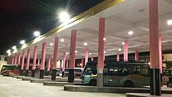
The only State highway passes through Gangarampur is [[State Highway 10 (West Bengal)]]. The state highway has recently been upgraded into [[National Highway 512 (India)]] by Government of India.<ref>{{cite web|url=http://morth.nic.in/showfile.asp?lid=366|title=State wise Length of National Highways in India - Ministry of Road Transport & Highways, Government of India|website=morth.nic.in|access-date=15 August 2017|archive-url=https://archive. | The only State highway passes through Gangarampur is [[State Highway 10 (West Bengal)]]. The state highway has recently been upgraded into [[National Highway 512 (India)]] by Government of India.<ref>{{cite web|url=http://morth.nic.in/showfile.asp?lid=366|title=State wise Length of National Highways in India - Ministry of Road Transport & Highways, Government of India|website=morth.nic.in|access-date=15 August 2017|archive-url=https://archive.today/20121022105130/http://www.morth.nic.in/showfile.asp?lid=366|archive-date=22 October 2012|url-status=dead|df=dmy-all}}</ref> This highway connects Gangarampur with [[National Highway 12 (India)]], which is the only other National Highway in [[Dakshin Dinajpur]]. This newly upgraded 96 kilometers long National Highway is stretched from [[Gajol, West Bengal|Gazole]] to Hilli (near Indo/Bangladesh). Both private and public night bus services to [[Kolkata]], [[Siliguri]], [[Jalpaiguri]], [[Cooch Behar]] are available. Buses to [[Balurghat]], [[Raiganj]] and [[English Bazar|Malda]] run frequently throughout the day. Recently the [[Gangarampur Bus Stand|New Bus Terminal]] near the old one was inaugurated. | ||
[[File:Gangarampur New Bus Terminal.jpg|thumb|Gangarampur New Bus Terminal]] | [[File:Gangarampur New Bus Terminal.jpg|thumb|Gangarampur New Bus Terminal]] | ||
| Line 219: | Line 208: | ||
===Train=== | ===Train=== | ||
{{see also|Gangarampur railway station}} | {{see also|Gangarampur railway station}} | ||
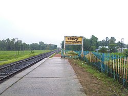
[[Gangarampur Railway Station]] was built earlier in 2004 and the first train ran on 30 December 2004. The station is located at the south side of the city near [[Gangarampur College]]. Few express trains like [[Howrah–Balurghat | [[Gangarampur Railway Station]] was built earlier in 2004 and the first train ran on 30 December 2004. The station is located at the south side of the city near [[Gangarampur College]]. Few express trains like [[Howrah–Balurghat Express]], [[Tebhaga Express(Balurghat-Kolkata)]], [[Gour Express(Balurghat-Sealdah)]], [[Balurghat-Siliguri Intercity Express]] stops at [[Gangarampur Railway Station]]. | ||
[[File:Gangarampur Railway Station.jpeg|thumb|[[Gangarampur railway station]]]] | [[File:Gangarampur Railway Station.jpeg|thumb|[[Gangarampur railway station]]]] | ||
==Health== | ==Health== | ||
The subdivisional hospital is located at the eastern side of the city near [[Kaldighi]]. The hospital runs with 250 beds. For improvement of overall health care services in [[Dakshin Dinajpur district]] many intervention-specific projects/programmes like improvement of infrastructural facilities in the secondary level hospitals, reducing the prevalence of Malaria, creating awareness about HIV, to look after the reproductive and child health of the below poverty line people in the municipal areas, providing free treatment/medicine to them etc. are taken under consideration.<ref>{{cite web|url=http://www.ddinajpur.nic.in/Health_Centres/health_centres.html|title=Health Centres|website=www.ddinajpur.nic.in}}</ref> [[Gangarampur Super Speciality Hospital]] is now #2 Hospital in [[Dakshin Dinajpur district]]. Balurghat superspeciality hospital has 10 floor.#1. Balurghat district hospital is just 35 km from Gangarampur. Gangarampur Ghosh Medical Hall & Ghosh Sonoscan Centre is one of best & | The subdivisional hospital is located at the eastern side of the city near [[Kaldighi]]. The hospital runs with 250 beds. For improvement of overall health care services in [[Dakshin Dinajpur district]] many intervention-specific projects/programmes like improvement of infrastructural facilities in the secondary level hospitals, reducing the prevalence of Malaria, creating awareness about HIV, to look after the reproductive and child health of the below poverty line people in the municipal areas, providing free treatment/medicine to them etc. are taken under consideration.<ref>{{cite web|url=http://www.ddinajpur.nic.in/Health_Centres/health_centres.html|title=Health Centres|website=www.ddinajpur.nic.in|access-date=15 August 2017|archive-date=27 August 2017|archive-url=https://web.archive.org/web/20170827005054/http://www.ddinajpur.nic.in/Health_Centres/health_centres.html|url-status=dead}}</ref> [[Gangarampur Super Speciality Hospital]] is now #2 Hospital in [[Dakshin Dinajpur district]]. Balurghat superspeciality hospital has 10 floor.#1. Balurghat district hospital is just 35 km from Gangarampur. Gangarampur [[Ghosh Medical Hall & Ghosh Sonoscan Centre]] is one of the best & reputed pharmaceutical store & leading healthcare centre among the whole district. | ||
==Sports== | ==Sports== | ||
| Line 234: | Line 220: | ||
The favourite sports in Gangarampur are cricket and football like other parts of West Bengal. As in the rest of India, cricket is popular in Gangarampur and is played on grounds and in streets throughout the city. The Football Club ground, a vast field that serves as the city's largest park, hosts several minor football and cricket games. | The favourite sports in Gangarampur are cricket and football like other parts of West Bengal. As in the rest of India, cricket is popular in Gangarampur and is played on grounds and in streets throughout the city. The Football Club ground, a vast field that serves as the city's largest park, hosts several minor football and cricket games. | ||
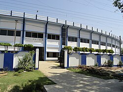
[[Gangarampur Stadium]] is located by the | [[Gangarampur Stadium]] is located by the national highway (NH 512) near [[Kaldighi]]. The stadium was built in early twenty first century. | ||
[[File:Gangarampur Stadium.JPG|left|thumb|300x200px|Gangarampur Stadium]]Balurghat DSA is just 35 km from gangarampur | [[File:Gangarampur Stadium.JPG|left|thumb|300x200px|Gangarampur Stadium]]Balurghat DSA is just 35 km from gangarampur | ||
| Line 245: | Line 231: | ||
===Bangarh=== | ===Bangarh=== | ||
{{main|Bangarh}} | {{main|Bangarh}} | ||
Bangarh is the site of an archaeological dig, where work commenced in 1938 on uncovering remains of structures dating from the pre-[[Maurya Empire]] (326 BCE–180 BCE) to the [[Pala Empire]] (8th to 12th century).<ref>{{cite web|title=Eight eras of Indian history unearthed in Bangarh|url=https://www.telegraphindia.com/1090514/jsp/siliguri/story_10954127.jsp|publisher=The Telegraph|access-date=15 August 2017|date=14 May 2009}}</ref> | Bangarh is the site of an archaeological dig, where work commenced in 1938 on uncovering remains of structures dating from the pre-[[Maurya Empire]] (326 BCE–180 BCE) to the [[Pala Empire]] (8th to 12th century).<ref>{{cite web|title=Eight eras of Indian history unearthed in Bangarh|url=https://www.telegraphindia.com/1090514/jsp/siliguri/story_10954127.jsp|archive-url=https://web.archive.org/web/20121023163514/http://www.telegraphindia.com/1090514/jsp/siliguri/story_10954127.jsp|url-status=dead|archive-date=23 October 2012|publisher=The Telegraph|access-date=15 August 2017|date=14 May 2009}}</ref> | ||
===Kaldighi=== | ===Kaldighi=== | ||
Kaldighi Lake and Dhaldighi Lake, located at the east side of the city, are home to migratory birds and freshwater fish. The lakes are a tourist attraction as well as a source of revenue for local fishermen.<ref>{{cite web|url=http://www.ddinajpur.nic.in/Dm_Desk/dm_desk.html|title=DM's DESK|website=www.ddinajpur.nic.in}}</ref> | Kaldighi Lake and Dhaldighi Lake, located at the east side of the city, are home to migratory birds and freshwater fish. The lakes are a tourist attraction as well as a source of revenue for local fishermen.<ref>{{cite web|url=http://www.ddinajpur.nic.in/Dm_Desk/dm_desk.html|title=DM's DESK|website=www.ddinajpur.nic.in|access-date=15 August 2017|archive-date=10 December 2017|archive-url=https://web.archive.org/web/20171210084121/http://www.ddinajpur.nic.in/Dm_Desk/dm_desk.html|url-status=dead}}</ref> | ||
[[File:Fishermen catching fish in Kaldighi.jpg|thumb|Fishermen catching fish in Kaldighi]] | [[File:Fishermen catching fish in Kaldighi.jpg|thumb|Fishermen catching fish in Kaldighi]] | ||
| Line 254: | Line 240: | ||
{{Main|Dargah of Shah Ata}} | {{Main|Dargah of Shah Ata}} | ||
The building was probably constructed in the 14th century | The building was probably constructed in the 14th century. The building is a brick and stone mausoleum, the burial site of Mollah Atar-Uddin or Shah Ata.<ref>{{cite web |url=http://www.asikolkata.in/dinajpur.aspx |publisher=ASI, Kolkata Circle |title=History of Dargah of Shah Ata}}</ref> | ||
===Parks=== | ===Parks=== | ||
| Line 260: | Line 246: | ||
[[File:Kalitala Children Park by Nayan Halder.jpg|thumb|right|Kalitala Children Park, Gangarampur]] | [[File:Kalitala Children Park by Nayan Halder.jpg|thumb|right|Kalitala Children Park, Gangarampur]] | ||
The first of these, Kalitala Children Park ({{ | The first of these, Kalitala Children Park ({{langx|bn|কালিতলা শিশু উদ্যান)}} is owned by Gangarampur Municipality,<ref>{{cite web |url=https://yellowpages.cybo.com/IN-biz/kalitala-children-park|title=Kalitala Children Park |publisher=Cybo|access-date=2017-08-16}}</ref> and is located at [[National Highway 512 (India)|National Highway 512]] and adjacent with [[Punarbhaba River]] in Gangarampur city. | ||
===Movie theater=== | ===Movie theater=== | ||
| Line 285: | Line 271: | ||
[[Category:Cities and towns in Dakshin Dinajpur district]] | [[Category:Cities and towns in Dakshin Dinajpur district]] | ||
[[Category:Dakshin Dinajpur district]] | [[Category:Dakshin Dinajpur district]] | ||
[[Category:Cities in West Bengal]] | |||
Latest revision as of 18:08, 27 April 2026
Gangarampur | |
|---|---|
City | |
Gangarampur is located in West Bengal  Gangarampur Location in West Bengal, India  Gangarampur Gangarampur (India) | |
| Coordinates: 25°24′N 88°31′E / 25.4°N 88.52°E | |
| Country |  India India |
| State | West Bengal |
| District | Dakshin Dinajpur |
| Government | |
| • Type | Municipality |
| • Body | Gangarampur Municipality |
| • Chairman | Prasanta Mitra |
| • Member of Legislative Assembly | Satyendra Nath Ray |
| • Member of Parliament | Sukanta Majumdar, Union Minister of State for MoE and MoDoNER |
| Area | |
| • Total | 10.29 km2 (3.97 sq mi) |
| Elevation | 25 m (82 ft) |
| Population (2011) | |
| • Total | 56,175 |
| • Density | 5,500/km2 (14,000/sq mi) |
| Languages | |
| • Official | Bengali, English |
| Time zone | UTC+5:30 (IST) |
| PIN | 733124 |
| Telephone code | 03521 |
| Vehicle registration | WB61 - WB62 |
| Lok Sabha constituency | Balurghat |
| Vidhan Sabha constituency | Gangarampur |
| Website | www |

Gangarampur is one of the cities and a municipality in Dakshin Dinajpur district in the state of West Bengal, India. Balurghat is the headquarters of the Gangarampur Subdivision. The city is located on the bank of river Punarbhaba. Gangarampur is one of the major cities connected through National Highway 512. It became the subdivision of newly formed district Dakshin Dinajpur when Paschim Dinajpur was bifurcated into Uttar and Dakshin Dinajpur in 1992. It was one of the Khalji capital under Muhammad Khalji.[2]
Geography[edit | edit source]
Lua error in Module:OSM_Location_map at line 1984: attempt to index field 'wikibase' (a nil value).
Location[edit | edit source]
Gangarampur is located almost in the middle of Dakshin Dinajpur district at 25°24′N 88°31′E / 25.4°N 88.52°E.[3] It has spread linearly along the banks of the Punarbhaba River.[4] It has an average elevation of 25 metres (82 feet). The area of the city is 10.29 Sq. km.[1]
In the map alongside, all places marked on the map are linked in the full screen version.
Climate[edit | edit source]
Gangarampur has a Tropical wet-and-dry climate, with summer monsoons. The maximum temperatures can often exceed 38 °C (100 °F) during May–June. Winter tends to last from December to early-February, with the lowest temperatures hovering in the 4 °C (40 °F) to 8 °C (47 °F) range during December and January. Monsoon is the most notable phenomenon in the climate of the city. Maximum rainfall occurs during the monsoon in July–August.
| Climate data for Gangarampur, India | |||||||||||||
|---|---|---|---|---|---|---|---|---|---|---|---|---|---|
| Month | Jan | Feb | Mar | Apr | May | Jun | Jul | Aug | Sep | Oct | Nov | Dec | Year |
| Average high °C (°F) | 24 (76) |
28 (82) |
33 (92) |
37 (98) |
36 (97) |
34 (94) |
33 (91) |
32 (90) |
33 (91) |
32 (89) |
29 (84) |
26 (79) |
32 (89) |
| Average low °C (°F) | 11 (52) |
13 (56) |
18 (64) |
22 (72) |
24 (76) |
26 (78) |
26 (79) |
26 (78) |
26 (78) |
23 (73) |
17 (63) |
13 (55) |
20 (68) |
| Average precipitation mm (inches) | 13 (0.5) |
10 (0.4) |
15 (0.6) |
43 (1.7) |
120 (4.8) |
520 (20.3) |
620 (24.4) |
560 (22.2) |
240 (9.5) |
99 (3.9) |
10 (0.4) |
2.5 (0.1) |
2,260 (88.8) |
| Source: Weatherbase[5] | |||||||||||||
Demographics[edit | edit source]
As of 2011[update] India census,[6] Gangarampur had a population of 56,175. Males constitute 52% of the population and females 48%. Gangarampur has an average literacy rate of 77%, higher than the national average of 74%: male literacy is 84%, and female literacy is 70%. In Gangarampur, 13% of the population is under 6 years of age.
Historic population
| 1991 | 31,177 |
| 2001 | 53,533 |
| 2011 | 56,175 |
Education[edit | edit source]
Colleges[edit | edit source]
There are many colleges in the city limits:
 | This article contains embedded lists that may be poorly defined, unverified or indiscriminate. (April 2026) |
Schools[edit | edit source]
There are many public and private schools in the city limits:
| This article contains embedded lists that may be poorly defined, unverified or indiscriminate. (April 2026) |
- Chittaranjan English Medium School
- Gangarampur Girls' High School
- Gangarampur High School[8]
- Holy Cross Primary School
- Holy Cross Girls High School
- Indranarayanpur Colony High School
- Jamir Smriti Public Mission School
- Kabitirtha Bangla Academy
- Kalitala Vidyasagar Shishu Niketan
- Kids Hall
- Niranjan Ghosh Smriti Vidyapith
- Orient National School
- Promod Dasgupta Smrity Vidyapith
- Rabrindra Smriti Vidyapith
- St. Joseph High School
- St. Pauls School
- Samput School of Classical Dance
- Saraswati Shishu Mandir, Gangarampur
- Shemrock Disha Play School
- Ujjwal Kids World
Economy[edit | edit source]
The economy of Gangarampur is driven by agricultural farming, small business, handloom and handloom based handicrafts. Important handloom potential areas are located in Boaldaha, Korial, Belberi-I, Belberi-II and various parts in Gangarampur Municipality area. Important handloom products include cotton ordinary saree, cotton Mala saree, ladies churidar set (churidars are tightly fitting trousers worn by both men and women in South Asia), gents kurta/panjabi and Shirting Than (Length of cloth) etc. According to the annual report published by Directorate of Textiles (Govt. of West Bengal) Bordangi (located near Gangarampur College) area has 588, where as rest of Gangarampur area has 252 looms.[9]
Transportation[edit | edit source]
Gangarampur is connected to Kolkata, Siliguri, Jalpaiguri, Malda, Balurghat, Kishanganj, Cooch Behar, Bardhaman, Asansol, Raiganj, Durgapur, Nadia, and other major places in West Bengal and Bihar by both bus and train services.
Bus[edit | edit source]
The only State highway passes through Gangarampur is State Highway 10 (West Bengal). The state highway has recently been upgraded into National Highway 512 (India) by Government of India.[10] This highway connects Gangarampur with National Highway 12 (India), which is the only other National Highway in Dakshin Dinajpur. This newly upgraded 96 kilometers long National Highway is stretched from Gazole to Hilli (near Indo/Bangladesh). Both private and public night bus services to Kolkata, Siliguri, Jalpaiguri, Cooch Behar are available. Buses to Balurghat, Raiganj and Malda run frequently throughout the day. Recently the New Bus Terminal near the old one was inaugurated.

Train[edit | edit source]
Gangarampur Railway Station was built earlier in 2004 and the first train ran on 30 December 2004. The station is located at the south side of the city near Gangarampur College. Few express trains like Howrah–Balurghat Express, Tebhaga Express(Balurghat-Kolkata), Gour Express(Balurghat-Sealdah), Balurghat-Siliguri Intercity Express stops at Gangarampur Railway Station.

Health[edit | edit source]
The subdivisional hospital is located at the eastern side of the city near Kaldighi. The hospital runs with 250 beds. For improvement of overall health care services in Dakshin Dinajpur district many intervention-specific projects/programmes like improvement of infrastructural facilities in the secondary level hospitals, reducing the prevalence of Malaria, creating awareness about HIV, to look after the reproductive and child health of the below poverty line people in the municipal areas, providing free treatment/medicine to them etc. are taken under consideration.[11] Gangarampur Super Speciality Hospital is now #2 Hospital in Dakshin Dinajpur district. Balurghat superspeciality hospital has 10 floor.#1. Balurghat district hospital is just 35 km from Gangarampur. Gangarampur Ghosh Medical Hall & Ghosh Sonoscan Centre is one of the best & reputed pharmaceutical store & leading healthcare centre among the whole district.
Sports[edit | edit source]
The favourite sports in Gangarampur are cricket and football like other parts of West Bengal. As in the rest of India, cricket is popular in Gangarampur and is played on grounds and in streets throughout the city. The Football Club ground, a vast field that serves as the city's largest park, hosts several minor football and cricket games.
Gangarampur Stadium is located by the national highway (NH 512) near Kaldighi. The stadium was built in early twenty first century.

Balurghat DSA is just 35 km from gangarampur
Language[edit | edit source]
Bengali is the main language of Gangarampur. The principal communities are Hindus and Muslims, constituting the major portion of the population. There are many temples, mosques and churches around the city for religious practice.
Attractions[edit | edit source]
Bangarh[edit | edit source]
Bangarh is the site of an archaeological dig, where work commenced in 1938 on uncovering remains of structures dating from the pre-Maurya Empire (326 BCE–180 BCE) to the Pala Empire (8th to 12th century).[12]
Kaldighi[edit | edit source]
Kaldighi Lake and Dhaldighi Lake, located at the east side of the city, are home to migratory birds and freshwater fish. The lakes are a tourist attraction as well as a source of revenue for local fishermen.[13]

Dargah of Shah Ata[edit | edit source]
The building was probably constructed in the 14th century. The building is a brick and stone mausoleum, the burial site of Mollah Atar-Uddin or Shah Ata.[14]
Parks[edit | edit source]
There are three main parks in the area, Kalitala Children Park, Kaldighi Park and Gangarampur Shishu Udyan

The first of these, Kalitala Children Park (Bengali: কালিতলা শিশু উদ্যান) is owned by Gangarampur Municipality,[15] and is located at National Highway 512 and adjacent with Punarbhaba River in Gangarampur city.
Movie theater[edit | edit source]
There are two movie theaters showing Bengali and Hindi movies.[citation needed]
See also[edit | edit source]
- Gangarampur College
- Gangarampur Railway Station
- Bangarh
- Gangarampur Government Polytechnic
- Kaldighi
- Gangarampur Stadium
References[edit | edit source]
- ↑ 1.0 1.1 "Gangarampur City".
- ↑ Kerr-Smiley, Mark (2025). Mamluks, Conquest and Culture: The Ghurid Empire and Early Delhi Sultanate c. 1150-1236. Unicorn Publishing Group. p. 68. ISBN 978-1-916846-76-0.
- ↑ "Maps, Weather, and Airports for Gangarampur, India". www.fallingrain.com.
- ↑ "Flood Management, Gangarampur". Dakshin Dinajpur district. Archived from the original on 7 September 2019. Retrieved 19 August 2017.
- ↑ "Balurghat, India Travel Weather Averages (Weatherbase)". www.weatherbase.com. Retrieved 24 June 2014.
- ↑ "Official Web Site of Department of Municipal Affairs, Govt. of West Bengal". www.wbdma.gov.in. Archived from the original on 25 July 2018. Retrieved 15 August 2017.
- ↑ "Gangarampur College, Dakshin Dinajpur, West Bengal, India Reviews". college.globalshiksha.com. Archived from the original on 3 March 2016. Retrieved 15 August 2017.
- ↑ "Institute Overview". Gangarampur Girls' High School. Archived from the original on 19 May 2024.
- ↑ "Directorate of Textiles, Handlooms, Spinning Mills, Silk Weaving & Handloom Based Handicrafts Division". www.westbengalhandloom.org.
- ↑ "State wise Length of National Highways in India - Ministry of Road Transport & Highways, Government of India". morth.nic.in. Retrieved 15 August 2017.
{{cite web}}: CS1 maint: deprecated archival service (link) - ↑ "Health Centres". www.ddinajpur.nic.in. Archived from the original on 27 August 2017. Retrieved 15 August 2017.
- ↑ "Eight eras of Indian history unearthed in Bangarh". The Telegraph. 14 May 2009. Archived from the original on 23 October 2012. Retrieved 15 August 2017.
- ↑ "DM's DESK". www.ddinajpur.nic.in. Archived from the original on 10 December 2017. Retrieved 15 August 2017.
- ↑ "History of Dargah of Shah Ata". ASI, Kolkata Circle.
- ↑ "Kalitala Children Park". Cybo. Retrieved 16 August 2017.