



>Hydrogenation Removed duplicate paragraph |
correct information per standard format per standard format |
||
| Line 1: | Line 1: | ||
{{About|the district|its eponymous headquarters|Boudh}} | {{About|the district|its eponymous headquarters|Boudh}} | ||
{{ | {{Use Indian English|date=November 2021}} | ||
{{Infobox settlement | {{Infobox settlement | ||
| name = Boudh district | | name = Boudh district | ||
| Line 14: | Line 9: | ||
| nickname = | | nickname = | ||
| settlement_type = [[List of districts of Odisha|District]] of [[Odisha]] | | settlement_type = [[List of districts of Odisha|District]] of [[Odisha]] | ||
| image_skyline = Ramnath Temple - Boudh, Orissa, India.jpg | | image_skyline = {{Photomontage | ||
|size = 250 | |||
|photo1a = Ramnath Temple - Boudh, Orissa, India.jpg | |||
|photo2a = Kiakata Bdrige 3.JPG | |||
}} | |||
| image_alt = | | image_alt = | ||
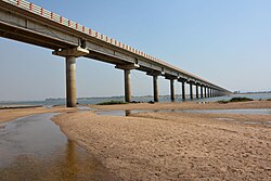
| image_caption = Ramnath Temple, Boudh | | image_caption = Top: Ramnath Temple, [[Boudh]]<br />Bottom: Kiakata Bridge over the [[Mahanadi]] | ||
| | | image_map1 = | ||
| map_alt = | |||
| coordinates = {{coord|20.833|N|84.333|E|display=inline,title}} | | coordinates = {{coord|20.833|N|84.333|E|display=inline,title}} | ||
| map_caption = Location in Odisha, India | | map_caption = Location in Odisha, India | ||
| Line 33: | Line 33: | ||
| governing_body = | | governing_body = | ||
| leader_title = [[District collector|Collector & District Magistrate]] | | leader_title = [[District collector|Collector & District Magistrate]] | ||
| leader_name = | | leader_name = Bibhuti Bhusan Nayak<ref>{{Cite web |title=Who's Who: Boudh |url=https://boudh.odisha.gov.in/about-district/who-s-who |url-status=live |access-date=2025-11-02 |website=Boudh District, Government of Odisha |publisher=[[Government of Odisha]] |language=en-IN}}</ref> | ||
| leader_title1 = | | leader_title1 = Divisional Forest Officer Cum Wildlife Warden | ||
| leader_name1 = | | leader_name1 = Devapriya kampha, OFS | ||
| leader_title2 = [[Superintendent of Police (India)|Superintendent of Police]] | | leader_title2 = [[Superintendent of Police (India)|Superintendent of Police]] | ||
| leader_name2 = | | leader_name2 = Rajprasad IPS, [[Indian Police Service|IPS]] | ||
| unit_pref = Metric | | unit_pref = Metric | ||
| area_footnotes = | | area_footnotes = | ||
| Line 47: | Line 47: | ||
| population_as_of = 2011 | | population_as_of = 2011 | ||
| population_rank = 29 | | population_rank = 29 | ||
| population_density_km2 = | | population_density_km2 = auto | ||
| population_demonym = | | population_demonym = | ||
| population_footnotes = | | population_footnotes = <ref name=districtcensus/> | ||
| demographics_type1 = Languages | | demographics_type1 = Languages | ||
| demographics1_title1 = Official | | demographics1_title1 = Official | ||
| Line 59: | Line 59: | ||
| registration_plate = OD-27 | | registration_plate = OD-27 | ||
| blank1_name_sec1 = Nearest city | | blank1_name_sec1 = Nearest city | ||
| blank1_info_sec1 = [[ | | blank1_info_sec1 = [[Sambalpur]] | ||
| blank2_name_sec1 = [[Human sex ratio|Sex ratio]] | | blank2_name_sec1 = [[Human sex ratio|Sex ratio]] | ||
| blank2_info_sec1 = 991 [[male|♂]]/[[female|♀]] | | blank2_info_sec1 = 991 [[male|♂]]/[[female|♀]] | ||
| Line 73: | Line 73: | ||
| footnotes = | | footnotes = | ||
}} | }} | ||
'''Boudh district''' is an administrative and municipal district, one of [[list of districts of Odisha|thirty]] in [[Odisha]], [[India]]. The district headquarters is located in the city of Boudh. | |||
'''Boudh | |||
==History== | ==History== | ||
{{See also|Boudh State}} | {{See also|Boudh State}} | ||
[[File:Drapeau Baudh.png|thumb|Flag of the [[Boudh State]]]] | [[File:Drapeau Baudh.png|thumb|Flag of the [[Boudh State]].|left]] | ||
The early history of [[Boudh]] is uncertain. | The early history of [[Boudh]] is uncertain. The discovery of Buddhist artifacts in Boudh has led historians to believe thatit was an important center of Buddhism. Inscriptions indicate that during the mid-8th century CE, the Boudh region was a part of Khinjali Mandala and it was under the rule of the Bhanja rulers.<ref name="Patel 1991 p.37 ">{{cite book | last=Patel | first=S.K. | title=Cultural history of early medieval Orissa: Åšulki rule | publisher=Sundeep Prakashan | year=1991 | isbn=978-81-85067-71-1 | url=https://books.google.com/books?id=hhFuAAAAMAAJ | access-date=2019-05-27 | page=37}}</ref><ref name="Donaldson 2001 p. 71">{{cite book | last=Donaldson | first=T.E. | title=Iconography of the Buddhist Sculpture of Orissa: Text | publisher=Indira Gandhi National Centre for the Arts | year=2001 | isbn=978-81-7017-406-6 | url=https://books.google.com/books?id=DbxE8zOuRbUC&pg=PA71 | access-date=2019-05-27 | page=71}}</ref><ref name="Bihar Research Society 1930 p.113-116 ">{{cite book | author=Bihar Research Society | title=The Journal of the Bihar Research Society | issue=v. 16 | year=1930 | url=https://books.google.com/books?id=PVfHAAAAMAAJ | access-date=2019-05-27 | pages=113–116 | ||
}}</ref> | }}</ref> | ||
The earliest known ruler of | The earliest known ruler of the Bhanja dynasty was Nettabhanja, who was an independent ruler of the Dhenkanal region. However, his successors migrated toward the Boudh-Sonepur region and founded Khinjali Mandala. They ruled there as the feudatory of the [[Bhauma-Kara dynasty|Bhauma-Karas]] of Tosali. The name Khinjali Mandala appears for first time in the Sonepur copper plate grant of Satrubhanja Dev. Satrubhanja Dev was the son of Silabhanja Dev, which indicates that Silabhanja Dev founded the Bhanja dynasty at Khinjali Mandala. Dhirtipura was the capital of Khinjali Mandala, which has been identified as present-day Boudh town.<ref name="Soszynski 1948">{{cite web | last=Soszynski | first=Henry | title=BAUDH | website=members.iinet.net.au | date=1948-01-01 | url=http://members.iinet.net.au/~royalty/ips/b/baudh.html | access-date=2019-05-26}}</ref><ref name="Proceedings of the Indian History Congress Vol. 52 (1991), pp. 1026-1029">{{cite journal | journal=Proceedings of the Indian History Congress | volume=52 | pages=1026–1029 | jstor=44142745 | last1=Acharya | first1=Subrata Kumar | title=Identification of Shilabhanjadeva of the Madras Museum Plates of Narendradhavala | year=1991 }}</ref> | ||
Janmeyjaya I (also known as Mahabhabagupta), the [[Somavaṃśī dynasty|Somavamsi]] ruler of South Kosala defeated and killed Ranabhanja Dev, son of Satrubhanja Dev, a ruler | Janmeyjaya I (also known as Mahabhabagupta), the [[Somavaṃśī dynasty|Somavamsi]] ruler of South Kosala, defeated and killed Ranabhanja Dev, son of Satrubhanja Dev, a ruler from the Bhanja family. The Bhanjas were forced out of the Boudh region, which was then renamed to Odra Desa.<ref name="Sahu 1997 p.115-116 ">{{cite book | last=Sahu | first=J.K. | title=Historical Geography of Orissa | publisher=Decent Books | year=1997 | isbn=978-81-86921-00-5 | url=https://books.google.com/books?id=NjhuAAAAMAAJ | access-date=2019-05-27 | pages=115–116}}</ref><ref name="Ahamada 1965 p.5 ">{{cite book | last=Ahamada | first=M. | title=District Census Handbook, Orissa: Sambalpur | publisher=Superintendent, Orissa Government Press | year=1965 | url=https://books.google.com/books?id=9G578yQMf6oC | language=en | access-date=2019-06-04 | page=5}}</ref> | ||
Yayati I | Yayati I, the son of Janmejaya I, succeeded him to the throne and established his capital in Odra-desa at a place called Yayatinagara, which has been identified as the present-day town of Jagati in Boudh District.<ref name="Orissa (India) Senapati Sahu 1971 p. ">{{cite book | author=Orissa (India) | last2=Senapati | first2=N. | last3=Sahu | first3=N.K. | title=Orissa District Gazetteers: Dhenkanal | publisher=Superintendent, Orissa Government Press | series=Gazetteer of India | year=1971 | url=https://archive.org/details/dli.csl.3130 | language=en | access-date=2019-05-31 }}</ref> The Somavansi rulers consequently occupied and migrated toward Utkala, leaving South-Kosala in charge of their representatives. Kosala was eventually lost and occupied by the Chodas and the Kalachuris from the south. The Ganga dynasty fought a protracted war with the Kalachuris for nearly a century to gain control of the Kosala territory. It is inferred from the Chatesvar Inscription (1220 CE) that the war finally ended in favour of the Gangas during the reign of Anangabhima Deva III. Thereafter, Boudh came under the rule of the Ganga dynasty along with Sonepur and it was ruled by the Ganga Administrators.<ref name="Rath 1983 p. ">{{cite book | last=Rath | first=B.K. | title=Cultural history of Orissa, A.D. 855-1110 | publisher=Sundeep Prakashan | year=1983 | url=https://books.google.com/books?id=xhFuAAAAMAAJ | access-date=2019-05-31 }}</ref><ref name="Orissa (India) Senapati Sahu 1971 p.60 ">{{cite book | author=Orissa (India) | last2=Senapati | first2=N. | last3=Sahu | first3=N.K. | title=Orissa District Gazetteers: Dhenkanal | publisher=Superintendent, Orissa Government Press | series=Gazetteer of India | year=1971 | url=https://archive.org/details/dli.csl.3130 | language=en | access-date=2019-05-31 | page=[https://archive.org/details/dli.csl.3130/page/n71 60]}}</ref> | ||
Over the years a Brahmin family | Over the years, a Brahmin family from among the Ganga administrators became quasi-independent and ruled over this territory. Gandhamardan Dev was the last Brahmin ruler of this family. He lacked any natural born successors, he adopted Ananga Bhanja from Bhanja royal family of [[Keonjhar State]], who then adopted the Dev surname of his adoptive parents. Ananga Bhanja subsequently became the ruler after Gandharmardhan Dev, assuming the name Ananga Dev. This laid the foundation for the Bhanja dynasty in Boudh in the early 14th century CE. This dynasty continued to rule over this area till 1948, when the state acceded to and merged with the [[Orissa Province]] after the British withdrawal from India. Their kingdom comprised the modern-day Boudh, Athmallik, and Sonepur areas, with its capital headquarters at Swarnapura (Sonepur). The capital was later moved to Boudh due to the friction with the Chouhan rulers of Patna (Patnagarh in Bolangir District).<ref name="Cobden-Ramsay 2011 p. 136">{{cite book | last=Cobden-Ramsay | first=L.E.B. | title=Feudatory States of Orissa: Bengal District Gazetteers | publisher=Logos Press | year=2011 | isbn=978-81-7268-216-3 | url=https://books.google.com/books?id=Rbye1SEL1KAC&pg=PA136 | access-date=2019-05-26 | page=136}}</ref> | ||
Boudh was a very powerful kingdom during the first half of the 17th century CE | Boudh was a very powerful kingdom during the first half of the 17th century CE, with the territory of Sonepur remaining under its direct administration. During this period, the Chouhan rulers of Sambalpur had already established their supremacy over almost entire western Orissa. The Chouhan ruler of [[Sambalpur]], Balabhadradeva (1605-1630 CE), defeated Siddhabhanja Dev (Siddheswar Dev) of Boudh and forced him to relinquish the Sonepur region. They subsequently made it a separate state in 1640 CE.<ref name="Sahu Mishra Sahu 1981 p.286-287 | ||
">{{cite book | | ">{{cite book | last1=Sahu | first1=N.K. | last2=Mishra | first2=P.K. | last3=Sahu | first3=J.K. | title=History of Orissa | publisher=Nalanola | year=1981 | url=https://books.google.com/books?id=ajduAAAAMAAJ | access-date=2019-05-27 | pages=286–287}}</ref> | ||
In the meantime Orissa was occupied by the Muslims. Details | In the meantime, Orissa was occupied by the Muslims. Details regarding the relationship between the rulers of Boudh and the Muslim subedars in [[Cuttack]] is not known. However, Boudh maintained friendly relations with the emperors of India during both Maratha rule and Mughal or other Muslim rulers. Raja Pratap Dev of Boudh rendered assistance to Mughal troops who were passing through Boudh to Puri. Due to this assistance, he was conferred the title "Swasti Sri Derlakhya Dhumbadhipati Jharkhund Mandaleswar". This title continued to be used by the rulers of Boudh till the time of Raja Banamali Deb.<ref name="Lethbridge 2005 p.88">{{cite book | last=Lethbridge | first=R. | title=The Golden Book of India: A Genealogical and Biographical Dictionary of the Ruling Princes, Chiefs, Nobles, and Other Personages, Titled Or Decorated of the Indian Empire | publisher=Aakar Books | year=2005 | isbn=978-81-87879-54-1 | url=https://books.google.com/books?id=7iOsNUZ2MXgC | access-date=2019-05-27 | page=88}}</ref> | ||
Boudh | During the region of Sidhabhanja Dev, also known as Siddheswar Dev, the Sonepur region was conquered from Boudh by the Chouhan ruler of Sambalpur. Boudh state had previously lost territory to other kingdoms as well. In 1498-99 CE, the then Raja of Boudh state gifted the territory of Dasapalla to his younger brother, Narayan Dev. Narayan Dev later asserted his independence from Boudh and made Dasapalla a separate state. In 1599-1600 CE, Raja Madan Mohan Dev ceded the territory lying between Amaimuhan and the Kharang river in the west as dowry to his daughters, who married into the Chouhan royal family of Patna State. [[Athmallik State|Athmallik]] and Khondhmal remained a part of Boudh state for some time.<ref name="Cobden-Ramsay 2011 p. 135">{{cite book | last=Cobden-Ramsay | first=L.E.B. | title=Feudatory States of Orissa: Bengal District Gazetteers | publisher=Logos Press | year=2011 | isbn=978-81-7268-216-3 | url=https://books.google.com/books?id=Rbye1SEL1KAC&pg=PA135 | access-date=2019-05-26 | page=135}}</ref> | ||
After the British conquest of Orissa in 1803 CE, Raja Biswambar Dev of Boudh accepted British sovereignty and entered into a treaty agreement with the [[British East India Company]] on 3 March 1804.<ref name="Cobden-Ramsay 2011 p. 135" /> | |||
After the [[Third Anglo-Maratha War]], the British Government permanently occupied Boudh from the Marathas and included this state in the South West Frontier Agency till 1837, when it was brought under the superintendent of Tributary Mahals, Cuttack.<ref name="Cobden-Ramsay 2011 p. 135" /> | |||
In 1817 CE, Raja Biswambar Dev died and was succeeded by his son Chandra Sekhar Dev. In 1821, Chandra Sekhar Dev received a fresh Sanand from the British Government, fixing the annual tribute at Rs. 800. After his death, his son Pitambara Dev ascended the throne in 1839 CE. During his reign, there was an uprising in the Khondmal region of Ganjam District, led by Chakra Bisoyi. The cause of uprising was the practice of human sacrifice by the Khond tribe of Ganjam District. Pitambara Dev could not quell this uprising, and on 15 February 1855 CE, Khondmal of Ganjam was separated from the Boudh state and annexed to the British territory. Raja Pitambar Dev remained loyal to the British Government and cooperated with the British administration in eradicating human sacrifice and suppressing the Khondh rebellion in Ghumsur and Khondhmal of the then Ganjam District. Chakra Bisoi of Ganjam District, who had stayed in Boudh State since 1855 and organized the Khondhas, was finally driven out of the state, restoring peace and order. The British Government recognized Pitambar Dev's title Raja, by a separate Sanand granted to him in 1875 CE.<ref name="Cobden-Ramsay 2011 p. 136" /> | |||
After the | |||
The [[Athmallik]] state was originally part of Boudh state, with the chief of Boudh serving as the Raja of both Boudh and Athmallik. The chief of Athmallik was called a Zamindar and was addressed as a Samanta. In 1875, the chief of Athmallik was officially recognized as a Raja, and Athamallik became a separate state in 1894 CE.<ref name="Cobden-Ramsay 2011 p. 115">{{cite book | last=Cobden-Ramsay | first=L.E.B. | title=Feudatory States of Orissa: Bengal District Gazetteers | publisher=Logos Press | year=2011 | isbn=978-81-7268-216-3 | url=https://books.google.com/books?id=Rbye1SEL1KAC&pg=PA115 | access-date=2019-05-31 | page=115}}</ref> | |||
The [[Athmallik]] state was | |||
Raja Jogindra Dev succeeded his father Raja Pitambar Dev after his death in 1879 . He was progressive ruler | Raja Jogindra Dev succeeded his father Raja Pitambar Dev after his death in 1879. He was progressive ruler who opened schools and introduced English education in the state.<ref name="Dāsa Mohanty 2006 p.86 ">{{cite book | last1=Dāsa | first1=Ś. | last2=Mohanty | first2=M. | title=A Leaf in the Stream: An Autobiography | publisher=Rupantar | year=2006 | isbn=978-81-901759-6-8 | url=https://books.google.com/books?id=YDadAAAAMAAJ | access-date=2019-06-03 | page=86}}</ref> He died in 1913, leaving his minor son Narayan Dev. Hence the [[Court of Wards (India)|Court of Wards]] and the Dewan took over the running of the affairs of the state. Narayan Dev formally took over after his coronation on 31 March 1925. During Narayan Dev's reign, the power and function of the ruler was considerably reduced and it appears that the state was under the de facto rule of the political agent. Raja Narayan Dev suppressed a political agitation in Boudh in 1930-31 and adopted measures to suppress the Prajamandal Movement in 1945. He also developed the modern-day Jagti village (the historical Yayatinagar, the erstwhile Somavamsi Capital) and renamed it Narayan Nagar. He was the last ruler of the Boudh State and on 1 January 1948, the state merged with the Orissa province.<ref name="Vadivelu 1915 p.412 ">{{cite book | last=Vadivelu | first=A. | title=The Ruling Chiefs, Nobles & Zamindars of India | publisher=G.C. Loganadham | issue=v. 1 | year=1915 | url=https://books.google.com/books?id=PeeRRf0EhnIC | access-date=2019-05-31 | page=412}}</ref><ref name="Mohanty 1997 p.1 ">{{cite book | last=Mohanty | first=B. | title=Orissa, a district-wise analysis | publisher=Vidyaratna Press | year=1997 | url=https://books.google.com/books?id=nyNuAAAAMAAJ | access-date=2019-05-31 | page=1}}</ref><ref name="Lethbridge 2005 p.88"/> | ||
Boudh became a sub-division of the newly created | Both Boudh and Kandhamal were part of Ganjam District for some time. Later, Boudh became a sub-division of the newly created Boudh-Kandhamal District when Kandhamal was separated from Ganjam. On 2 January 1994, Boudh became the district headquarters of a separate district named Boudh, which was carved out of the Boudh-Kandhamal District. | ||
==Geography== | ==Geography== | ||
The district lies in central Odisha towards the south of the [[Mahanadi River]], which forms the western and northern boundary of the district. Across the Mahanadi lay the districts of [[Bolangir District|Bolangir]] to the west, [[Subarnapur District|Subarnapur]] to the northwest, and [[Angul District|Angul]] to the northeast. [[Nayagarh District]] lies to the southeast, [[Phulbani District]] to the south, and [[Kalahandi district]] to the southwest. | The district lies in central Odisha towards the south of the [[Mahanadi River]], which forms the western and northern boundary of the district. Across the Mahanadi lay the districts of [[Bolangir District|Bolangir]] to the west, [[Subarnapur District|Subarnapur]] to the northwest, and [[Angul District|Angul]] to the northeast. [[Nayagarh District]] lies to the southeast, [[Phulbani District]] to the south, and [[Kalahandi district]] to the southwest. | ||
| Line 119: | Line 114: | ||
==Transport== | ==Transport== | ||
[[File:Kiakata Bdrige 3.JPG|thumb|Kiakata Bdrige ([[Mahanadi River]])]] | {{Unsourced|section|date=February 2025}}[[File:Kiakata Bdrige 3.JPG|thumb|Kiakata Bdrige ([[Mahanadi River]]).|left]] | ||
Boudh is well connected with road and rail with other district headquarters and the state capital [[Bhubaneswar]]. The distance of Boudh from Bhubaneswar is 240 km. One can come to Boudh via State Highway No. 1 and 14 (via Nayagarh–Charichhak) or can come by National Highway No. 42. (via Angul). Regular train services are available from Bhubaneswar viz. Bhubaneswar –Sambalpur Intercity Express, Hirakud Express, Puri-Sambalpur passenger train. To reach Boudh one has to get down at Rairakhol station. From here one has to travel around 27 km. either by bus or taxi to reach Boudh. The nearest airport is at Jharsuguda. | Boudh is well connected with road and rail with other district headquarters and the state capital [[Bhubaneswar]]. The distance of Boudh from Bhubaneswar is 240 km. One can come to Boudh via State Highway No. 1 and 14 (via Nayagarh–Charichhak) or can come by National Highway No. 42. (via Angul). Regular train services are available from Bhubaneswar viz. Bhubaneswar –Sambalpur Intercity Express, Hirakud Express, Puri-Sambalpur passenger train. To reach Boudh one has to get down at Rairakhol station. From here one has to travel around 27 km. either by bus or taxi to reach Boudh. The nearest airport is at Jharsuguda. | ||
==Demographics== | ==Demographics== | ||
{{historical populations|11=1901|12=1,22,615|13=1911|14=1,38,767|15=1921|16=1,38,149|17=1931|18=1,51,112|19=1941|20=1,65,204|21=1951|22=1,67,713|23=1961|24=1,90,436|25=1971|26=2,27,902|27=1981|28=2,68,366|29=1991|30=3,17,622|31=2001|32=3,73,372|33=2011|34=4,41,162|source=Census of India<ref>[http://www.censusindia.gov.in/2011census/PCA/A2_Data_Table.html Decadal Variation In Population Since 1901]</ref>|align=center}} | |||
According to the [[2011 census of India|2011 census]] Boudh district has a [[Demographics of India|population]] of 441,162,<ref name="districtcensus">{{Cite web |title=District Census Handbook 2011 - Boudh|url=https://censusindia.gov.in/nada/index.php/catalog/922/download/36556/DH_2011_2122_PART_A_DCHB_BAUDH.pdf|website=[[Census of India]]|publisher=[[Registrar General and Census Commissioner of India]]}}</ref> roughly equal to the nation of [[Malta]].<ref name="cia">{{cite web | author = US Directorate of Intelligence | title = Country Comparison:Population | url = https://www.cia.gov/library/publications/the-world-factbook/rankorder/2119rank.html | archive-url = https://web.archive.org/web/20070613004507/https://www.cia.gov/library/publications/the-world-factbook/rankorder/2119rank.html | url-status = dead | archive-date = June 13, 2007 | access-date = 2011-10-01 | quote = Malta 408,333 July 2011 est.}}</ref> This gives it a ranking of 552nd in India (out of a total of [[Districts of India|640]]).<ref name=districtcensus/> The district has a population density of {{convert|142|PD/sqkm|PD/sqmi}}.<ref name=districtcensus/> Its [[Family planning in India|population growth rate]] over the decade 2001-2011 was 17.82%.<ref name=districtcensus/> Baudh has a [[sex ratio]] of 991 [[Women in India|females]] for every 1000 males,<ref name=districtcensus/> and a [[Literacy in India|literacy rate]] of 72.51%. 4.63% of the population lives in urban areas. Scheduled Castes and Scheduled Tribes make up 23.79% and 12.55% of the population respectively.<ref name=districtcensus/> | |||
}}</ref> | |||
=== Religion === | |||
The majority of the people of the district are [[Hinduism in Odisha|Hindu]] (99.32%) and other religions as minority, including [[Muslims|Muslim]] (0.23%), [[Christians]] (0.12%), [[Sikhs|Sikh]] (0.01%) and others (0.33%). As of [[2011 Census of India|2011 census]], the Boudh district has the highest percentage of Hindus in India.<ref name="census2011-religion">{{cite web|title=Table C-01 Population by Religious Community: Odisha|url=https://censusindia.gov.in/nada/index.php/catalog/11387/download/14500/DDW21C-01%20MDDS.XLS|website=Census of India, 2011|publisher=[[Registrar General and Census Commissioner of India]]}}</ref> | |||
=== Languages === | |||
{{Pie chart | {{Pie chart | ||
| thumb = right | |thumb = right | ||
| caption = Languages of Boudh district | |caption = Languages of Boudh district (2011)<ref name="census2011-langreport"/> | ||
| label1 = [[Odia language|Odia]] | |label1 = [[Odia language|Odia]] |value1 = 78.69 |color1 = saddlebrown | ||
| value1 = 78.69 | |label2 = [[Sambalpuri language|Sambalpuri]] |value2 = 20.55 |color2 = yellow | ||
| color1 = | |other= yes|other-color = Grey | ||
| label2 = [[Sambalpuri language|Sambalpuri]] | |||
| value2 = 20.55 | |||
| color2 = | |||
| | |||
| | |||
}} | }} | ||
==Culture== | |||
Boudh is a new district but the civilization of Boudh area is as old as the oldest river valley civilizations of the world. As all civilization started on the banks of the river and the riverine passage was the mode of transport in the days of yore, people of Boudh claimed to be inheritors of rich culture. From 2nd century AD up to a period of one thousand years, Boudh was an important seat of [[ | At the time of the [[2011 Census of India]], 78.69% of the population in the district spoke [[Odia language|Odia]] and 20.55% [[Sambalpuri language|Sambalpuri]] as their first language.<ref name="census2011-langreport">{{cite web |title=Table C-16 Population by Mother Tongue: Odisha|url=https://censusindia.gov.in/nada/index.php/catalog/10217/download/13329/DDW-C16-STMT-MDDS-2100.XLSX|website=Census of India 2011 |publisher=[[Registrar General and Census Commissioner of India]]}}</ref> | ||
== Culture == | |||
{{Unsourced|section|date=February 2025}} | |||
Boudh is a new district but the civilization of Boudh area is as old as the oldest river valley civilizations of the world. As all civilization started on the banks of the river and the riverine passage was the mode of transport in the days of yore, people of Boudh claimed to be inheritors of rich culture. From 2nd century AD up to a period of one thousand years, Boudh was an important seat of [[Jagannath]]ism, i.e. Odia Vaishnavism, [[Shaivism]] and Shakti cult in the country. Boudh is part of Odia Culture. It was highly developed educationally and culturally during the Soma Vanshi period and also during the Gangas and Surya Vanshi period. | |||
===Communal dance=== | ===Communal dance=== | ||
Various types of dances are prevalent in the district. These are usually held during socio-religious functions. An account of some of the major dances is given below. | Various types of dances are prevalent in the district. These are usually held during socio-religious functions. An account of some of the major dances is given below. | ||
{{div col}} | |||
* Karma dance | |||
* [[Danda Nata]] | |||
* Dalkhai dance | |||
{{div col end}} | |||
{{ | |||
[[ | |||
===Fairs and festivals=== | ===Fairs and festivals=== | ||
The Hindus of the district observe a number of festivals all year round. These festivals may broadly be divided into two categories, viz. domestic festivals observed in each household and public festivals and fairs where people congregate in large numbers on some auspicious days. The domestic festivals are confined to worship of family deities, observance of Ekadashi, various {{ | The Hindus of the district observe a number of festivals all year round. These festivals may broadly be divided into two categories, viz. domestic festivals observed in each household and public festivals and fairs where people congregate in large numbers on some auspicious days. The domestic festivals are confined to worship of family deities, observance of Ekadashi, various {{transliteration|or|vratas}}, etc. most of them being guided by phases of the moon. The public festivals are usually religious ceremonies attended by a large number of men, women, and children who come for worship as well as entertainment. An account of some of the important festivals in the district is given below. | ||
{{div col}} | |||
* Chuda Khai Jatra | |||
* Ratha Jatra | |||
* Laxmi Puja | |||
* Nuakhai | |||
* Sivaratri | |||
* Dasahara | |||
* Dola Jatra | |||
* Puajiuntia and Bhaijiuntia | |||
* Ramaleela | |||
* Kailashi Jatra | |||
{{div col end}} | |||
===Recreation=== | ===Recreation=== | ||
| Line 207: | Line 167: | ||
===Tourism=== | ===Tourism=== | ||
Boudh is known for its century-old temples, ancient Buddha statues, and caves. With the spread of Saivism, Vaishnavism and a number of other cults, numerous shrines dedicated to various deities were found in this region | Boudh is known for its century-old temples, ancient Buddha statues, and caves. With the spread of Saivism, Vaishnavism and a number of other cults, numerous shrines dedicated to various deities were found in this region. The notable temples and other tourist attractions includes:[[File:Chari Sambhu Temple.jpg|thumb|[[Chari Sambhu Temple]].]] | ||
{{div col}} | |||
* Buddha Statues | |||
* Ramanath Temple | |||
* Jogindra Villa Palace | |||
* Hanuman Temple | |||
* Chandra Chuda and Matengeswar Temple | |||
* Madan Mohan Temple | |||
* Jagannath Temple | |||
* Debagarh | |||
[[File: | * [[Chari Sambhu Temple]] | ||
* Purunakatak | |||
*Swapnewar Temple | |||
{{div col end}} | |||
===Places of Interest=== | ===Places of Interest=== | ||
[[File:Maa Bhairabi Temple, Purunakatak, Boudh.jpg|thumb|Bhairabi Temple, Purunakatak.]] | |||
* Padmatola Sanctuary | * Padmatola Sanctuary | ||
* Dambarugada Mountains | * Dambarugada Mountains | ||
* Nayakpada Cave (Patali Shrikhetra) | * Nayakpada Cave (Patali Shrikhetra) | ||
* Marjakud Island | * Marjakud Island | ||
Apart from the above places, there are numerous | * Khandikanpa | ||
Apart from the above places, there are numerous tourist attractions in Boudh, including Asurgada, [[Shiva]] temple at Karadi, Sarsara and Baunsuni, Jatasamadhi temple at Balasinga (Temple of Mahima Cult), and Paljhir Dam. | |||
==Legislation== | ==Legislation== | ||
===Vidhan Sabha Constituencies=== | ===Vidhan Sabha Constituencies=== | ||
{{Main|List of constituencies of Odisha Vidhan Sabha}} | {{Main|List of constituencies of Odisha Vidhan Sabha}} | ||
The following are the 2 [[Odisha Legislative Assembly|Vidhan sabha]] constituencies<ref> | The following are the 2 [[Odisha Legislative Assembly|Vidhan sabha]] constituencies<ref>{{Cite report |title=Final Publication of Delimitation Orders – Orissa |date=2006-12-15 |url=http://eci.nic.in/delim/Final_Publications/Orissa/orissa.pdf |issue=NO. 282/OR/2006 |url-status=dead |publisher=[[Election Commission of India]] |language=en-IN |archive-url=https://web.archive.org/web/20160305154017/http://eci.nic.in/delim/Final_Publications/Orissa/orissa.pdf |archive-date=2016-03-05}}</ref><ref>[http://eci.nic.in/delim/paper1to7/Orissa.xls Seats of Odisha] {{webarchive |url=https://web.archive.org/web/20160305013054/http://eci.nic.in/delim/paper1to7/Orissa.xls |date=March 5, 2016 }}</ref> of Boudh district and the elected members of that area are:<ref>{{cite web |url=http://ws.ori.nic.in/ola/mlaprofile/listofmem1.asp |archive-url=https://web.archive.org/web/20070502003512/http://ws.ori.nic.in/ola/mlaprofile/listofmem1.asp |url-status=dead |archive-date=2 May 2007 |title=List of Member in Fourteenth Assembly |work=ws.ori.nic.in |quote=MEMBER NAME |access-date=19 February 2013 }}</ref> | ||
{| class="wikitable sortable" | {| class="wikitable sortable" | ||
| Line 271: | Line 201: | ||
!Constituency | !Constituency | ||
!Reservation | !Reservation | ||
!Member of 16th Assembly | |||
!Member of | |||
![[Political party|Party]] | ![[Political party|Party]] | ||
|- | |- | ||
| Line 278: | Line 207: | ||
|[[Kantamal (Vidhan Sabha constituency)|Kantamal]] | |[[Kantamal (Vidhan Sabha constituency)|Kantamal]] | ||
|None | |None | ||
| | |Kanhai Charan Danga | ||
| bgcolor="#FF7722" | [[Bharatiya Janta Party|<span style="color:white;">BJP</span>]] | |||
| bgcolor="# | |||
|- | |- | ||
!86 | !86 | ||
| [[Boudh (Vidhan Sabha constituency)|Boudh]] | | [[Boudh (Vidhan Sabha constituency)|Boudh]] | ||
|None | |None | ||
| | | Saroj Pradhan | ||
| | | bgcolor="#FF7722" | [[Bharatiya Janta Party|<span style="color:white;">BJP</span>]] | ||
| bgcolor=" | |} | ||
=== Lok Sabha constituency === | |||
{{Main|List of constituencies of the Lok Sabha#Odisha}} | |||
The Boudh district comes in the Lok Sabha constituency of [[Kandhamal (Lok Sabha constituency)|Kandhamal]] and the elected member of that area is:<ref>{{cite web|title=List of Contesting Candidates (Phase-II) (PC)|url=http://www.ceoorissa.nic.in/docs/Election/2019/Form7A/Phase2/List%20of%20Contesting%20Candidates%20%282nd%20Phase-PC%20Wise%29.pdf|website=ceoorissa.nic.in|publisher=Office of the Chief Electoral Officer, Odisha|accessdate=15 April 2019}}</ref> | |||
{| class="wikitable sortable" | |||
!No. | |||
!Constituency | |||
!Reservation | |||
!Member of 18th Lok Sabha | |||
!Party | |||
|- | |||
!13 | |||
|[[Kandhamal (Lok Sabha constituency)|Kandhamal]] | |||
|Unserved | |||
|[[Sukanta Kumar Panigrahi]] | |||
| bgcolor="{{party color|Bharatiya Janta Party}}" |[[Bharatiya Janta Party|<span style="color:white;">BJP</span>]] | |||
|} | |} | ||
==See also== | |||
* [[Boudh]] | |||
*[[Kandhamal (Lok Sabha constituency)]] | |||
==References== | ==References== | ||
| Line 294: | Line 242: | ||
==External links== | ==External links== | ||
* | {{Commons category}} | ||
* {{Official Website|https://boudh.nic.in/}} | |||
{{Geographic location | {{Geographic location | ||
| Line 307: | Line 256: | ||
|Northwest = [[Subarnapur district]] | |Northwest = [[Subarnapur district]] | ||
}} | }} | ||
{{Boudh district}} | {{Boudh district}} | ||
{{Mahanadi Basin}} | {{Mahanadi Basin}} | ||
| Line 316: | Line 264: | ||
[[Category:Boudh district| ]] | [[Category:Boudh district| ]] | ||
[[Category:1994 establishments in Orissa]] | [[Category:1994 establishments in Orissa]] | ||
[[Category:States and territories established in 1994]] | |||
[[Category:Districts of Odisha]] | [[Category:Districts of Odisha]] | ||
Latest revision as of 19:54, 4 March 2026
Boudh district | |
|---|---|
  | |
| Coordinates: 20°49′59″N 84°19′59″E / 20.833°N 84.333°E | |
| Country |  India India |
| State |  Odisha Odisha |
| Established | 2 January 1994 |
| Headquarters | Boudh |
| Government | |
| • Collector & District Magistrate | Bibhuti Bhusan Nayak[1] |
| • Divisional Forest Officer Cum Wildlife Warden | Devapriya kampha, OFS |
| • Superintendent of Police | Rajprasad IPS, IPS |
| Area | |
| • Total | 3,098 km2 (1,196 sq mi) |
| Population (2011)[2] | |
| • Total | 441,162 |
| • Rank | 29 |
| • Density | 140/km2 (370/sq mi) |
| Languages | |
| • Official | Odia, English |
| Time zone | UTC+5:30 (IST) |
| PIN | 762 0xx |
| Vehicle registration | OD-27 |
| Nearest city | Sambalpur |
| Sex ratio | 991 ♂/♀ |
| Literacy | 72.51% |
| Lok Sabha constituency | Kandhamal |
| Vidhan Sabha constituency | 2 |
| Precipitation | 1,623.1 millimetres (63.90 in) |
| Website | boudh |
Boudh district is an administrative and municipal district, one of thirty in Odisha, India. The district headquarters is located in the city of Boudh.
History[edit | edit source]

The early history of Boudh is uncertain. The discovery of Buddhist artifacts in Boudh has led historians to believe thatit was an important center of Buddhism. Inscriptions indicate that during the mid-8th century CE, the Boudh region was a part of Khinjali Mandala and it was under the rule of the Bhanja rulers.[3][4][5]
The earliest known ruler of the Bhanja dynasty was Nettabhanja, who was an independent ruler of the Dhenkanal region. However, his successors migrated toward the Boudh-Sonepur region and founded Khinjali Mandala. They ruled there as the feudatory of the Bhauma-Karas of Tosali. The name Khinjali Mandala appears for first time in the Sonepur copper plate grant of Satrubhanja Dev. Satrubhanja Dev was the son of Silabhanja Dev, which indicates that Silabhanja Dev founded the Bhanja dynasty at Khinjali Mandala. Dhirtipura was the capital of Khinjali Mandala, which has been identified as present-day Boudh town.[6][7]
Janmeyjaya I (also known as Mahabhabagupta), the Somavamsi ruler of South Kosala, defeated and killed Ranabhanja Dev, son of Satrubhanja Dev, a ruler from the Bhanja family. The Bhanjas were forced out of the Boudh region, which was then renamed to Odra Desa.[8][9]
Yayati I, the son of Janmejaya I, succeeded him to the throne and established his capital in Odra-desa at a place called Yayatinagara, which has been identified as the present-day town of Jagati in Boudh District.[10] The Somavansi rulers consequently occupied and migrated toward Utkala, leaving South-Kosala in charge of their representatives. Kosala was eventually lost and occupied by the Chodas and the Kalachuris from the south. The Ganga dynasty fought a protracted war with the Kalachuris for nearly a century to gain control of the Kosala territory. It is inferred from the Chatesvar Inscription (1220 CE) that the war finally ended in favour of the Gangas during the reign of Anangabhima Deva III. Thereafter, Boudh came under the rule of the Ganga dynasty along with Sonepur and it was ruled by the Ganga Administrators.[11][12]
Over the years, a Brahmin family from among the Ganga administrators became quasi-independent and ruled over this territory. Gandhamardan Dev was the last Brahmin ruler of this family. He lacked any natural born successors, he adopted Ananga Bhanja from Bhanja royal family of Keonjhar State, who then adopted the Dev surname of his adoptive parents. Ananga Bhanja subsequently became the ruler after Gandharmardhan Dev, assuming the name Ananga Dev. This laid the foundation for the Bhanja dynasty in Boudh in the early 14th century CE. This dynasty continued to rule over this area till 1948, when the state acceded to and merged with the Orissa Province after the British withdrawal from India. Their kingdom comprised the modern-day Boudh, Athmallik, and Sonepur areas, with its capital headquarters at Swarnapura (Sonepur). The capital was later moved to Boudh due to the friction with the Chouhan rulers of Patna (Patnagarh in Bolangir District).[13]
Boudh was a very powerful kingdom during the first half of the 17th century CE, with the territory of Sonepur remaining under its direct administration. During this period, the Chouhan rulers of Sambalpur had already established their supremacy over almost entire western Orissa. The Chouhan ruler of Sambalpur, Balabhadradeva (1605-1630 CE), defeated Siddhabhanja Dev (Siddheswar Dev) of Boudh and forced him to relinquish the Sonepur region. They subsequently made it a separate state in 1640 CE.[14]
In the meantime, Orissa was occupied by the Muslims. Details regarding the relationship between the rulers of Boudh and the Muslim subedars in Cuttack is not known. However, Boudh maintained friendly relations with the emperors of India during both Maratha rule and Mughal or other Muslim rulers. Raja Pratap Dev of Boudh rendered assistance to Mughal troops who were passing through Boudh to Puri. Due to this assistance, he was conferred the title "Swasti Sri Derlakhya Dhumbadhipati Jharkhund Mandaleswar". This title continued to be used by the rulers of Boudh till the time of Raja Banamali Deb.[15]
During the region of Sidhabhanja Dev, also known as Siddheswar Dev, the Sonepur region was conquered from Boudh by the Chouhan ruler of Sambalpur. Boudh state had previously lost territory to other kingdoms as well. In 1498-99 CE, the then Raja of Boudh state gifted the territory of Dasapalla to his younger brother, Narayan Dev. Narayan Dev later asserted his independence from Boudh and made Dasapalla a separate state. In 1599-1600 CE, Raja Madan Mohan Dev ceded the territory lying between Amaimuhan and the Kharang river in the west as dowry to his daughters, who married into the Chouhan royal family of Patna State. Athmallik and Khondhmal remained a part of Boudh state for some time.[16]
After the British conquest of Orissa in 1803 CE, Raja Biswambar Dev of Boudh accepted British sovereignty and entered into a treaty agreement with the British East India Company on 3 March 1804.[16]
After the Third Anglo-Maratha War, the British Government permanently occupied Boudh from the Marathas and included this state in the South West Frontier Agency till 1837, when it was brought under the superintendent of Tributary Mahals, Cuttack.[16]
In 1817 CE, Raja Biswambar Dev died and was succeeded by his son Chandra Sekhar Dev. In 1821, Chandra Sekhar Dev received a fresh Sanand from the British Government, fixing the annual tribute at Rs. 800. After his death, his son Pitambara Dev ascended the throne in 1839 CE. During his reign, there was an uprising in the Khondmal region of Ganjam District, led by Chakra Bisoyi. The cause of uprising was the practice of human sacrifice by the Khond tribe of Ganjam District. Pitambara Dev could not quell this uprising, and on 15 February 1855 CE, Khondmal of Ganjam was separated from the Boudh state and annexed to the British territory. Raja Pitambar Dev remained loyal to the British Government and cooperated with the British administration in eradicating human sacrifice and suppressing the Khondh rebellion in Ghumsur and Khondhmal of the then Ganjam District. Chakra Bisoi of Ganjam District, who had stayed in Boudh State since 1855 and organized the Khondhas, was finally driven out of the state, restoring peace and order. The British Government recognized Pitambar Dev's title Raja, by a separate Sanand granted to him in 1875 CE.[13]
The Athmallik state was originally part of Boudh state, with the chief of Boudh serving as the Raja of both Boudh and Athmallik. The chief of Athmallik was called a Zamindar and was addressed as a Samanta. In 1875, the chief of Athmallik was officially recognized as a Raja, and Athamallik became a separate state in 1894 CE.[17]
Raja Jogindra Dev succeeded his father Raja Pitambar Dev after his death in 1879. He was progressive ruler who opened schools and introduced English education in the state.[18] He died in 1913, leaving his minor son Narayan Dev. Hence the Court of Wards and the Dewan took over the running of the affairs of the state. Narayan Dev formally took over after his coronation on 31 March 1925. During Narayan Dev's reign, the power and function of the ruler was considerably reduced and it appears that the state was under the de facto rule of the political agent. Raja Narayan Dev suppressed a political agitation in Boudh in 1930-31 and adopted measures to suppress the Prajamandal Movement in 1945. He also developed the modern-day Jagti village (the historical Yayatinagar, the erstwhile Somavamsi Capital) and renamed it Narayan Nagar. He was the last ruler of the Boudh State and on 1 January 1948, the state merged with the Orissa province.[19][20][15]
Both Boudh and Kandhamal were part of Ganjam District for some time. Later, Boudh became a sub-division of the newly created Boudh-Kandhamal District when Kandhamal was separated from Ganjam. On 2 January 1994, Boudh became the district headquarters of a separate district named Boudh, which was carved out of the Boudh-Kandhamal District.
Geography[edit | edit source]
The district lies in central Odisha towards the south of the Mahanadi River, which forms the western and northern boundary of the district. Across the Mahanadi lay the districts of Bolangir to the west, Subarnapur to the northwest, and Angul to the northeast. Nayagarh District lies to the southeast, Phulbani District to the south, and Kalahandi district to the southwest.
Geographically the Boudh district extends from Latitudes 20°.22’ to 20°.50’N and Longitudes 83°.34’ to 84°.49’E. It is bounded by River Mahanadi and Anugul District to the north, Kandhamal District to the south, Nayagarh District to the east and Tel River and Subarnapur District to the west.[21]
Transport[edit | edit source]
 |
Boudh is well connected with road and rail with other district headquarters and the state capital Bhubaneswar. The distance of Boudh from Bhubaneswar is 240 km. One can come to Boudh via State Highway No. 1 and 14 (via Nayagarh–Charichhak) or can come by National Highway No. 42. (via Angul). Regular train services are available from Bhubaneswar viz. Bhubaneswar –Sambalpur Intercity Express, Hirakud Express, Puri-Sambalpur passenger train. To reach Boudh one has to get down at Rairakhol station. From here one has to travel around 27 km. either by bus or taxi to reach Boudh. The nearest airport is at Jharsuguda.
Demographics[edit | edit source]
| Year | Pop. | ±% |
|---|---|---|
| 1901 | 122,615 | — |
| 1911 | 138,767 | +13.2% |
| 1921 | 138,149 | −0.4% |
| 1931 | 151,112 | +9.4% |
| 1941 | 165,204 | +9.3% |
| 1951 | 167,713 | +1.5% |
| 1961 | 190,436 | +13.5% |
| 1971 | 227,902 | +19.7% |
| 1981 | 268,366 | +17.8% |
| 1991 | 317,622 | +18.4% |
| 2001 | 373,372 | +17.6% |
| 2011 | 441,162 | +18.2% |
| Source: Census of India[22] | ||
According to the 2011 census Boudh district has a population of 441,162,[2] roughly equal to the nation of Malta.[23] This gives it a ranking of 552nd in India (out of a total of 640).[2] The district has a population density of 142 inhabitants per square kilometre (370/sq mi).[2] Its population growth rate over the decade 2001-2011 was 17.82%.[2] Baudh has a sex ratio of 991 females for every 1000 males,[2] and a literacy rate of 72.51%. 4.63% of the population lives in urban areas. Scheduled Castes and Scheduled Tribes make up 23.79% and 12.55% of the population respectively.[2]
Religion[edit | edit source]
The majority of the people of the district are Hindu (99.32%) and other religions as minority, including Muslim (0.23%), Christians (0.12%), Sikh (0.01%) and others (0.33%). As of 2011 census, the Boudh district has the highest percentage of Hindus in India.[24]
Languages[edit | edit source]
- Odia (78.7%)
- Sambalpuri (20.6%)
- Other (0.76%)
At the time of the 2011 Census of India, 78.69% of the population in the district spoke Odia and 20.55% Sambalpuri as their first language.[25]
Culture[edit | edit source]
|
Boudh is a new district but the civilization of Boudh area is as old as the oldest river valley civilizations of the world. As all civilization started on the banks of the river and the riverine passage was the mode of transport in the days of yore, people of Boudh claimed to be inheritors of rich culture. From 2nd century AD up to a period of one thousand years, Boudh was an important seat of Jagannathism, i.e. Odia Vaishnavism, Shaivism and Shakti cult in the country. Boudh is part of Odia Culture. It was highly developed educationally and culturally during the Soma Vanshi period and also during the Gangas and Surya Vanshi period.
Communal dance[edit | edit source]
Various types of dances are prevalent in the district. These are usually held during socio-religious functions. An account of some of the major dances is given below.
- Karma dance
- Danda Nata
- Dalkhai dance
Fairs and festivals[edit | edit source]
The Hindus of the district observe a number of festivals all year round. These festivals may broadly be divided into two categories, viz. domestic festivals observed in each household and public festivals and fairs where people congregate in large numbers on some auspicious days. The domestic festivals are confined to worship of family deities, observance of Ekadashi, various vratas, etc. most of them being guided by phases of the moon. The public festivals are usually religious ceremonies attended by a large number of men, women, and children who come for worship as well as entertainment. An account of some of the important festivals in the district is given below.
- Chuda Khai Jatra
- Ratha Jatra
- Laxmi Puja
- Nuakhai
- Sivaratri
- Dasahara
- Dola Jatra
- Puajiuntia and Bhaijiuntia
- Ramaleela
- Kailashi Jatra
Recreation[edit | edit source]
Leisure and recreation are essential for life. People usually gather in the evening at the temple or in a common place where the priest or Puran panda recites and explains from the religious texts like the Bhagabat, the Mahabharat, the Ramayan, the Haribansa, or other Puranas. The singing of Bhajan or kirtan accompanied with musical instruments like khanjani, gini, mrudanga or harmonium is also another popular form of entertainment for the people. Occasionally acrobatic feats, monkey dance, beard dance, and snake charming and magic performed by itinerant professional groups also provide entertainment to the people. In urban areas cinema, opera are a common source of entertainment. Besides this recreational clubs are also functioning in the district.
Tourism[edit | edit source]
Boudh is known for its century-old temples, ancient Buddha statues, and caves. With the spread of Saivism, Vaishnavism and a number of other cults, numerous shrines dedicated to various deities were found in this region. The notable temples and other tourist attractions includes:

- Buddha Statues
- Ramanath Temple
- Jogindra Villa Palace
- Hanuman Temple
- Chandra Chuda and Matengeswar Temple
- Madan Mohan Temple
- Jagannath Temple
- Debagarh
- Chari Sambhu Temple
- Purunakatak
- Swapnewar Temple
Places of Interest[edit | edit source]

- Padmatola Sanctuary
- Dambarugada Mountains
- Nayakpada Cave (Patali Shrikhetra)
- Marjakud Island
- Khandikanpa
Apart from the above places, there are numerous tourist attractions in Boudh, including Asurgada, Shiva temple at Karadi, Sarsara and Baunsuni, Jatasamadhi temple at Balasinga (Temple of Mahima Cult), and Paljhir Dam.
Legislation[edit | edit source]
Vidhan Sabha Constituencies[edit | edit source]
The following are the 2 Vidhan sabha constituencies[26][27] of Boudh district and the elected members of that area are:[28]
| No. | Constituency | Reservation | Member of 16th Assembly | Party |
|---|---|---|---|---|
| 85 | Kantamal | None | Kanhai Charan Danga | BJP |
| 86 | Boudh | None | Saroj Pradhan | BJP |
Lok Sabha constituency[edit | edit source]
The Boudh district comes in the Lok Sabha constituency of Kandhamal and the elected member of that area is:[29]
| No. | Constituency | Reservation | Member of 18th Lok Sabha | Party |
|---|---|---|---|---|
| 13 | Kandhamal | Unserved | Sukanta Kumar Panigrahi | BJP |
See also[edit | edit source]
References[edit | edit source]
- ↑ "Who's Who: Boudh". Boudh District, Government of Odisha. Government of Odisha. Retrieved 2025-11-02.
{{cite web}}: CS1 maint: url-status (link) - ↑ 2.0 2.1 2.2 2.3 2.4 2.5 2.6 "District Census Handbook 2011 - Boudh" (PDF). Census of India. Registrar General and Census Commissioner of India.
- ↑ Patel, S.K. (1991). Cultural history of early medieval Orissa: Åšulki rule. Sundeep Prakashan. p. 37. ISBN 978-81-85067-71-1. Retrieved 2019-05-27.
- ↑ Donaldson, T.E. (2001). Iconography of the Buddhist Sculpture of Orissa: Text. Indira Gandhi National Centre for the Arts. p. 71. ISBN 978-81-7017-406-6. Retrieved 2019-05-27.
- ↑ Bihar Research Society (1930). The Journal of the Bihar Research Society. pp. 113–116. Retrieved 2019-05-27.
- ↑ Soszynski, Henry (1948-01-01). "BAUDH". members.iinet.net.au. Retrieved 2019-05-26.
- ↑ Acharya, Subrata Kumar (1991). "Identification of Shilabhanjadeva of the Madras Museum Plates of Narendradhavala". Proceedings of the Indian History Congress. 52: 1026–1029. JSTOR 44142745.
- ↑ Sahu, J.K. (1997). Historical Geography of Orissa. Decent Books. pp. 115–116. ISBN 978-81-86921-00-5. Retrieved 2019-05-27.
- ↑ Ahamada, M. (1965). District Census Handbook, Orissa: Sambalpur. Superintendent, Orissa Government Press. p. 5. Retrieved 2019-06-04.
- ↑ Orissa (India); Senapati, N.; Sahu, N.K. (1971). Orissa District Gazetteers: Dhenkanal. Gazetteer of India. Superintendent, Orissa Government Press. Retrieved 2019-05-31.
- ↑ Rath, B.K. (1983). Cultural history of Orissa, A.D. 855-1110. Sundeep Prakashan. Retrieved 2019-05-31.
- ↑ Orissa (India); Senapati, N.; Sahu, N.K. (1971). Orissa District Gazetteers: Dhenkanal. Gazetteer of India. Superintendent, Orissa Government Press. p. 60. Retrieved 2019-05-31.
- ↑ 13.0 13.1 Cobden-Ramsay, L.E.B. (2011). Feudatory States of Orissa: Bengal District Gazetteers. Logos Press. p. 136. ISBN 978-81-7268-216-3. Retrieved 2019-05-26.
- ↑ Sahu, N.K.; Mishra, P.K.; Sahu, J.K. (1981). History of Orissa. Nalanola. pp. 286–287. Retrieved 2019-05-27.
- ↑ 15.0 15.1 Lethbridge, R. (2005). The Golden Book of India: A Genealogical and Biographical Dictionary of the Ruling Princes, Chiefs, Nobles, and Other Personages, Titled Or Decorated of the Indian Empire. Aakar Books. p. 88. ISBN 978-81-87879-54-1. Retrieved 2019-05-27.
- ↑ 16.0 16.1 16.2 Cobden-Ramsay, L.E.B. (2011). Feudatory States of Orissa: Bengal District Gazetteers. Logos Press. p. 135. ISBN 978-81-7268-216-3. Retrieved 2019-05-26.
- ↑ Cobden-Ramsay, L.E.B. (2011). Feudatory States of Orissa: Bengal District Gazetteers. Logos Press. p. 115. ISBN 978-81-7268-216-3. Retrieved 2019-05-31.
- ↑ Dāsa, Ś.; Mohanty, M. (2006). A Leaf in the Stream: An Autobiography. Rupantar. p. 86. ISBN 978-81-901759-6-8. Retrieved 2019-06-03.
- ↑ Vadivelu, A. (1915). The Ruling Chiefs, Nobles & Zamindars of India. G.C. Loganadham. p. 412. Retrieved 2019-05-31.
- ↑ Mohanty, B. (1997). Orissa, a district-wise analysis. Vidyaratna Press. p. 1. Retrieved 2019-05-31.
- ↑ "Boudh District, Government of Odisha". About District. 2018-05-20. Retrieved 2019-05-31.
- ↑ Decadal Variation In Population Since 1901
- ↑ US Directorate of Intelligence. "Country Comparison:Population". Archived from the original on June 13, 2007. Retrieved 2011-10-01.
Malta 408,333 July 2011 est.
- ↑ "Table C-01 Population by Religious Community: Odisha". Census of India, 2011. Registrar General and Census Commissioner of India.
- ↑ 25.0 25.1 "Table C-16 Population by Mother Tongue: Odisha". Census of India 2011. Registrar General and Census Commissioner of India.
- ↑ Final Publication of Delimitation Orders – Orissa (PDF) (Report). Election Commission of India. 2006-12-15. Archived from the original (PDF) on 2016-03-05.
- ↑ Seats of Odisha Archived March 5, 2016, at the Wayback Machine
- ↑ "List of Member in Fourteenth Assembly". ws.ori.nic.in. Archived from the original on 2 May 2007. Retrieved 19 February 2013.
MEMBER NAME
- ↑ "List of Contesting Candidates (Phase-II) (PC)" (PDF). ceoorissa.nic.in. Office of the Chief Electoral Officer, Odisha. Retrieved 15 April 2019.
External links[edit | edit source]
Places adjacent to Boudh district | |
|---|---|


