


→References: nav box |
m further updated information after review also for consistency |
||
| Line 1: | Line 1: | ||
[[File:India Gujarat physical.svg|thumb|300px|Physical map of Gujarat]] | {{Short description|none}} <!-- "none" is preferred when the title is sufficiently descriptive; see [[WP:SDNONE]] --> | ||
{{rewrite|date=June 2022}} | |||
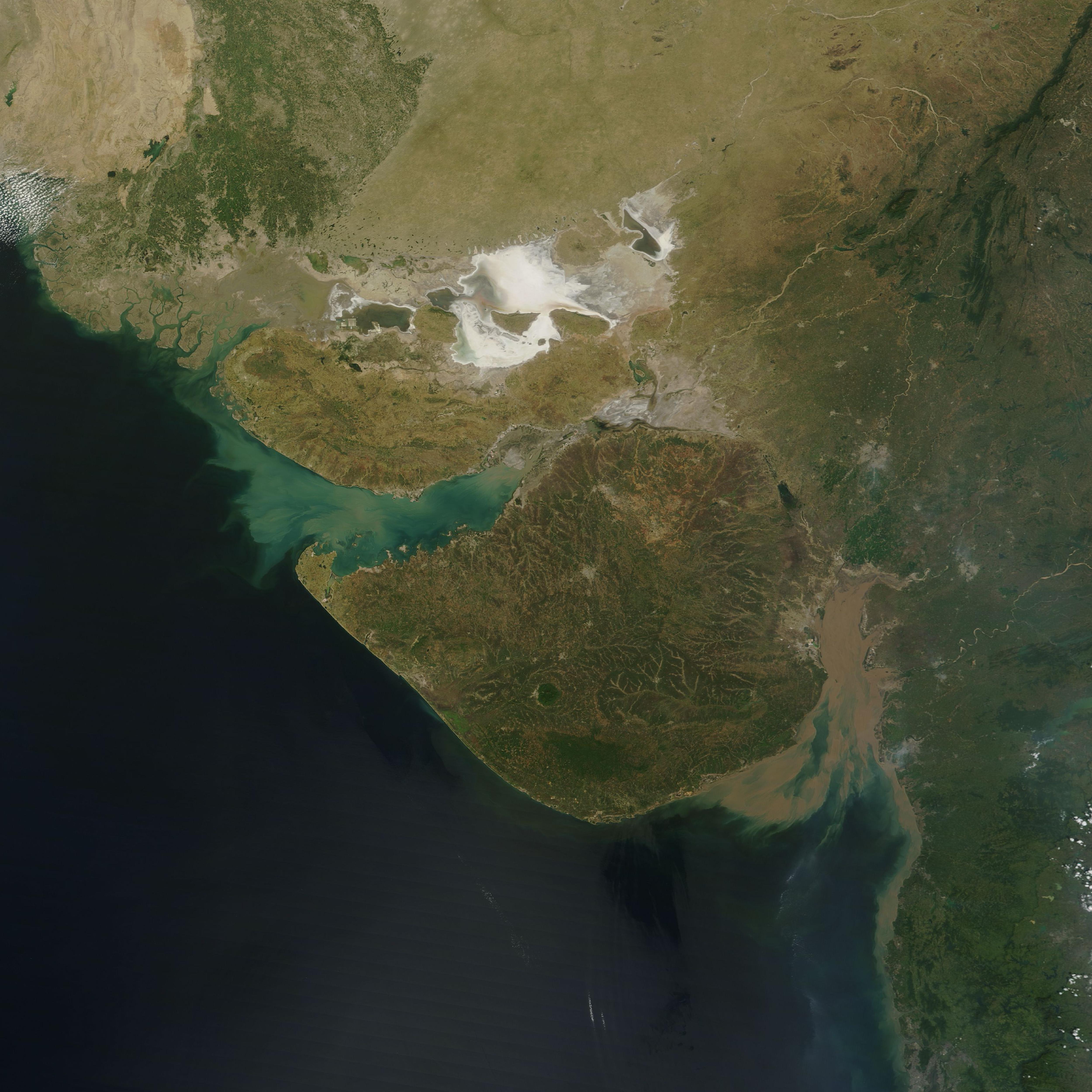
'''Gujarat''' is a [[State (polity)|state]] located in western India. Its north-western border, which is also the international border, is adjacent to [[Pakistan]]. [[Rajasthan]] and [[Madhya Pradesh]] are the states located in its north and north-east respectively. Maharashtra is to its south. The [[Arabian Sea]] forms its western-southern boundary. Dadar and Nagar-Haveli are on its southern border. | |||
The capital of this state is Gandhinagar. Gandhinagar is located near Ahmedabad, the major commercial centre of the state. The area of Gujarat is 196,024 km. | |||
It has the India's longest coastline of 1214 km and also has one of the largest salt deserts in the world with an area of 7500 Sq. km.<ref>{{Cite web |date=2023-10-27 |title=GUJARAT - |url=https://pincodeofmylocation.co.in/india/gujarat/ |access-date=2023-10-28 |language=en-GB}}</ref> | |||
The [[geography]] of [[Gujarat]] state of India includes following:[[File:India Gujarat physical.svg|thumb|300px|Physical map of Gujarat]] | |||
==Mountain ranges== | ==Mountain ranges== | ||
| Line 5: | Line 13: | ||
*[[Western Ghats]] | *[[Western Ghats]] | ||
*[[Satpura range]] | *[[Satpura range]] | ||
*[[ | *[[Tripura hills]] | ||
==Hills== | ==Hills== | ||
| Line 21: | Line 28: | ||
{{Main|List of rivers of Gujarat}} | {{Main|List of rivers of Gujarat}} | ||
*[[Narmada River|Narmada]] | *[[Narmada River|Narmada]] | ||
*[[Tapi River, India| | *[[Tapi River, India|Tapi]] | ||
*[[Mahi River|Mahi]] | *[[Mahi River|Mahi]] | ||
*[[Sabarmati River|Sabarmati]] | *[[Sabarmati River|Sabarmati]] | ||
| Line 35: | Line 42: | ||
==Ecoregions== | ==Ecoregions== | ||
According to the [[World Wide Fund for Nature|WWF]], Gujarat covers portions of five [[terrestrial ecoregion]]s:<ref>Wikramanayake, Eric; Eric Dinerstein; Colby J. Loucks; et al. (2002). ''Terrestrial Ecoregions of the Indo-Pacific: a Conservation Assessment.'' Washington, DC: Island Press.</ref> | According to the [[World Wide Fund for Nature|WWF]], Gujarat covers portions of five [[terrestrial ecoregion]]s:<ref>Wikramanayake, Eric; Eric Dinerstein; Colby J. Loucks; et al. (2002). ''Terrestrial Ecoregions of the Indo-Pacific: a Conservation Assessment.'' Washington, DC: Island Press.</ref> | ||
* The [[Indus River | * The [[Indus River Delta–Arabian Sea mangroves]] are found in tidal areas bordering the [[Gulf of Kutch]] and [[Gulf of Khambat]], as well as in the [[Indus River Delta]] of neighboring [[Sind]] province of Pakistan. | ||
[[File:Rann of Kutch - White Desert.jpg|320x240px|thumbnail|right|Rann of Kutch]] | [[File:Rann of Kutch - White Desert.jpg|320x240px|thumbnail|right|Rann of Kutch]] | ||
* [[ | * [[Khathiar–Gir dry deciduous forests]] cover the eastern portion of the state, extending into adjacent portions of [[Rajasthan]] and [[Madhya Pradesh]], with a pocket on the peak of [[Girnar]] in the central [[Kathiawar]]. The natural vegetation is a [[dry deciduous forest]] with trees up to 25 meters in height, with areas of thorn scrub. The vegetation has been much altered by centuries of intensive agriculture and grazing. | ||
* The [[North Western Ghats moist deciduous forests]] cover the [[Western Ghats]] range in the extreme southeastern portion of Gujarat. The natural vegetation are diverse multistoried rain forests with trees of up to 45 meters in height, along with understory herbs, shrubs and trees, [[liana]]s, and [[ | * The [[North Western Ghats moist deciduous forests]] cover the [[Western Ghats]] range in the extreme southeastern portion of Gujarat. The natural vegetation are diverse multistoried rain forests with trees of up to 45 meters in height, along with understory herbs, shrubs and trees, [[liana]]s, and [[epiphyte]]s. | ||
* [[Northwestern thorn scrub forests]] cover the Kathiawar Peninsula and the upland portion of [[Kutch District]], extending north into Rajasthan. The natural vegetation is open thorn scrub. | * [[Northwestern thorn scrub forests]] cover the Kathiawar Peninsula and the upland portion of [[Kutch District]], extending north into Rajasthan. The natural vegetation is open thorn scrub. | ||
* The [[Rann of Kutch]] is a large seasonal salt marsh in the northwestern portion of Gujarat. | * The [[Rann of Kutch]] is a large seasonal salt marsh in the northwestern portion of Gujarat. | ||
==Beaches== | ==Beaches== | ||
'''[[Umbharat Beach]]''' - [[ | '''[[Umbharat Beach]]''' - [[Jalalpore]] Ubharat Beach is situated on the coastline of the state of Gujarat and is one of the finest beaches of India in [[Navsari District]] of [[Gujarat]] . It comes into Jalalpore Taluka. It is located on the coast of the Gulf of Khambhat, Arabian Sea of Indian Ocean at a distance of 34 km from Jalalpore. and 33 km away from Navsari City, in Navsari District. It is 40 km away from the city of [[Surat]]. | ||
'''[[Dandi Beach]]''' - | '''[[Dandi Beach]]''' - Jalalpore Dandi Beach is situated on the coastline of the state of Gujarat and is one of the finest beaches of India in [[Navsari District]] of [[Gujarat]] . It comes into Jalalpore Taluka. It is located on the coast of the Gulf of Khambhat, Arabian Sea of Indian Ocean at a distance of 15 km from Jalalpore. and 31 km and 22 km away from Bilimora and Navsari City of Navsari District. It is 49 km away from the city of [[Surat]]. | ||
'''[[Ahmedpur Mandvi Beach]]''' - | '''[[Ahmedpur Mandvi Beach]]''' - Ahmedpur Mandvi Beach is situated on the coastline of the state of Gujarat and is one of the finest beaches in India. It is in [[Ahmedpur Mandvi]], close to Diu Union Territory. | ||
'''Mandvi Beach - Kutch''' - Mandvi Wind Farms Beach and Wind-mills, which line the horizon of Mandvi, offer views from the Mandvi sea-beach. The Wind mills projects running in this beach was Asia's 1st Wind-Mills Projects in 1983. | '''Mandvi Beach - Kutch''' - Mandvi Wind Farms Beach and Wind-mills, which line the horizon of Mandvi, offer views from the Mandvi sea-beach. The Wind mills projects running in this beach was Asia's 1st Wind-Mills Projects in 1983. | ||
| Line 53: | Line 60: | ||
'''Chorwad Beach''' - [[Chorwad]] Beach of Gujarat is another beach situated on the west coast of India. It is situated at a distance of 66 km from Junagadh. Chorwad has a high potential of attracting both domestic as well as international tourists.{{citation needed|date=May 2018}} The beach consists of rocky hills and presents an opportunity for boat rides. | '''Chorwad Beach''' - [[Chorwad]] Beach of Gujarat is another beach situated on the west coast of India. It is situated at a distance of 66 km from Junagadh. Chorwad has a high potential of attracting both domestic as well as international tourists.{{citation needed|date=May 2018}} The beach consists of rocky hills and presents an opportunity for boat rides. | ||
'''Diu Beach''' - [[Diu, India|Diu]] beach is situated off the Saurashtra coast and is connected to the | '''Diu Beach''' - [[Diu, India|Diu]] beach is situated on the island of Diu, off the Saurashtra coast Diu has a small population, and is connected to the mainland of Gujarat via a causeway. | ||
'''Gopnath Beach''' - [[Gopnath]] Beach is situated in the Bhavnagar district of Gujarat. It comes into Talaja Taluka. It is located on the coast of the Gulf of Kambhat, at a distance of 75 km from the city of Bhavnagar. and 22 km. away from Talaja. The Fort of the King of Gohilvad is situated in Gopnath. | '''Gopnath Beach''' - [[Gopnath]] Beach is situated in the Bhavnagar district of Gujarat. It comes into Talaja Taluka. It is located on the coast of the Gulf of Kambhat, at a distance of 75 km from the city of Bhavnagar. and 22 km. away from Talaja. The Fort of the King of Gohilvad is situated in Gopnath. | ||
| Line 63: | Line 70: | ||
Umargam is situated on the southern bank of Nargol creek. It was a small village about two centuries ago, serving as a transit point for exporting marine produce from the fishing port Nargol on the Northern Bank of the creek. | Umargam is situated on the southern bank of Nargol creek. It was a small village about two centuries ago, serving as a transit point for exporting marine produce from the fishing port Nargol on the Northern Bank of the creek. | ||
'''Madhavpur Beach''' - [[Madhavpur Ghed]] Beach is on Porbandar-Veraval Highway and residing in Porbadar | '''Madhavpur Beach''' - [[Madhavpur Ghed]] Beach is on Porbandar-Veraval Highway and residing in Porbadar. | ||
==References== | ==References== | ||
Latest revision as of 00:58, 16 May 2025
 | This article may need to be rewritten to comply with Bharatpedia's quality standards. (June 2022) |
Gujarat is a state located in western India. Its north-western border, which is also the international border, is adjacent to Pakistan. Rajasthan and Madhya Pradesh are the states located in its north and north-east respectively. Maharashtra is to its south. The Arabian Sea forms its western-southern boundary. Dadar and Nagar-Haveli are on its southern border.
The capital of this state is Gandhinagar. Gandhinagar is located near Ahmedabad, the major commercial centre of the state. The area of Gujarat is 196,024 km.
It has the India's longest coastline of 1214 km and also has one of the largest salt deserts in the world with an area of 7500 Sq. km.[1]
The geography of Gujarat state of India includes following:

Mountain ranges[edit | edit source]
Hills[edit | edit source]

Rivers[edit | edit source]
Ecoregions[edit | edit source]
According to the WWF, Gujarat covers portions of five terrestrial ecoregions:[2]
- The Indus River Delta–Arabian Sea mangroves are found in tidal areas bordering the Gulf of Kutch and Gulf of Khambat, as well as in the Indus River Delta of neighboring Sind province of Pakistan.

- Khathiar–Gir dry deciduous forests cover the eastern portion of the state, extending into adjacent portions of Rajasthan and Madhya Pradesh, with a pocket on the peak of Girnar in the central Kathiawar. The natural vegetation is a dry deciduous forest with trees up to 25 meters in height, with areas of thorn scrub. The vegetation has been much altered by centuries of intensive agriculture and grazing.
- The North Western Ghats moist deciduous forests cover the Western Ghats range in the extreme southeastern portion of Gujarat. The natural vegetation are diverse multistoried rain forests with trees of up to 45 meters in height, along with understory herbs, shrubs and trees, lianas, and epiphytes.
- Northwestern thorn scrub forests cover the Kathiawar Peninsula and the upland portion of Kutch District, extending north into Rajasthan. The natural vegetation is open thorn scrub.
- The Rann of Kutch is a large seasonal salt marsh in the northwestern portion of Gujarat.
Beaches[edit | edit source]
Umbharat Beach - Jalalpore Ubharat Beach is situated on the coastline of the state of Gujarat and is one of the finest beaches of India in Navsari District of Gujarat . It comes into Jalalpore Taluka. It is located on the coast of the Gulf of Khambhat, Arabian Sea of Indian Ocean at a distance of 34 km from Jalalpore. and 33 km away from Navsari City, in Navsari District. It is 40 km away from the city of Surat.
Dandi Beach - Jalalpore Dandi Beach is situated on the coastline of the state of Gujarat and is one of the finest beaches of India in Navsari District of Gujarat . It comes into Jalalpore Taluka. It is located on the coast of the Gulf of Khambhat, Arabian Sea of Indian Ocean at a distance of 15 km from Jalalpore. and 31 km and 22 km away from Bilimora and Navsari City of Navsari District. It is 49 km away from the city of Surat.
Ahmedpur Mandvi Beach - Ahmedpur Mandvi Beach is situated on the coastline of the state of Gujarat and is one of the finest beaches in India. It is in Ahmedpur Mandvi, close to Diu Union Territory.
Mandvi Beach - Kutch - Mandvi Wind Farms Beach and Wind-mills, which line the horizon of Mandvi, offer views from the Mandvi sea-beach. The Wind mills projects running in this beach was Asia's 1st Wind-Mills Projects in 1983.

Chorwad Beach - Chorwad Beach of Gujarat is another beach situated on the west coast of India. It is situated at a distance of 66 km from Junagadh. Chorwad has a high potential of attracting both domestic as well as international tourists.[citation needed] The beach consists of rocky hills and presents an opportunity for boat rides.
Diu Beach - Diu beach is situated on the island of Diu, off the Saurashtra coast Diu has a small population, and is connected to the mainland of Gujarat via a causeway.
Gopnath Beach - Gopnath Beach is situated in the Bhavnagar district of Gujarat. It comes into Talaja Taluka. It is located on the coast of the Gulf of Kambhat, at a distance of 75 km from the city of Bhavnagar. and 22 km. away from Talaja. The Fort of the King of Gohilvad is situated in Gopnath.
Kutch Mandvi Beach — Kutch Mandvi is an important beach in Gujarat, situated at Mandvi. Mandvi is the historic port town of Maharao of Kutch, located at a distance of 75 km from Bhuj. Kutch Mandvi was once inhabited by the Maharao of Kutch and was an important seaport.
Umbergam Beach - Umargam is about 6 km from Umargam Road railway station on Mumbai-Surat rail section. This region was a part of Thane district prior to the creation of Gujarat in 1960.
Umargam is situated on the southern bank of Nargol creek. It was a small village about two centuries ago, serving as a transit point for exporting marine produce from the fishing port Nargol on the Northern Bank of the creek.
Madhavpur Beach - Madhavpur Ghed Beach is on Porbandar-Veraval Highway and residing in Porbadar.
References[edit | edit source]
- ↑ "GUJARAT -". 2023-10-27. Retrieved 2023-10-28.
- ↑ Wikramanayake, Eric; Eric Dinerstein; Colby J. Loucks; et al. (2002). Terrestrial Ecoregions of the Indo-Pacific: a Conservation Assessment. Washington, DC: Island Press.
Template:Geography of India by state or territory
| Topics |  | |
|---|---|---|
| Regions of Gujarat | ||
| Districts | ||
| Major cities | ||
| Ecoregions | ||
| Economy | ||

.png)