
imported>C1MM |
No edit summary |
||
| Line 5: | Line 5: | ||
{{Use Indian English|date=May 2014}} | {{Use Indian English|date=May 2014}} | ||
{{Infobox settlement | {{Infobox settlement | ||
| name | | name = Sangli district | ||
| settlement_type | | settlement_type = [[List of districts of Maharashtra|District of Maharashtra]] | ||
| total_type | | total_type = Total | ||
| | |||
| | | image_skyline = {{Photomontage | ||
| image_caption | |size = 250 | ||
| image_map | |photo1a = Ganpati Mandir, Sangli 01.jpg | ||
| map_caption | |photo2a = Panoramic view of Agrani Lakhabai Bandhara, Khalati, Maharashtra.jpg | ||
| coordinates | }} | ||
| coor_pinpoint | | image_caption = Top: Ganapati Mandir, [[Sangli]]<br />Bottom: View of Khalati village | ||
| subdivision_type | | image_map = Sangli in Maharashtra (India).svg | ||
| subdivision_name | | image_map1 = {{maplink |frame=yes | ||
| subdivision_type1 | |frame-width=225 |frame-height=225 |frame-align=center | ||
| subdivision_name1 | |text= '''Sangli district''' | ||
| subdivision_type2 | |type=shape |id=Q1425060 | ||
| subdivision_name2 | |stroke-colour=#C60C30 | ||
| established_title | |stroke-width=2 | ||
| established_date | |title= Sangli district of Maharashtra | ||
| seat_type | |type2=line|id2=Q1191|stroke-width2=1|stroke-colour2=#0000ff|title2=Maharashtra | ||
| seat | }} | ||
| parts_type | | map_alt = | ||
| parts_style | | map_caption = Location in Maharashtra | ||
| p1 | | coordinates = | ||
| area_total_km2 | | coor_pinpoint = Sangli | ||
| area_footnotes | | subdivision_type = Country | ||
| population_as_of | | subdivision_name = {{IND}} | ||
| population_total | | subdivision_type1 = [[States and union territories of India|State]] | ||
| population_footnotes | | subdivision_name1 = {{flagicon image|..Maharashtra Flag(INDIA).png}} [[Maharashtra]] | ||
| population_urban | | subdivision_type2 = Division | ||
| population_density_km2 | | subdivision_name2 = [[Pune Division|Pune]] | ||
| demographics_type1 | | established_title = Established | ||
| demographics1_title1 | | established_date = | ||
| demographics1_info1 | | seat_type = Headquarters | ||
| demographics1_title2 | | seat = [[Sangli]] | ||
| demographics1_info2 | | parts_type = [[Tehsils of India|Talukas]] | ||
| leader_title | | parts_style = para | ||
| leader_name | | p1 = {{unbulleted list|[[Miraj]]| [[Palus, Maharashtra|Palus]] | [[Tasgaon]] |[[Kavathe-Mahankal]]|[[Jath|Jat, Sangli]]|[[Khanapur (Vita)|Khanapur]]|[[Atpadi]]|[[Walwa subdivision of Sangli district|Walwa]]|[[Kadegaon]]|[[Shirala]]}} | ||
| leader_title1 | | area_total_km2 = 8572 | ||
| | | area_footnotes = <ref name=A.B.Sawadi/> | ||
| population_as_of = 2023 | |||
| population_total = 3,139,974 | |||
| timezone1 | | population_footnotes = | ||
| utc_offset1 | | population_urban = 31.11% | ||
| registration_plate | | population_density_km2 = auto | ||
| blank_name_sec1 | | demographics_type1 = Demographics | ||
| blank_info_sec1 | | demographics1_title1 = [[Literacy in India|Literacy]] | ||
| blank_name_sec2 | | demographics1_info1 = 82.62 %<ref name= A.B.Sawadi/> | ||
| blank_info_sec2 | | demographics1_title2 = Sex ratio | ||
| website | | demographics1_info2 = 981<ref name= A.B.Sawadi/> | ||
| official_name | | governing_body = Sangli Zilla Parishad | ||
| leader_title = Guardian Minister | |||
| leader_name = [[Chandrakant Patil]]<br />{{small|([[Government of Maharashtra|Cabinet Minister]])}} | |||
| leader_title1 = President Z. P. Sangli | |||
| leader_name1 = NA | |||
| leader_title2 = District Collector | |||
| leader_name2 = Mr. Dr. Raja dayanidhi IAS | |||
| leader_title3 = CEO Z. P. Sangli | |||
| leader_name3 = NA | |||
| leader_title4 = [[List of members of the 17th Lok Sabha|MPs]] | |||
| leader_name4 = [[Vishal Patil]]<br /> {{small|([[Sangli (Lok Sabha constituency)|Sangli]])}} | |||
<br />[[Dhairyasheel Sambhajirao Mane]]<br />{{small|([[Hatkanangle (Lok Sabha constituency)|Hatkanangle]])}} | |||
| timezone1 = [[Indian Standard Time|IST]] | |||
| utc_offset1 = +05:30 | |||
| registration_plate = | |||
| blank_name_sec1 = [[Roads in India|Major highways]] | |||
| blank_info_sec1 = [[National Highway 4 (India, old numbering)|NH-4]], [[National Highway 204 (India)|NH-204]] | |||
| blank_name_sec2 = Average annual precipitation | |||
| blank_info_sec2 = 400–450 mm | |||
| website = {{URL|https://sangli.nic.in/}} | |||
| official_name = | |||
| pushpin_map_caption = Sangli district in Maharashtra | |||
}} | |||
'''Sangli district''' (Marathi pronunciation: [[Help:IPA/Marathi|[saːŋɡli]]]) is a [[Districts of Maharashtra|district]] of [[Maharashtra]] state in India. [[Sangli]] city is the district headquarters. It is bordered by [[Satara district]], [[Solapur district]] to the North, [[Karnataka]] state to the South-East, by [[Kolhapur district]] to South-West and by narrow portion on the East side to [[Ratnagiri district]]. It is present on the southern tip of Maharashtra.<ref name =A.B.Sawadi>{{Cite book|last=Sawadi|first=A.B. |publisher=Nirali publication|year=2020|edition=9th|location=Shivajinagar, [[Pune]], Maharashtra, India|page=4.9|language=mr|script-title=mr:महाराष्ट्राचा भूगोल|trans-title=Geography of Maharashtra}}</ref> | |||
The district is 31.11% urban. [[Sangli]] and [[Miraj]] are the largest cities.{{citation needed|date=June 2019}} The second oldest industrial township like [[Kirloskarwadi]] (Palus) is also located in Sangli district. Industrialist [[Laxmanrao Kirloskar]] started his first factory here. It is known as the sugar bowl of India due to its high sugarcane productivity. Sangli district is one of the most fertile and highly developed districts in Maharashtra. The district is very popular as a political powerhouse in the state. It has provided many politicians and bureaucrats and is often referred to as the ''Heaven of Farmers''.{{Citation needed paragraph|date=December 2021}} | |||
==Officers== | |||
===Members of Parliament=== | |||
*[[Vishal Patil]] ([[Indian National Congress]]) | |||
[[Sangli]] (Lok Sabha constituency) | |||
===Guardian minister=== | |||
{{Infobox Political post | |||
| post = Guardian Minister Sangil | |||
| native_name = पालकमंत्री सांगली | |||
| insignia = Emblem_of_India.svg | |||
| insigniasize = 50px | |||
| insigniacaption = Emblem of India | |||
| image = | |||
| incumbent = [[Chandrakant Patil]] | |||
| incumbentsince = 18 January 2025 | |||
| style = [[The Honourable]] | |||
| imagesize = | |||
| termlength = 5 years / No time limit | |||
| appointer = [[Chief Minister of Maharashtra]] | |||
| residence = Sangil | |||
| formation = | |||
| succession = | |||
| website = {{URL|http://sangil.gov.in/en/}} | |||
}} | |||
====List of guardian ministers ==== | |||
{| class="wikitable" | |||
|- | |||
! Name | |||
! Term of office | |||
|- | |||
|[[Chandrakant Patil]] | |||
| 31 October 2014 - 8 November 2019 | |||
|- | |||
|[[Jayant Patil]] | |||
|9 January 2020 - 29 June 2022 | |||
|- | |||
|[[Suresh Khade]] | |||
|24 September 2022 - 26 November 2024 | |||
|- | |||
|[[Chandrakant Patil]] | |||
|18 January 2025 - Incumbent | |||
|- | |||
|} | |||
===District magistrates/collectors=== | |||
{{Infobox Political post | |||
| post = District Magistrate / Collector Sangil | |||
| native_name = जिल्हाधिकारी तथा जिल्हदंडाधिकरी सांगली | |||
| insignia = Emblem_of_India.svg | |||
| insigniasize = 50px | |||
| insigniacaption = Emblem of India | |||
| image = | |||
| incumbent = Mr. Dr. Abhijeet Chaudhari (IAS) | |||
| incumbentsince = 2019 | |||
| | |||
| imagesize = | |||
| termlength = No time limit | |||
| appointer = [[Government of Maharashtra]] | |||
| residence = At Sangil district | |||
| formation = | |||
| succession = | |||
| website = {{URL|http://sangil.gov.in/en/}} | |||
}} | }} | ||
==History== | ==History== | ||
The district of | The district of Sangli is a recent creation, being made as late as in 1949. It was then known as South Satara and it has been renamed as Sangli since 1 May 1960. It is partly made up of a few talukas which once formed part of the old Satara District and partly of the States and jahagirs belonging to Patvardhans, and Dafles which came to be merged during the post-independence period. [[Kundal]], the region around Sangli, was the capital of the [[Chalukyas]]. [[Kundal]] is an ancient village, around 1,600 years old, and also an important Jain pilgrimage site. Its ancient name was Kaundinyapura.<ref>{{cite web | ||
[[Kundal]], the region around Sangli, was the capital of the [[Chalukyas]]. [[Kundal]] | |||
|url = http://www.indianexpress.com/res/web/pIe/ie/daily/19980928/27151504.html | |url = http://www.indianexpress.com/res/web/pIe/ie/daily/19980928/27151504.html | ||
|title = Chalukya capital tells a tale of ruin | |title = Chalukya capital tells a tale of ruin | ||
|publisher = Radhesham Jadhav | |publisher = Radhesham Jadhav | ||
|access-date = 2009-04-14 | |access-date = 2009-04-14 | ||
}}{{dead link|date=May 2018 |bot=InternetArchiveBot |fix-attempted=yes }}</ref> | }}{{dead link|date=May 2018 |bot=InternetArchiveBot |fix-attempted=yes }}</ref> Kundal has also been the home to freedom fighters like Krantisinha Nana Patil, Krantiveer Captain Akaram (Dada) Pawar, Shyamrao Lad, Captain Ramchandra Lad, G.D. Lad, Shankar Jangam and Hausabai Jangam. | ||
==Geography== | ==Geography== | ||
| Line 72: | Line 162: | ||
Sangli District is situated in the river basins of the Warna and [[Krishna River|Krishna]] rivers. Other small rivers, such as the [[Warana River]] and the [[Panchganga]], flow into the [[River Krishna]]. Land in the region is suitable for agriculture. | Sangli District is situated in the river basins of the Warna and [[Krishna River|Krishna]] rivers. Other small rivers, such as the [[Warana River]] and the [[Panchganga]], flow into the [[River Krishna]]. Land in the region is suitable for agriculture. | ||
Sangli district has distinct kind of environment. Eastern talukas of Shirala, Walwa, Palus are | Sangli district has distinct kind of environment. Eastern talukas of [[Shirala]], [[Walwa, Sangli|Walwa]], [[Palus, Maharashtra|Palus]] are prone to high rainfall and floods. 2005 floods submerged many villages like Dudhondi, [[Bhilawadi]], amnapur, Punadi, Khed, walwa etc. | ||
Western talukas are famous for drought and tanker driven drinking water supply systems. But recent projects like Tembhu-Mhaisal yojana, Takari prakalp ( located in takari town & water lifted & stored in Sagareshwar wildlife sanctuary area), Vita water scheme (located in Dudhondi and Ghogoan village) are changing the water landscape of these talukas. These water projects are located on river Krishna. | Western talukas are famous for drought and tanker driven drinking water supply systems. But recent projects like Tembhu-Mhaisal yojana, Takari prakalp ( located in takari town & water lifted & stored in Sagareshwar wildlife sanctuary area), Vita water scheme (located in Dudhondi and Ghogoan village) are changing the water landscape of these talukas. These water projects are located on river Krishna. | ||
Sagareshwar Wildlife Sanctuary is a protected area in the Indian state of Maharashtra. It is located at the meeting of three Tehsils of Sangli district: Kadegaon, Walva and Palus. The wildlife sanctuary is man-made; it is an artificially cultivated forest without a perennial supply of water, and most of the wildlife species were artificially introduced. It has an area of 10.87 | Sagareshwar Wildlife Sanctuary is a protected area in the Indian state of Maharashtra. It is located at the meeting of three Tehsils of Sangli district: Kadegaon, Walva and Palus. The wildlife sanctuary is man-made; it is an artificially cultivated forest without a perennial supply of water, and most of the wildlife species were artificially introduced. It has an area of 10.87 km<sup>2</sup>. | ||
== Tourism == | == Tourism == | ||
The sanctuary is a popular tourist destination, with the peak tourism season | The sanctuary is a popular tourist destination, with the peak tourism season from August to February. The most popular tourist activity is hiking to the top of a hill in the sanctuary, from which one can see the Krishna River flowing through fields of sugarcane and grapevines. Also in the area are numerous shrines to Shiva which were built during the Chalukya dynasty, and Kundal is the region around Sangli, was the capital of the Chalukyas. Kundal is a historical place. Chandoli Tiger Reserve is famous for animals like tigers, hyenas, foxes, wolves, and peacocks. Prachitgad is an ancient fort in Chandoli Tiger Reserve. Also Dandoba Hill station, Chourangi nath hill station, Banurgad, Shukacharya, Machindrahad fort, Revansiddha temple are famous tourist attractions in Sangli District. | ||
== About Sagareshwar == | == About Sagareshwar == | ||
The Sagareshwar sanctuary has much religious, cultural and archaeological significance. The sanctuary derives its name from an ancient famous Shiva temple that attracts many devotees. It actually consists of one large temple and a complex of 51 small temples, all from the Satvahana period. You will find the Kamal Bhairao temple, partially hewn from hard Basalt rock perched on the edge of a steep cliff. The entrance to the temple is through a narrow trench. | The Sagareshwar sanctuary has much religious, cultural and archaeological significance. The sanctuary derives its name from an ancient famous Shiva temple that attracts many devotees. It actually consists of one large temple and a complex of 51 small temples, all from the Satvahana period. You will find the Kamal Bhairao temple, partially hewn from hard Basalt rock perched on the edge of a steep cliff. The entrance to the temple is through a narrow trench. | ||
| Line 88: | Line 177: | ||
File:Mirajmarketnorth.jpg|Laxmi Market, [[Miraj]] | File:Mirajmarketnorth.jpg|Laxmi Market, [[Miraj]] | ||
File:bharatiyavillage.jpg|A village in Sangli district | File:bharatiyavillage.jpg|A village in Sangli district | ||
File:Shreekshetra Audumbar river bank.jpg|Bhubaneshwari Devi at river bank | File:Shreekshetra Audumbar river bank.jpg|Bhubaneshwari Devi at river bank Palus | ||
File:Shreekshetra Audumbar River Bank.jpg|Shreekshetra Audumbar River Bank | File:Shreekshetra Audumbar River Bank.jpg|Shreekshetra Audumbar River Bank Palus | ||
</gallery> | </gallery> | ||
==Demographics== | ==Demographics== | ||
{{historical populations|11=1901|12=6,45,696|13=1911|14=6,13,751|15=1921|16=5,97,371|17=1931|18=7,08,858|19=1941|20=8,14,449|21=1951|22=10,00,375|23=1961|24=12,32,986|25=1971|26=15,42,560|27=1981|28=18,34,293|29=1991|30=22,09,488|31=2001|32=25,83,524|33=2011|34=28,22,143|percentages=pagr|footnote=source:<ref>[http://www.censusindia.gov.in/2011census/PCA/A2_Data_Table.html Decadal Variation In Population Since 1901]</ref>|align= | {{historical populations|11=1901|12=6,45,696|13=1911|14=6,13,751|15=1921|16=5,97,371|17=1931|18=7,08,858|19=1941|20=8,14,449|21=1951|22=10,00,375|23=1961|24=12,32,986|25=1971|26=15,42,560|27=1981|28=18,34,293|29=1991|30=22,09,488|31=2001|32=25,83,524|33=2011|34=28,22,143|percentages=pagr|footnote=source:<ref>[http://www.censusindia.gov.in/2011census/PCA/A2_Data_Table.html Decadal Variation In Population Since 1901]</ref>|align=center}} | ||
According to the [[2011 census of India|2011 census]] Sangli District has a [[Demographics of India|population]] of 2,822,143,<ref name="districtcensus">{{cite web |title=District Census Hand Book – Sangli |url=https://censusindia.gov.in/nada/index.php/catalog/826/download/36173/DH_2011_2735_PART_A_DCHB_SANGLI.pdf |website=[[Census of India]] |publisher=[[Registrar General and Census Commissioner of India]]}}</ref> roughly equal to the nation of [[Jamaica]]<ref name="cia">{{cite web | author = US Directorate of Intelligence | title = Country Comparison:Population | url = https://www.cia.gov/library/publications/the-world-factbook/rankorder/2119rank.html | archive-url = https://web.archive.org/web/20070613004507/https://www.cia.gov/library/publications/the-world-factbook/rankorder/2119rank.html | url-status = dead | archive-date = 13 June 2007 | access-date = 2011-10-01 | quote = Jamaica 2,868,380 July 2011 est | |||
}}</ref> or the US state of [[Kansas]].<ref>{{cite web | }}</ref> or the US state of [[Kansas]].<ref>{{cite web | ||
|url=http://2010.census.gov/2010census/data/apportionment-pop-text.php | |url=http://2010.census.gov/2010census/data/apportionment-pop-text.php | ||
| Line 104: | Line 195: | ||
|archive-date=19 October 2013 | |archive-date=19 October 2013 | ||
|df=dmy | |df=dmy | ||
}}</ref> This gives it a ranking of 137th in India (out of a total of [[Districts of India|640]]). The district has a population density of {{convert| 329 |PD/sqkm|PD/sqmi}}. Its [[Family planning in India|population growth rate]] over the decade 2001–2011 was 9.18%. Sangli has a [[sex ratio]] of 964 [[Women in India|females]] for every 1000 males, and a [[Literacy in India|literacy rate]] of 82.62%. Scheduled Castes and Scheduled Tribes make up 12.51% and 0.65% of the population respectively.<ref name="districtcensus" | }}</ref> This gives it a ranking of 137th in India (out of a total of [[Districts of India|640]]). The district has a population density of {{convert|329|PD/sqkm|PD/sqmi}}. Its [[Family planning in India|population growth rate]] over the decade 2001–2011 was 9.18%. Sangli has a [[sex ratio]] of 964 [[Women in India|females]] for every 1000 males, and a [[Literacy in India|literacy rate]] of 82.62%. 25.49% of the population lived in urban areas. Scheduled Castes and Scheduled Tribes make up 12.51% and 0.65% of the population respectively.<ref name="districtcensus"/> | ||
{{bar box | {{bar box | ||
|title=Religions in Sangli district (2011)<ref name="Religion" | |title=Religions in Sangli district (2011)<ref name="Religion"/> | ||
|titlebar=#FCD116 | |titlebar=#FCD116 | ||
|left1=Religion | |left1=Religion | ||
| Line 112: | Line 204: | ||
|float=left | |float=left | ||
|bars= | |bars= | ||
{{bar percent|[[ | {{bar percent|[[Hinduism in Maharashtra|Hinduism]]|darkorange|86.47}} | ||
{{bar percent|[[Muslims]]| | {{bar percent|[[Marathi Muslims|Islam]]|green|8.49}} | ||
{{bar percent|[[Jainism in Maharashtra| | {{bar percent|[[Jainism in Maharashtra|Jainism]]|pink|3.10}} | ||
{{bar percent|[[Buddhism | {{bar percent|[[Marathi Buddhists|Buddhism]]|yellow|1.35}} | ||
{{bar percent|Other or not stated|black|0.59}} | {{bar percent|Other or not stated|black|0.59}} | ||
}} | }} | ||
At the time of the [[2011 Census of India]], 85.97% of the population in the district spoke [[Marathi language|Marathi]], 5.09% [[Kannada]], 4.73% [[Hindi]] and 2.38% [[Urdu]] as their first language.<ref> | Hinduism is followed by 86.47% of district population. Islam is second largest religion in Sangli district followed by 8.49% of district population. There are significant Jain minorities of 3.1% in Sangli city.<ref name="Religion">{{Cite web|date=2011|title=Population by Religion - Maharashtra |url=https://censusindia.gov.in/nada/index.php/catalog/11382/download/14495/DDW27C-01%20MDDS.XLS |website=censusindia.gov.in|publisher=[[Registrar General and Census Commissioner of India]]}}</ref> | ||
{{Pie chart | |||
|thumb = right | |||
|caption = Languages of Sangli district (2011)<ref name="langs"/> | |||
|label1 = [[Marathi language|Marathi]] |value1 = 85.97 |color1 = red | |||
|label2 = [[Hindi]] |value2 = 5.22 |color2 = orange | |||
|label3 = [[Kannada]] |value3 = 5.09 |color3 = darkslateblue | |||
|label4 = [[Urdu]] |value4 = 2.38 |color4 = green | |||
|label5 = [[Telugu language|Telugu]] |value5 = 0.50 |color5 = steelblue | |||
|label6 = [[Gujarati language|Gujarati]] |value6 = 0.36 |color6 = skyblue | |||
|label7 = Others |value7 = 0.48 |color7 = grey | |||
}} | |||
At the time of the [[2011 Census of India]], 85.97% of the population in the district spoke [[Marathi language|Marathi]], 5.09% [[Kannada]], 4.73% [[Hindi]] and 2.38% [[Urdu]] as their first language.<ref name="langs">{{cite web |title=Table C-16 Population by Mother Tongue: Maharashtra |url=https://censusindia.gov.in/nada/index.php/catalog/10212/download/13324/DDW-C16-STMT-MDDS-2700.XLSX |website=censusindia.gov.in|publisher=[[Registrar General and Census Commissioner of India]]}}</ref> | |||
==Administration== | ==Administration== | ||
Sangli District is composed of 10 talukas, listed below with their populations at the 2011 Census: | Sangli District is composed of 10 talukas, listed below with their populations at the 2011 Census: | ||
* Shirala (162,911) | * [[Shirala]] (162,911) | ||
* Walwa (456,002) | * [[Walwa, Sangli|Walwa]] (456,002) | ||
* Palus (164,909) | * [[Palus, Maharashtra|Palus]] (164,909) | ||
* Kadegaon (143,019) | * [[Kadegaon]] (143,019) | ||
* Khanapur (Vita) (170,214) | * [[Khanapur (Vita)|Khanapur]] (Vita) (170,214) | ||
* Atpadi (138,455) | * [[Atpadi Taluka|Atpadi]] (138,455) | ||
* Tasgaon (251,401) | * [[Tasgaon]] (251,401) | ||
* Miraj (854,581) | * [[Miraj]] (854,581) | ||
* Kavathe Mahankal (152,327) | * [[Kavathe-Mahankal]] (152,327) | ||
* Jat (328,324) | * [[Jat, Sangli]] (328,324) | ||
==Culture== | ==Culture== | ||
[[Kundal]] is near Veerbhadra Temple Hill. This temple has 300 years of history. | [[Kundal]] is near Veerbhadra Temple Hill. This temple has 300 years of history. Kundalis a pilgrimage centre for the [[Digambar]] [[Jainism|Jains]], with thousands of Jains visiting each year. There is a temple built in the memory of Maharaja Jaising. | ||
[[Kundal]] is surrounded by hills, including Zari Parshwanath. Water from the trough cascades near the idol of [[Mahaveer]]. Two caves house the idol of Mahaveer{{citation needed|date=June 2019}} and the images of [[Rama]], [[Sita]], and [[Lakshman]]. Samav Sharan, a large open space on top of another hill, is considered holy by the Jains. They believe that Mahaveer gave sermons to his followers here. | |||
Another village, Dudhondi (sharing a boundary with Kundal), is famous for Shiv-Bhavani temple. This is only second temple with idols of Maratha king Shivaji and goddess Bhavani in Maharashtra. First one is at Tuljapur, Usmanabad. | |||
Shri-kshetra (religious place) Audumbur has a temple dedicated to Shri-guru-Datta. | |||
==Notable people== | ==Notable people== | ||
===Social | ===Social reformers / freedom fighters=== | ||
*[[Vasantdada Patil]] | |||
* [[Vasantdada Patil]] | *[[Nagnath Naikwadi]] | ||
* [[Nagnath Naikwadi]] | *[[Annabhau Sathe]] | ||
* [[Annabhau Sathe]] | *[[Gopal Ganesh Agarkar]] | ||
* [[Gopal Ganesh Agarkar]] | *[[Gulabrao Patil]] | ||
* [[Gulabrao Patil]] | *[[गणपत लाड]] (G D BAPU LAD) | ||
* [[Dhulappa Bhaurao Navale]] | *[[Karmveer Bhaurao Patil]] | ||
*Rajarambapu patil | *[[Dhulappa Bhaurao Navale]] | ||
*[[Rajarambapu patil]] | |||
*Mahavir Pandurang Salunkhe | *Mahavir Pandurang Salunkhe | ||
*[[Gajwant Gajanan Bhau Patil (Kameri)]] | |||
* [[Prof. Bidesh Tukaram Kulkarni]] | |||
[[ | *[[Justice Bhalchandra Bapusaheb Vagyani]] | ||
===Entertainment | ===Entertainment=== | ||
* [[Bal Gandharva]] | *[[Bal Gandharva]] | ||
* [[Asha Bhosale]] | *[[Asha Bhosale]] | ||
* [[Patthe Bapurao]] | *[[Patthe Bapurao]] | ||
* [[Gajanan Digambar Madgulkar]] | *[[Gajanan Digambar Madgulkar]] | ||
* [[Vishnudas Bhave]] | *[[Vishnudas Bhave]] | ||
* [[Sai Tamhankar]] | *[[Sai Tamhankar]] | ||
* [[Vyankatesh Digambar Madgulkar]] | *[[Vyankatesh Digambar Madgulkar]] | ||
*Vinayak Mahadev Kulkarni | *[[Vinayak Mahadev Kulkarni]] | ||
*[[Shankarrao Kharat]] | |||
*[[Vilas Rakate]] | |||
*[[Priyadarshini Indalkar]] | |||
===Sports=== | ===Sports=== | ||
* [[Vijay Hazare]] | *[[Vijay Hazare]] | ||
* [[Smriti Mandhana | *[[Smriti Mandhana]] | ||
* [[Armaan Jaffer]] | *[[Armaan Jaffer]] | ||
===Politics=== | ===Politics=== | ||
* [[Yashwantrao Chavan]] | *[[Yashwantrao Chavan]] | ||
* [[Vasantdada Patil]] | *[[Vasantdada Patil]] | ||
* [[Patangrao Kadam]] | *[[Patangrao Kadam]] | ||
* [[Jayant Patil]] | *[[Jayant Patil]] | ||
* [[R. R. Patil]] | *[[R. R. Patil]] | ||
* [[Dhulappa Bhaurao Navale]] | *[[Dhulappa Bhaurao Navale]] | ||
* [[Ramdas Athawale]] | *[[Ramdas Athawale]] | ||
* [[Vishwajeet Patangrao Kadam]] | *[[Vishwajeet Patangrao Kadam]] | ||
* [[Sanjaykaka Patil]] | *[[Sanjaykaka Patil]] | ||
*[[Gopichand Padalkar | *[[Vasantrao Anandrao Naik]] | ||
*[[Fattesing Anandrao Naik]] | |||
*[[Nanasaheb Mahadik]] | |||
*[[Ramdas Athavale]] | |||
*[[Gopichand Padalkar]] | |||
*[[Annasaheb Dange]] | |||
===Officers=== | ===Officers=== | ||
* [[Vishwas Nangare Patil]] | *[[Vishwas Nangare Patil]] (IPS) | ||
* [[ | *[[Rajaram Mane]] (IAS) | ||
* [[Amit Khatavkar (IRS) | *[[Shrikar Keshav Pardeshi]] (IAS) | ||
* [[Ganesh Tengale (IRS)]] | *[[Amit Khatavkar]] (IRS) | ||
*[[Ganesh Tengale]] (IRS) | |||
*[[Bhaskar Sawant]] (IAS | |||
==Geographical indication== | |||
[[Sangli turmeric]] was awarded the [[List of geographical indications in India|Geographical Indication]] (GI) status tag from the [[Geographical Indication Registry (India)|Geographical Indications Registry]] under the [[Government of India|Union Government of India]] on 7 November 2018 (valid until 25 April 2024). | |||
Sangli Turmeric Cluster Pvt Ltd, from Sangli, proposed the GI registration of Sangli turmeric. After filing the application in August 2014, the Turmeric was granted the GI tag in 2018 by the Geographical Indication Registry in [[Chennai]], making the name "Sangli turmeric" exclusive to the Turmeric grown in the region. It thus became the second turmeric variety from Maharashtra after [[Waigaon Turmeric]] and the 32nd type of goods from Maharashtra to earn the GI tag. | |||
==See also== | ==See also== | ||
* [[ | *[[Bilashi]] | ||
* [[Madhavnagar]] | *[[Kadegaon]] | ||
* [[ | *[[Madhavnagar]] | ||
* [[ | *[[Miraj]] | ||
* [[ | *[[Palus, Maharashtra|Palus]] | ||
*[[Shirala]] | |||
*[[Tasgaon]] | |||
==References== | ==References== | ||
| Line 201: | Line 328: | ||
==External links== | ==External links== | ||
{{Commons category}} | {{Commons category}} | ||
{{EB1911 | {{EB1911 poster|Sangli}} | ||
* | * {{Official website |https://sangli.nic.in/}} | ||
* [https://web.archive.org/web/20120709160204/http://www.sanglipolice.org/sanglipolice_html_files/sangli_map.htm Map of Sangli district] | * [https://web.archive.org/web/20120709160204/http://www.sanglipolice.org/sanglipolice_html_files/sangli_map.htm Map of Sangli district] | ||
* [http://www.laxminarayanpvs.com Laxminarayan Puratan Vastu Sanghralay Museum in Sangli] | * [http://www.laxminarayanpvs.com Laxminarayan Puratan Vastu Sanghralay Museum in Sangli] {{Webarchive|url=https://web.archive.org/web/20190107075803/http://www.laxminarayanpvs.com/ |date=7 January 2019 }} | ||
* {{facebook|sanglidistrict}} | * {{facebook|sanglidistrict}} | ||
{{Geographic location | {{Geographic location | ||
Latest revision as of 00:35, 4 October 2025
 | This article needs additional citations for verification. (June 2019) |
Sangli district | |
|---|---|
Top: Ganapati Mandir, Sangli Bottom: View of Khalati village | |
| Error creating thumbnail: File missing Location in Maharashtra | |
| Country |  India India |
| State | .png) Maharashtra Maharashtra |
| Division | Pune |
| Headquarters | Sangli |
| Talukas | |
| Government | |
| • Body | Sangli Zilla Parishad |
| • Guardian Minister | Chandrakant Patil (Cabinet Minister) |
| • President Z. P. Sangli | NA |
| • District Collector | Mr. Dr. Raja dayanidhi IAS |
| • CEO Z. P. Sangli | NA |
| • MPs | Vishal Patil (Sangli) Dhairyasheel Sambhajirao Mane (Hatkanangle) |
| Area | |
| • Total | 8,572 km2 (3,310 sq mi) |
| Population (2023) | |
| • Total | 3,139,974 |
| • Density | 370/km2 (950/sq mi) |
| • Urban | 31.11% |
| Demographics | |
| • Literacy | 82.62 %[1] |
| • Sex ratio | 981[1] |
| Time zone | UTC+05:30 (IST) |
| Major highways | NH-4, NH-204 |
| Average annual precipitation | 400–450 mm |
| Website | sangli |

Sangli district (Marathi pronunciation: [saːŋɡli]) is a district of Maharashtra state in India. Sangli city is the district headquarters. It is bordered by Satara district, Solapur district to the North, Karnataka state to the South-East, by Kolhapur district to South-West and by narrow portion on the East side to Ratnagiri district. It is present on the southern tip of Maharashtra.[1]
The district is 31.11% urban. Sangli and Miraj are the largest cities.[citation needed] The second oldest industrial township like Kirloskarwadi (Palus) is also located in Sangli district. Industrialist Laxmanrao Kirloskar started his first factory here. It is known as the sugar bowl of India due to its high sugarcane productivity. Sangli district is one of the most fertile and highly developed districts in Maharashtra. The district is very popular as a political powerhouse in the state. It has provided many politicians and bureaucrats and is often referred to as the Heaven of Farmers.Template:Citation needed paragraph
Officers[edit | edit source]
Members of Parliament[edit | edit source]
Sangli (Lok Sabha constituency)
Guardian minister[edit | edit source]
| Guardian Minister Sangil | |
|---|---|
| पालकमंत्री सांगली | |
| Error creating thumbnail: File missing Emblem of India | |
| Style | The Honourable |
| Residence | Sangil |
| Appointer | Chief Minister of Maharashtra |
| Term length | 5 years / No time limit |
| Website | sangil |
List of guardian ministers[edit | edit source]
| Name | Term of office |
|---|---|
| Chandrakant Patil | 31 October 2014 - 8 November 2019 |
| Jayant Patil | 9 January 2020 - 29 June 2022 |
| Suresh Khade | 24 September 2022 - 26 November 2024 |
| Chandrakant Patil | 18 January 2025 - Incumbent |
District magistrates/collectors[edit | edit source]
| District Magistrate / Collector Sangil | |
|---|---|
| जिल्हाधिकारी तथा जिल्हदंडाधिकरी सांगली | |
| Error creating thumbnail: File missing Emblem of India | |
Incumbent Mr. Dr. Abhijeet Chaudhari (IAS) since 2019 | |
| Residence | At Sangil district |
| Appointer | Government of Maharashtra |
| Term length | No time limit |
| Website | sangil |
History[edit | edit source]
The district of Sangli is a recent creation, being made as late as in 1949. It was then known as South Satara and it has been renamed as Sangli since 1 May 1960. It is partly made up of a few talukas which once formed part of the old Satara District and partly of the States and jahagirs belonging to Patvardhans, and Dafles which came to be merged during the post-independence period. Kundal, the region around Sangli, was the capital of the Chalukyas. Kundal is an ancient village, around 1,600 years old, and also an important Jain pilgrimage site. Its ancient name was Kaundinyapura.[2] Kundal has also been the home to freedom fighters like Krantisinha Nana Patil, Krantiveer Captain Akaram (Dada) Pawar, Shyamrao Lad, Captain Ramchandra Lad, G.D. Lad, Shankar Jangam and Hausabai Jangam.
Geography[edit | edit source]
Sangli District is located in the western part of Maharashtra. It is bounded by Satara and Solapur districts to the north, Bijapur District (Karnataka) to the east, Kolhapur and Belgaum (Karnataka) districts to the south, and Ratnagiri District to the west.
Sangli District is situated in the river basins of the Warna and Krishna rivers. Other small rivers, such as the Warana River and the Panchganga, flow into the River Krishna. Land in the region is suitable for agriculture.
Sangli district has distinct kind of environment. Eastern talukas of Shirala, Walwa, Palus are prone to high rainfall and floods. 2005 floods submerged many villages like Dudhondi, Bhilawadi, amnapur, Punadi, Khed, walwa etc.
Western talukas are famous for drought and tanker driven drinking water supply systems. But recent projects like Tembhu-Mhaisal yojana, Takari prakalp ( located in takari town & water lifted & stored in Sagareshwar wildlife sanctuary area), Vita water scheme (located in Dudhondi and Ghogoan village) are changing the water landscape of these talukas. These water projects are located on river Krishna.
Sagareshwar Wildlife Sanctuary is a protected area in the Indian state of Maharashtra. It is located at the meeting of three Tehsils of Sangli district: Kadegaon, Walva and Palus. The wildlife sanctuary is man-made; it is an artificially cultivated forest without a perennial supply of water, and most of the wildlife species were artificially introduced. It has an area of 10.87 km2.
Tourism[edit | edit source]
The sanctuary is a popular tourist destination, with the peak tourism season from August to February. The most popular tourist activity is hiking to the top of a hill in the sanctuary, from which one can see the Krishna River flowing through fields of sugarcane and grapevines. Also in the area are numerous shrines to Shiva which were built during the Chalukya dynasty, and Kundal is the region around Sangli, was the capital of the Chalukyas. Kundal is a historical place. Chandoli Tiger Reserve is famous for animals like tigers, hyenas, foxes, wolves, and peacocks. Prachitgad is an ancient fort in Chandoli Tiger Reserve. Also Dandoba Hill station, Chourangi nath hill station, Banurgad, Shukacharya, Machindrahad fort, Revansiddha temple are famous tourist attractions in Sangli District.
About Sagareshwar[edit | edit source]
The Sagareshwar sanctuary has much religious, cultural and archaeological significance. The sanctuary derives its name from an ancient famous Shiva temple that attracts many devotees. It actually consists of one large temple and a complex of 51 small temples, all from the Satvahana period. You will find the Kamal Bhairao temple, partially hewn from hard Basalt rock perched on the edge of a steep cliff. The entrance to the temple is through a narrow trench.
-
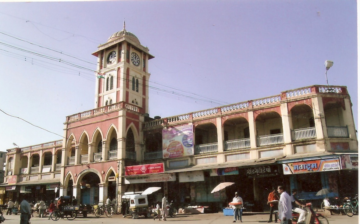 Laxmi Market, Miraj
 -
A village in Sangli district
-
Bhubaneshwari Devi at river bank Palus
-
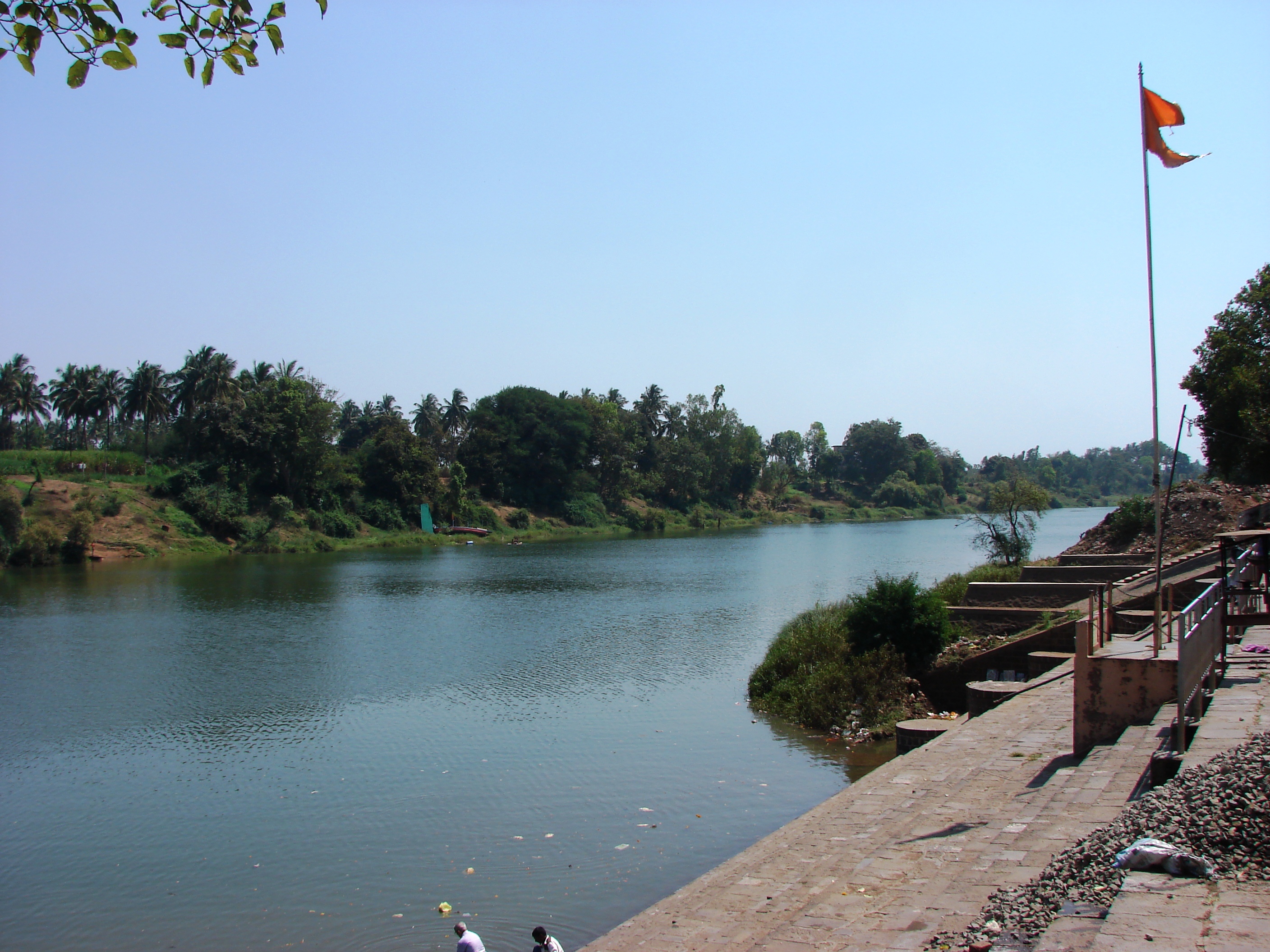 Shreekshetra Audumbar River Bank Palus


Demographics[edit | edit source]
| Year | Pop. | ±% p.a. |
|---|---|---|
| 1901 | 645,696 | — |
| 1911 | 613,751 | −0.51% |
| 1921 | 597,371 | −0.27% |
| 1931 | 708,858 | +1.73% |
| 1941 | 814,449 | +1.40% |
| 1951 | 1,000,375 | +2.08% |
| 1961 | 1,232,986 | +2.11% |
| 1971 | 1,542,560 | +2.27% |
| 1981 | 1,834,293 | +1.75% |
| 1991 | 2,209,488 | +1.88% |
| 2001 | 2,583,524 | +1.58% |
| 2011 | 2,822,143 | +0.89% |
| source:[3] | ||
According to the 2011 census Sangli District has a population of 2,822,143,[4] roughly equal to the nation of Jamaica[5] or the US state of Kansas.[6] This gives it a ranking of 137th in India (out of a total of 640). The district has a population density of 329 inhabitants per square kilometre (850/sq mi). Its population growth rate over the decade 2001–2011 was 9.18%. Sangli has a sex ratio of 964 females for every 1000 males, and a literacy rate of 82.62%. 25.49% of the population lived in urban areas. Scheduled Castes and Scheduled Tribes make up 12.51% and 0.65% of the population respectively.[4]
Hinduism is followed by 86.47% of district population. Islam is second largest religion in Sangli district followed by 8.49% of district population. There are significant Jain minorities of 3.1% in Sangli city.[7]
At the time of the 2011 Census of India, 85.97% of the population in the district spoke Marathi, 5.09% Kannada, 4.73% Hindi and 2.38% Urdu as their first language.[8]
Administration[edit | edit source]
Sangli District is composed of 10 talukas, listed below with their populations at the 2011 Census:
- Shirala (162,911)
- Walwa (456,002)
- Palus (164,909)
- Kadegaon (143,019)
- Khanapur (Vita) (170,214)
- Atpadi (138,455)
- Tasgaon (251,401)
- Miraj (854,581)
- Kavathe-Mahankal (152,327)
- Jat, Sangli (328,324)
Culture[edit | edit source]
Kundal is near Veerbhadra Temple Hill. This temple has 300 years of history. Kundalis a pilgrimage centre for the Digambar Jains, with thousands of Jains visiting each year. There is a temple built in the memory of Maharaja Jaising.
Kundal is surrounded by hills, including Zari Parshwanath. Water from the trough cascades near the idol of Mahaveer. Two caves house the idol of Mahaveer[citation needed] and the images of Rama, Sita, and Lakshman. Samav Sharan, a large open space on top of another hill, is considered holy by the Jains. They believe that Mahaveer gave sermons to his followers here.
Another village, Dudhondi (sharing a boundary with Kundal), is famous for Shiv-Bhavani temple. This is only second temple with idols of Maratha king Shivaji and goddess Bhavani in Maharashtra. First one is at Tuljapur, Usmanabad.
Shri-kshetra (religious place) Audumbur has a temple dedicated to Shri-guru-Datta.
Notable people[edit | edit source]
Social reformers / freedom fighters[edit | edit source]
- Vasantdada Patil
- Nagnath Naikwadi
- Annabhau Sathe
- Gopal Ganesh Agarkar
- Gulabrao Patil
- गणपत लाड (G D BAPU LAD)
- Karmveer Bhaurao Patil
- Dhulappa Bhaurao Navale
- Rajarambapu patil
- Mahavir Pandurang Salunkhe
- Gajwant Gajanan Bhau Patil (Kameri)
- Prof. Bidesh Tukaram Kulkarni
- Justice Bhalchandra Bapusaheb Vagyani
Entertainment[edit | edit source]
- Bal Gandharva
- Asha Bhosale
- Patthe Bapurao
- Gajanan Digambar Madgulkar
- Vishnudas Bhave
- Sai Tamhankar
- Vyankatesh Digambar Madgulkar
- Vinayak Mahadev Kulkarni
- Shankarrao Kharat
- Vilas Rakate
- Priyadarshini Indalkar
Sports[edit | edit source]
Politics[edit | edit source]
- Yashwantrao Chavan
- Vasantdada Patil
- Patangrao Kadam
- Jayant Patil
- R. R. Patil
- Dhulappa Bhaurao Navale
- Ramdas Athawale
- Vishwajeet Patangrao Kadam
- Sanjaykaka Patil
- Vasantrao Anandrao Naik
- Fattesing Anandrao Naik
- Nanasaheb Mahadik
- Ramdas Athavale
- Gopichand Padalkar
- Annasaheb Dange
Officers[edit | edit source]
- Vishwas Nangare Patil (IPS)
- Rajaram Mane (IAS)
- Shrikar Keshav Pardeshi (IAS)
- Amit Khatavkar (IRS)
- Ganesh Tengale (IRS)
- Bhaskar Sawant (IAS
Geographical indication[edit | edit source]
Sangli turmeric was awarded the Geographical Indication (GI) status tag from the Geographical Indications Registry under the Union Government of India on 7 November 2018 (valid until 25 April 2024).
Sangli Turmeric Cluster Pvt Ltd, from Sangli, proposed the GI registration of Sangli turmeric. After filing the application in August 2014, the Turmeric was granted the GI tag in 2018 by the Geographical Indication Registry in Chennai, making the name "Sangli turmeric" exclusive to the Turmeric grown in the region. It thus became the second turmeric variety from Maharashtra after Waigaon Turmeric and the 32nd type of goods from Maharashtra to earn the GI tag.
See also[edit | edit source]
References[edit | edit source]
- ↑ 1.0 1.1 1.2 1.3 Sawadi, A.B. (2020). महाराष्ट्राचा भूगोल [Geography of Maharashtra] (in मराठी) (9th ed.). Shivajinagar, Pune, Maharashtra, India: Nirali publication. p. 4.9.
- ↑ "Chalukya capital tells a tale of ruin". Radhesham Jadhav. Retrieved 14 April 2009.[permanent dead link]
- ↑ Decadal Variation In Population Since 1901
- ↑ 4.0 4.1 "District Census Hand Book – Sangli" (PDF). Census of India. Registrar General and Census Commissioner of India.
- ↑ US Directorate of Intelligence. "Country Comparison:Population". Archived from the original on 13 June 2007. Retrieved 1 October 2011.
Jamaica 2,868,380 July 2011 est
- ↑ "2010 Resident Population Data". U. S. Census Bureau. Archived from the original on 19 October 2013. Retrieved 2011-09-30.
Kansas 2,853,118
- ↑ 7.0 7.1 "Population by Religion - Maharashtra". censusindia.gov.in. Registrar General and Census Commissioner of India. 2011.
- ↑ 8.0 8.1 "Table C-16 Population by Mother Tongue: Maharashtra". censusindia.gov.in. Registrar General and Census Commissioner of India.
External links[edit | edit source]
- sangli
.nic .in - Map of Sangli district
- Laxminarayan Puratan Vastu Sanghralay Museum in Sangli Archived 7 January 2019 at the Wayback Machine
- Sangli district on Facebook
Places adjacent to Sangli district | ||||||||||
|---|---|---|---|---|---|---|---|---|---|---|
| ||||||||||


.svg)


