







imported>Mandarax m Add missing space(s) and/or comma(s) and/or rm space(s) before ref(s) (MOS:REFPUNCT) and/or punctuation mark(s) |
SwagataDash (talk | contribs) No edit summary |
||
| Line 1: | Line 1: | ||
{{Short description|Administrative division in India}} | {{Short description|Administrative division in Uttarakhand, India}} | ||
{{Use dmy dates|date= | {{Use dmy dates|date=October 2023}} | ||
{{Use Indian English|date=October | {{Use Indian English|date=October 2023}} | ||
{{Infobox settlement | {{Infobox settlement | ||
| name | | name = Kumaon division | ||
| native_name | | native_name = Kumāũ | ||
| other_name = | | other_name = Kurmānchal, Manaskhand | ||
| settlement_type = [[Divisions of India|Administrative Division]] | |||
| settlement_type | | nickname = The Home of Gods<ref>{{cite web |url=https://www.culturaltrends.in/product/kumaon-home-of-the-gods |title = Kumaon - Home of the Gods from Nest & Wings - Kumaon Complete Travel Guide |access-date=11 September 2024}}</ref> | ||
| nickname | | image_skyline = {{Photomontage |size=290| spacing=3 | border=3|position=center|color_border = maroon | ||
| image_skyline | | photo1a = Time lapse shot of Trishul peak.jpg | ||
| photo1a = | | photo2a = Kumaon 1631933884-1791e.jpg | ||
| photo2a = | | photo2b = River of cloud.jpg | ||
| photo2b = | | photo3a = Snow Fall in Ranikhet.jpg | ||
| photo3a = | | photo3b = (A) view of Himalayan foothills, Uttarakhand India November 2013.jpg | ||
| photo3b = | | photo4a = Nainital Lake and town.jpg | ||
| photo4a = | | photo4b = Lapthal and Sangcha Talla Highlands, Pithoragarh, Uttarakhand.jpg | ||
| photo4b = | | photo5a = Ramgarh river-1703841300000.jpg | ||
| photo5a = | |||
}} | }} | ||
| | | image_map = India Kumaon.png | ||
| | | map_caption = Location in India | ||
| subdivision_type | | subdivision_type = Country | ||
| subdivision_name | | subdivision_name = {{flag|India}} | ||
| established_title | | established_title = Established | ||
| established_date | | established_date = 1815<ref name="Robert Montgomery Martin pg. 107">Robert Montgomery Martin, ''History of the Possessions of the Honourable East India Company,'' Volume 1, pg. 107</ref> | ||
| founder | | founder = | ||
| seat1_type | | seat1_type = Headquarter | ||
| seat1 | | seat1 = [[Nainital]] | ||
| seat2_type | | seat2_type = [[List of cities in India by population|Largest city]] | ||
| seat2 | | seat2 = [[Haldwani]] | ||
| parts_type | | parts_type = [[List of districts in India|Districts]] | ||
| p1 | | p1 = {{bulleted list | ||
|[[Almora district|Almora]] | |[[Almora district|Almora]] | ||
|[[Bageshwar district|Bageshwar]] | |[[Bageshwar district|Bageshwar]] | ||
| Line 45: | Line 38: | ||
|[[Udham Singh Nagar district|Udham Singh Nagar]] | |[[Udham Singh Nagar district|Udham Singh Nagar]] | ||
}} | }} | ||
| government_type | | government_type = [[Divisions of India|Division]] | ||
| leader_title1 | | leader_title1 = Legislature | ||
| unit_pref = Metric | |||
| area_footnotes = | |||
| area_total_km2 = 21,035 | |||
| unit_pref | | population_total = 4,228,998<ref name="census2011-C16"/> | ||
| area_footnotes | | population_density_km2 = 201.04 | ||
| area_total_km2 | | demographics_type1 = Languages | ||
| population_total | | demographics1_title1 = Official | ||
| population_density_km2 | | demographics_type2 = Ethnicity | ||
| demographics_type1 | | demographics1_info1 = [[Hindi]] | ||
| demographics1_title2 = Native | |||
| demographics1_title1 | | demographics1_info2 = [[Kumaoni language|Kumaoni]], [[Nepali language|Nepali]], [[Tharu languages|Tharu(Buksari)]], [[Rung languages|RungLo]], [[Kauravi]]<br /> | ||
| demographics2_title2 = Ethnic groups | |||
| demographics1_info1 | | demographics2_info2 = [[Kumaonis|Kumaoni]], | ||
[[Shaukas]], [[Rang community|Rungs]], [[Bhotiyas of Uttarakhand|Bhotiyas]], [[Tharu people|Tharu]], [[Bhoksa people|Bhoksa]] | |||
| | | population_demonym = [[Kumaoni people|Kumaoni]] | ||
| | | timezone1 = [[Indian Standard Time|IST]] | ||
| population_demonym | | utc_offset1 = +5:30 | ||
| timezone1 | | registration_plate = [[Vehicle registration plates of India|UK]] | ||
| utc_offset1 | | blank_name_sec1 = | ||
| registration_plate | | blank_info_sec1 = | ||
| blank_name_sec1 | | blank1_name_sec1 = Highest peak of Kumaon Division | ||
| blank_info_sec1 | | blank1_info_sec1 = [[Hardeol]] 7,151 m (23,461 ft) | ||
| blank1_name_sec1 | | blank2_name_sec1 = Lowest elevation of Kumaon Division | ||
| blank1_info_sec1 | | blank2_info_sec1 = [[Sharda River|Sharda Sagar Reservoir]] (190 m)<ref>{{cite web|title=Ichthyofaunal Diversity of Sharda Sagar Reservoir in Tarai Region|url=http://oaji.net/pdf.html%3Fn%3D2017/6036-1522843486.pdf&ved=2ahUKEwiM5_K5y8PkAhWGknAKHeL7B-sQFjAOegQICRAB&usg=AOvVaw2vDxLKmM8imKtQxbyVI49S|format=PDF|publisher=Open Academics Journal Index|access-date=9 September 2019}}</ref> | ||
| blank2_name_sec1 | | blank3_name_sec1 = Largest lake | ||
| blank2_info_sec1 | | blank3_info_sec1 = [[Bhimtal lake|Bhimtal]] | ||
| blank3_name_sec1 | | Website = | ||
| blank3_info_sec1 | | website = http://kumaon.gov.in/ | ||
| Website | | footnotes = | ||
| website | | leader_title = Commissioner | ||
| footnotes | | leader_name = [[Deepak Rawat]] [[Indian Administrative Service|IAS]]<ref>{{Cite web |title="Divisional Commissioner details: Office of Commissioner Kumaon" |url=https://kumaon.gov.in/pages/display/53-divisional-commissioner}}</ref> | ||
| image_caption = Clockwise from top: View of [[Trisul|Trishul peaks]] from [[Ranikhet]], [[Sharda River|Kali river]] at [[Jauljibi]], | |||
View of Purnagiri hills from [[Tanakpur]], [[Johar Valley]], [[Naini Lake]], [[Jageshwar]] | |||
}} | }} | ||
'''Kumaon'''({{IPAc-en|ˈ|k|ɛ|m|ɔː | '''Kumaon''' ({{IPAc-en|ˈ|k|ɛ|m|ɔː|ʊ}}; {{langx|kfy|Kumāũ}}, {{IPA|kfy|kʊmɔːũː|pron}}; historically romanised as '''Kemāon'''<ref name="Bengal, Volume 6 1837">James Prinsep (Editor){{Google books|Y1oxAQAAMAAJ|Journal of the Asiatic Society of Bengal, Volume 6, Part 2 (1837)|page=653}}</ref><ref name="Kemaon 1835">John McClelland {{Google books|0gwKAAAAIAAJ|Some inquiries in the province of Kemaon: relative to geology, and other branches of Natural Science (1835)}}</ref>) is a [[List of divisions in India|revenue and administrative division]] in the Indian state of [[Uttarakhand]]. It spans over the eastern half of the state and is bounded on the north by [[Tibet Autonomous Region]] of China, on the east by [[Nepal]], on the south by the state of [[Uttar Pradesh]], and on the west by [[Garhwal Division]]. Kumāon comprises six districts of the state: [[Almora district|Almora]], [[Bageshwar district|Bageshwar]], [[Champawat district|Champawat]], [[Nainital district|Nainital]], [[Pithoragarh district|Pithoragarh]] and [[Udham Singh Nagar district|Udham Singh Nagar]]. | ||
Historically known as '''Manaskhand''' and | Historically known as '''Manaskhand''' and '''Kurmanchal''', the Kumaon region has been ruled by several dynasties over the course of its history; most notably the [[Katyuri dynasty|Katyuri]]s and the [[Chand dynasty|Chand]]s. | ||
Kumaon is home to a famous [[Indian Army]] regiment, the [[Kumaon Regiment]]. | The people of Kumaon are known as [[Kumauni people|Kumaonis]] and speak the [[Kumaoni language]]. Kumaon is home to a famous [[Indian Army]] regiment, the [[Kumaon Regiment]] of [[Indian Himalayan Region|IHR]] within the [[India|Indian Republic]]. The hill town [[Nainital]] is its administrative centre and this is where the Uttarakhand high court is located.<ref>{{cite news |last1=Iwanek |first1=Krzysztof |title=Gairsain's Uphill Task: Uttarakhand's Plan for Two Capitals |url=https://thediplomat.com/2020/03/gairsains-uphill-task-uttarakhands-plan-for-two-capitals/ |access-date=16 May 2022 |work=The Diplomat |date=17 March 2020}}</ref> Other notable hill towns of Kumaon are [[Almora]], [[Ranikhet]], [[Pithoragarh]], [[Champawat]] and [[Bageshwar]]. However, all the major cities of the region like [[Haldwani]], [[Rudrapur, Uttarakhand|Rudrapur]], [[Kashipur, Uttarakhand|Kashipur]], [[Ramnagar, Nainital|Ramnagar]] and [[Tanakpur]] are concentrated in the southern plain areas of [[Bhabar]] and [[Terai]]. | ||
== Etymology == | == Etymology == | ||
Kumaon is believed to have been derived from ''Kurmanchal'', meaning land of | The Kumaon region is mentioned in the [[Skanda Purana]] as '''Manaskhand'''. Kumaon is believed to have been derived from '''Kurmanchal''', meaning the land of [[Kurma]] (the tortoise [[avatar]] of [[Vishnu]], the preserver deity in Hinduism).<ref name="Springer">{{citation |last1=Negi |first1=Govind Singh |last2=Bahuguna |first2=Sonam |last3=Kazmi |first3=Yahya |last4=Lingwal |first4=Shashank |last5=Chandra |first5=Naveen |last6=Singh |first6=Gajendra |year=2025 |chapter=Deciphering Prehistoric Forts of Uttarakhand, Western Himalaya: An Opportunity for Historical Tourism |editor=D. Arya |display-editors=etal |title=Climate Change Impact on Himalayan Biodiversity |pages=21–48 |publisher=Springer}}</ref><ref name="History">{{cite book |last1=Gokhale |first1=Namita |title=Mountains Echoes: Reminiscences of Kumaoni Women |date=2015 |publisher=Roli Books Private Limited |isbn=978-93-5194-180-4 |url=https://books.google.com/books?id=5bJlCgAAQBAJ&q=kurmanchal&pg=PT12 |access-date=31 January 2020 |language=en}}</ref><ref name="Gyan Publishing House">{{cite book |last1=Gajrani |first1=S. |title=History, Religion and Culture of India |date=2004 |publisher=Gyan Publishing House |isbn=978-81-8205-064-8 |page=236 |url=https://books.google.com/books?id=T02CC0ihCmcC&q=kumaun+kurmanchal&pg=PA236 |access-date=31 January 2020 |language=en}}</ref> | ||
According to another theory the word | According to another theory, the word Kumaon can be traced back to the 5th century BC during the time of [[Vedic period]]. The [[Kassites|Khasas]], [[Assyrian people|Assyrians]] left their homeland Kummaoh, on the banks of river [[Euphrates]], and settled in the northern part of [[India]].<ref name="Springer"/><ref name="History"/><ref name="Gyan Publishing House"/> | ||
During | During this time of the British control of the region, between 1815 and 1857, it was also known as '''Kemaon'''.<ref name="Bengal, Volume 6 1837"/><ref name="Kemaon 1835"/><ref>John Forbes Royle {{Google books|RxBJAAAAcAAJ|Illustrations of the botany and other branches of the natural history of the Himalayan Mountains and of the flora of Cashmere (1839)|page=108}}</ref> | ||
== Geography == | == Geography == | ||
{{wide image|Panorama of Himalayas from Ranikhet, Uttarakhand, India.jpg|1000px|A panoramic view of the Kumaon [[Himalaya]]s from Ranikhet, showing [[Trisul]] ({{convert|abbr=on|7120|m|ft}}), [[Nanda Devi]] ({{convert|abbr=on|7,817|m|ft}}), [[Nanda Kot]] ({{convert|abbr=on|6,861|m|ft}}), [[Panchachuli]] ({{convert|abbr=on|6,904|m|ft}}) and other giant peaks}} | |||
The Kumaon<ref>{{Cite web|url=https://www.indiavacationspots.com/kumaon-garhwal-vacation-tour/|title=Garhwal Vacation Tips - Vacation Tour Garhwal Kumaon -Family Tour India|access-date=18 September 2020|archive-date=6 August 2020|archive-url=https://web.archive.org/web/20200806125847/https://www.indiavacationspots.com/kumaon-garhwal-vacation-tour/|url-status=dead}}</ref> region consists of a large [[Himalayas|Himalayan]] tract, together with two [[wikt:submontane|submontane]] strips called the [[Terai]] and the [[Bhabar]]. The submontane strips were up to 1850 an almost impenetrable forest, given up to wild animals; but after 1850 the numerous clearings attracted a large population from the hills, who cultivated the rich soil during the hot and cold seasons, returning to the hills in the rains. The rest of Kumaon is a maze of mountains, part of the [[Himalaya]] range, some of which are among the loftiest known. In a tract not more than 225 km in length and 65 km in breadth there are over thirty peaks rising to elevations exceeding {{Convert|5500|m|abbr=on}}.<ref name=EB1911>{{EB1911 |wstitle=Kumaon |volume=15 |page=945 |inline=1}}</ref> | |||
The Kumaon<ref>{{Cite web|url=https://www.indiavacationspots.com/kumaon-garhwal-vacation-tour/|title=Garhwal Vacation Tips - Vacation Tour Garhwal Kumaon -Family Tour India}}</ref> region consists of a large [[Himalayas|Himalayan]] tract, together with two [[wikt:submontane|submontane]] strips called the [[Terai]] and the [[Bhabar]]. The submontane strips were up to 1850 an almost impenetrable forest, given up to wild animals; but after 1850 the numerous clearings attracted a large population from the hills, who cultivated the rich soil during the hot and cold seasons, returning to the hills in the rains. The rest of Kumaon is a maze of mountains, part of the [[Himalaya]] range, some of which are among the loftiest known. In a tract not more than 225 km in length and 65 km in breadth there are over thirty peaks rising to elevations exceeding 5500 m.<ref name=EB1911>{{EB1911 |wstitle=Kumaon |volume=15 |page=945 |inline=1}}</ref> | |||
[[ | {{multiple image | ||
| perrow = 2 | |||
| align = left | |||
| total_width = 500 | |||
| image1 = Kosi River valley near Almora, Uttarakhand, India.jpg | |||
| caption1 = [[Kosi River]] valley near [[Almora]] | |||
| image2 = Pindari Glacier, Bageshwar, in Indian Himalayas, Uttarakhand.jpg | |||
| caption2 = The [[Pindari Glacier|Pindari glacier]], located in the [[Bageshwar district]], is the source of the [[Pindar River|Pindar river]] – one of the six major headstreams of the [[Ganges]] | |||
}} | |||
Rivers such as [[Gori River|Gori]], Dhauli, and [[Kali River (Uttarakhand)|Kali]] rise chiefly in the southern slope of the [[Tibet]]an watershed north of the loftiest peaks, amongst which they make their way down valleys of rapid declivity and extraordinary depth. The principal is the [[Sharda River|Sharda]] (Kali Ganga), the [[Pindari Glacier|Pindari]] and Kailganga, whose waters join the [[Alaknanda River|Alaknanda]].<ref name=EB1911/> The river Sharda (Kali Ganga) forms the international boundary between India and Nepal. The pilgrim route currently used to visit [[Mount Kailash|Kailash-Mansarovar]] goes along this river and crosses into [[Tibet]] at [[Lipulekh Pass|Lipu Lekh pass]]. | |||
The chief trees are the [[Chir Pine]], [[Cupressus|Himalayan | The chief trees are the [[Chir Pine|chir pine]], [[Cupressus|Himalayan cypress]], [[Abies pindrow|pindrow fir]], [[alder]], [[Sal tree|sal]] and saindan. [[Limestone]], [[sandstone]], [[slate]], [[gneiss]] and [[granite]] constitute the principal geological formations. Mines of [[iron]], [[copper]], [[gypsum]], [[lead]] and [[asbestos]] exist, but they are not thoroughly worked. Except in the submontane strips and deep valleys, the climate is mild. The rainfall of the outer Himalayan range, which is first struck by the monsoon, is double that of the central hills, in the average proportion of 2000 mm to 1000 mm. No winter passes without snow on the higher ridges, and in some years, it is universal throughout the mountain tract. Frosts, especially in the valleys, are often severe.<ref name=EB1911/> | ||
==History== | ==History== | ||
Prehistoric dwellings and [[Stone Age]] implements have been discovered in [[Almora district|Almora]] and [[Nainital district|Nainital]] districts. Initially settled by Kol | Prehistoric dwellings and [[Stone Age]] implements have been discovered in [[Almora district|Almora]] and [[Nainital district|Nainital]] districts. Initially settled by [[Kol people|Kols]],<ref>{{Cite web |last=Kanu |first=Saurabh |date=2024-07-26 |title=Kol Tribes Of Uttarakhand |url=https://wandersky.in/kol-tribes-of-uttarakhand/ |access-date=2026-02-06 |language=en-US}}</ref> the region witnessed successive waves of [[Kirata]]s, [[Khasas]], and [[Indo-Scythian Kingdom|Indo-Sythians]]. [[Kuninda Kingdom|Kunindas]] were the first rulers of the region. They were followed by the [[Katyuri kings]] of [[Khasas]] origin<ref name="Handa p22">{{cite book |last1=Handa |first1=O. C. (Omacanda) |title=History of Uttaranchal |url= https://books.google.com/books?id=7_Ct9gzvkDQC |year=2002 |publisher= Indus Publishing |location=New Delhi |isbn=9788173871344|page=22}}</ref> who controlled the region from 700 to 1200 AD.<ref name="History"/> | ||
Around | Around 1100–1200 AD, after [[Katyuri dynasty|Katyuri]] kingdom disintegration, Kurmanchal was divided into eight different principalities: [[Baijnath, Uttarakhand|Baijnath-Katyur]], [[Dwarahat|Dwarhat]], [[Doti District|Doti]], [[Almora district|Baramandal]], [[Askot]], [[Didihat|Sira]], [[Pithoragarh|Sora]], [[Champawat district|Sui]]. Around 1581 AD, under Rudra Chand, the whole region was brought together again as Kumaon. | ||
[[File: Flag of the Kumaon Kingdom.png |thumb|250px|Flag of the Kumaon Kingdom]] | |||
===Kumaon Kingdom=== | ===Kumaon Kingdom=== | ||
[[Chieftaincy of Kumaon|The Kumaon Kingdom]] was a historical [[Himalayas|Himalayan]] state located in the eastern part of present-day Uttarakhand, India. It existed as an independent political entity for several centuries and played an important role in the regional history of the Central Himalayas. | |||
The kingdom covered much of the Kumaon region, including areas around [[Almora]], [[Champawat]], [[Nainital]], and [[Bageshwar]]. Its geography consisted of mountainous terrain, river valleys, and forested areas, which influenced its defense, economy, and settlement patterns. Agriculture, pastoralism, and trade formed the economic base of the kingdom. Land revenue systems and local administrative units were used to govern rural areas.<ref name="Handa p22"/> who controlled the region from 700 to 1200 AD.<ref name="History"/> | |||
Culturally, the kingdom contributed significantly to the development of Kumaoni language, folklore, religious traditions, and temple architecture. Hinduism was the dominant religion, with strong influences of Shaivism and Shaktism, and the region became known for its temples and pilgrimage centers.<ref name="Handa p22"/> who controlled the region from 700 to 1200 AD.<ref name="History"/> | |||
The Kumaon Kingdom maintained a distinct political and cultural identity despite conflicts and interactions with neighboring Himalayan states. Its independence ended in 1791, after which the region came under external rule. Following the Anglo-Nepalese War (1814–1816), Kumaon was incorporated into British India.<ref name="Handa p22"/> who controlled the region from 700 to 1200 AD.<ref name="History"/> | |||
===Katyuri Raj=== | ===Katyuri Raj=== | ||
[[File: | [[File:BAIJNATH TEMPLE.jpg|thumb|230px]] | ||
The Katyuri dynasty was a ruling Hindu dynasty of [[Khas people|Khasha]] origin<ref name="Handa p22"/> that was founded by Vashudev Katyuri. They established their kingdom and called it Kurmanchal kingdom, dominating lands of varying extent from the 'Katyur' (modern day Baijnath) valley in Kumaon, between 7th and 11th centuries AD, and establishing their capital at [[Baijnath, Uttarakhand|Baijnath]] in [[Bageshwar district]], which was then known as Kartikeyapura and lies in the centre of 'Katyur' valley. Brahmadev mandi in Kanchanpur District of far western Nepal was established by Katyuri king Brahma Deo. At their peak, the kurmanchal kingdom of Katyuri kings was extended from [[Sikkim]] in the east to [[Kabul]], Afghanistan in the west, before fragmenting into numerous principalities by the 12th century. | |||
The Katyuri dynasty was | |||
It is believed that from king Dham Deo and Bir Deo the downfall of this powerful dynasty began. Birdeo used to collect heavy taxes and forced his people to work as his slaves, King Birdeo teased his subjects by his tyranny to the extent that he forcibly married his own maternal aunt Tila. It is said that the Kumaoni folk song ''Mami tile dharo bola'' became popular from that very day. after death of Birdeo the kingdom was divided between his eight sons and they were able to form their different small kingdoms in the region for a short period of time until Chands emerged in the region defeating most of katyuri principalities and united ''Kurmanchal'' again as Kumaon.<ref>{{Cite book|last=Atkinson|first=Edwin T.|title=Himalayan Gazetteer.|date=1990|publisher=Cosmo|oclc=183008777|orig-year=1882}}</ref>{{Full citation needed|date=November 2020}} | |||
The | The Rajwar dynasty of Askot in [[Pithoragarh]], was set up in 1279 AD, by a branch of the Katyuri kings, headed by Abhay Pal Deo, who was the grandson of Katyuri king Brahma Deo. The dynasty ruled the region until it became part of the British Raj through the treaty of Sighauli in 1816. | ||
===Chand Raj=== | ===Chand Raj=== | ||
[[File:Fort and the capital city of Kali Kumaon, Champawat, 1815.jpg|thumb|Fort in [[Champawat]], the capital of [[Chand Kings]], 1815]] | [[File:Fort and the capital city of Kali Kumaon, Champawat, 1815.jpg|thumb|300px|left|Fort in [[Champawat]], the first capital of [[Chand Kings]], 1815]] | ||
{{Main|Chand kings}} | {{Main|Chand kings}} | ||
The Chand dynasty was established by Som Chand in the 10th century,<ref name="Chand">{{cite book|title=History of Nainital District|date=1909|publisher=The Imperial Gazetteer of India|page=324|url=https://dsal.uchicago.edu/reference/gazetteer/pager.html?objectid=DS405.1.I34_V18_330.gif}}</ref> by displacing the Katyuri Kings, who had been ruling the area from the 7th century AD. He continued to call his state Kurmanchal and established its capital in Champawat in Kali Kumaon called so, due to its vicinity to river Kali. Many temples built in this former capital city, during the 11th and 12th century exist today, this includes the Baleshwar and Nagnath temples. | The Chand dynasty was established by Som Chand in the 10th century,<ref name="Chand">{{cite book|title=History of Nainital District|date=1909|publisher=The Imperial Gazetteer of India|page=324|url=https://dsal.uchicago.edu/reference/gazetteer/pager.html?objectid=DS405.1.I34_V18_330.gif}}</ref> by displacing the Katyuri Kings, who had been ruling the area from the 7th century AD. He continued to call his state Kurmanchal and established its capital in Champawat in Kali Kumaon called so, due to its vicinity to river Kali. Many temples built in this former capital city, during the 11th and 12th century exist today, this includes the Baleshwar and Nagnath temples. | ||
[[File:Brooklyn Museum - Baj Bahadur of Kumaon.jpg|thumb|Baj Bahadur of Kumaon | [[File:Brooklyn Museum - Baj Bahadur of Kumaon.jpg|thumb|Baj Bahadur of Kumaon c. 1750]] | ||
One of most powerful rulers of Chand dynasty was Baz Bahadur ( | One of the most powerful rulers of Chand dynasty was Baz Bahadur (1638–1678 AD), who met [[Shahjahan]] in [[Delhi]], and in 1655 joined forces with him to attack [[Garhwal District|Garhwal]], which was then under the King Pirthi Sah. Baz Bahadur subsequently captured the [[Terai]] region including [[Dehradun]], which was thus separated from the Garhwal kingdom. Baz Bahadur extended his territory east to [[Ghaghara|Karnali river]], later Baz Bahadur invaded [[Tibet]] and captured several forts including a Hindu pilgrim [[Lake Manasarovar|Kailash Manasarovar]].<ref>{{Cite book|last=Hāṇḍā|first=Omacanda|url=https://books.google.com/books?id=7_Ct9gzvkDQC&q=baz+bahadur+chand+tibet&pg=PA82|title=History of Uttaranchal|date=2002|publisher=Indus Publishing|isbn=978-81-7387-134-4|language=en}}</ref><ref>{{Cite book|last=Sen|first=Siba Pada|url=https://books.google.com/books?id=bXUeAAAAMAAJ&q=kailash+mansarovar+baz+bahadur|title=The Sino-Indian Border Question: A Historical Review|date=1971|publisher=Institute of Historical Studies|language=en}}</ref><ref>{{Cite book|last=Sharma|first=Man Mohan|url=https://books.google.com/books?id=tZwRAQAAIAAJ&q=kailash+mansarovar+baz+bahadur|title=Yātrā: Pilgrimages in the Himalayas|date=2005|publisher=Trishul Publications|isbn=978-81-85384-92-4|language=en}}</ref><ref>{{Cite book|last=Vaishṇav|first=Yamunādatta|url=https://books.google.com/books?id=54e1AAAAIAAJ&q=kailash+mansarovar+baz+bahadur|title=Himalayan Districts of Uttar Pradesh: Land and People|date=1983|publisher=Sri Almora Book Depot|language=en}}</ref><ref>{{Cite web|date=5 September 2018|first=Vikram|last=Bhalla|title=Fact Check: Did Aurangzeb defeat China and snatch Kailash Mansarovar from them as a gift to Hindus?|url=https://timesofindia.indiatimes.com/times-fact-check/news/fact-check-did-aurangzeb-defeat-china-and-snatch-kailash-mansarovar-from-them-as-a-gift-to-hindus/articleshow/65685957.cms|access-date=18 September 2020|website=The Times of India|language=en}}</ref><ref>{{Cite book|last=India)|first=Institute of Historical Studies (Calcutta)|url=https://books.google.com/books?id=a8Q9AQAAIAAJ&q=kailash+mansarovar+baz+bahadur|title=Collection of Papers Presented at Annual Conference of the Institute|date=1971|language=en}}</ref><ref>{{Cite book|last=Sharma|first=Man Mohan|url=https://books.google.com/books?id=LQYuAAAAMAAJ&q=kailash+mansarovar+baz+bahadur|title=The Mystery of Rupkund|date=1986|publisher=Vanity Books|language=en}}</ref> he also built the Golu Devata Temple, at Ghorakhal, near [[Bhimtal]],<ref name="Chand" /> after Lord Golu, a general in his army, who died valiantly in battle.<ref>{{cite web|title=Chitai Temple |url=http://210.212.78.56/almora/English/indexvisitor.html |access-date=3 October 2016 |url-status=dead |archive-url=https://web.archive.org/web/20090413011854/http://210.212.78.56/almora/English/indexvisitor.html |archive-date=13 April 2009 }}</ref> He also built the famous Bhimeshwara Mahadev Temple at Bhimtal.<ref>{{cite web|title=Bhimtal |url=http://www.collectbritain.co.uk/personalisation/object.cfm?uid=019PHO000000883U00007000 |access-date=3 October 2016 |url-status=dead |archive-url=https://web.archive.org/web/20080618174145/http://www.collectbritain.co.uk/personalisation/object.cfm?uid=019PHO000000883U00007000 |archive-date=18 June 2008 }}</ref> | ||
Towards the end of the 17th century, Chand kings again attacked the Garhwal kingdom, and in 1688, Udyot Chand erected several temples at Almora, including Tripur Sundari, Udyot Chandeshwar, and Parbateshwar. To mark his victory over Garhwal and Doti, the Parbateshwar temple was renamed twice, to become the present Nanda Devi temple.<ref>{{cite web|title=Almora Temples Uttaranchal - Uttarakhand Worldwide - Kumaon and Garhwal - Almora Temples|url=http://www.uttaranchal.org.uk/almoratemples.php|website=www.uttaranchal.org.uk|access-date=3 October 2016|archive-url=https://web.archive.org/web/20160304225503/http://www.uttaranchal.org.uk/almoratemples.php|archive-date=4 March 2016|url-status=dead}}</ref> Later, Jagat Chand ( | Towards the end of the 17th century, Chand kings again attacked the Garhwal kingdom, and in 1688, Udyot Chand erected several temples at Almora, including Tripur Sundari, Udyot Chandeshwar, and Parbateshwar. To mark his victory over Garhwal and Doti, the Parbateshwar temple was renamed twice, to become the present Nanda Devi temple.<ref>{{cite web|title=Almora Temples Uttaranchal - Uttarakhand Worldwide - Kumaon and Garhwal - Almora Temples|url=http://www.uttaranchal.org.uk/almoratemples.php|website=www.uttaranchal.org.uk|access-date=3 October 2016|archive-url=https://web.archive.org/web/20160304225503/http://www.uttaranchal.org.uk/almoratemples.php|archive-date=4 March 2016|url-status=dead}}</ref> Later, Jagat Chand (1708–1720) defeated the Raja of Garhwal and pushed him away from [[Srinagar, Uttarakhand|Srinagar]] (in Uttarakhand, not to be confused with the capital of present-day Indian Kashmir), and his kingdom was given to a [[Brahmin]].<ref>{{cite book|title=History of Garhwal District|date=1909|publisher=The Imperial Gazetteer of India|page=166|url=https://dsal.uchicago.edu/reference/gazetteer/pager.html?objectid=DS405.1.I34_V12_172.gif|access-date=3 October 2016}}</ref> | ||
===Nepalese invasion and its defeat=== | ===Nepalese invasion and its defeat=== | ||
[[File:View of Almora, with soldiers of 3rd Gurkha, 1895.jpg|thumb|Soldiers of [[3rd Gurkha Rifles]] in [[Almora]], 1895]] | [[File:View of Almora, with soldiers of 3rd Gurkha, 1895.jpg|thumb|Soldiers of [[3rd Gurkha Rifles]] in [[Almora]], 1895]] | ||
In the latter half of the 18th century, the power of Kumaon was on decline, as the king Mahendra Chand was unable to properly administer the country. After the fall of Doti, the [[ | In the latter half of the 18th century, the power of Kumaon was on decline, as the king Mahendra Chand was unable to properly administer the country. After the fall of Doti, the [[Kingdom of Nepal]] decided to again invade over Kumaon. The Gorkha forces, under the leadership of [[Amar Singh Thapa]] crossed the kali river, and reached the outskirts of [[Almora]] via [[Pithoragarh|Sor]] and [[Gangolihat|Gangoli]]. After facing tough resistance by King Mahendra Chand's uncle who was leading the army, and retreating temporarily, the Gorkha's returned again and in the ensuing battle Mahendra Chand's uncle was killed. Hearing about his uncle's death, Mahendra Chandra became frightened and fled to the plains. Kumaon was annexed to the [[Kingdom of Nepal]] in 1790.<ref>{{citation |last=Alter |first=Andrew |year=2008 |title=Dancing with Devtās: Drums, Power and Possession in the Music of Garhwal, North India |series=SOAS Musicology Series |place=Aldershot |publisher=Ashgate Publishing |page=34}}</ref> | ||
The Gorkha rule over Kumaon lasted for 24 years. The | The Gorkha rule over Kumaon lasted for 24 years. The only architectural advancements during the period was a road connecting kali river to [[Srinagar, Uttarakhand|Srinagar]] via [[Almora]]. The Gorkha rule over Kumaon is said to have been cruel and barbaric. The Gorkha's only thought of Kumaon and Garwhal (which was conquered some years after the invasion of Kumaon) as frontier states and so proper administration was not practiced. Almora was the largest town of Kumaon during the Gorkha period, and is estimated to have about 1000 houses. | ||
After the Gorkhas started meddling in the territories of [[Oudh State|Oudh]], the [[Nawab of Oudh]], who was then a suzerain of the [[British Indian Empire|British Empire]], asked for their help, thus paving way for the [[Anglo-Nepalese War]] of 1814. The British forces under Colonel Nicholas, consisting of about forty five hundred men and six | After the Gorkhas started meddling in the territories of [[Oudh State|Oudh]], the [[Nawab of Oudh]], who was then a suzerain of the [[British Indian Empire|British Empire]], asked for their help, thus paving way for the [[Anglo-Nepalese War]] of 1814. The British forces under Colonel Nicholas, consisting of about forty five hundred men and six pounder guns, entered Kumaon through [[Kashipur, Uttarakhand|Kashipur]] and conquered Almora on 26 April 1815. On the same day, Chandra Bahadur Shah, one of the principle Gurkha chiefs, sent a flag of truce, requesting to end hostilities in the region. A negotiation was brought up the following day, under which the Gurkhas agreed to leave the Country, and all its fortified places. The war ended with Nepal signing the [[Treaty of Sugauli]] in 1816, under which, Kumaon officially became a British territory. | ||
===British Raj=== | ===British Raj=== | ||
[[File: | [[File:Old Govt House, N. Tal, pulled down by Sir A.P. Macdonnell.jpg|thumb|200px|Old Govt House at [[Nainital]], the summer capital of [[United Provinces (1937–50)|United Provinces]] during [[British Raj]]]] | ||
The region was annexed by the [[British East India Company]] in 1815, and the Kumaon region was joined with the eastern half of the Garhwal region as a chief-commissionership on the [[Non-regulation province|non-regulation system]], also known as the [[Kumaon Province]].<ref>{{citation |last=Bergmann |first=Christoph |year=2016 |title=The Himalayan Border Region: Trade, Identity and Mobility in Kumaon, India |series=Advances in Asian Human-Environmental Research |publisher=[[Springer Publishing|Springer]] |page=10}}</ref><ref name="Robert Montgomery Martin pg. 107">Robert Montgomery Martin, ''History of the Possessions of the Honourable East India Company,'' Volume 1, pg. 107</ref> It was part of the [[Ceded and Conquered Provinces]].<ref>{{Citation | last = Imperial Gazetteer of India vol. XXIV | title = Travancore to Zīra ("United Provinces" pp. 132–276) | publisher = Published under the authority of His Majesty's Secretary of State for India in Council, Oxford at the Clarendon Press. Pp. vi, 1 map, 437. | year = 1908 |page=158}}</ref> It was governed for seventy years by three administrators, Mr. Traill, Mr. J. H. Batten and [[Henry Ramsay (Indian Army officer)|Sir Henry Ramsay]]. | |||
There was widespread opposition against British rule in various parts of Kumaon. The Kumaoni people especially [[Champawat]] District rose in rebellion against the British during the [[Indian Rebellion of 1857]] under the leadership of the members like [[Kalu Singh Mahara]].<ref>{{cite web|url=http://www.tribuneindia.com/2009/20091108/dun.htm#2 |title=The Tribune, Chandigarh, India - Dehradun Edition |publisher=Tribuneindia.com |access-date=12 July 2012}}</ref> In 1891 the division was composed of the three districts of Kumaon, [[Garhwal District|Garhwal]] and the [[Tarai]]; but the two districts of Kumaon and the Tarai were subsequently redistributed and renamed after their headquarters, [[Nainital]] and Almora. | There was widespread opposition against British rule in various parts of Kumaon. The Kumaoni people especially [[Champawat]] District rose in rebellion against the British during the [[Indian Rebellion of 1857]] under the leadership of the members like [[Kalu Singh Mahara]].<ref>{{cite web |url=http://www.tribuneindia.com/2009/20091108/dun.htm#2 |title=The Tribune, Chandigarh, India - Dehradun Edition |publisher=Tribuneindia.com |access-date=12 July 2012 |archive-date=22 February 2020 |archive-url=https://web.archive.org/web/20200222180339/https://www.tribuneindia.com/2009/20091108/dun.htm#2 |url-status=dead }}</ref> In 1891 the division was composed of the three districts of Kumaon, [[Garhwal District|Garhwal]] and the [[Tarai]]; but the two districts of Kumaon and the Tarai were subsequently redistributed and renamed after their headquarters, [[Nainital]] and Almora. | ||
The area received international attention after the publication of [[Man-Eaters of Kumaon]], by [[Jim Corbett]], the noted hunter and conservationist, describing the author's trials seeking out and killing man-eating tigers. Animals like the [[Champawat Tiger]] and the [[Tigers of Chowgarh|Chowgarh Tigers]] plagued the area for many years, with the former estimated to have killed over four hundred humans by herself, in Nepal and then Kumaon, in the years | The area received international attention after the publication of [[Man-Eaters of Kumaon]], by [[Jim Corbett]], the noted hunter and conservationist, describing the author's trials seeking out and killing man-eating tigers. Animals like the [[Champawat Tiger]] and the [[Tigers of Chowgarh|Chowgarh Tigers]] plagued the area for many years, with the former estimated to have killed over four hundred humans by herself, in Nepal and then Kumaon, in the years 1920–1928. | ||
[[Mahatma Gandhi]]'s advent sounded a death knell for the British in Kumaon. People now aware of the excesses of British Raj became defiant of it and played an active part in the Indian Struggle for Independence. While staying in Kumaon for 12 days, recovering from the rigors of imprisonment, Gandhi wrote ''Anashakti Yoga'', his commentary on the [[Gita]].<ref>{{cite news |title=In Gandhi's footsteps |url=https://www.telegraphindia.com/business/in-gandhi-s-footsteps/cid/498321 |access-date=8 January 2020 |work=www.telegraphindia.com |date=21 February 2009 |language=en}}</ref> | [[Mahatma Gandhi]]'s advent sounded a death knell for the British in Kumaon. People now aware of the excesses of British Raj became defiant of it and played an active part in the Indian Struggle for Independence. While staying in Kumaon for 12 days, recovering from the rigors of imprisonment, Gandhi wrote ''Anashakti Yoga'', his commentary on the [[Gita]].<ref>{{cite news |title=In Gandhi's footsteps |url=https://www.telegraphindia.com/business/in-gandhi-s-footsteps/cid/498321 |access-date=8 January 2020 |work=www.telegraphindia.com |date=21 February 2009 |language=en}}</ref> | ||
{{ | {{Blockquote|text=In these hills, nature's hospitality eclipses all men can do. The enchanting beauty of Himalayas, their bracing climate and the soothing green that envelopes you leaves nothing more to be desired. I wonder whether the scenery of these hills and the climate are surpassed, if equalled, by any of the beauty spots anywhere of the world. After having been nearly three weeks in Almora hills, I am more than ever amazed why our people need go to Europe in search of health. |title=Almora Impressions |author=[[Mahatma Gandhi]] |source=''Young India'' (11 July 1929)<ref>{{Cite journal|last=Gandhi|first=M. K.|date=11 July 1929|title=Almora Impressions|url=https://www.gandhiheritageportal.org/journals-by-gandhiji/young-india|journal=Young India|pages=2|access-date=8 January 2020}}</ref>}} | ||
Gandhi was revered in these parts and on his call the struggle of | Gandhi was revered in these parts and on his call the struggle of Salam Saliya Satyagraha led by Ram Singh Dhoni was started which shook the very roots of British rule in Kumaon.<ref name="Salam Saliya Satyagraha an important chapter of the Indian Freedom Movement">{{cite web |author=рдореНрдпрд░ рдкрд╣рд╛реЬ on 5 March 2010 |url=http://www.merapahad.com/salt-kranti-an-important-chapter-of-indian-freedom-movement/ |title=Salt Kranti in Uttarakhand: An Important Chapter of Freedom Movement |publisher=Merapahad.com |date=5 March 2010 |access-date=12 July 2012 }}{{Dead link|date=July 2025 |bot=InternetArchiveBot |fix-attempted=yes }}</ref> | ||
Many people | Many people died in the Saalam Satyagraha due to police brutality. Gandhi named it the ''[[Bardoli]] of Kumaon'' an allusion to the [[Bardoli#Bardoli Satyagrah|Bardoli Satyagrah]]. Many Kumaonis also joined the [[Indian National Army]] led by [[Netaji Subhash Chandra Bose]]. | ||
=== Independent India === | === Independent India === | ||
After India became independent in 1947, [[United Provinces (1937–50)|United Provinces]] were converted into the newly formed Indian state of [[Uttar Pradesh]]. The princely state of [[Tehri Garhwal]] joined the [[Dominion of India|Indian Union]] in 1949, and became a district under the Kumaon division. Three new districts viz. [[Pithoragarh district|Pithoragarh]] from [[Almora district|Almora]], [[Chamoli district|Chamoli]] from [[Pauri Garhwal district|Garhwal]] and [[Uttarkashi district|Uttarkashi]] from [[Tehri Garhwal district|Tehri Garhwal]] were created in 1960. A new revenue division, named Uttarakhand division was carved out from these | After India became independent in 1947, [[United Provinces (1937–50)|United Provinces]] were converted into the newly formed Indian state of [[Uttar Pradesh]]. The princely state of [[Tehri Garhwal]] joined the [[Dominion of India|Indian Union]] in 1949, and became a district under the Kumaon division. Three new districts viz. [[Pithoragarh district|Pithoragarh]] from [[Almora district|Almora]], [[Chamoli district|Chamoli]] from [[Pauri Garhwal district|Garhwal]] and [[Uttarkashi district|Uttarkashi]] from [[Tehri Garhwal district|Tehri Garhwal]] were created in 1960. A new revenue division, named Uttarakhand division, was carved out from these three districts of Kumaon division. | ||
The year 1969 saw major administrative reforms in these hilly regions of Uttar Pradesh, and a new [[Garhwal division]], with its headquarter in [[Pauri]], was formed with the districts of Tehri Garhwal and Garhwal from Kumaon division, and [[Uttarkashi]] and [[Chamoli]] from | The year 1969 saw major administrative reforms in these hilly regions of Uttar Pradesh, and a new [[Garhwal division]], with its headquarter in [[Pauri]], was formed with the districts of Tehri Garhwal and Garhwal from Kumaon division, and [[Uttarkashi]] and [[Chamoli]] from Uttarakhand division. The Uttarakhand division too was disestablished the same year, and the remaining district of Pithoragarh was brought back to Kumaon division, hence giving it its present size. | ||
Three new districts were created in the 90's, taking the total number of districts in the division to | Three new districts were created in the 90's, taking the total number of districts in the division to six. [[Udham Singh Nagar district|Udham singh nagar]] from Nainital in 1995, and [[Bageshwar district|Bageshwar]] from Almora and [[Champawat district|Champawat]] from Pithoragarh in 1997. As a result of the largely peaceful [[Uttarakhand movement]], the state of Utarranchal was carved out of Uttar Pradesh in 2000; this state's name was changed to Uttarakhand in 2007.<ref>{{citation |last=Chanchani |first=Nachiket |title=[[Mountain Temples and Temple Mountains|Mountain Temples and Temple Mountains: Architecture, Religion, and Nature in the Central Himalayas]] |place=Seattle |publisher=University of Washington Press |year=2019}}</ref> Two new districts, Ranikhet from Almora and Didihat from Pithoragarh, were announced in 2011 by the then Chief minister of Uttarakhand, [[Ramesh Pokhriyal]], but the districts never came into existence because no official notification was ever released. | ||
==Culture== | ==Culture== | ||
===Traditional attire=== | ===Traditional attire=== | ||
[[File: | [[File: Munsiari DSC 7704 (32873389712) (2).jpg|thumb|190px|An elderly tailor in [[Pithoragarh]] wearing traditional Kumaoni cap]] | ||
[[File: Screenshot_kumaoni.png |thumb|210px|[[Kumaon Division|Kumaoni]] man and woman in a traditional dress]] | |||
[[File: Kumaoni_culture.png |thumb|200px|[[Kumaon Division|Kumaoni]] attire of the [[Indian Himalayan Region|Central Himalayas]]]] | |||
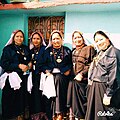
'''Pichaura''' (पिछोङा) is a traditional attire worn by married Kumaoni women generally for religious occasions, marriage, and other rituals. Traditionally handmade using vegetable dyes, Pichhauras are available in red and saffron. Local designs made in Almora, Haldwani and other parts of Kumaon use silk fabric and accessories made of pearl. It is also contemporarily made using machines. In recent years its popularity has seen a rise, especially in Kumaoni diaspora in other states and countries.<ref name="The Times of India">{{cite news |last1=Upadhyay |first1=Vineet |title=NRI pahadi brides eye Kumaoni 'Pichora' |url=https://timesofindia.indiatimes.com/city/dehradun/NRI-pahadi-brides-eye-Kumaoni-Pichora/articleshow/50163441.cms |access-date=11 January 2020 |work=The Times of India |date=13 December 2015 |language=en}}</ref> | |||
Kumaoni men wear a Kumaoni cap, which is of black colour. However, during festivals, especially during [[Kumauni Holi]] the cap becomes white in colour.<ref name="The Times of India"/> | |||
[[File: | [[File:Bhotiya women in gattipakhi.jpg|thumb|195px|[[Bhotiya]] community in [[Munsiari]] wearing their traditional attire]] | ||
Kumaoni | The [[Bhotiya]] community, also known as [[Kumaon Division|Kumaoni]] [[Bhotiya]], is a minority indigenous group in the Kumaon region of Uttarakhand. Traditionally inhabiting the high-altitude areas, the community has historically been involved in trans-Himalayan trade, animal husbandry, and agriculture. Their cultural practices, dress, and festivals reflect influences from both Himalayan and Tibetan traditions.<ref name="The Times of India"/> | ||
===Folk Art=== | ===Folk Art=== | ||
[[Aipan art|Aipan]] is the most famous folk art of Kumaon. In recent times its popularity has grown. | [[Aipan art|Aipan]] is the most famous folk art of Kumaon. In recent times its popularity has grown. | ||
Aipan is not only an important folk art of Kumaoni community but other ethnic groups of Kumaon, like Shaukas and Rungs, as well. Hence it also acts as a cultural link between different ethnic communities of Kumaon, therefore has significant importance. | Aipan is not only an important folk art of Kumaoni community but other ethnic groups of Kumaon, like Shaukas and Rungs, as well. Hence it also acts as a cultural link between different ethnic communities of Kumaon, therefore has significant importance. | ||
Among the prominent local crafts is wood carving known as '''Likhai''', which appears most frequently in the ornately decorated temples and at the doors and windows of local houses. Intricately carved designs of floral patterns, deities, and geometrical motifs also decorate the doors, windows, ceilings, and walls of village houses. Paintings and murals are used to decorate both houses and temples. | |||
'''Jyuti patta''' is a class of water color paintings done on rituals, called Jyuti. Some scholars also consider Jyuti to be synonymous with the wod mother of the world. To give concrete form to the deity, two-dimensional geometry is given expression in the form of frescoes. This is a geometric or decorative semi-graphic structure in which different colours and symbols are used. This structure called Jyuti also gets a new dimension by the use of ochre or biswar of Tepan. Jyunti is prepared on the surface of wall or paper and the composition is given with cotton and a brush of limiter. In this artform, various qualities of a specific deity are shown. | |||
===Folk dances=== | ===Folk dances=== | ||
Many classical dance forms and folk art are practised in the Kumaon. Some well-known dances include Hurkiya Baul,<ref>{{cite news|title=बागेश्वर में हुड़किया बोल के साथ रोपाई की धूम|url=http://www.livehindustan.com/uttarakhand/bageshwar/story-planting-with-hoddia-bole-in-bageshwar-1141653.html|access-date=24 June 2017|work=livehindustan.com|language=hi}}</ref> Jhora-Chanchri and [[Chholiya]].<ref>{{cite web|title=Folk Dances Of North India|url=http://www.culturalindia.net/indian-dance/folk-dances/north-india.html|publisher=culturalindia.net|access-date=29 July 2012|archive-date=18 July 2012|archive-url=https://web.archive.org/web/20120718052314/http://www.culturalindia.net/indian-dance/folk-dances/north-india.html|url-status=dead}}</ref> Music is an integral part of the Kumaoni culture. Popular types of folk songs include Mangal and Nyoli.<ref>{{cite web|title=Folk Songs of Uttarakhand|url=http://www.aboututtarakhand.com/Know-Abouts/Folk-Song/Folk-Songs.html|publisher=aboututtarakhand.com|access-date=29 July 2012}}</ref> These folk songs are played on instruments including [[dhol]], damau, turri, [[ransingha]], [[dholki]], daur, [[thali]], [[bhankora]], mandan and [[Bagpipe|mashakbaja]]. A famous Kumaoni folk song is [[Bedu Pako Baro Masa]]. Music is also used as a medium through which the gods are invoked. ''[[Jagar (ritual)|Jagar]]'' is a form of spirit worship in which the singer, or ''Jagariya'', sings a ballad of the gods, with allusions to great epics, like [[Mahabharat]] and [[Ramayana]], that describe the adventures and exploits of the god being invoked. | |||
Many classical dance forms and folk art are practised in the Kumaon. Some well-known dances include Hurkiya Baul,<ref>{{cite news|title=बागेश्वर में हुड़किया बोल के साथ रोपाई की धूम|url=http://www.livehindustan.com/uttarakhand/bageshwar/story-planting-with-hoddia-bole-in-bageshwar-1141653.html|access-date=24 June 2017|work=livehindustan.com|language=hi}}</ref> Jhora-Chanchri and [[Chholiya]].<ref>{{cite web|title=Folk Dances Of North India|url=http://www.culturalindia.net/indian-dance/folk-dances/north-india.html|publisher=culturalindia.net|access-date=29 July 2012}}</ref> Music is an integral part of the Kumaoni culture. Popular types of folk songs include Mangal and Nyoli.<ref>{{cite web|title=Folk Songs of Uttarakhand|url=http://www.aboututtarakhand.com/Know-Abouts/Folk-Song/Folk-Songs.html|publisher=aboututtarakhand.com|access-date=29 July 2012}}</ref> These folk songs are played on instruments including [[dhol]], damau, turri, [[ransingha]], [[dholki]], daur, [[thali]], [[bhankora]], mandan and [[Bagpipe|mashakbaja]]. A famous Kumaoni folk is [[Bedu Pako]]. Music is also used as a medium through which the gods are invoked. ''[[Jagar (ritual)|Jagar]]'' is a form of spirit worship in which the singer, or ''Jagariya'', sings a ballad of the gods, with allusions to great epics, like [[Mahabharat]] and [[Ramayana]], that describe the adventures and exploits of the god being invoked. | {{multiple image | ||
| perrow = 3 | |||
| total_width = 900 | |||
| caption_align = center | |||
| align = left | |||
| image1 = Chanchari dance.jpg | |||
| caption1 = Chanchari of Danpur ([[Bageshwar]]) | |||
| image2 = Hilljatra-festival-photos.jpg | |||
| caption2 = Hiljatra in [[Pithoragarh]] | |||
| image3 = Cholliyar.jpg | |||
| caption3 = Chholiyar performing Choliya dance | |||
}} | |||
'''Kumaoni | '''Kumaoni [[Ramleela]]''' is the oldest in the world. It is 150 years old, due to which UNESCO has declared it world's longest-running opera. In addition, the Kumaoni Ramleela is now a part of the World Cultural Heritage List.<ref>{{cite news |url=https://timesofindia.indiatimes.com/travel/destinations/do-you-know-that-kumaons-ram-leela-is-the-oldest-in-the-world/articleshow/71441650.cms |title = Do you know that Kumaon's Ram Leela is the oldest in the world? |website = [[The Times of India]]}}</ref> | ||
'''Harela''' is a kumaoni festival hypothesized to date back to the indigenous population. 10–11 days before the Sankranti of Shravan, a bed is made by adding soil in bamboo pots etc. Grains grown during the rainy season like paddy, maize, urad etc. are sown, this is called Hariyala. Harakali Mahotsav, Idols of Gauri Maheshwar, Ganesha and Karkitkeya are made from clay, coloured in them and worshiped with various fruits, flowers, dishes and sweets in a bed of greenery on the night of the month of Sanat. On the second day, the Harela of Uttarang Puja is placed on the head. Sisters and daughters-in-law apply tilak and tilak and put Harela on their heads. They are given gifts. | |||
'''Kumaoni holi''' is the historical and cultural celebration of the Hindu festival of [[Holi]]. It is one of the most important festivals for the [[Kumauni people]] as it signifies not only the victory of good over evil but also end of the winter season and the start of the new sowing season which holds great importance for this agricultural community of the [[North Indian]] [[Himalayas]] | [[File:Holi Festival Celebration Haldwani India 2025.jpg|thumb|250px|Holi Festival Celebration in [[Haldwani]]]] | ||
This results in the festivities of Holi lasting for almost two months in Kumaon.<ref>{{Cite web|url=https://www.euttaranchal.com/culture/uttaranchali-holi-kumaoni-holi|title=eUttaranchal - Rediscover Uttarakhand - Tourism, Culture & People|website=www.euttaranchal.com}}</ref> | '''Kumaoni holi''' is the historical and cultural celebration of the Hindu festival of [[Holi]]. It is one of the most important festivals for the [[Kumauni people]] as it signifies not only the victory of good over evil but also end of the winter season and the start of the new sowing season which holds great importance for this agricultural community of the [[North Indian]] [[Himalayas]]. The uniqueness of the Kumaoni Holi lies in its being a musical affair, whatever its form, be it the Baithki Holi, the Khari Holi and the Mahila Holi all of which start from [[Basant Panchmi]]. | ||
This results in the festivities of Holi lasting for almost two months in Kumaon.<ref>{{Cite web|url=https://www.euttaranchal.com/culture/uttaranchali-holi-kumaoni-holi|title=eUttaranchal - Rediscover Uttarakhand - Tourism, Culture & People|website=www.euttaranchal.com|date=6 March 2015|access-date=7 June 2021|archive-date=7 July 2017|archive-url=https://web.archive.org/web/20170707205616/http://www.euttaranchal.com/culture/uttaranchali-holi-kumaoni-holi|url-status=dead}}</ref> | |||
The Baithki Holi and Khari Holi are unique in that the songs on which they are based have a combination of melody, fun, and spiritualism. These songs are essentially based on classical ragas. Baithki Holi is also known as Nirvan Ki Holi or Holi of Salvation. | |||
*Nainital | '''Almora Dussehra''' is a regional variant of Dussehra, dating back to 1936. It is distinct for burning fifteen distinct effigies, each representing the members of the Hindu mythological villain Ravana's entire bloodline. The effigies are all ornate and exquisitely designed. They are paraded through the city of Almora before finally being set on fire to symbolise the triumph of good over evil. | ||
'''Phool-Dei''' is a folk festival which welcomes the spring season in the state. The festival is celebrated on the first day of the Hindu month, Chaitra. In some places, the festival is celebrated as carnival and the celebration goes on for a month. The term 'Dei' refers to a ceremonial pudding which is the key food in this festival that is made from jaggery. White flour and curd are also offered. Young children gather together and go to every house in their village/towns with plates full of rice, jaggery, coconut, green leaves, and flowers. In return, they are presented with blessings and gifts like sweets, jaggery, and money. The wishing and blessing part also include placing flowers and rice on the doorsteps of the houses by the children. People of village sing and dance on their folk songs to celebrate the festival of spring along with exchanging wishes for well-being and prosperity of their family and relatives. | |||
===Cultural hubs=== | |||
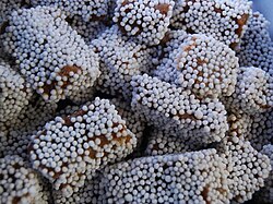
*[[Almora]] – Almora (famous for its [[bal mithai]] candy) is considered the cultural capital of Kumaon.<ref name="sweet">{{cite news|last1=Pant|first1=Rajshekhar|title=The Sweet Tooth Of Kumaon|url=http://www.thecitizen.in/index.php/NewsDetail/index/9/6381/The-Sweet-Tooth-Of-Kumaon|accessdate=22 July 2017|work=The Citizen|date=4 January 2016|archive-date=24 July 2017|archive-url=https://web.archive.org/web/20170724132945/http://www.thecitizen.in/index.php/NewsDetail/index/9/6381/The-Sweet-Tooth-Of-Kumaon|url-status=dead}}</ref> | |||
[[File:Bal mithai.jpg|thumb|[[Bal Mithai]] originated in [[Almora]], and now has become a symbol of Kumaoni cuisine.]] | |||
*Nainital – Nainital is by far the most well known tourist destination of Kumaon. The city has played a major role in exporting the Kumaoni culture to the rest of India.<ref>{{cite web|url=https://www.makemytrip.com/travel-guide/nainital/culture.html|title=[untitled]|publisher=MakeMyTrip|website=www.makemytrip.com|archive-url=https://web.archive.org/web/20151008013536/http://www.makemytrip.com/travel-guide/nainital/culture.html|archive-date=8 October 2015|url-status=dead}} {{dead link|date=May 2025}}</ref> | |||
[[File:Nainital lake in the morning.jpg|thumb|Naini dwellers in the morning]] | [[File:Nainital lake in the morning.jpg|thumb|Naini dwellers in the morning]] | ||
*Pithoragarh | *Pithoragarh – The city is known for its distinctive and unique culture. It has been one of the major hubs of Kumaoni culture and is the largest city in the hills of Kumaon.<ref>{{cite web |url=https://pithoragarh.nic.in/culture-heritage/#:~:text=The%20fairs%20of%20Pithoragarh%20are,fairs%20are%20primarily%20trade%20fairs. |title = Culture & Heritage {{!}} District Pithoragarh, Government of Uttarakhand {{!}} India}}</ref> | ||
*Champawat – Also known as Kali Kumaon, Champawat is the root of Kumaoni culture. It is from this place Kumaon got its name.<ref>{{cite web |url=https://champawat.nic.in/about-district/ |title = Champawat : KALI KUMAON {{!}} Champawat {{!}} India}}</ref> | |||
*Bageshwar – Bageshwar is known as "Kumaok Kashi" (Kumaon's [[Varanasi|Kashi]]), because of the holy [[Saryu]] flowing through it. Bageshwar is the home to the largest Kumaoni fair "Uttarayini".<ref>{{cite book|last1=Walton|first1=H. G.|title=Almora: A Gazetter|date=1911|publisher=The Government Press, United Provinces|location=Allahabad|page=Appendix XXIV}}</ref> | |||
*Haldwani – Though it is situated in Bhabhar, Haldwani has played a very significant role in shaping Kumaon's history and culture. It is Kumaon's largest city and has recently become a hub of artists, who are promoting Kumaoni language and culture.<ref>{{cite web |url=https://www.haldwani.co.in/art-culture-haldwani.php |title = Haldwani - Haldwani Uttarakhand, City Guide, Travel, News, Hotels, Culture, People, Fairs, Festivals, Photographs, History, Matrimony, Education, Business, Industries, Directory, Discussion Forum - A Complete Haldwani Guide}}</ref> | |||
*Rudrapur – Rudrapur is undoubtedly Kumaon's most cosmopolitan city, with a significant presence of Punjabi, Bengali and other migrants. However, Kumaonis form a large part of the city. Rudrapur is known as Kumaon's Financial Capital.<ref>{{cite web |url=https://usnagar.nic.in/kumaoni-culture-chachri-chapeli-was-presented-by-swaramayi-academy-rudrapur-on-the-main-stage-under-the-us-carnival/ |title = Kumaoni Culture Chachri, Chapeli was presented by Swaramayi Academy Rudrapur on the main stage Under the US Carnival {{!}} District UdhamSinghNagar, Government Of Uttarakhand {{!}} India}}</ref> | |||
==Religious significance== | |||
[[File:Sarju Aarti at Bageshwar (Cropped).jpg|thumb|Aarti at Sarju Ghat, [[Bageshwar]]]] | |||
In Kumaon, every peak, lake or mountain range is somehow or the other connected with some [[myth]] or the name of a god or goddess, ranging from those associated with the [[Shaiva]], [[Shakta]] and [[Vaishnava]] traditions, to local gods like Bambai Nath Swami, Haim, Saim, Golu, Nanda, Sunanda, Chhurmal, Kail Bisht, Bholanath, Gangnath, Airi and Chaumu. Referring to the rich religious myths and lores associated with Kumaon, E. T. Atkinson has said, "To the beliefs of the great majority of [[Hindus]], the Kumaon is what [[Palestine (region)|Palestine]] is to the Christians".<ref>{{cite book |last1=Pāṇḍe |first1=Girijā |last2=Geijerstam |first2=Jan af |title=Tradition and Innovation in the History of Iron Making: An Indo-European Perspective |date=2002 |publisher=The University of Michigan |isbn=978-81-86246-19-1 |page=354 |url=https://books.google.com/books?id=n4vtAAAAMAAJ&q=palestine+Atkinson |quote=E. T. Atkinson has said: " To the beliefs of the great majority of Hindus, the Kumaon Himalaya is what Palestine is to the Christian."}}</ref> | |||
==Economy== | |||
[[File:Terraced farming, paddy cultivation in Kumaon, Uttarakhand - 1.jpeg|thumb|Paddy cultivation in [[Pithoragarh district]]]] | |||
Kumaon is home to the financial capital of the state, Haldwani. Kumaon has the state's most commercial, economic and industrial activities specially in Bhabar and Terai regions. Agriculture also plays a huge role in Kumaoni | |||
economy. It employs a large percentage of Kumaoni population. | |||
=== Economic hubs === | |||
*Haldwani – Being the largest city of Kumaon, and the gateway of Kumaon, Haldwani is the financial centre of Kumaon. It is often dubbed as the financial capital, having the most commercial activity of the state. | |||
*Rudrapur – Rudrapur has established itself as a significant trading center within the Udham Singh Nagar district, which itself is a big trading center in Kumaon. The district exports include industrial as well as agricultural products, both of which are predominantly channelled from Rudrapur.<ref name=":7">{{Cite web|title=District Census Handbook-Udham Singh Nagar Part: XII-A|url=https://censusindia.gov.in/2011census/dchb/0512_PART_A_DCHB_UDHAM%20SINGH%20NAGAR.pdf|access-date=30 September 2020|website=Census India}}</ref> The Basmati rice from Rudrapur is among the top crop which is produced in the region.<ref name=":4">{{Cite web|title=नगर निगम रुद्रपुर, उधम सिंह नगर, उत्तराखण्ड – 263153|url=http://www.nagarnigamrudrapur.com/About.aspx|access-date=28 September 2020|website=www.nagarnigamrudrapur.com|archive-date=18 September 2020|archive-url=https://web.archive.org/web/20200918064409/http://nagarnigamrudrapur.com/About.aspx|url-status=dead}}</ref> Post the setup of State Infrastructure and Industrial Development Corporation of Uttarakhand Limited (SIDCUL), enhanced by the broad-gauge railway network in the area, Rudrapur has developed into an industrial city with its city limits expanding to accommodate new residential demands of the workers and professionals moving into the area.<ref name=":4" /> | |||
===Agriculture=== | |||
[[Basmati]] rice, Red rice, wheat, Ragi (Madua in Kumaoni), soybeans, groundnuts, coarse cereals, pulses, and [[oil seeds]] are the most widely grown crops. Fruits like apples, oranges, pears, peaches, lychees, and plums are widely grown and are important to the large food processing industry. Ramgarh, in Nainital District, specially, is famous for its fruits.{{citation needed|date=April 2025}} | |||
Tea is also cultivated in Berinag, Bhowali, Champawat and Lohaghat. Berinag tea being specially famous for its taste. Champawat's tea is sold by the name "Kumaon Black Tea". | |||
== Administrative Subdivisions == | |||
{| class="wikitable sortable" style="text-align: center;" | |||
|- | |||
! Code | |||
! District | |||
! Headquarters<ref name=knowindia>{{cite web | url = http://india.gov.in/knowindia/districts/andhra1.php?stateid=UA | title = Uttarakhand - Districts of India: Know India | publisher = National Portal of India | access-date = 4 April 2009 | archive-date = 19 February 2009 | archive-url = https://web.archive.org/web/20090219225233/http://india.gov.in/knowindia/districts/andhra1.php?stateid=UA | url-status = dead }}</ref> | |||
! Population ([[2011 Census of India|As of 2011]])<ref>{{cite web |url=http://updateox.com/india/district-wise-population-india-as-of-2011-census/ |url-status=dead |archive-url=https://web.archive.org/web/20110628204710/http://updateox.com/india/district-wise-population-india-as-of-2011-census |archive-date=28 June 2011 |title=District wise population in India as of 2011 census}}</ref> | |||
! Area (km<sup>2</sup>)<ref>{{cite web |url=http://india.gov.in/knowindia/districts/andhra1.php?stateid=UA |title=National Portal of India |access-date=10 February 2023 |archive-date=19 February 2009 |archive-url=https://web.archive.org/web/20090219225233/http://india.gov.in/knowindia/districts/andhra1.php?stateid=UA |url-status=dead }}</ref> | |||
! Density (/km<sup>2</sup>) | |||
! Map | |||
|- | |||
| AL || [[Almora district|Almora]] || [[Almora]] || 621,972 || 3,083 || 201 ||[[File:Almora in Uttarakhand (India).svg|100px]] | |||
|- | |||
| BA || [[Bageshwar district|Bageshwar]] || [[Bageshwar]] || 259,840 || 2,302 || 113 ||[[File:Bageshwar in Uttarakhand (India).svg|100px]] | |||
|- | |||
| CP || [[Champawat district|Champawat]] || [[Champawat]] || 259,315 || 1,781 || 146 ||[[File:Champawat in Uttarakhand (India).svg|100px]] | |||
|- | |||
| NA || [[Nainital district|Nainital]] || [[Nainital]] || 955,128 || 3,860 || 247 ||[[File:Nainital in Uttarakhand (India).svg|100px]] | |||
|- | |||
| PI || [[Pithoragarh district|Pithoragarh]] || [[Pithoragarh]] || 485,993 || 7,100 || 68 ||[[File:Pithoragarh in Uttarakhand (India).svg|100px]] | |||
|- | |||
| US || [[Udham Singh Nagar district|Udham Singh Nagar]] || [[Rudrapur, Uttarakhand|Rudrapur]] || 1,648,367 || 2,908 || 567 ||[[File:Udham Singh Nagar in Uttarakhand (India).svg|100px]] | |||
|- | |||
|colspan=3|Total || 4,230,615 || 21,034 || 201 || | |||
|} | |||
== Cities == | |||
{{Largest cities | |||
| country = Kumaon division | |||
| stat_ref = [[2011 Census of India]]<ref>{{cite web| url = http://www.censusindia.gov.in/2011-prov-results/paper2/data_files/India2/Table_3_PR_UA_Citiees_1Lakh_and_Above.pdf | title = Urban Agglomerations/Cities having population 1 lakh and above |work= Provisional Population Totals, Census of India 2011 | publisher = |accessdate = 7 July 2012 }}</ref><ref>{{cite web|title=Uttarakhand (India): Districts, Cities and Towns - Population Statistics|url=http://www.citypopulation.de/php/india-uttarakhand.php|archive-url=https://web.archive.org/web/20180323030632/http://www.citypopulation.de/php/india-uttarakhand.php|archive-date=23 March 2018|url-status=live}}</ref> | |||
| list_by_pop = | |||
| div_name = | |||
| div_link = List of districts of Uttarakhand{{!}}District | |||
== | |city_1 = Haldwani | ||
|div_1 = Nainital District{{!}}Nainital | |||
|pop_1 = 232,060 | |||
|city_2 = Rudrapur, Uttarakhand{{!}}Rudrapur | |||
|div_2 = Udham Singh Nagar District{{!}}Udham Singh Nagar | |||
|pop_2 = 154,485 | |||
|city_3 = Kashipur, Uttarakhand{{!}}Kashipur | |||
|div_3 = Udham Singh Nagar District{{!}}Udham Singh Nagar | |||
|pop_3 = 121,610 | |||
|city_4 = Pithoragarh | |||
|div_4 = Pithoragarh District{{!}}Pithoragarh | |||
|pop_4 = 56,044 | |||
|city_5 = Ramnagar, Nainital{{!}}Ramnagar | |||
|div_5 = Nainital District{{!}}Nainital | |||
|pop_5 = 54,787 | |||
== | |city_6 = Jaspur | ||
|div_6 = Udham Singh Nagar District{{!}}Udham Singh Nagar | |||
|pop_6 = 50,523 | |||
|city_7 = Kichha | |||
|div_7 = Udham Singh Nagar District{{!}}Udham Singh Nagar | |||
|pop_7 = 41,965 | |||
|city_8 = Nainital | |||
|div_8 = Nainital District{{!}}Nainital | |||
|pop_8 = 49,272 | |||
|city_9 = Almora | |||
|div_9 = Almora District{{!}}Almora | |||
|pop_9 = 48,456 | |||
|city_10 = Sitarganj | |||
|div_10 = Udham Singh Nagar District{{!}}Udham Singh Nagar | |||
|pop_10 = 29,965 | |||
=== | |city_11 = Bajpur | ||
|div_11 = Udham Singh Nagar District{{!}}Udham Singh Nagar | |||
|pop_11 = 25,524 | |||
|city_12 = Mukhani | |||
|div_12 = Nainital District{{!}}Nainital | |||
|pop_12 = 22,475 | |||
=== | |city_13 = Nagla | ||
|div_13 = Udham Singh Nagar District{{!}}Udham Singh Nagar | |||
|pop_13 = 22,258 | |||
|city_14 = Umru Khurd | |||
|div_14 = Udham Singh Nagar District{{!}}Udham Singh Nagar | |||
|pop_14 = 20,593 | |||
|city_15 = Gadarpur | |||
|div_15 = Udham Singh Nagar District{{!}}Udham Singh Nagar | |||
|pop_15 = 19,301 | |||
|city_16 = Ranikhet | |||
|div_16 = Almora District{{!}}Almora | |||
|pop_16 = 18,886 | |||
|city_17 = Tanakpur | |||
|div_17 = Champawat District{{!}}Champawat | |||
|pop_17 = 17,626 | |||
=== | |city_18 = Khatima | ||
|div_18 = Udham Singh Nagar District{{!}}Udham Singh Nagar | |||
|pop_18 = 15,093 | |||
|city_19 = Mahua Kheraganj | |||
|div_19 = Udham Singh Nagar District{{!}}Udham Singh Nagar | |||
|pop_19 = 12,584 | |||
|city_20 = Dineshpur | |||
|div_20 = Udham Singh Nagar District{{!}}Udham Singh Nagar | |||
|pop_20 = 11,343 | |||
}} | |||
==Languages== | ==Languages== | ||
{{Pie chart | {{Pie chart | ||
| thumb = right | | thumb = right | ||
| caption = Languages of Kumaon(2011 | | caption = Languages of Kumaon (2011)<ref name="census2011-C16" /> | ||
| label1 = [[Kumaoni language|Kumaoni]] | | label1 = [[Kumaoni language|Kumaoni]] | ||
| value1 = 46.8 | | value1 = 46.8 | ||
| Line 292: | Line 381: | ||
| label7 = Others | | label7 = Others | ||
| value7 = 4.3 | | value7 = 4.3 | ||
| color1 = | | color1 = Orange | ||
| color2 = | | color2 = blue | ||
| color3 = MediumVioletRed | | color3 = MediumVioletRed | ||
| color4 = LightGreen | | color4 = LightGreen | ||
| Line 300: | Line 389: | ||
| color7 = Yellow | | color7 = Yellow | ||
}} | }} | ||
The main language used in administration and education is [[Hindi]], which according to the 2011 census is the first language of well over a million of the region's inhabitants (mostly concentrated in the south). The major native language, however, is [[Kumaoni language|Kumaoni]], spoken by about 2 million people. In the southern districts there are also sizeable numbers of speakers of [[Punjabi language|Punjabi]], [[Urdu]] and [[Bengali language|Bengali]],<ref name="census2011-C16"/> while the two related languages of [[Buksa language|Buksa]] and [[Rana Tharu language|Rana Tharu]] are found in the southernmost Udham Singh Nagar district. The higher mountains in the north of Kumaon are home to the Sino-Tibetan [[Byangsi language|Byangsi]], [[Chaudangsi language|Chaudangsi]], [[Darmiya language|Darmiya]], [[Raji language|Raji]], [[Rawat language|Rawat]] and [[Rangas language|Rangas]] (the last now extinct).<ref name = "ethnologue2019">{{cite web|editor-last1 = Eberhard| editor-first1 = David M.| editor-last2 = Simons| editor-first2 = Gary F.| editor-last3 = Fennig| editor-first3 = Charles D.| year=2019|title=India – Languages|edition=22nd|website = Ethnologue|publisher=SIL International|url=https://www.ethnologue.com/country/IN/languages | archive-url = https://web.archive.org/web/20190401120331/https://www.ethnologue.com/country/IN/languages | archive-date = 1 April 2019}}</ref> | The main language used in administration and education is [[Hindi]], which according to the 2011 census is the first language of well over a million of the region's inhabitants (mostly concentrated in the south). The major native language, however, is [[Kumaoni language|Kumaoni]], spoken by about 2 million people. | ||
In the southern districts there are also sizeable numbers of speakers of [[Punjabi language|Punjabi]], [[Urdu]] and [[Bengali language|Bengali]],<ref name="census2011-C16" /> while the two related languages of [[Buksa language|Buksa]] and [[Rana Tharu language|Rana Tharu]] are found in the southernmost Udham Singh Nagar district. The higher mountains in the north of Kumaon are home to the Sino-Tibetan [[Byangsi language|Byangsi]], [[Chaudangsi language|Chaudangsi]], [[Darmiya language|Darmiya]], [[Raji language|Raji]], [[Rawat language|Rawat]] and [[Rangas language|Rangas]] (the last now extinct).<ref name="ethnologue2019">{{cite web|editor-last1 = Eberhard| editor-first1 = David M.| editor-last2 = Simons| editor-first2 = Gary F.| editor-last3 = Fennig| editor-first3 = Charles D.| year=2019|title=India – Languages|edition=22nd|website = Ethnologue|publisher=SIL International|url=https://www.ethnologue.com/country/IN/languages | archive-url = https://web.archive.org/web/20190401120331/https://www.ethnologue.com/country/IN/languages | archive-date = 1 April 2019}}</ref> | |||
The community radio station Kumaon Vani has been broadcasting over the region since 2010.<ref>{{Cite web|title = Kumaon Vani Community Radio - 90.4 MHz| date = 27 December 2017| url = https://www.teriin.org/project/kumaon-vani-community-radio-904-mhz|access-date = 16 January 2020}}</ref> | The community radio station Kumaon Vani has been broadcasting over the region since 2010.<ref>{{Cite web|title = Kumaon Vani Community Radio - 90.4 MHz| date = 27 December 2017| url = https://www.teriin.org/project/kumaon-vani-community-radio-904-mhz|access-date = 16 January 2020}}</ref> | ||
| Line 480: | Line 571: | ||
==See also== | ==See also== | ||
* [[Kumaoni people]] | |||
* [[List of Kumaonis]] | * [[List of Kumaonis]] | ||
* [[ | * [[Kumaoni language]] | ||
* [[ | * [[Garhwal division]] | ||
* | |||
==References== | |||
{{Reflist|2}} | |||
* ''A New History of Uttrakhand'' by Dr. Y. S. Kathoch | |||
==Further reading== | ==Further reading== | ||
* {{cite book|last=Kak|first=Manju|title=In the Shadow of the Devi Kumaon: Of a Land, a People, a Craft | * {{cite book|last=Kak|first=Manju|title=In the Shadow of the Devi Kumaon: Of a Land, a People, a Craft |year=2017|publisher=Niyogi Books |isbn=978-93-85285-67-7 }} | ||
* {{cite book|last=Oakley|first= E Sherman|title=Holy Himalaya; the religion, traditions, and scenery of Himalayan province (Kumaon and Garwhal)|url=https://archive.org/stream/holyhimalayareli00oaklrich#page/n7/mode/2up|year=1905|publisher=Oliphant Anderson & Ferrier, London}} | * {{cite book|last=Oakley|first= E Sherman|title=Holy Himalaya; the religion, traditions, and scenery of Himalayan province (Kumaon and Garwhal)|url=https://archive.org/stream/holyhimalayareli00oaklrich#page/n7/mode/2up|year=1905|publisher=Oliphant Anderson & Ferrier, London}} | ||
* {{cite book |author=Raja Rudradeva of Kumaon |editor=Haraprasada Shastri |title=Syanika sastra: or A Book on Hawking|url=https://archive.org/stream/syanikasatraorbo00rudruoft#page/n3/mode/2up|year=1910|publisher=Asiatic Society, Calcutta}} | * {{cite book |author=Raja Rudradeva of Kumaon |editor=Haraprasada Shastri |title=Syanika sastra: or A Book on Hawking|url=https://archive.org/stream/syanikasatraorbo00rudruoft#page/n3/mode/2up|year=1910|publisher=Asiatic Society, Calcutta}} | ||
== | ;Folklore: | ||
{{ | * {{cite book |last=Минаев |first=Иван Павлович |date=1968 |title=Индийские сказки и легенды, собранные в Камаоне в 1875 году И.П. Минаевым |location=Мoskva |publisher=Наука |orig-year=1877 |language=RU}} | ||
* '' | * {{cite book|last=Upreti|first=Ganga Dutt|title=Proverbs & folklore of Kumaon and Garhwal|url=https://archive.org/stream/cu31924089930774#page/n7/mode/2up|year=1894|publisher=Lodiana Mission Press}} | ||
* Oakley, E. S.; Gairola, Tara Dutt. ''Himalayan Folklore: Kumaon And West Nepal''. Kathmandu, Nepal: Ratna Pustak Bhandar, 1977 [1935]. | |||
* {{cite book |last=Budhwar |first=Kusum |title=Where gods dwell: central Himalayan folktales and legends |location=New Delhi |publisher=Penguin Books |date=2010 |isbn=9780143066026}} | |||
* {{cite book |first=Prabha |last=Pant |title=Echoes of Kumaon: Myths Magic And Mountain Tales |translator=Shweta Awasthi |publisher=BFC Publications |date=2025 |isbn=9789371205474}} | |||
== External links == | == External links == | ||
| Line 501: | Line 598: | ||
{{Kumaon}} | {{Kumaon}} | ||
{{Uttarakhand}} | {{Uttarakhand}} | ||
{{Historical regions of North India|state=expanded}} | |||
{{coord|29.6|79.7|type:adm2nd_region:IN|display=title}} | {{coord|29.6|79.7|type:adm2nd_region:IN|display=title}} | ||
{{Authority control}} | {{Authority control}} | ||
| Line 510: | Line 606: | ||
[[Category:Kumaon division| ]] | [[Category:Kumaon division| ]] | ||
[[Category:Divisions of Uttarakhand]] | [[Category:Divisions of Uttarakhand]] | ||
[[Category:History of Kumaon| ]] | |||
Latest revision as of 20:21, 29 March 2026
Kumaon division
Kumāũ Kurmānchal, Manaskhand | |
|---|---|
    _view_of_Himalayan_foothills,_Uttarakhand_India_November_2013.jpg)    Clockwise from top: View of Trishul peaks from Ranikhet, Kali river at Jauljibi,
View of Purnagiri hills from Tanakpur, Johar Valley, Naini Lake, Jageshwar | |
| Nickname: The Home of Gods[1] | |
 Location in India | |
| Country |  India India |
| Established | 1815[2] |
| Headquarter | Nainital |
| Largest city | Haldwani |
| Districts | |
| Government | |
| • Type | Division |
| • Commissioner | Deepak Rawat IAS[3] |
| Area | |
| • Total | 21,035 km2 (8,122 sq mi) |
| Population | |
| • Total | 4,228,998[4] |
| • Density | 201.04/km2 (520.7/sq mi) |
| Demonym | Kumaoni |
| Languages | |
| • Official | Hindi |
| • Native | Kumaoni, Nepali, Tharu(Buksari), RungLo, Kauravi |
| Ethnicity | |
| • Ethnic groups | Kumaoni, Shaukas, Rungs, Bhotiyas, Tharu, Bhoksa |
| Time zone | UTC+5:30 (IST) |
| Vehicle registration | UK |
| Highest peak of Kumaon Division | Hardeol 7,151 m (23,461 ft) |
| Lowest elevation of Kumaon Division | Sharda Sagar Reservoir (190 m)[5] |
| Largest lake | Bhimtal |
| Website | http://kumaon.gov.in/ |
Kumaon (/ˈkɛmɔːʊ/; Kumaoni: Kumāũ, pronounced [kʊmɔːũː]; historically romanised as Kemāon[6][7]) is a revenue and administrative division in the Indian state of Uttarakhand. It spans over the eastern half of the state and is bounded on the north by Tibet Autonomous Region of China, on the east by Nepal, on the south by the state of Uttar Pradesh, and on the west by Garhwal Division. Kumāon comprises six districts of the state: Almora, Bageshwar, Champawat, Nainital, Pithoragarh and Udham Singh Nagar.
Historically known as Manaskhand and Kurmanchal, the Kumaon region has been ruled by several dynasties over the course of its history; most notably the Katyuris and the Chands.
The people of Kumaon are known as Kumaonis and speak the Kumaoni language. Kumaon is home to a famous Indian Army regiment, the Kumaon Regiment of IHR within the Indian Republic. The hill town Nainital is its administrative centre and this is where the Uttarakhand high court is located.[8] Other notable hill towns of Kumaon are Almora, Ranikhet, Pithoragarh, Champawat and Bageshwar. However, all the major cities of the region like Haldwani, Rudrapur, Kashipur, Ramnagar and Tanakpur are concentrated in the southern plain areas of Bhabar and Terai.
Etymology[edit | edit source]
The Kumaon region is mentioned in the Skanda Purana as Manaskhand. Kumaon is believed to have been derived from Kurmanchal, meaning the land of Kurma (the tortoise avatar of Vishnu, the preserver deity in Hinduism).[9][10][11]
According to another theory, the word Kumaon can be traced back to the 5th century BC during the time of Vedic period. The Khasas, Assyrians left their homeland Kummaoh, on the banks of river Euphrates, and settled in the northern part of India.[9][10][11]
During this time of the British control of the region, between 1815 and 1857, it was also known as Kemaon.[6][7][12]
Geography[edit | edit source]

The Kumaon[13] region consists of a large Himalayan tract, together with two submontane strips called the Terai and the Bhabar. The submontane strips were up to 1850 an almost impenetrable forest, given up to wild animals; but after 1850 the numerous clearings attracted a large population from the hills, who cultivated the rich soil during the hot and cold seasons, returning to the hills in the rains. The rest of Kumaon is a maze of mountains, part of the Himalaya range, some of which are among the loftiest known. In a tract not more than 225 km in length and 65 km in breadth there are over thirty peaks rising to elevations exceeding 5,500 m (18,000 ft).[14]


Rivers such as Gori, Dhauli, and Kali rise chiefly in the southern slope of the Tibetan watershed north of the loftiest peaks, amongst which they make their way down valleys of rapid declivity and extraordinary depth. The principal is the Sharda (Kali Ganga), the Pindari and Kailganga, whose waters join the Alaknanda.[14] The river Sharda (Kali Ganga) forms the international boundary between India and Nepal. The pilgrim route currently used to visit Kailash-Mansarovar goes along this river and crosses into Tibet at Lipu Lekh pass.
The chief trees are the chir pine, Himalayan cypress, pindrow fir, alder, sal and saindan. Limestone, sandstone, slate, gneiss and granite constitute the principal geological formations. Mines of iron, copper, gypsum, lead and asbestos exist, but they are not thoroughly worked. Except in the submontane strips and deep valleys, the climate is mild. The rainfall of the outer Himalayan range, which is first struck by the monsoon, is double that of the central hills, in the average proportion of 2000 mm to 1000 mm. No winter passes without snow on the higher ridges, and in some years, it is universal throughout the mountain tract. Frosts, especially in the valleys, are often severe.[14]
History[edit | edit source]
Prehistoric dwellings and Stone Age implements have been discovered in Almora and Nainital districts. Initially settled by Kols,[15] the region witnessed successive waves of Kiratas, Khasas, and Indo-Sythians. Kunindas were the first rulers of the region. They were followed by the Katyuri kings of Khasas origin[16] who controlled the region from 700 to 1200 AD.[10]
Around 1100–1200 AD, after Katyuri kingdom disintegration, Kurmanchal was divided into eight different principalities: Baijnath-Katyur, Dwarhat, Doti, Baramandal, Askot, Sira, Sora, Sui. Around 1581 AD, under Rudra Chand, the whole region was brought together again as Kumaon.

Kumaon Kingdom[edit | edit source]
The Kumaon Kingdom was a historical Himalayan state located in the eastern part of present-day Uttarakhand, India. It existed as an independent political entity for several centuries and played an important role in the regional history of the Central Himalayas. The kingdom covered much of the Kumaon region, including areas around Almora, Champawat, Nainital, and Bageshwar. Its geography consisted of mountainous terrain, river valleys, and forested areas, which influenced its defense, economy, and settlement patterns. Agriculture, pastoralism, and trade formed the economic base of the kingdom. Land revenue systems and local administrative units were used to govern rural areas.[16] who controlled the region from 700 to 1200 AD.[10]
Culturally, the kingdom contributed significantly to the development of Kumaoni language, folklore, religious traditions, and temple architecture. Hinduism was the dominant religion, with strong influences of Shaivism and Shaktism, and the region became known for its temples and pilgrimage centers.[16] who controlled the region from 700 to 1200 AD.[10]
The Kumaon Kingdom maintained a distinct political and cultural identity despite conflicts and interactions with neighboring Himalayan states. Its independence ended in 1791, after which the region came under external rule. Following the Anglo-Nepalese War (1814–1816), Kumaon was incorporated into British India.[16] who controlled the region from 700 to 1200 AD.[10]
Katyuri Raj[edit | edit source]

The Katyuri dynasty was a ruling Hindu dynasty of Khasha origin[16] that was founded by Vashudev Katyuri. They established their kingdom and called it Kurmanchal kingdom, dominating lands of varying extent from the 'Katyur' (modern day Baijnath) valley in Kumaon, between 7th and 11th centuries AD, and establishing their capital at Baijnath in Bageshwar district, which was then known as Kartikeyapura and lies in the centre of 'Katyur' valley. Brahmadev mandi in Kanchanpur District of far western Nepal was established by Katyuri king Brahma Deo. At their peak, the kurmanchal kingdom of Katyuri kings was extended from Sikkim in the east to Kabul, Afghanistan in the west, before fragmenting into numerous principalities by the 12th century.
It is believed that from king Dham Deo and Bir Deo the downfall of this powerful dynasty began. Birdeo used to collect heavy taxes and forced his people to work as his slaves, King Birdeo teased his subjects by his tyranny to the extent that he forcibly married his own maternal aunt Tila. It is said that the Kumaoni folk song Mami tile dharo bola became popular from that very day. after death of Birdeo the kingdom was divided between his eight sons and they were able to form their different small kingdoms in the region for a short period of time until Chands emerged in the region defeating most of katyuri principalities and united Kurmanchal again as Kumaon.[17][full citation needed]
The Rajwar dynasty of Askot in Pithoragarh, was set up in 1279 AD, by a branch of the Katyuri kings, headed by Abhay Pal Deo, who was the grandson of Katyuri king Brahma Deo. The dynasty ruled the region until it became part of the British Raj through the treaty of Sighauli in 1816.
Chand Raj[edit | edit source]

The Chand dynasty was established by Som Chand in the 10th century,[18] by displacing the Katyuri Kings, who had been ruling the area from the 7th century AD. He continued to call his state Kurmanchal and established its capital in Champawat in Kali Kumaon called so, due to its vicinity to river Kali. Many temples built in this former capital city, during the 11th and 12th century exist today, this includes the Baleshwar and Nagnath temples.

One of the most powerful rulers of Chand dynasty was Baz Bahadur (1638–1678 AD), who met Shahjahan in Delhi, and in 1655 joined forces with him to attack Garhwal, which was then under the King Pirthi Sah. Baz Bahadur subsequently captured the Terai region including Dehradun, which was thus separated from the Garhwal kingdom. Baz Bahadur extended his territory east to Karnali river, later Baz Bahadur invaded Tibet and captured several forts including a Hindu pilgrim Kailash Manasarovar.[19][20][21][22][23][24][25] he also built the Golu Devata Temple, at Ghorakhal, near Bhimtal,[18] after Lord Golu, a general in his army, who died valiantly in battle.[26] He also built the famous Bhimeshwara Mahadev Temple at Bhimtal.[27]
Towards the end of the 17th century, Chand kings again attacked the Garhwal kingdom, and in 1688, Udyot Chand erected several temples at Almora, including Tripur Sundari, Udyot Chandeshwar, and Parbateshwar. To mark his victory over Garhwal and Doti, the Parbateshwar temple was renamed twice, to become the present Nanda Devi temple.[28] Later, Jagat Chand (1708–1720) defeated the Raja of Garhwal and pushed him away from Srinagar (in Uttarakhand, not to be confused with the capital of present-day Indian Kashmir), and his kingdom was given to a Brahmin.[29]
Nepalese invasion and its defeat[edit | edit source]

In the latter half of the 18th century, the power of Kumaon was on decline, as the king Mahendra Chand was unable to properly administer the country. After the fall of Doti, the Kingdom of Nepal decided to again invade over Kumaon. The Gorkha forces, under the leadership of Amar Singh Thapa crossed the kali river, and reached the outskirts of Almora via Sor and Gangoli. After facing tough resistance by King Mahendra Chand's uncle who was leading the army, and retreating temporarily, the Gorkha's returned again and in the ensuing battle Mahendra Chand's uncle was killed. Hearing about his uncle's death, Mahendra Chandra became frightened and fled to the plains. Kumaon was annexed to the Kingdom of Nepal in 1790.[30]
The Gorkha rule over Kumaon lasted for 24 years. The only architectural advancements during the period was a road connecting kali river to Srinagar via Almora. The Gorkha rule over Kumaon is said to have been cruel and barbaric. The Gorkha's only thought of Kumaon and Garwhal (which was conquered some years after the invasion of Kumaon) as frontier states and so proper administration was not practiced. Almora was the largest town of Kumaon during the Gorkha period, and is estimated to have about 1000 houses.
After the Gorkhas started meddling in the territories of Oudh, the Nawab of Oudh, who was then a suzerain of the British Empire, asked for their help, thus paving way for the Anglo-Nepalese War of 1814. The British forces under Colonel Nicholas, consisting of about forty five hundred men and six pounder guns, entered Kumaon through Kashipur and conquered Almora on 26 April 1815. On the same day, Chandra Bahadur Shah, one of the principle Gurkha chiefs, sent a flag of truce, requesting to end hostilities in the region. A negotiation was brought up the following day, under which the Gurkhas agreed to leave the Country, and all its fortified places. The war ended with Nepal signing the Treaty of Sugauli in 1816, under which, Kumaon officially became a British territory.
British Raj[edit | edit source]

The region was annexed by the British East India Company in 1815, and the Kumaon region was joined with the eastern half of the Garhwal region as a chief-commissionership on the non-regulation system, also known as the Kumaon Province.[31][2] It was part of the Ceded and Conquered Provinces.[32] It was governed for seventy years by three administrators, Mr. Traill, Mr. J. H. Batten and Sir Henry Ramsay.
There was widespread opposition against British rule in various parts of Kumaon. The Kumaoni people especially Champawat District rose in rebellion against the British during the Indian Rebellion of 1857 under the leadership of the members like Kalu Singh Mahara.[33] In 1891 the division was composed of the three districts of Kumaon, Garhwal and the Tarai; but the two districts of Kumaon and the Tarai were subsequently redistributed and renamed after their headquarters, Nainital and Almora.
The area received international attention after the publication of Man-Eaters of Kumaon, by Jim Corbett, the noted hunter and conservationist, describing the author's trials seeking out and killing man-eating tigers. Animals like the Champawat Tiger and the Chowgarh Tigers plagued the area for many years, with the former estimated to have killed over four hundred humans by herself, in Nepal and then Kumaon, in the years 1920–1928.
Mahatma Gandhi's advent sounded a death knell for the British in Kumaon. People now aware of the excesses of British Raj became defiant of it and played an active part in the Indian Struggle for Independence. While staying in Kumaon for 12 days, recovering from the rigors of imprisonment, Gandhi wrote Anashakti Yoga, his commentary on the Gita.[34]
In these hills, nature's hospitality eclipses all men can do. The enchanting beauty of Himalayas, their bracing climate and the soothing green that envelopes you leaves nothing more to be desired. I wonder whether the scenery of these hills and the climate are surpassed, if equalled, by any of the beauty spots anywhere of the world. After having been nearly three weeks in Almora hills, I am more than ever amazed why our people need go to Europe in search of health.
— Mahatma Gandhi, Almora Impressions, Young India (11 July 1929)[35]
Gandhi was revered in these parts and on his call the struggle of Salam Saliya Satyagraha led by Ram Singh Dhoni was started which shook the very roots of British rule in Kumaon.[36] Many people died in the Saalam Satyagraha due to police brutality. Gandhi named it the Bardoli of Kumaon an allusion to the Bardoli Satyagrah. Many Kumaonis also joined the Indian National Army led by Netaji Subhash Chandra Bose.
Independent India[edit | edit source]
After India became independent in 1947, United Provinces were converted into the newly formed Indian state of Uttar Pradesh. The princely state of Tehri Garhwal joined the Indian Union in 1949, and became a district under the Kumaon division. Three new districts viz. Pithoragarh from Almora, Chamoli from Garhwal and Uttarkashi from Tehri Garhwal were created in 1960. A new revenue division, named Uttarakhand division, was carved out from these three districts of Kumaon division.
The year 1969 saw major administrative reforms in these hilly regions of Uttar Pradesh, and a new Garhwal division, with its headquarter in Pauri, was formed with the districts of Tehri Garhwal and Garhwal from Kumaon division, and Uttarkashi and Chamoli from Uttarakhand division. The Uttarakhand division too was disestablished the same year, and the remaining district of Pithoragarh was brought back to Kumaon division, hence giving it its present size.
Three new districts were created in the 90's, taking the total number of districts in the division to six. Udham singh nagar from Nainital in 1995, and Bageshwar from Almora and Champawat from Pithoragarh in 1997. As a result of the largely peaceful Uttarakhand movement, the state of Utarranchal was carved out of Uttar Pradesh in 2000; this state's name was changed to Uttarakhand in 2007.[37] Two new districts, Ranikhet from Almora and Didihat from Pithoragarh, were announced in 2011 by the then Chief minister of Uttarakhand, Ramesh Pokhriyal, but the districts never came into existence because no official notification was ever released.
Culture[edit | edit source]
Traditional attire[edit | edit source]
_(2).jpg)


Pichaura (पिछोङा) is a traditional attire worn by married Kumaoni women generally for religious occasions, marriage, and other rituals. Traditionally handmade using vegetable dyes, Pichhauras are available in red and saffron. Local designs made in Almora, Haldwani and other parts of Kumaon use silk fabric and accessories made of pearl. It is also contemporarily made using machines. In recent years its popularity has seen a rise, especially in Kumaoni diaspora in other states and countries.[38]
Kumaoni men wear a Kumaoni cap, which is of black colour. However, during festivals, especially during Kumauni Holi the cap becomes white in colour.[38]

The Bhotiya community, also known as Kumaoni Bhotiya, is a minority indigenous group in the Kumaon region of Uttarakhand. Traditionally inhabiting the high-altitude areas, the community has historically been involved in trans-Himalayan trade, animal husbandry, and agriculture. Their cultural practices, dress, and festivals reflect influences from both Himalayan and Tibetan traditions.[38]
Folk Art[edit | edit source]
Aipan is the most famous folk art of Kumaon. In recent times its popularity has grown. Aipan is not only an important folk art of Kumaoni community but other ethnic groups of Kumaon, like Shaukas and Rungs, as well. Hence it also acts as a cultural link between different ethnic communities of Kumaon, therefore has significant importance.
Among the prominent local crafts is wood carving known as Likhai, which appears most frequently in the ornately decorated temples and at the doors and windows of local houses. Intricately carved designs of floral patterns, deities, and geometrical motifs also decorate the doors, windows, ceilings, and walls of village houses. Paintings and murals are used to decorate both houses and temples.
Jyuti patta is a class of water color paintings done on rituals, called Jyuti. Some scholars also consider Jyuti to be synonymous with the wod mother of the world. To give concrete form to the deity, two-dimensional geometry is given expression in the form of frescoes. This is a geometric or decorative semi-graphic structure in which different colours and symbols are used. This structure called Jyuti also gets a new dimension by the use of ochre or biswar of Tepan. Jyunti is prepared on the surface of wall or paper and the composition is given with cotton and a brush of limiter. In this artform, various qualities of a specific deity are shown.
Folk dances[edit | edit source]
Many classical dance forms and folk art are practised in the Kumaon. Some well-known dances include Hurkiya Baul,[39] Jhora-Chanchri and Chholiya.[40] Music is an integral part of the Kumaoni culture. Popular types of folk songs include Mangal and Nyoli.[41] These folk songs are played on instruments including dhol, damau, turri, ransingha, dholki, daur, thali, bhankora, mandan and mashakbaja. A famous Kumaoni folk song is Bedu Pako Baro Masa. Music is also used as a medium through which the gods are invoked. Jagar is a form of spirit worship in which the singer, or Jagariya, sings a ballad of the gods, with allusions to great epics, like Mahabharat and Ramayana, that describe the adventures and exploits of the god being invoked.


Kumaoni Ramleela is the oldest in the world. It is 150 years old, due to which UNESCO has declared it world's longest-running opera. In addition, the Kumaoni Ramleela is now a part of the World Cultural Heritage List.[42]
Harela is a kumaoni festival hypothesized to date back to the indigenous population. 10–11 days before the Sankranti of Shravan, a bed is made by adding soil in bamboo pots etc. Grains grown during the rainy season like paddy, maize, urad etc. are sown, this is called Hariyala. Harakali Mahotsav, Idols of Gauri Maheshwar, Ganesha and Karkitkeya are made from clay, coloured in them and worshiped with various fruits, flowers, dishes and sweets in a bed of greenery on the night of the month of Sanat. On the second day, the Harela of Uttarang Puja is placed on the head. Sisters and daughters-in-law apply tilak and tilak and put Harela on their heads. They are given gifts.

Kumaoni holi is the historical and cultural celebration of the Hindu festival of Holi. It is one of the most important festivals for the Kumauni people as it signifies not only the victory of good over evil but also end of the winter season and the start of the new sowing season which holds great importance for this agricultural community of the North Indian Himalayas. The uniqueness of the Kumaoni Holi lies in its being a musical affair, whatever its form, be it the Baithki Holi, the Khari Holi and the Mahila Holi all of which start from Basant Panchmi. This results in the festivities of Holi lasting for almost two months in Kumaon.[43]
The Baithki Holi and Khari Holi are unique in that the songs on which they are based have a combination of melody, fun, and spiritualism. These songs are essentially based on classical ragas. Baithki Holi is also known as Nirvan Ki Holi or Holi of Salvation.
Almora Dussehra is a regional variant of Dussehra, dating back to 1936. It is distinct for burning fifteen distinct effigies, each representing the members of the Hindu mythological villain Ravana's entire bloodline. The effigies are all ornate and exquisitely designed. They are paraded through the city of Almora before finally being set on fire to symbolise the triumph of good over evil.
Phool-Dei is a folk festival which welcomes the spring season in the state. The festival is celebrated on the first day of the Hindu month, Chaitra. In some places, the festival is celebrated as carnival and the celebration goes on for a month. The term 'Dei' refers to a ceremonial pudding which is the key food in this festival that is made from jaggery. White flour and curd are also offered. Young children gather together and go to every house in their village/towns with plates full of rice, jaggery, coconut, green leaves, and flowers. In return, they are presented with blessings and gifts like sweets, jaggery, and money. The wishing and blessing part also include placing flowers and rice on the doorsteps of the houses by the children. People of village sing and dance on their folk songs to celebrate the festival of spring along with exchanging wishes for well-being and prosperity of their family and relatives.
Cultural hubs[edit | edit source]
- Almora – Almora (famous for its bal mithai candy) is considered the cultural capital of Kumaon.[44]

- Nainital – Nainital is by far the most well known tourist destination of Kumaon. The city has played a major role in exporting the Kumaoni culture to the rest of India.[45]

- Pithoragarh – The city is known for its distinctive and unique culture. It has been one of the major hubs of Kumaoni culture and is the largest city in the hills of Kumaon.[46]
- Champawat – Also known as Kali Kumaon, Champawat is the root of Kumaoni culture. It is from this place Kumaon got its name.[47]
- Bageshwar – Bageshwar is known as "Kumaok Kashi" (Kumaon's Kashi), because of the holy Saryu flowing through it. Bageshwar is the home to the largest Kumaoni fair "Uttarayini".[48]
- Haldwani – Though it is situated in Bhabhar, Haldwani has played a very significant role in shaping Kumaon's history and culture. It is Kumaon's largest city and has recently become a hub of artists, who are promoting Kumaoni language and culture.[49]
- Rudrapur – Rudrapur is undoubtedly Kumaon's most cosmopolitan city, with a significant presence of Punjabi, Bengali and other migrants. However, Kumaonis form a large part of the city. Rudrapur is known as Kumaon's Financial Capital.[50]
Religious significance[edit | edit source]
.jpg)
In Kumaon, every peak, lake or mountain range is somehow or the other connected with some myth or the name of a god or goddess, ranging from those associated with the Shaiva, Shakta and Vaishnava traditions, to local gods like Bambai Nath Swami, Haim, Saim, Golu, Nanda, Sunanda, Chhurmal, Kail Bisht, Bholanath, Gangnath, Airi and Chaumu. Referring to the rich religious myths and lores associated with Kumaon, E. T. Atkinson has said, "To the beliefs of the great majority of Hindus, the Kumaon is what Palestine is to the Christians".[51]
Economy[edit | edit source]

Kumaon is home to the financial capital of the state, Haldwani. Kumaon has the state's most commercial, economic and industrial activities specially in Bhabar and Terai regions. Agriculture also plays a huge role in Kumaoni economy. It employs a large percentage of Kumaoni population.
Economic hubs[edit | edit source]
- Haldwani – Being the largest city of Kumaon, and the gateway of Kumaon, Haldwani is the financial centre of Kumaon. It is often dubbed as the financial capital, having the most commercial activity of the state.
- Rudrapur – Rudrapur has established itself as a significant trading center within the Udham Singh Nagar district, which itself is a big trading center in Kumaon. The district exports include industrial as well as agricultural products, both of which are predominantly channelled from Rudrapur.[52] The Basmati rice from Rudrapur is among the top crop which is produced in the region.[53] Post the setup of State Infrastructure and Industrial Development Corporation of Uttarakhand Limited (SIDCUL), enhanced by the broad-gauge railway network in the area, Rudrapur has developed into an industrial city with its city limits expanding to accommodate new residential demands of the workers and professionals moving into the area.[53]
Agriculture[edit | edit source]
Basmati rice, Red rice, wheat, Ragi (Madua in Kumaoni), soybeans, groundnuts, coarse cereals, pulses, and oil seeds are the most widely grown crops. Fruits like apples, oranges, pears, peaches, lychees, and plums are widely grown and are important to the large food processing industry. Ramgarh, in Nainital District, specially, is famous for its fruits.[citation needed]
Tea is also cultivated in Berinag, Bhowali, Champawat and Lohaghat. Berinag tea being specially famous for its taste. Champawat's tea is sold by the name "Kumaon Black Tea".
Administrative Subdivisions[edit | edit source]
| Code | District | Headquarters[54] | Population (As of 2011)[55] | Area (km2)[56] | Density (/km2) | Map |
|---|---|---|---|---|---|---|
| AL | Almora | Almora | 621,972 | 3,083 | 201 | .svg)
|
| BA | Bageshwar | Bageshwar | 259,840 | 2,302 | 113 | .svg)
|
| CP | Champawat | Champawat | 259,315 | 1,781 | 146 | .svg)
|
| NA | Nainital | Nainital | 955,128 | 3,860 | 247 | .svg)
|
| PI | Pithoragarh | Pithoragarh | 485,993 | 7,100 | 68 | .svg)
|
| US | Udham Singh Nagar | Rudrapur | 1,648,367 | 2,908 | 567 | .svg)
|
| Total | 4,230,615 | 21,034 | 201 | |||
Cities[edit | edit source]
| Rank | District | Pop. | Rank | District | Pop. | ||||
|---|---|---|---|---|---|---|---|---|---|
| 1 | Haldwani | Nainital | 232,060 | 11 | Bajpur | Udham Singh Nagar | 25,524 | ||
| 2 | Rudrapur | Udham Singh Nagar | 154,485 | 12 | Mukhani | Nainital | 22,475 | ||
| 3 | Kashipur | Udham Singh Nagar | 121,610 | 13 | Nagla | Udham Singh Nagar | 22,258 | ||
| 4 | Pithoragarh | Pithoragarh | 56,044 | 14 | Umru Khurd | Udham Singh Nagar | 20,593 | ||
| 5 | Ramnagar | Nainital | 54,787 | 15 | Gadarpur | Udham Singh Nagar | 19,301 | ||
| 6 | Jaspur | Udham Singh Nagar | 50,523 | 16 | Ranikhet | Almora | 18,886 | ||
| 7 | Kichha | Udham Singh Nagar | 41,965 | 17 | Tanakpur | Champawat | 17,626 | ||
| 8 | Nainital | Nainital | 49,272 | 18 | Khatima | Udham Singh Nagar | 15,093 | ||
| 9 | Almora | Almora | 48,456 | 19 | Mahua Kheraganj | Udham Singh Nagar | 12,584 | ||
| 10 | Sitarganj | Udham Singh Nagar | 29,965 | 20 | Dineshpur | Udham Singh Nagar | 11,343 | ||
Languages[edit | edit source]
The main language used in administration and education is Hindi, which according to the 2011 census is the first language of well over a million of the region's inhabitants (mostly concentrated in the south). The major native language, however, is Kumaoni, spoken by about 2 million people.
In the southern districts there are also sizeable numbers of speakers of Punjabi, Urdu and Bengali,[4] while the two related languages of Buksa and Rana Tharu are found in the southernmost Udham Singh Nagar district. The higher mountains in the north of Kumaon are home to the Sino-Tibetan Byangsi, Chaudangsi, Darmiya, Raji, Rawat and Rangas (the last now extinct).[59]
The community radio station Kumaon Vani has been broadcasting over the region since 2010.[60]
| Kumaon division: mother-tongue of population, according to the 2011 Indian Census.[4] | |||||||||
|---|---|---|---|---|---|---|---|---|---|
| Mother tongue code | Mother tongue | District | Kumaon division | ||||||
| Pithoragarh | Bageshwar | Almora | Champawat | Nainital | Udham Singh Nagar | People | Percentage | ||
| 002007 | Bengali | 414 | 67 | 555 | 519 | 4,174 | 129,537 | 135,266 | 3.2% |
| 006102 | Bhojpuri | 1,654 | 200 | 885 | 462 | 6,688 | 60,141 | 70,030 | 1.7% |
| 006195 | Garhwali | 1,634 | 1,867 | 17,939 | 561 | 15,348 | 5,840 | 43,189 | 1.0% |
| 006240 | Hindi | 35,590 | 10,680 | 33,198 | 50,254 | 369,373 | 1,028,354 | 1,527,449 | 36.1% |
| 006340 | Kumauni | 423,862 | 243,965 | 561,642 | 203,022 | 462,493 | 86,078 | 1,981,062 | 46.8% |
| 006439 | Pahari | 653 | 7 | 200 | 193 | 683 | 2,067 | 3,803 | 0.1% |
| 010014 | Tharu | 10 | 74 | 0 | 83 | 364 | 47,501 | 48,032 | 1.1% |
| 014011 | Nepali | 7,259 | 2,158 | 2,604 | 1,266 | 5,984 | 1,622 | 20,893 | 0.5% |
| 016038 | Punjabi | 383 | 101 | 536 | 378 | 19,644 | 166,327 | 187,369 | 4.4% |
| 022015 | Urdu | 1,224 | 222 | 1,408 | 1,474 | 63,170 | 105,148 | 172,646 | 4.1% |
| 046003 | Halam | 5,623 | 157 | 18 | 15 | 94 | 38 | 5,945 | 0.1% |
| 053005 | Gujari | 8 | 0 | 1 | 0 | 1,416 | 859 | 2,284 | 0.1% |
| – | Others | 5,125 | 400 | 3,520 | 1,421 | 5,174 | 15,390 | 31,030 | 0.7% |
| Total | 483,439 | 259,898 | 622,506 | 259,648 | 954,605 | 1,648,902 | 4,228,998 | 100.0% | |
See also[edit | edit source]
References[edit | edit source]
- ↑ "Kumaon - Home of the Gods from Nest & Wings - Kumaon Complete Travel Guide". Retrieved 11 September 2024.
- ↑ 2.0 2.1 Robert Montgomery Martin, History of the Possessions of the Honourable East India Company, Volume 1, pg. 107
- ↑ ""Divisional Commissioner details: Office of Commissioner Kumaon"".
- ↑ 4.0 4.1 4.2 4.3 C-16 Population By Mother Tongue – Uttarakhand (Report). Office of the Registrar General & Census Commissioner, India. Retrieved 14 July 2020.
- ↑ "Ichthyofaunal Diversity of Sharda Sagar Reservoir in Tarai Region" (PDF). Open Academics Journal Index. Retrieved 9 September 2019.
- ↑ 6.0 6.1 James Prinsep (Editor)Journal of the Asiatic Society of Bengal, Volume 6, Part 2 (1837), p. 653, at Google Books
- ↑ 7.0 7.1 John McClelland Some inquiries in the province of Kemaon: relative to geology, and other branches of Natural Science (1835) at Google Books
- ↑ Iwanek, Krzysztof (17 March 2020). "Gairsain's Uphill Task: Uttarakhand's Plan for Two Capitals". The Diplomat. Retrieved 16 May 2022.
- ↑ 9.0 9.1 Negi, Govind Singh; Bahuguna, Sonam; Kazmi, Yahya; Lingwal, Shashank; Chandra, Naveen; Singh, Gajendra (2025), "Deciphering Prehistoric Forts of Uttarakhand, Western Himalaya: An Opportunity for Historical Tourism", in D. Arya; et al. (eds.), Climate Change Impact on Himalayan Biodiversity, Springer, pp. 21–48
- ↑ 10.0 10.1 10.2 10.3 10.4 10.5 Gokhale, Namita (2015). Mountains Echoes: Reminiscences of Kumaoni Women. Roli Books Private Limited. ISBN 978-93-5194-180-4. Retrieved 31 January 2020.
- ↑ 11.0 11.1 Gajrani, S. (2004). History, Religion and Culture of India. Gyan Publishing House. p. 236. ISBN 978-81-8205-064-8. Retrieved 31 January 2020.
- ↑ John Forbes Royle Illustrations of the botany and other branches of the natural history of the Himalayan Mountains and of the flora of Cashmere (1839), p. 108, at Google Books
- ↑ "Garhwal Vacation Tips - Vacation Tour Garhwal Kumaon -Family Tour India". Archived from the original on 6 August 2020. Retrieved 18 September 2020.
- ↑ 14.0 14.1 14.2
 One or more of the preceding sentences incorporates text from a publication now in the public domain: Chisholm, Hugh, ed. (1911). "Kumaon". Encyclopædia Britannica. Vol. 15 (11th ed.). Cambridge University Press. p. 945.
- ↑ Kanu, Saurabh (26 July 2024). "Kol Tribes Of Uttarakhand". Retrieved 6 February 2026.
- ↑ 16.0 16.1 16.2 16.3 16.4 Handa, O. C. (Omacanda) (2002). History of Uttaranchal. New Delhi: Indus Publishing. p. 22. ISBN 9788173871344.
- ↑ Atkinson, Edwin T. (1990) [1882]. Himalayan Gazetteer. Cosmo. OCLC 183008777.
- ↑ 18.0 18.1 History of Nainital District. The Imperial Gazetteer of India. 1909. p. 324.
- ↑ Hāṇḍā, Omacanda (2002). History of Uttaranchal. Indus Publishing. ISBN 978-81-7387-134-4.
- ↑ Sen, Siba Pada (1971). The Sino-Indian Border Question: A Historical Review. Institute of Historical Studies.
- ↑ Sharma, Man Mohan (2005). Yātrā: Pilgrimages in the Himalayas. Trishul Publications. ISBN 978-81-85384-92-4.
- ↑ Vaishṇav, Yamunādatta (1983). Himalayan Districts of Uttar Pradesh: Land and People. Sri Almora Book Depot.
- ↑ Bhalla, Vikram (5 September 2018). "Fact Check: Did Aurangzeb defeat China and snatch Kailash Mansarovar from them as a gift to Hindus?". The Times of India. Retrieved 18 September 2020.
- ↑ India), Institute of Historical Studies (Calcutta) (1971). Collection of Papers Presented at Annual Conference of the Institute.
- ↑ Sharma, Man Mohan (1986). The Mystery of Rupkund. Vanity Books.
- ↑ "Chitai Temple". Archived from the original on 13 April 2009. Retrieved 3 October 2016.
- ↑ "Bhimtal". Archived from the original on 18 June 2008. Retrieved 3 October 2016.
- ↑ "Almora Temples Uttaranchal - Uttarakhand Worldwide - Kumaon and Garhwal - Almora Temples". www.uttaranchal.org.uk. Archived from the original on 4 March 2016. Retrieved 3 October 2016.
- ↑ History of Garhwal District. The Imperial Gazetteer of India. 1909. p. 166. Retrieved 3 October 2016.
- ↑ Alter, Andrew (2008), Dancing with Devtās: Drums, Power and Possession in the Music of Garhwal, North India, SOAS Musicology Series, Aldershot: Ashgate Publishing, p. 34
- ↑ Bergmann, Christoph (2016), The Himalayan Border Region: Trade, Identity and Mobility in Kumaon, India, Advances in Asian Human-Environmental Research, Springer, p. 10
- ↑ Imperial Gazetteer of India vol. XXIV (1908), Travancore to Zīra ("United Provinces" pp. 132–276), Published under the authority of His Majesty's Secretary of State for India in Council, Oxford at the Clarendon Press. Pp. vi, 1 map, 437., p. 158
- ↑ "The Tribune, Chandigarh, India - Dehradun Edition". Tribuneindia.com. Archived from the original on 22 February 2020. Retrieved 12 July 2012.
- ↑ "In Gandhi's footsteps". www.telegraphindia.com. 21 February 2009. Retrieved 8 January 2020.
- ↑ Gandhi, M. K. (11 July 1929). "Almora Impressions". Young India: 2. Retrieved 8 January 2020.
- ↑ рдореНрдпрд░ рдкрд╣рд╛реЬ on 5 March 2010 (5 March 2010). "Salt Kranti in Uttarakhand: An Important Chapter of Freedom Movement". Merapahad.com. Retrieved 12 July 2012.
{{cite web}}: CS1 maint: numeric names: authors list (link)[permanent dead link] - ↑ Chanchani, Nachiket (2019), Mountain Temples and Temple Mountains: Architecture, Religion, and Nature in the Central Himalayas, Seattle: University of Washington Press
- ↑ 38.0 38.1 38.2 Upadhyay, Vineet (13 December 2015). "NRI pahadi brides eye Kumaoni 'Pichora'". The Times of India. Retrieved 11 January 2020.
- ↑ "बागेश्वर में हुड़किया बोल के साथ रोपाई की धूम". livehindustan.com (in हिन्दी). Retrieved 24 June 2017.
- ↑ "Folk Dances Of North India". culturalindia.net. Archived from the original on 18 July 2012. Retrieved 29 July 2012.
- ↑ "Folk Songs of Uttarakhand". aboututtarakhand.com. Retrieved 29 July 2012.
- ↑ "Do you know that Kumaon's Ram Leela is the oldest in the world?". The Times of India.
- ↑ "eUttaranchal - Rediscover Uttarakhand - Tourism, Culture & People". www.euttaranchal.com. 6 March 2015. Archived from the original on 7 July 2017. Retrieved 7 June 2021.
- ↑ Pant, Rajshekhar (4 January 2016). "The Sweet Tooth Of Kumaon". The Citizen. Archived from the original on 24 July 2017. Retrieved 22 July 2017.
- ↑ "[untitled]". www.makemytrip.com. MakeMyTrip. Archived from the original on 8 October 2015. [dead link]
- ↑ "Culture & Heritage | District Pithoragarh, Government of Uttarakhand | India".
- ↑ "Champawat : KALI KUMAON | Champawat | India".
- ↑ Walton, H. G. (1911). Almora: A Gazetter. Allahabad: The Government Press, United Provinces. p. Appendix XXIV.
- ↑ "Haldwani - Haldwani Uttarakhand, City Guide, Travel, News, Hotels, Culture, People, Fairs, Festivals, Photographs, History, Matrimony, Education, Business, Industries, Directory, Discussion Forum - A Complete Haldwani Guide".
- ↑ "Kumaoni Culture Chachri, Chapeli was presented by Swaramayi Academy Rudrapur on the main stage Under the US Carnival | District UdhamSinghNagar, Government Of Uttarakhand | India".
- ↑ Pāṇḍe, Girijā; Geijerstam, Jan af (2002). Tradition and Innovation in the History of Iron Making: An Indo-European Perspective. The University of Michigan. p. 354. ISBN 978-81-86246-19-1.
E. T. Atkinson has said: " To the beliefs of the great majority of Hindus, the Kumaon Himalaya is what Palestine is to the Christian."
- ↑ "District Census Handbook-Udham Singh Nagar Part: XII-A" (PDF). Census India. Retrieved 30 September 2020.
- ↑ 53.0 53.1 "नगर निगम रुद्रपुर, उधम सिंह नगर, उत्तराखण्ड – 263153". www.nagarnigamrudrapur.com. Archived from the original on 18 September 2020. Retrieved 28 September 2020.
- ↑ "Uttarakhand - Districts of India: Know India". National Portal of India. Archived from the original on 19 February 2009. Retrieved 4 April 2009.
- ↑ "District wise population in India as of 2011 census". Archived from the original on 28 June 2011.
- ↑ "National Portal of India". Archived from the original on 19 February 2009. Retrieved 10 February 2023.
- ↑ "Urban Agglomerations/Cities having population 1 lakh and above" (PDF). Provisional Population Totals, Census of India 2011. Retrieved 7 July 2012.
- ↑ "Uttarakhand (India): Districts, Cities and Towns - Population Statistics". Archived from the original on 23 March 2018.
- ↑ Eberhard, David M.; Simons, Gary F.; Fennig, Charles D., eds. (2019). "India – Languages". Ethnologue (22nd ed.). SIL International. Archived from the original on 1 April 2019.
- ↑ "Kumaon Vani Community Radio - 90.4 MHz". 27 December 2017. Retrieved 16 January 2020.


- A New History of Uttrakhand by Dr. Y. S. Kathoch
Further reading[edit | edit source]
- Kak, Manju (2017). In the Shadow of the Devi Kumaon: Of a Land, a People, a Craft. Niyogi Books. ISBN 978-93-85285-67-7.
- Oakley, E Sherman (1905). Holy Himalaya; the religion, traditions, and scenery of Himalayan province (Kumaon and Garwhal). Oliphant Anderson & Ferrier, London.
- Raja Rudradeva of Kumaon (1910). Haraprasada Shastri (ed.). Syanika sastra: or A Book on Hawking. Asiatic Society, Calcutta.
- Folklore
- Минаев, Иван Павлович (1968) [1877]. Индийские сказки и легенды, собранные в Камаоне в 1875 году И.П. Минаевым (in русский). Мoskva: Наука.
- Upreti, Ganga Dutt (1894). Proverbs & folklore of Kumaon and Garhwal. Lodiana Mission Press.
- Oakley, E. S.; Gairola, Tara Dutt. Himalayan Folklore: Kumaon And West Nepal. Kathmandu, Nepal: Ratna Pustak Bhandar, 1977 [1935].
- Budhwar, Kusum (2010). Where gods dwell: central Himalayan folktales and legends. New Delhi: Penguin Books. ISBN 9780143066026.
- Pant, Prabha (2025). Echoes of Kumaon: Myths Magic And Mountain Tales. Translated by Shweta Awasthi. BFC Publications. ISBN 9789371205474.
External links[edit | edit source]
State of Uttarakhand | |||||||||||||||||
|---|---|---|---|---|---|---|---|---|---|---|---|---|---|---|---|---|---|
| Government |  | ||||||||||||||||
| History |
| ||||||||||||||||
| Geography and Ecology |
| ||||||||||||||||
| Demographics |
| ||||||||||||||||
| Administrative divisions |
| ||||||||||||||||
| Politics | |||||||||||||||||
| Tourism |
| ||||||||||||||||
| Sports | |||||||||||||||||
| Other topics | |||||||||||||||||
| Districts |
| ||||||||||||||||
| Major cities | |||||||||||||||||