


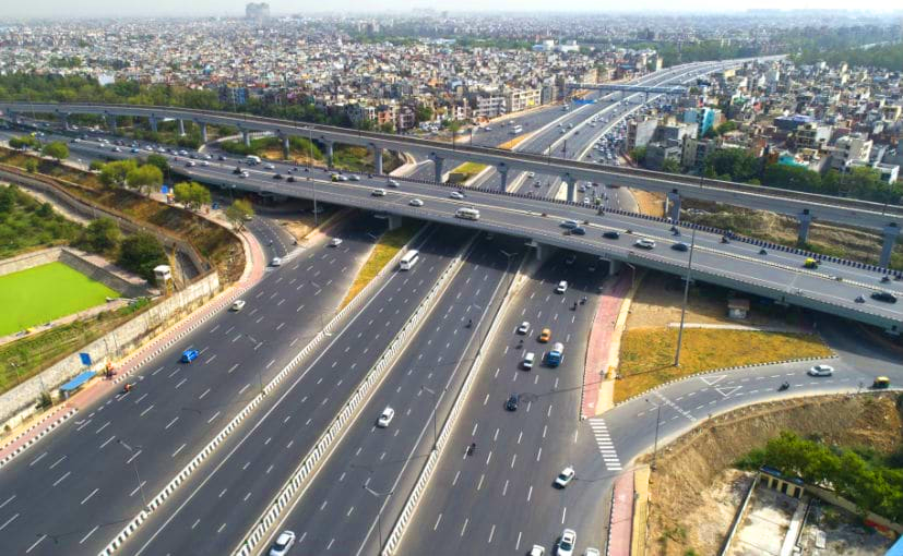
Content improved for clarity and flow |
CleanupBot (talk | contribs) m Robot: Replacing encoded entity with character |
||
| Line 34: | Line 34: | ||
| subdivision_name = {{flag|India}} | | subdivision_name = {{flag|India}} | ||
| subdivision_type1 = [[States and union territories of India|States]] | | subdivision_type1 = [[States and union territories of India|States]] | ||
| subdivision_name1 = {{flagicon image|Flag_of_Haryana.svg}} [[Haryana]] | | subdivision_name1 = {{flagicon image|Flag_of_Haryana.svg}} [[Haryana]]<br />{{flagicon image|Flag_of_Uttar_Pradesh.svg}} [[Uttar Pradesh]]<br />{{flagicon image|Flag_of_Rajasthan.svg}} [[Rajasthan]] | ||
| subdivision_type2 = [[Union territory]] | | subdivision_type2 = [[Union territory]] | ||
| subdivision_name2 = {{flagicon image|Flag of Delhi Capital Territory.svg}} [[Delhi]] | | subdivision_name2 = {{flagicon image|Flag of Delhi Capital Territory.svg}} [[Delhi]] | ||
| established_title = Created | | established_title = Created | ||
| established_date = 1985 | | established_date = 1985<ref name="NCRPBA85"/> | ||
| seat_type = Major cities | | seat_type = Major cities | ||
| seat = [[Delhi]], [[Faridabad]], [[Ghaziabad]], [[Gurugram]], [[Noida]] | | seat = [[Delhi]], [[Faridabad]], [[Ghaziabad]], [[Gurugram]], [[Noida]] | ||
| Line 45: | Line 45: | ||
| unit_pref = Metric | | unit_pref = Metric | ||
| area_total_km2 = 55083 | | area_total_km2 = 55083 | ||
| area_footnotes = | | area_footnotes = <ref name="ncrpb">{{Cite web|title=NCR Constituent Areas|url=http://ncrpb.nic.in/ncrconstituent.html|url-status=live|website=National Capital Region Planning Board |archive-url=https://web.archive.org/web/20230403065316/https://ncrpb.nic.in/ncrconstituent.html |archive-date=Apr 3, 2023 }}</ref> | ||
| population_footnotes = | | population_footnotes = <ref name="profile"/>{{rp|6}} | ||
| population_total = 58157286 | | population_total = 58157286 | ||
| population_as_of = 2011 | | population_as_of = 2011 | ||
| population_density_km2 = auto | | population_density_km2 = auto | ||
| demographics_type2 = GDP | | demographics_type2 = GDP | ||
| demographics2_footnotes = | | demographics2_footnotes = <ref>{{cite web|title=Draft regional plan-NCR|url=https://ncrpb.nic.in/pdf_files/DraftRegionalPlan-2041_English.pdf}}</ref> | ||
| demographics2_title1 = Total | | demographics2_title1 = Total | ||
| demographics2_info1 = US$370 billion | | demographics2_info1 = US$370 billion | ||
| Line 65: | Line 65: | ||
}} | }} | ||
The '''National Capital Region''' ('''NCR'''; {{Transliteration|hi|ISO|Rāṣṭrīya Rājadhānī Kṣetra}}) is a region centred on the city of [[Delhi]], a special [[union territory]] of [[India]] that hosts the country's capital city [[New Delhi]]. It encompasses the entirety of Delhi and a number of adjacent districts from the states of [[Haryana]], [[Uttar Pradesh]], and [[Rajasthan]]. | The '''National Capital Region''' ('''NCR'''; {{Transliteration|hi|ISO|Rāṣṭrīya Rājadhānī Kṣetra}}) is a region centred on the city of [[Delhi]], a special [[union territory]] of [[India]] that hosts the country's capital city [[New Delhi]]. It encompasses the entirety of Delhi and a number of adjacent districts from the states of [[Haryana]], [[Uttar Pradesh]], and [[Rajasthan]].<ref name="ncrpb"/> The NCR and the associated National Capital Region Planning Board (NCRPB) were created in 1985 to plan the development of the region and to evolve "harmonized policies for the control of land-uses and development of infrastructure" in the region.<ref name="1985act"/> Prominent cities of the NCR are Delhi, New Delhi, [[Faridabad]], Gurgaon, [[Noida]], [[Ghaziabad]] and [[Meerut]]. | ||
The NCR is a mixed, rural-urban region, with a population of over 46,069,000 and an [[urbanisation]] of 62.6 percent. | The NCR is a mixed, rural-urban region, with a population of over 46,069,000 and an [[urbanisation]] of 62.6 percent.<ref name="profile">{{cite web|title=Census 2011|url=http://ncrpb.nic.in/pdf_files/Annual%20Report%202014-15.pdf|website=National Capital Region Planning Board|publisher=National Informatics Centre|access-date=26 March 2016|page=3|archive-url=https://web.archive.org/web/20160406160207/http://ncrpb.nic.in/pdf_files/Annual%20Report%202014-15.pdf|archive-date=6 April 2016|url-status=dead}}</ref> There are also areas like the [[Delhi Ridge|Aravalli ridge]], [[forest]]s, [[Wildlife sanctuaries|wildlife]] and [[bird sanctuaries]].<ref name="IndExp-Jan14">{{cite web|title=NCR expands, planning lags|url=http://indianexpress.com/article/business/business-others/ncr-expands-planning-lags/|website=The Indian Express|date=18 January 2014|access-date=19 March 2017|archive-url=https://web.archive.org/web/20170320053829/http://indianexpress.com/article/business/business-others/ncr-expands-planning-lags/|archive-date=20 March 2017|url-status=live}}</ref> The Delhi Extended [[Urban Agglomeration]], the inner part of the NCR, had an estimated GDP of $370 billion (measured in terms of GDP PPP) in 2015–16.<ref>{{cite web|title=With GDP of $370 billion, Delhi-NCR muscles out Mumbai as economic capital of India|url=http://www.financialexpress.com/opinion/with-gdp-of-370-billion-delhi-ncr-muscles-out-mumbai-as-economic-capital-of-india/458742/|website=[[The Financial Express (India)|The Financial Express]]|date=29 November 2016|access-date=14 July 2017|archive-url=https://web.archive.org/web/20170710020202/http://www.financialexpress.com/opinion/with-gdp-of-370-billion-delhi-ncr-muscles-out-mumbai-as-economic-capital-of-india/458742/|archive-date=10 July 2017|url-status=live}}</ref> Despite being a part of the NCR, the [[Government of India|Government of India's]] think tank, [[NITI Aayog]], listed the [[Nuh district]] of Haryana as the most underdeveloped across India's 739 districts.<ref>{{Cite news |date=2018-04-01 |title=Nuh at bottom of Niti Aayog’s 101 most backward districts |url=https://www.thehindu.com/news/cities/Delhi/nuh-at-bottom-of-niti-aayogs-101-most-backward-districts/article61871165.ece |access-date=2023-08-22 |work=The Hindu |language=en-IN |issn=0971-751X}}</ref> | ||
== History == | == History == | ||
The National Capital Region (NCR) and its planning board were created under the National Capital Region Planning Board Act of 1985. | The National Capital Region (NCR) and its planning board were created under the National Capital Region Planning Board Act of 1985.<ref name="NCRPBA85">{{cite web|title=Rationale|url=http://ncrpb.nic.in/rationale.php|website=ncrpb.nic.in|publisher=NCR Planning Board|quote=The National Capital Region (NCR) in [[India]] was constituted under the NCRPB Act, 1985|access-date=5 March 2013|archive-url=https://web.archive.org/web/20121216113422/http://www.ncrpb.nic.in/rationale.php|archive-date=16 December 2012|url-status=dead}}</ref> That 1985 Act defined the NCR as being the whole of Delhi; the Haryana districts of [[Gurgaon district|Gurgaon]] (then including the [[Nuh district]]), [[Faridabad district|Faridabad]] and [[Sonipat district|Sonipat]], [[Rohtak district|Rohtak]] (then including [[Jhajjar]] tehsil) and the [[Rewari]] tehsil then in [[Mahendragarh district]]; and the [[Uttar Pradesh]] districts of [[Bulandshahr district|Bulandshahr]], [[Muzaffarnagar district|Muzaffarnagar]], [[Meerut district|Meerut]] (then including [[Baghpat]] tehsil), and [[Ghaziabad district, India|Ghaziabad]] (then including [[Hapur]] tehsil), and some part of the [[Rajasthan]] district of [[Alwar district|Alwar]].<ref>{{cite web|title=NCR Planning Board Act of 1985|url=http://ncrpb.nic.in/pdf_files/Act%201985.pdf|date=1985}}</ref><ref name="1985act">{{cite web|title=The Gazette of India, National Capital Region Planning Board Act of 1985|url=http://ncrpb.nic.in/pdf_files/ncrpb_act_1985.pdf|publisher=NCR Planning Board|access-date=5 March 2017|date=1985|archive-url=https://web.archive.org/web/20120828095834/http://ncrpb.nic.in/pdf_files/ncrpb_act_1985.pdf|archive-date=28 August 2012|url-status=dead}}</ref> The 1985 boundary of the NCR covered an area of {{convert|34,144|km2}}.<ref name="profile"/>{{rp|3}} | ||
Prior to the creation of the NCR, an area described as the Delhi Metropolitan Area (DMA) was described in the 1962 Master Plan for Delhi. That plan defined the DMA as comprising the National Capital Territory and the ''ring towns'' of [[Ghaziabad]], [[Faridabad]], [[Ballabhgarh]], [[Gurgaon]], [[Bahadurgarh]] and [[Loni, Ghaziabad|Loni]], also certain rural areas, which had a population of the somewhat less than 2.1 million in 1951. | Prior to the creation of the NCR, an area described as the Delhi Metropolitan Area (DMA) was described in the 1962 Master Plan for Delhi. That plan defined the DMA as comprising the National Capital Territory and the ''ring towns'' of [[Ghaziabad]], [[Faridabad]], [[Ballabhgarh]], [[Gurgaon]], [[Bahadurgarh]] and [[Loni, Ghaziabad|Loni]], also certain rural areas, which had a population of the somewhat less than 2.1 million in 1951.<ref>{{cite web|title=Master Plan for Delhi|url=http://rgplan.org/delhi/MASTER-PLAN-FOR-DELHI_1962.pdf|website=rgplan.org|publisher=Delhi Development Authority|access-date=19 March 2017|date=1 September 1962|archive-url=https://web.archive.org/web/20160911084529/http://rgplan.org/delhi/MASTER-PLAN-FOR-DELHI_1962.pdf|archive-date=11 September 2016|url-status=live}}</ref> The following "Master Plan for Delhi", approved in August 1990, added [[Noida]], [[Bahadurgarh]] and the then-proposed township of [[Kundli]] to the DMA, which consequently covered an area of 3,182&nbsp;km<sup>2</sup>.<ref>{{cite web|title=Master Plan for Delhi|url=http://www.rgplan.org/delhi/MASTER-PLAN-FOR-DELHI_2.pdf|publisher=Delhi Development Authority|access-date=19 March 2017|page=8|date=August 1990|archive-url=https://web.archive.org/web/20170828154900/http://www.rgplan.org/delhi/MASTER-PLAN-FOR-DELHI_2.pdf|archive-date=28 August 2017|url-status=live}}</ref> | ||
[[Gautam Budh Nagar district]] was created in 1997 out of the existing NCR districts of Ghaziabad and Bulandshahr. The city of Noida was the location of the new district's headquarters. | [[Gautam Budh Nagar district]] was created in 1997 out of the existing NCR districts of Ghaziabad and Bulandshahr. The city of Noida was the location of the new district's headquarters.<ref>{{cite web |title=Brief Industrial Profile of Gautam Budh Nagar |url=http://dcmsme.gov.in/dips/DIP%20Report%20Gautam%20Budh%20Nagar.pdf |publisher=Government of India Micro, Small and Medium Enterprises |page=1 |date=14 August 2012 |access-date=28 July 2018 |archive-url=https://web.archive.org/web/20181123113125/http://dcmsme.gov.in/dips/DIP%20Report%20Gautam%20Budh%20Nagar.pdf |archive-date=23 November 2018 |url-status=live }}</ref> Also in 1997 [[Baghpat district]] was created from Baghpat tehsil of Meerut district.<ref>{{cite web |title=Census of India 2011 – Uttar Pradesh – District Census Handbook – Baghpat |url=http://www.censusindia.gov.in/2011census/dchb/0908_PART_B_DCHB_BAGHPAT.pdf |date=2011 |page=9 |website=Office of the Registrar General & Census Commissioner, India |access-date=7 July 2016 |archive-url=https://web.archive.org/web/20151114012629/http://www.censusindia.gov.in/2011census/dchb/0908_PART_B_DCHB_BAGHPAT.pdf |archive-date=14 November 2015 |url-status=live }}</ref> | ||
In July 2013, the NCR was expanded to include three more districts, [[Bhiwani district|Bhiwani]], and [[Mahendragarh district|Mahendragarh]] in the state of [[Haryana]], as well as [[Bharatpur district|Bharatpur]] in the state of [[Rajasthan]]. This brought the number of districts in the NCR to 19 (outside Delhi NCT), with the total NCR area increasing 34% to 45,887&nbsp;km | In July 2013, the NCR was expanded to include three more districts, [[Bhiwani district|Bhiwani]], and [[Mahendragarh district|Mahendragarh]] in the state of [[Haryana]], as well as [[Bharatpur district|Bharatpur]] in the state of [[Rajasthan]]. This brought the number of districts in the NCR to 19 (outside Delhi NCT), with the total NCR area increasing 34% to 45,887&nbsp;km<sup>2</sup>.<ref>{{cite web|title=The Organisation and Administration|url=http://moud.gov.in/upload/uploadfiles/files/InductionMaterial_0.pdf|website=Ministry of Urban Development|publisher=Government of India|page=32|quote=Government of India vide Notification dated 1.10.2013 has included Bhiwani and Mahendragarh districts of the State of Haryana and Bharatpur district of the State of Rajasthan|access-date=7 April 2017|archive-url=https://web.archive.org/web/20170408083513/http://moud.gov.in/upload/uploadfiles/files/InductionMaterial_0.pdf|archive-date=8 April 2017|url-status=dead}}</ref><ref>{{cite web|title=3 more districts enter National Capital Region fold – The Times of India|url=http://timesofindia.indiatimes.com/city/delhi/3-more-districts-enter-National-Capital-Region-fold/articleshow/20867549.cms?referral=PM|work=[[The Times of India]]|date=2 July 2013|access-date=4 January 2015|archive-url=https://web.archive.org/web/20161003120603/http://timesofindia.indiatimes.com/city/delhi/3-more-districts-enter-National-Capital-Region-fold/articleshow/20867549.cms?referral=PM|archive-date=3 October 2016|url-status=live}}</ref> Subsequently, [[Charkhi Dadri district]] was separated from Bhiwani district in 2016.<ref>{{cite news|title=Charki Dadri notified as 22nd district of Haryana|url=http://timesofindia.indiatimes.com/city/chandigarh/Charki-Dadri-notified-as-22nd-district-of-Haryana/articleshow/55803185.cms|work=The Times of India|date=5 December 2016|access-date=13 July 2017|archive-url=https://web.archive.org/web/20161206045347/http://timesofindia.indiatimes.com/city/chandigarh/Charki-Dadri-notified-as-22nd-district-of-Haryana/articleshow/55803185.cms|archive-date=6 December 2016|url-status=live}}</ref> | ||
On 9 June 2015, the Government of India approved the inclusion of three more districts in NCR – [[Jind district|Jind, Panipat]], [[Karnal district|Karnal]] in the state of [[Haryana]] and [[Muzaffarnagar district|Muzaffarnagar]] in [[Uttar Pradesh]]. | On 9 June 2015, the Government of India approved the inclusion of three more districts in NCR – [[Jind district|Jind, Panipat]], [[Karnal district|Karnal]] in the state of [[Haryana]] and [[Muzaffarnagar district|Muzaffarnagar]] in [[Uttar Pradesh]].<ref>{{cite news|url=http://economictimes.indiatimes.com/news/politics-and-nation/ncr-gets-bigger-jind-karnal-and-muzaffarnagar-districts-added/articleshow/47600351.cms|title=NCR gets bigger; Jind, Karnal and Muzaffarnagar districts added|work=The Economic Times|access-date=28 July 2015|archive-url=https://web.archive.org/web/20150612094923/http://economictimes.indiatimes.com/news/politics-and-nation/ncr-gets-bigger-jind-karnal-and-muzaffarnagar-districts-added/articleshow/47600351.cms|archive-date=12 June 2015|url-status=live}}</ref><ref>{{cite web|url=https://www.indiatoday.in/india/north/story/ncr-3-new-districts-jind-karnal-and-muzaffarnagar-256451-2015-06-09|title=NCR to now include these 3 new districts|access-date=9 June 2015|archive-url=https://web.archive.org/web/20150609180709/http://indiatoday.intoday.in/story/ncr-3-new-districts-jind-karnal-and-muzaffarnagar/1/443205.html|archive-date=9 June 2015|url-status=live}}</ref><ref>{{cite news|url=http://www.business-standard.com/video-gallery/general/ncr-to-now-include-3-new-districts-part-2-21815/ncr-to-now-include-3-new-districts-part-2-22106.htm|title=NCR to now include 3 new districts – Part – 2|author=Business Standard|newspaper=Business Standard India |date=9 June 2015 |access-date=28 July 2015|archive-url=https://web.archive.org/web/20160305142240/http://www.business-standard.com/video-gallery/general/ncr-to-now-include-3-new-districts-part-2-21815/ncr-to-now-include-3-new-districts-part-2-22106.htm|archive-date=5 March 2016|url-status=live}}</ref><ref>{{Cite web|title = Jind and Karnal now at NCR – हरियाणा के 2 और जिले NCR में Amar Ujala|url = http://www.amarujala.com/news/delhi-ncr/delhi-news-ncr/jind-and-karnal-now-at-ncr/|website = delhincr.amarujala.com|archive-url = https://web.archive.org/web/20140121085912/http://www.amarujala.com/news/delhi-ncr/delhi-news-ncr/jind-and-karnal-now-at-ncr/|archive-date = 21 January 2014|url-status = live}}</ref> covering a total area of 50,566&nbsp;km<sup>2</sup>.<ref name="tcpharyana">{{cite web|title=Sub-Regional Plan for Haryana Sub-Region of NCR-2021|url=https://www.tcpharyana.gov.in/ncrpb/FINAL%20SRP%20FOR%20WEB-HOSTING/01_Introduction.pdf|website=Department of Town & Country Planning|publisher=Government of Haryana|page=2|date=10 June 2016|access-date=7 April 2017|archive-url=https://web.archive.org/web/20160212145300/http://www.tcpharyana.gov.in/ncrpb/FINAL%20SRP%20FOR%20WEB-HOSTING/01_Introduction.pdf|archive-date=12 February 2016|url-status=live}}</ref> [[Shamli district]] of U.P. was added to the NCR in December 2017.<ref>{{cite news |title=NCR-shamli-inclusion |url=https://www.thehindu.com/todays-paper/tp-national/tp-newdelhi/ncr-shamli-inclusion/article21263265.ece |work=The Hindu |date=5 December 2017 |language=en-IN}}</ref> As of 2021, there are a total of 24 districts in the NCR, excluding the 11 [[districts of Delhi]]. | ||
=== Proposed extensions === | === Proposed extensions === | ||
On 9 January 2018, the [[government of Uttar Pradesh]] formally proposed the extension of the NCR to cover the districts [[Aligarh district|Aligarh]], [[Bijnor district|Bijnor]], [[Hathras district|Hathras]] and [[Mathura district|Mathura]]. | On 9 January 2018, the [[government of Uttar Pradesh]] formally proposed the extension of the NCR to cover the districts [[Aligarh district|Aligarh]], [[Bijnor district|Bijnor]], [[Hathras district|Hathras]] and [[Mathura district|Mathura]].<ref>{{cite news|last1=Dabas|first1=Harveer|title=UP govt sends proposal to include Bijnor, Mathura, Aligarh & Hathras in NCR|url=https://timesofindia.indiatimes.com/city/meerut/up-govt-sends-proposal-to-include-bijnor-mathura-aligarh-hathras-in-ncr/articleshow/62434756.cms|work=The Times of India|date=9 January 2018|access-date=9 January 2018|archive-url=https://web.archive.org/web/20180110183419/https://timesofindia.indiatimes.com/city/meerut/up-govt-sends-proposal-to-include-bijnor-mathura-aligarh-hathras-in-ncr/articleshow/62434756.cms|archive-date=10 January 2018|url-status=live}}</ref> | ||
=== Proposed reductions === | === Proposed reductions === | ||
Under the "Draft Regional Plan 2041", it has been proposed to limit the NCR region to 100-km radius from Rajghat in [[Delhi]] for more focused and sustainable development of the region. | Under the "Draft Regional Plan 2041", it has been proposed to limit the NCR region to 100-km radius from Rajghat in [[Delhi]] for more focused and sustainable development of the region.<ref>{{Cite web |date=17 December 2021 |title='Draft Regional Plan 2041' To Limit NCR Region Around Delhi. Details Here |url=https://www.ndtv.com/india-news/draft-regional-plan-2041-to-limit-ncr-region-around-delhi-details-here-2656719 |access-date=24 June 2022 |website=NDTV.com}}</ref><ref>{{Cite web |date=2021-10-14 |title=Proposal to shrink National Capital Region |url=https://www.hindustantimes.com/cities/delhi-news/proposal-to-shrink-national-capital-region-101634150921548.html |access-date=2022-06-24 |website=Hindustan Times |language=en}}</ref> Government of Haryana has requested NCRPB for at least one-third reduction of its share in the NCR region.<ref>{{Cite web |date=2022-02-26 |title=Haryana seeks one-third reduction of area under National Capital Region |url=https://indianexpress.com/article/cities/chandigarh/haryana-seeks-one-third-reduction-of-area-under-ncr-7790863/ |access-date=2022-06-24 |website=The Indian Express |language=en}}</ref> | ||
== Component districts == | == Component districts == | ||
A total of 24 districts in three neighbouring states of [[Haryana]], [[Uttar Pradesh]] and [[Rajasthan]] along with whole of the National Capital Territory of [[Delhi]] constitute the National Capital Region (NCR) of India. | A total of 24 districts in three neighbouring states of [[Haryana]], [[Uttar Pradesh]] and [[Rajasthan]] along with whole of the National Capital Territory of [[Delhi]] constitute the National Capital Region (NCR) of India.<ref name="NCRPB Rationale">[http://ncrpb.nic.in/rationale.php National Capital Region Planning Board] {{Webarchive|url=https://web.archive.org/web/20121216113422/http://www.ncrpb.nic.in/rationale.php |date=16 December 2012 }}. Ncrpb.nic.in. Retrieved on 16 July 2013.</ref> | ||
The areas and populations (per 2011 census, prior to the addition of [[Muzaffarnagar]], Jind, Karnal and [[Shamli]]) of these component districts are set out below: | The areas and populations (per 2011 census, prior to the addition of [[Muzaffarnagar]], Jind, Karnal and [[Shamli]]) of these component districts are set out below:<ref name="ncrpb"/><ref name="profile"/>{{rp|3,6}} | ||
{| class="sortable wikitable" | {| class="sortable wikitable" | ||
|- | |- | ||
! State/UT || Districts || Area | ! State/UT || Districts || Area<br>(km<sup>2</sup>) || Population<br>(in thousands) || GDP {{Nobold|(Nominal)}} | ||
|- | |- | ||
| rowspan=11 style="text-align:center;"|[[Delhi]] | | rowspan=11 style="text-align:center;"|[[Delhi]] | ||
| Line 98: | Line 98: | ||
| rowspan=11 style="text-align:right;"|1,483 | | rowspan=11 style="text-align:right;"|1,483 | ||
| rowspan=11 style="text-align:right;"|16,788 | | rowspan=11 style="text-align:right;"|16,788 | ||
| rowspan=11 style="text-align:right;"|₹{{FXConvert|IND|11080|b|lk=on}} | | rowspan=11 style="text-align:right;"|₹{{FXConvert|IND|11080|b|lk=on}}<ref name="NSDP">{{cite web|url=https://delhiplanning.delhi.gov.in/sites/default/files/Planning/economic_survey_of_delhi_2023-24_english.pdf|title=ECONOMIC SURVEY OF DELHI 2023 – 24|website=delhiplanning.delhi.gov.in|access-date=15 August 2024|archive-date=30 September 2024|archive-url=https://web.archive.org/web/20240930092641/https://delhiplanning.delhi.gov.in/sites/default/files/Planning/economic_survey_of_delhi_2023-24_english.pdf|url-status=dead}}</ref> | ||
|- | |- | ||
| [[East Delhi]] | | [[East Delhi]] | ||
| Line 124: | Line 124: | ||
| rowspan=14 style="text-align:right;"|25,327 | | rowspan=14 style="text-align:right;"|25,327 | ||
| rowspan=14 style="text-align:right;"|16,427 | | rowspan=14 style="text-align:right;"|16,427 | ||
| rowspan=14 style="text-align:right;"|₹{{FXConvert|IND|14170|b|lk=on}} | | rowspan=14 style="text-align:right;"|₹{{FXConvert|IND|14170|b|lk=on}}<ref name="Survey1">{{cite web|url=http://web1.hry.nic.in/budget/esurvey.pdf|title=Economic Survey of Haryana 2020-21|work=[[Government of Haryana]]|pages=2–3|date=1 February 2022|access-date=1 February 2022|archive-date=19 January 2022|archive-url=https://web.archive.org/web/20220119164659/http://web1.hry.nic.in/budget/Esurvey.pdf|url-status=dead}}</ref> | ||
|- | |- | ||
| [[Charkhi Dadri district|Charkhi Dadri]] | | [[Charkhi Dadri district|Charkhi Dadri]] | ||
| Line 156: | Line 156: | ||
| rowspan=2 style="text-align:right;"|13,447 | | rowspan=2 style="text-align:right;"|13,447 | ||
| rowspan=2 style="text-align:right;"|4,633 | | rowspan=2 style="text-align:right;"|4,633 | ||
| rowspan=2 style="text-align:right;"|₹{{FXConvert|IND|940|b|lk=on}} | | rowspan=2 style="text-align:right;"|₹{{FXConvert|IND|940|b|lk=on}}<ref>{{cite web|title=indiastatdistricts|url=https://www.indiastatdistricts.com/|website=www.indiastatdistricts.com}}</ref> | ||
|- | |- | ||
| [[Bharatpur district|Bharatpur]] | | [[Bharatpur district|Bharatpur]] | ||
| Line 164: | Line 164: | ||
| rowspan=8 style="text-align:right;"|14,826 | | rowspan=8 style="text-align:right;"|14,826 | ||
| rowspan=8 style="text-align:right;"|17,105 | | rowspan=8 style="text-align:right;"|17,105 | ||
| rowspan=8 style="text-align:right;"|₹{{FXConvert|IND|3350|b|lk=on}} | | rowspan=8 style="text-align:right;"|₹{{FXConvert|IND|3350|b|lk=on}}<ref>{{cite web|title=indiastatdistricts|url=https://www.indiastatdistricts.com/|website=www.indiastatdistricts.com}}</ref> | ||
|- | |- | ||
| [[Bulandshahr district|Bulandshahr]] | | [[Bulandshahr district|Bulandshahr]] | ||
| Line 190: | Line 190: | ||
{{Further | Aravalli Range#Wall | l1= The Great Green Wall of Aravalli | Forests Department, Haryana#Leopards | l2= Leopards of Haryana}} | {{Further | Aravalli Range#Wall | l1= The Great Green Wall of Aravalli | Forests Department, Haryana#Leopards | l2= Leopards of Haryana}} | ||
The planning body for the region is the '''National Capital Region Planning Board''' (NCRPB). It has issued two regional plans, the "Regional Plan 2001, National Capital Region" approved in 1988, | The planning body for the region is the '''National Capital Region Planning Board''' (NCRPB). It has issued two regional plans, the "Regional Plan 2001, National Capital Region" approved in 1988,<ref name="reg plan 2001"/> and the "Regional Plan 2021, National Capital Region" approved in 2005.<ref>{{cite web|title=Regional Plan 2021, Background|url=http://ncrpb.nic.in/pre_regionalplan2021.php|website=ncrpb.nic.in|publisher=NCR Planning Board|access-date=7 March 2017|archive-url=https://web.archive.org/web/20170518023907/http://ncrpb.nic.in/pre_regionalplan2021.php|archive-date=18 May 2017|url-status=live}}</ref> Topics covered by the 2001 plan included transport, telecommunications, power and water supply, waste and sewerage, education, health, the environment, housing and the "counter magnet" areas. The 2021 plan extended these with the additional topics of social infrastructure, heritage, tourism, rural development, and disaster management. | ||
The 51% of pollution in NCR is caused by the industrial pollution, 27% by vehicles and 8% by [[Stubble burning#Stubble burning in India|crop burning]], consequently there are plans to create a 1,600&nbsp;km long and 5&nbsp;km wide [[Aravalli Range#Wall|The Great Green Wall of Aravalli]] green ecological corridor along Aravalli range from Gujarat to Delhi to be connected to [[Sivalik Hills|Sivalik]] hill range with the planting of 1.35 billion (135 crore) new native trees over 10 years. | The 51% of pollution in NCR is caused by the industrial pollution, 27% by vehicles and 8% by [[Stubble burning#Stubble burning in India|crop burning]], consequently there are plans to create a 1,600&nbsp;km long and 5&nbsp;km wide [[Aravalli Range#Wall|The Great Green Wall of Aravalli]] green ecological corridor along Aravalli range from Gujarat to Delhi to be connected to [[Sivalik Hills|Sivalik]] hill range with the planting of 1.35 billion (135 crore) new native trees over 10 years.<ref name=wall1>[https://indianexpress.com/article/cities/ahmedabad/want-govt-to-build-1600-km-green-wall-along-aravalli-says-activist-vijaypal-baghel-6182069/ Want govt to build 1600 km green wall along Aravalli] {{Webarchive|url=https://web.archive.org/web/20191224165431/https://indianexpress.com/article/cities/ahmedabad/want-govt-to-build-1600-km-green-wall-along-aravalli-says-activist-vijaypal-baghel-6182069/ |date=24 December 2019 }}, Indian Express, 24 December 2019.</ref> About 46% of the National Capital Region, home to 40 to 50 million people, is not connected to sewage networks. Sewage from these areas flows into stormwater drains that empty directly into the [[Yamuna]].<ref>{{cite web|url=http://timesofindia.indiatimes.com/city/delhi/No-sewerage-in-46-of-NCR/articleshow/34602984.cms|title=No sewerage in 46% of NCR|work=The Times of India|access-date=28 July 2015|archive-url=https://web.archive.org/web/20140504091339/http://timesofindia.indiatimes.com/city/delhi/No-sewerage-in-46-of-NCR/articleshow/34602984.cms|archive-date=4 May 2014|url-status=live}}</ref> | ||
A Sports University is proposed to be established in Meerut district of UP Sub-Region. | A Sports University is proposed to be established in Meerut district of UP Sub-Region. | ||
== Judicial System == | == Judicial System == | ||
Delhi NCR has only one high court, which is in Delhi. While it is highly suggested in Regional Plan 2041, Delhi NCR that high court bench must be set up in western Uttar Pradesh, large part of which falls in Delhi NCR. There has been long standing demand for high court bench in [[Meerut]]. | Delhi NCR has only one high court, which is in Delhi. While it is highly suggested in Regional Plan 2041, Delhi NCR that high court bench must be set up in western Uttar Pradesh, large part of which falls in Delhi NCR. There has been long standing demand for high court bench in [[Meerut]].<ref>{{Cite news |date=2021-09-26 |title=Demand for high court Bench in Meerut returns |work=The Times of India |url=https://timesofindia.indiatimes.com/city/meerut/demand-for-hc-bench-in-meerut-returns-as-up-poll-date-gets-closer/articleshow/86515586.cms |access-date=2023-10-03 |issn=0971-8257}}</ref> | ||
Regional Plan 2041, Delhi NCR suggests that industrial growth of western Uttar Pradesh's part of Delhi NCR is being hampered due to unavailability of judicial system. Almost 54% of all cases reaching the High Court originate from the 22 districts of Western UP. | Regional Plan 2041, Delhi NCR suggests that industrial growth of western Uttar Pradesh's part of Delhi NCR is being hampered due to unavailability of judicial system. Almost 54% of all cases reaching the High Court originate from the 22 districts of Western UP. | ||
| Line 209: | Line 209: | ||
[[File:Namo Bharat Train closeup.jpg|thumb|[[Delhi–Meerut Regional Rapid Transit System|Delhi Meerut RRTS]] Trainset]] | [[File:Namo Bharat Train closeup.jpg|thumb|[[Delhi–Meerut Regional Rapid Transit System|Delhi Meerut RRTS]] Trainset]] | ||
For greater ease of transportation within the National Capital Region, India's first Regional Rapid Transit System (RRTS), called [[Namo Bharat Rapid Rail]] and Vande Metro, | For greater ease of transportation within the National Capital Region, India's first Regional Rapid Transit System (RRTS), called [[Namo Bharat Rapid Rail]] and Vande Metro,<ref>{{Cite web |date=2024-09-16 |title=India's first Vande Metro renamed Namo Bharat Rapid Rail: All you need to know |url=https://indianexpress.com/article/cities/ahmedabad/pm-modi-first-vande-metro-all-you-need-to-know-9570064/ |access-date=2024-09-16 |website=The Indian Express |language=en}}</ref><ref>{{cite news|url=https://www.business-standard.com/industry/news/rcf-to-roll-out-first-prototype-of-vande-metro-coach-by-april-s-srinivas-124021100139_1.html|title=RCF to roll out first prototype of Vande Metro coach by April: S Srinivas|date=11 February 2024|newspaper=[[Business Standard]]|access-date=11 February 2024}}</ref> with 8 [[Higher-speed rail|semi-high speed rail]] corridors is being developed in phases in Delhi NCR: an implementation of plans made by [[Planning Commission (India)|India's Planning Commission]].<ref name=rrtsnewp1>[https://www.news9live.com/city/delhi/delhi-ncr-rrts-network-all-about-8-planned-namo-bharat-rapid-rail-corridors-2789531 Delhi NCR RRTS network: All about 8 planned Namo Bharat Rapid Rail corridors], News9, 4 Jan 2025.</ref><ref name=rrtsnewp2>{{Cite web |title=Project Overview – NCRTC |url=https://ncrtc.in/overview-project/ |access-date=2023-10-03 |language=en-US}}</ref> The RapidX trains will have a maximum trial speed of 180 km/h (110 mph) and a maximum operational speed of 160 km/h (99 mph). | ||
* Phase-1: First phase has the following 3 priority corridors: | * Phase-1: First phase has the following 3 priority corridors: | ||
** [[Delhi–Meerut Regional Rapid Transit System|Delhi-Meerut RRTS]]: It is an 82.15 km (51.05 mi) long line, India's first RRTS, which will be fully completed by 2025. | ** [[Delhi–Meerut Regional Rapid Transit System|Delhi-Meerut RRTS]]: It is an 82.15 km (51.05 mi) long line, India's first RRTS, which will be fully completed by 2025.<ref name=rrtsnewp2/> | ||
** [[Delhi–Alwar Regional Rapid Transit System|Delhi-Gurugram-SNB-Alwar]] (Pre-construction), expected to be completed by 2028. | ** [[Delhi–Alwar Regional Rapid Transit System|Delhi-Gurugram-SNB-Alwar]] (Pre-construction), expected to be completed by 2028.<ref name=rrtsnewp2/> DPR has been completed and under review by the central government.<ref name=upsept1>[https://indianexpress.com/article/cities/delhi/dmrc-to-soon-handover-rapid-metro-ops-in-gurgaon-amid-surge-in-footfall-revenue-10252308/ DMRC to soon handover Rapid Metro ops in Gurgaon amid surge in footfall, revenue], Indian Express, 16 Sept 2025.</ref> | ||
** [[Delhi–Sonipat–Panipat Regional Rapid Transit System|Delhi-Panipat-Karnal]]: expanded to total 136.30 km length from Delhi to Karnal (from original 103 km to Panipat) with 21 stations at a cost of Rs 33,051.15 crore, DPR is complete and under review by the central government, | ** [[Delhi–Sonipat–Panipat Regional Rapid Transit System|Delhi-Panipat-Karnal]]: expanded to total 136.30 km length from Delhi to Karnal (from original 103 km to Panipat) with 21 stations at a cost of Rs 33,051.15 crore, DPR is complete and under review by the central government,<ref name=upsept1/> expected to be completed after 2028.<ref name=rrtsnewp2/> | ||
* Phase-2: remaining 5 proposed corridors of under original 8 Namo Bharat RRTS corridors. | * Phase-2: remaining 5 proposed corridors of under original 8 Namo Bharat RRTS corridors. | ||
** Delhi–Faridabad–Palwal RRTS | ** Delhi–Faridabad–Palwal RRTS<ref name=rrtsnewp2/> | ||
** Ghaziabad–Khurja RRTS | ** Ghaziabad–Khurja RRTS<ref name=rrtsnewp2/> | ||
** Delhi–Bahadurgarh–Rohtak RRTS: | ** Delhi–Bahadurgarh–Rohtak RRTS:<ref name=rrtsnewp2/> Route is from [[Munirka]] (Delhi) to [[Indira Gandhi International Airport|IGI Delhi Airport T1, T2-T3]], [[Yashobhoomi]], [[Najafgarh]], [[Bahadurgarh]], and [[Rohtak]]. DPR preparation has commenced.<ref name=upsept1/> | ||
** Ghaziabad-Hapur RRTS | ** Ghaziabad-Hapur RRTS<ref name=rrtsnewp2/> | ||
** Delhi-Shahadra-Baraut RRTS | ** Delhi-Shahadra-Baraut RRTS<ref name=rrtsnewp2/> | ||
* Phase-3: Other proposed Namo Bharat RRTS corridors. | * Phase-3: Other proposed Namo Bharat RRTS corridors. | ||
** Gurugram–Faridabad–Noida/Greater Noida Namo Bharat RRTS: DPR preparation has commenced. | ** Gurugram–Faridabad–Noida/Greater Noida Namo Bharat RRTS: DPR preparation has commenced.<ref name=upsept1/> | ||
=== Expressways === | === Expressways === | ||
| Line 245: | Line 245: | ||
=== Dedicated Freight Corridor === | === Dedicated Freight Corridor === | ||
For regional logistic transportation both [[Eastern Dedicated Freight Corridor]] and [[Western Dedicated Freight Corridor]] will pass through Delhi NCR. Sites like Meerut and Dadri are planned to be proposed logistic hub. | For regional logistic transportation both [[Eastern Dedicated Freight Corridor]] and [[Western Dedicated Freight Corridor]] will pass through Delhi NCR. Sites like Meerut and Dadri are planned to be proposed logistic hub.<ref>{{Cite web |title=Invest in UP |url=https://invest.up.gov.in/wp-content/themes/investup/pdf/Warehousing-Logistics-brochure.pdf }}</ref> | ||
Ashok Agarwal, national president, Indian Industries Association (IIA), said “We have also received queries related to the allotment of land along the Ganga Expressway from investors. Most of the queries are for land in [[Meerut]], [[Budaun]] and its adjoining areas”. | Ashok Agarwal, national president, Indian Industries Association (IIA), said “We have also received queries related to the allotment of land along the Ganga Expressway from investors. Most of the queries are for land in [[Meerut]], [[Budaun]] and its adjoining areas”.<ref>{{Cite web |date=2023-05-07 |title=Industrial clusters to come up along Ganga Expressway |url=https://www.hindustantimes.com/cities/lucknow-news/ganga-expressway-to-boost-industrial-clusters-across-12-up-districts-investors-eyeing-meerut-and-budaun-areas-101683470276029.html |access-date=2023-10-03 |website=Hindustan Times |language=en}}</ref> | ||
* Meerut along Delhi Meerut Expressway | * Meerut along Delhi Meerut Expressway | ||
| Line 257: | Line 257: | ||
* '''ORC - I:''' Haryana developing ORC by 2025 connecting Palwal-Sonipat. Uttar Pradesh is also planning to develop ORC connecting Palwal - Khurja - Meerut - Bagapat - Sonipat, to complete the Orbital Circle 1. This is expected to be made fully operational by 2028. | * '''ORC - I:''' Haryana developing ORC by 2025 connecting Palwal-Sonipat. Uttar Pradesh is also planning to develop ORC connecting Palwal - Khurja - Meerut - Bagapat - Sonipat, to complete the Orbital Circle 1. This is expected to be made fully operational by 2028. | ||
* '''ORC - II:''' As “Regional Orbital Rail Corridor (RORC)” connecting Panipat- Shamli- Meerut- Jewar- Nuh- Bhiwadi- Rewari- Jhajjar- Rohtak- Panipat (along CREII) to enable fast regional movement of passenger and goods avoiding CNCR area. | * '''ORC - II:''' As “Regional Orbital Rail Corridor (RORC)” connecting Panipat- Shamli- Meerut- Jewar- Nuh- Bhiwadi- Rewari- Jhajjar- Rohtak- Panipat (along CREII) to enable fast regional movement of passenger and goods avoiding CNCR area. | ||
* '''ORC - III:''' As “Outer Orbital Rail Corridor (OORC)” along CRE-III, is planned by 2041. | * '''ORC - III:''' As “Outer Orbital Rail Corridor (OORC)” along CRE-III, is planned by 2041.<ref name=":0">{{Cite web |title=Delhi NCR Masterplan 2041 |url=https://ncrpb.nic.in/pdf_files/DraftRegionalPlan-2041_English.pdf }}</ref> | ||
=== Railways === | === Railways === | ||
| Line 263: | Line 263: | ||
=== Airports === | === Airports === | ||
Currently there is only one international airport, which is [[Indira Gandhi International Airport|Indira Gandhi Internal Airport]] Delhi. Another airport, [[Noida International Airport|Jewar Airport Noida]] which could become one of Asia's largest airports once full operational is expected to be completed in 2025. Another airport in [[Dr. Bhimrao Ambedkar Airstrip|Dr. Bhimrao Ambedkar Meerut Airport]] is proposed in Regional Plan 2041, Delhi NCR. | Currently there is only one international airport, which is [[Indira Gandhi International Airport|Indira Gandhi Internal Airport]] Delhi. Another airport, [[Noida International Airport|Jewar Airport Noida]] which could become one of Asia's largest airports once full operational is expected to be completed in 2025. Another airport in [[Dr. Bhimrao Ambedkar Airstrip|Dr. Bhimrao Ambedkar Meerut Airport]] is proposed in Regional Plan 2041, Delhi NCR.<ref name=":0" /> | ||
=== Metro === | === Metro === | ||
The city has several metro transit system where the largest network being [[Delhi Metro]] which serves Delhi and other regions of NCR including Faridabad, Noida, Gurgaon and Ghaziabad. [[Noida Metro]] and [[Meerut Metro]] that are separately managed by [[Uttar Pradesh Metro Rail Corporation]] are the other transit metro systems currently in operation in the city. While [[Rapid Metro Gurgaon|Gurgaon Metro]] set to be operated by Haryana Mass Rapid Transport Corporation Limited is under construction. | The city has several metro transit system where the largest network being [[Delhi Metro]] which serves Delhi and other regions of NCR including Faridabad, Noida, Gurgaon and Ghaziabad. [[Noida Metro]] and [[Meerut Metro]] that are separately managed by [[Uttar Pradesh Metro Rail Corporation]] are the other transit metro systems currently in operation in the city. While [[Rapid Metro Gurgaon|Gurgaon Metro]] set to be operated by Haryana Mass Rapid Transport Corporation Limited is under construction.<ref>{{Cite web |date=2024-02-16 |title=PM Modi Inaugurates AIIMS In Haryana's Rewari, Gurugram Metro Rail Project; Check Full Details Here |url=https://www.thedailyjagran.com/india/pm-modi-inaugurates-aiims-in-haryana-rewari-gurugram-metro-rail-project-check-full-details-here-10134001 |access-date=2024-02-17 |website=English Jagran |language=en}}</ref> | ||
==Central National Capital Region== | ==Central National Capital Region== | ||
The 2001 Regional Plan defined the "Delhi Metropolitan Area" (DMA) as comprising the controlled areas of contiguous towns of [[Ghaziabad]]–[[Loni, Ghaziabad|Loni]] and [[Noida]] in [[Uttar Pradesh]]; [[Faridabad]]–[[Ballabhgarh]], [[Gurgaon]], [[Bahadurgarh]], [[Kundli, Haryana|Kundli]] and extension of [[Delhi Ridge]] in [[Haryana]]. The total area of DMA was {{cvt|1696|km2}}, excluding the area of [[Delhi]]. | The 2001 Regional Plan defined the "Delhi Metropolitan Area" (DMA) as comprising the controlled areas of contiguous towns of [[Ghaziabad]]–[[Loni, Ghaziabad|Loni]] and [[Noida]] in [[Uttar Pradesh]]; [[Faridabad]]–[[Ballabhgarh]], [[Gurgaon]], [[Bahadurgarh]], [[Kundli, Haryana|Kundli]] and extension of [[Delhi Ridge]] in [[Haryana]]. The total area of DMA was {{cvt|1696|km2}}, excluding the area of [[Delhi]].<ref>{{Cite web |title=Regional Plan 2001 |url=https://ncrpb.nic.in/pdf_files/RPlan_2001.PDF |website=ncrpb.nic.in}}</ref><ref name="DMA towns">{{cite web |date=September 2007 |title=Evaluation Study of DMA Towns in National Capital Region |url=http://tcpomud.gov.in/divisions/mutp/dma/final_dma_report.pdf |archive-url=https://web.archive.org/web/20170320052724/http://tcpomud.gov.in/divisions/mutp/dma/final_dma_report.pdf |archive-date=20 March 2017 |access-date=19 March 2017 |website=Town and Country Planning Organisation |publisher=[[Ministry of Housing and Urban Affairs|Ministry of Urban Development]]}}</ref> | ||
Under the 2021 Regional plan, the Delhi Metropolitan Area was redesignated as "Central National Capital Region" (CNCR) wherein new areas were added. The CNCR comprises controlled areas of contiguous towns of [[Ghaziabad]]–[[Loni, Ghaziabad|Loni]] and [[Noida]] in Uttar Pradesh; [[Gurgaon]]–[[Manesar]], [[Faridabad]]–[[Ballabhgarh]], [[Bahadurgarh]], and [[Sonipat]]–[[Kundli, Haryana|Kundli]] in Haryana. The total area of CNCR (excluding NCT of Delhi) is approximately {{cvt|2000|km2}}. | Under the 2021 Regional plan, the Delhi Metropolitan Area was redesignated as "Central National Capital Region" (CNCR) wherein new areas were added. The CNCR comprises controlled areas of contiguous towns of [[Ghaziabad]]–[[Loni, Ghaziabad|Loni]] and [[Noida]] in Uttar Pradesh; [[Gurgaon]]–[[Manesar]], [[Faridabad]]–[[Ballabhgarh]], [[Bahadurgarh]], and [[Sonipat]]–[[Kundli, Haryana|Kundli]] in Haryana. The total area of CNCR (excluding NCT of Delhi) is approximately {{cvt|2000|km2}}.<ref>{{Cite web |title=Regional Plan 2021 |url=https://ncrpb.nic.in/regionalplanchapters.html |website=ncrpb.nic.in}}</ref><ref name="DMA towns"/><ref>{{Cite web |title=Study on counter magnet areas to Delhi & NCR |url=http://ncrpb.nic.in/pdf_files/04_Chapter1_cma.pdf |website=ncrpb.nic.in}}</ref> | ||
The 2021 plan estimated the 2001 population of the CNCR outside of Delhi to be over 2.8 million, while Delhi's population was 13.8 million, yielding a total CNCR population of 16.6 million. | The 2021 plan estimated the 2001 population of the CNCR outside of Delhi to be over 2.8 million, while Delhi's population was 13.8 million, yielding a total CNCR population of 16.6 million.<ref>{{cite web|title=Regional Plan 2021 – Chapter 4, Demographic Profile and Settlement Pattern|url=http://ncrpb.nic.in/pdf_files/Regional%20Plan%202021%20chapter/08_CH04%20demographic%20profile%20&%20settlement%20pattern.pdf|publisher=NCR Planning Board|access-date=19 March 2017|page=16|archive-url=https://web.archive.org/web/20170320055054/http://ncrpb.nic.in/pdf_files/Regional%20Plan%202021%20chapter/08_CH04%20demographic%20profile%20%26%20settlement%20pattern.pdf|archive-date=20 March 2017|url-status=live}}</ref> {{as of|2016}} the most recent population estimates have spanned 25.7 to 26.5 million people.<ref name="Demographia">{{cite book|author1=Demographia|title=Demographia World Urban Areas|date=April 2016|edition=12th|url=http://www.demographia.com/db-worldua.pdf|access-date=17 November 2016|archive-url=https://web.archive.org/web/20180503021711/http://www.demographia.com/db-worldua.pdf|archive-date=3 May 2018|url-status=dead}} (excludes Kondli)</ref><ref name="UNcities2016">{{cite web|title=The World's Cities in 2016|url=https://www.un.org/en/development/desa/population/publications/pdf/urbanization/the_worlds_cities_in_2016_data_booklet.pdf|publisher=[[United Nations]]|access-date=4 March 2017|page=4|date=October 2016|archive-url=https://web.archive.org/web/20170112211410/http://www.un.org/en/development/desa/population/publications/pdf/urbanization/the_worlds_cities_in_2016_data_booklet.pdf|archive-date=12 January 2017|url-status=live}}</ref> | ||
== Challenges to NCR == | == Challenges to NCR == | ||
Delhi NCR faces its own set of challenges. | Delhi NCR faces its own set of challenges. | ||
# '''Pollution''' - Due to high industrial growth, pollution from vehicles and stubble burning in Haryana & | # '''Pollution''' - Due to high industrial growth, pollution from vehicles and stubble burning in Haryana & Punjab. Delhi NCR has the worst Air Quality index in the world. | ||
# '''Judicial''' - The western [[Uttar Pradesh]] part of NCR contributes more than 50% of revenue to Uttar Pradesh Government. It has lost and risks losing a lot of corporate investments due to the unavailability of the Judicial System in West Uttar Pradesh. High courts of 6 other Indian states are closer to western Uttar Pradesh than the High court of the state of Uttar Pradesh &mdash; [[Allahabad High Court|Allahabad High court]]. NCR planning board has suggested setting up a high court bench in [[Meerut]] to prevent loss of possible investments. | # '''Judicial''' - The western [[Uttar Pradesh]] part of NCR contributes more than 50% of revenue to Uttar Pradesh Government. It has lost and risks losing a lot of corporate investments due to the unavailability of the Judicial System in West Uttar Pradesh. High courts of 6 other Indian states are closer to western Uttar Pradesh than the High court of the state of Uttar Pradesh &mdash; [[Allahabad High Court|Allahabad High court]]. NCR planning board has suggested setting up a high court bench in [[Meerut]] to prevent loss of possible investments. | ||
# '''Air Connectivity''' - Delhi NCR has only 1 international airport, which is [[Indira Gandhi International Airport|Indira Gandhi Airport]] in Delhi. The upcoming airport in [[Jewar]], Noida is under construction. | # '''Air Connectivity''' - Delhi NCR has only 1 international airport, which is [[Indira Gandhi International Airport|Indira Gandhi Airport]] in Delhi. The upcoming airport in [[Jewar]], Noida is under construction. | ||
==Counter magnets== | ==Counter magnets== | ||
The 1985 Act (§2.c and §8.f) gives the NCRPB the ability to select districts outside of the NCR to act as ''counter magnets'', with a view to developing them further. | The 1985 Act (§2.c and §8.f) gives the NCRPB the ability to select districts outside of the NCR to act as ''counter magnets'', with a view to developing them further.<ref name="1985act"/>{{rp|2,10}} | ||
''Counter-magnet'' cities are identified as those that can be developed as alternative centres of growth and attract migrants to them rather than Delhi. | ''Counter-magnet'' cities are identified as those that can be developed as alternative centres of growth and attract migrants to them rather than Delhi.<ref name="reg plan 2001">{{cite web|title=Regional Plan 2001, National Capital Region|url=http://ncrpb.nic.in/pdf_files/RP-2001.PDF|publisher=NCR Planning Board|date=3 November 1988|quote=the future interceptors of migratory flow|access-date=7 March 2017|archive-url=https://web.archive.org/web/20170308050801/http://ncrpb.nic.in/pdf_files/RP-2001.PDF|archive-date=8 March 2017|url-status=live}}</ref>{{rp|121}} The criteria for selecting counter magnet towns are: that they should have their own established roots and potential of growth,<ref name="reg plan 2001"/>{{rp|121}} and should not be centres of either religious, strategic or environmental importance.{{citation needed|date=March 2017}} The ''counter magnet'' cities should be given priority when allocating funding for development of land, housing and infrastructure.<ref name="reg plan 2001"/>{{rp|126}} | ||
Following are the nine Counter-Magnet Areas to NCR spread across six states: | Following are the nine Counter-Magnet Areas to NCR spread across six states:<ref name="ncrpb constituents">{{Cite web|title = NCR Constituent Areas|url = http://ncrpb.nic.in/ncrconstituent.php|website = National Capital Region Planning Board|archive-url=https://web.archive.org/web/20171224112650/http://ncrpb.nic.in/ncrconstituent.php |archive-date=24 December 2017}}</ref><ref>{{Cite news |date=2021-09-01 |title='Boost Counter Magnet Areas to control migration' |language=en-IN |work=The Hindu |url=https://www.thehindu.com/news/national/other-states/boost-counter-magnet-areas-to-control-migration/article36239026.ece |access-date=2022-06-24 |issn=0971-751X}}</ref> | ||
*[[Hisar, India|Hisar]] and [[Ambala]] in [[Haryana]] | *[[Hisar, India|Hisar]] and [[Ambala]] in [[Haryana]] | ||
Latest revision as of 10:44, 22 March 2026
National Capital Region
Rāṣṭrīya Rājadhānī Kṣētra NCR | |
|---|---|
 Location of the NCR in India | |
.svg) Map of the National Capital Region, showing the union territory of Delhi (red) and states and the boundaries of their districts. The states shown are: Haryana (green), Rajasthan (blue), and Uttar Pradesh (purple). | |
| Coordinates: 28°39′38″N 77°06′32″E / 28.66056°N 77.10889°E | |
| Country |  India India |
| States |  Haryana Haryana Uttar Pradesh Uttar Pradesh Rajasthan Rajasthan |
| Union territory |  Delhi Delhi |
| Created | 1985[1] |
| Major cities | Delhi, Faridabad, Ghaziabad, Gurugram, Noida |
| Government | |
| • Regional authority | National Capital Region Planning Board |
| Area | |
| • Total | 55,083 km2 (21,268 sq mi) |
| Population | |
| • Total | 58,157,286 |
| • Density | 1,100/km2 (2,700/sq mi) |
| GDP | |
| • Total | US$370 billion |
| Time zone | UTC+05:30 (IST) |
| Website | ncrpb |


The National Capital Region (NCR; Rāṣṭrīya Rājadhānī Kṣetra) is a region centred on the city of Delhi, a special union territory of India that hosts the country's capital city New Delhi. It encompasses the entirety of Delhi and a number of adjacent districts from the states of Haryana, Uttar Pradesh, and Rajasthan.[2] The NCR and the associated National Capital Region Planning Board (NCRPB) were created in 1985 to plan the development of the region and to evolve "harmonized policies for the control of land-uses and development of infrastructure" in the region.[5] Prominent cities of the NCR are Delhi, New Delhi, Faridabad, Gurgaon, Noida, Ghaziabad and Meerut.
The NCR is a mixed, rural-urban region, with a population of over 46,069,000 and an urbanisation of 62.6 percent.[3] There are also areas like the Aravalli ridge, forests, wildlife and bird sanctuaries.[6] The Delhi Extended Urban Agglomeration, the inner part of the NCR, had an estimated GDP of $370 billion (measured in terms of GDP PPP) in 2015–16.[7] Despite being a part of the NCR, the Government of India's think tank, NITI Aayog, listed the Nuh district of Haryana as the most underdeveloped across India's 739 districts.[8]
History[edit | edit source]
The National Capital Region (NCR) and its planning board were created under the National Capital Region Planning Board Act of 1985.[1] That 1985 Act defined the NCR as being the whole of Delhi; the Haryana districts of Gurgaon (then including the Nuh district), Faridabad and Sonipat, Rohtak (then including Jhajjar tehsil) and the Rewari tehsil then in Mahendragarh district; and the Uttar Pradesh districts of Bulandshahr, Muzaffarnagar, Meerut (then including Baghpat tehsil), and Ghaziabad (then including Hapur tehsil), and some part of the Rajasthan district of Alwar.[9][5] The 1985 boundary of the NCR covered an area of 34,144 square kilometres (13,183 sq mi).[3]:3
Prior to the creation of the NCR, an area described as the Delhi Metropolitan Area (DMA) was described in the 1962 Master Plan for Delhi. That plan defined the DMA as comprising the National Capital Territory and the ring towns of Ghaziabad, Faridabad, Ballabhgarh, Gurgaon, Bahadurgarh and Loni, also certain rural areas, which had a population of the somewhat less than 2.1 million in 1951.[10] The following "Master Plan for Delhi", approved in August 1990, added Noida, Bahadurgarh and the then-proposed township of Kundli to the DMA, which consequently covered an area of 3,182 km2.[11]
Gautam Budh Nagar district was created in 1997 out of the existing NCR districts of Ghaziabad and Bulandshahr. The city of Noida was the location of the new district's headquarters.[12] Also in 1997 Baghpat district was created from Baghpat tehsil of Meerut district.[13]
In July 2013, the NCR was expanded to include three more districts, Bhiwani, and Mahendragarh in the state of Haryana, as well as Bharatpur in the state of Rajasthan. This brought the number of districts in the NCR to 19 (outside Delhi NCT), with the total NCR area increasing 34% to 45,887 km2.[14][15] Subsequently, Charkhi Dadri district was separated from Bhiwani district in 2016.[16]
On 9 June 2015, the Government of India approved the inclusion of three more districts in NCR – Jind, Panipat, Karnal in the state of Haryana and Muzaffarnagar in Uttar Pradesh.[17][18][19][20] covering a total area of 50,566 km2.[21] Shamli district of U.P. was added to the NCR in December 2017.[22] As of 2021, there are a total of 24 districts in the NCR, excluding the 11 districts of Delhi.
Proposed extensions[edit | edit source]
On 9 January 2018, the government of Uttar Pradesh formally proposed the extension of the NCR to cover the districts Aligarh, Bijnor, Hathras and Mathura.[23]
Proposed reductions[edit | edit source]
Under the "Draft Regional Plan 2041", it has been proposed to limit the NCR region to 100-km radius from Rajghat in Delhi for more focused and sustainable development of the region.[24][25] Government of Haryana has requested NCRPB for at least one-third reduction of its share in the NCR region.[26]
Component districts[edit | edit source]
A total of 24 districts in three neighbouring states of Haryana, Uttar Pradesh and Rajasthan along with whole of the National Capital Territory of Delhi constitute the National Capital Region (NCR) of India.[27]
The areas and populations (per 2011 census, prior to the addition of Muzaffarnagar, Jind, Karnal and Shamli) of these component districts are set out below:[2][3]:3,6
| State/UT | Districts | Area (km2) |
Population (in thousands) |
GDP (Nominal) |
|---|---|---|---|---|
| Delhi | Central Delhi | 1,483 | 16,788 | ₹Template:FXConvert[28] |
| East Delhi | ||||
| New Delhi | ||||
| North Delhi | ||||
| North East Delhi | ||||
| North West Delhi | ||||
| Shahdara | ||||
| South Delhi | ||||
| South East Delhi | ||||
| South West Delhi | ||||
| West Delhi | ||||
| Haryana | Bhiwani | 25,327 | 16,427 | ₹Template:FXConvert[29] |
| Charkhi Dadri | ||||
| Faridabad | ||||
| Gurgaon | ||||
| Jhajjar | ||||
| Jind | ||||
| Karnal | ||||
| Mahendragarh | ||||
| Nuh | ||||
| Palwal | ||||
| Panipat | ||||
| Rewari | ||||
| Rohtak | ||||
| Sonipat | ||||
| Rajasthan | Alwar | 13,447 | 4,633 | ₹Template:FXConvert[30] |
| Bharatpur | ||||
| Uttar Pradesh | Baghpat | 14,826 | 17,105 | ₹Template:FXConvert[31] |
| Bulandshahr | ||||
| Gautam Buddh Nagar | ||||
| Ghaziabad | ||||
| Hapur | ||||
| Meerut | ||||
| Muzaffarnagar | ||||
| Shamli | ||||
| Total | 55,083 | 54,953 | ₹Template:FXConvert | |
Regional planning[edit | edit source]
The planning body for the region is the National Capital Region Planning Board (NCRPB). It has issued two regional plans, the "Regional Plan 2001, National Capital Region" approved in 1988,[32] and the "Regional Plan 2021, National Capital Region" approved in 2005.[33] Topics covered by the 2001 plan included transport, telecommunications, power and water supply, waste and sewerage, education, health, the environment, housing and the "counter magnet" areas. The 2021 plan extended these with the additional topics of social infrastructure, heritage, tourism, rural development, and disaster management.
The 51% of pollution in NCR is caused by the industrial pollution, 27% by vehicles and 8% by crop burning, consequently there are plans to create a 1,600 km long and 5 km wide The Great Green Wall of Aravalli green ecological corridor along Aravalli range from Gujarat to Delhi to be connected to Sivalik hill range with the planting of 1.35 billion (135 crore) new native trees over 10 years.[34] About 46% of the National Capital Region, home to 40 to 50 million people, is not connected to sewage networks. Sewage from these areas flows into stormwater drains that empty directly into the Yamuna.[35]
A Sports University is proposed to be established in Meerut district of UP Sub-Region.
Judicial System[edit | edit source]
Delhi NCR has only one high court, which is in Delhi. While it is highly suggested in Regional Plan 2041, Delhi NCR that high court bench must be set up in western Uttar Pradesh, large part of which falls in Delhi NCR. There has been long standing demand for high court bench in Meerut.[36]
Regional Plan 2041, Delhi NCR suggests that industrial growth of western Uttar Pradesh's part of Delhi NCR is being hampered due to unavailability of judicial system. Almost 54% of all cases reaching the High Court originate from the 22 districts of Western UP.
People have to travel 700 km away to Allahabad for hearings. In fact, 6 high courts (Shimla, Delhi, Jaipur, Chandigarh, Nainital, Jammu) from other states are closer than Allahabad from western Uttar Pradesh. Even Lahore high court is closer than Allahabad.
Transport[edit | edit source]
Namo Bharat Rapid Rail RRTS[edit | edit source]


For greater ease of transportation within the National Capital Region, India's first Regional Rapid Transit System (RRTS), called Namo Bharat Rapid Rail and Vande Metro,[37][38] with 8 semi-high speed rail corridors is being developed in phases in Delhi NCR: an implementation of plans made by India's Planning Commission.[39][40] The RapidX trains will have a maximum trial speed of 180 km/h (110 mph) and a maximum operational speed of 160 km/h (99 mph).
- Phase-1: First phase has the following 3 priority corridors:
- Delhi-Meerut RRTS: It is an 82.15 km (51.05 mi) long line, India's first RRTS, which will be fully completed by 2025.[40]
- Delhi-Gurugram-SNB-Alwar (Pre-construction), expected to be completed by 2028.[40] DPR has been completed and under review by the central government.[41]
- Delhi-Panipat-Karnal: expanded to total 136.30 km length from Delhi to Karnal (from original 103 km to Panipat) with 21 stations at a cost of Rs 33,051.15 crore, DPR is complete and under review by the central government,[41] expected to be completed after 2028.[40]
- Phase-2: remaining 5 proposed corridors of under original 8 Namo Bharat RRTS corridors.
- Delhi–Faridabad–Palwal RRTS[40]
- Ghaziabad–Khurja RRTS[40]
- Delhi–Bahadurgarh–Rohtak RRTS:[40] Route is from Munirka (Delhi) to IGI Delhi Airport T1, T2-T3, Yashobhoomi, Najafgarh, Bahadurgarh, and Rohtak. DPR preparation has commenced.[41]
- Ghaziabad-Hapur RRTS[40]
- Delhi-Shahadra-Baraut RRTS[40]
- Phase-3: Other proposed Namo Bharat RRTS corridors.
- Gurugram–Faridabad–Noida/Greater Noida Namo Bharat RRTS: DPR preparation has commenced.[41]
Expressways[edit | edit source]

The region has the following operation and upcoming expressways -
- Delhi Meerut Expressway
- Yamuna Expressway (Noida.- Agra)
- Noida - Greater Noida Expressway
- DND Flyway
- Ganga Expressway (Meerut - Varanasi) (India's widest 14 lane expressway)
- Eastern Peripheral Expressway
- Western Peripheral Expressway
- Dwarka Expressway
- Delhi Mumbai Expressway
- UER 2 Expressway
- Delhi Dehradun Expressway
- Delhi-Amritsar-Katra Expressway
Dedicated Freight Corridor[edit | edit source]
For regional logistic transportation both Eastern Dedicated Freight Corridor and Western Dedicated Freight Corridor will pass through Delhi NCR. Sites like Meerut and Dadri are planned to be proposed logistic hub.[42]
Ashok Agarwal, national president, Indian Industries Association (IIA), said “We have also received queries related to the allotment of land along the Ganga Expressway from investors. Most of the queries are for land in Meerut, Budaun and its adjoining areas”.[43]
- Meerut along Delhi Meerut Expressway
- Dadri Noida Ghaziabad Investment Region
Proposed Orbital Rail Corridor (ORC)[edit | edit source]
A total of three orbital rail corridors of proposed connected important districts of Meerut, Palwal, Sonipat, Noida, Gurugram, Faridabad and covering NCR area in circular fashion by rails for passenger trains and goods.
- ORC - I: Haryana developing ORC by 2025 connecting Palwal-Sonipat. Uttar Pradesh is also planning to develop ORC connecting Palwal - Khurja - Meerut - Bagapat - Sonipat, to complete the Orbital Circle 1. This is expected to be made fully operational by 2028.
- ORC - II: As “Regional Orbital Rail Corridor (RORC)” connecting Panipat- Shamli- Meerut- Jewar- Nuh- Bhiwadi- Rewari- Jhajjar- Rohtak- Panipat (along CREII) to enable fast regional movement of passenger and goods avoiding CNCR area.
- ORC - III: As “Outer Orbital Rail Corridor (OORC)” along CRE-III, is planned by 2041.[44]
Railways[edit | edit source]
It is also proposed in Regional Plan 2041, Delhi NCR that all railway lines in NCR should be 4 tracks by 2030 and 06 tracks by 2040, 100% electrified, broad gauge and of high speed, with latest safety systems, Train Autonomous Cicrumambutation System (TACS), Centralised Traffic Control (CTC), etc.
Airports[edit | edit source]
Currently there is only one international airport, which is Indira Gandhi Internal Airport Delhi. Another airport, Jewar Airport Noida which could become one of Asia's largest airports once full operational is expected to be completed in 2025. Another airport in Dr. Bhimrao Ambedkar Meerut Airport is proposed in Regional Plan 2041, Delhi NCR.[44]
Metro[edit | edit source]
The city has several metro transit system where the largest network being Delhi Metro which serves Delhi and other regions of NCR including Faridabad, Noida, Gurgaon and Ghaziabad. Noida Metro and Meerut Metro that are separately managed by Uttar Pradesh Metro Rail Corporation are the other transit metro systems currently in operation in the city. While Gurgaon Metro set to be operated by Haryana Mass Rapid Transport Corporation Limited is under construction.[45]
Central National Capital Region[edit | edit source]
The 2001 Regional Plan defined the "Delhi Metropolitan Area" (DMA) as comprising the controlled areas of contiguous towns of Ghaziabad–Loni and Noida in Uttar Pradesh; Faridabad–Ballabhgarh, Gurgaon, Bahadurgarh, Kundli and extension of Delhi Ridge in Haryana. The total area of DMA was 1,696 km2 (655 sq mi), excluding the area of Delhi.[46][47]
Under the 2021 Regional plan, the Delhi Metropolitan Area was redesignated as "Central National Capital Region" (CNCR) wherein new areas were added. The CNCR comprises controlled areas of contiguous towns of Ghaziabad–Loni and Noida in Uttar Pradesh; Gurgaon–Manesar, Faridabad–Ballabhgarh, Bahadurgarh, and Sonipat–Kundli in Haryana. The total area of CNCR (excluding NCT of Delhi) is approximately 2,000 km2 (770 sq mi).[48][47][49]
The 2021 plan estimated the 2001 population of the CNCR outside of Delhi to be over 2.8 million, while Delhi's population was 13.8 million, yielding a total CNCR population of 16.6 million.[50] As of 2016[update] the most recent population estimates have spanned 25.7 to 26.5 million people.[51][52]
Challenges to NCR[edit | edit source]
Delhi NCR faces its own set of challenges.
- Pollution - Due to high industrial growth, pollution from vehicles and stubble burning in Haryana & Punjab. Delhi NCR has the worst Air Quality index in the world.
- Judicial - The western Uttar Pradesh part of NCR contributes more than 50% of revenue to Uttar Pradesh Government. It has lost and risks losing a lot of corporate investments due to the unavailability of the Judicial System in West Uttar Pradesh. High courts of 6 other Indian states are closer to western Uttar Pradesh than the High court of the state of Uttar Pradesh — Allahabad High court. NCR planning board has suggested setting up a high court bench in Meerut to prevent loss of possible investments.
- Air Connectivity - Delhi NCR has only 1 international airport, which is Indira Gandhi Airport in Delhi. The upcoming airport in Jewar, Noida is under construction.
Counter magnets[edit | edit source]
The 1985 Act (§2.c and §8.f) gives the NCRPB the ability to select districts outside of the NCR to act as counter magnets, with a view to developing them further.[5]:2,10 Counter-magnet cities are identified as those that can be developed as alternative centres of growth and attract migrants to them rather than Delhi.[32]:121 The criteria for selecting counter magnet towns are: that they should have their own established roots and potential of growth,[32]:121 and should not be centres of either religious, strategic or environmental importance.[citation needed] The counter magnet cities should be given priority when allocating funding for development of land, housing and infrastructure.[32]:126
Following are the nine Counter-Magnet Areas to NCR spread across six states:[53][54]
- Hisar and Ambala in Haryana
- Bareilly and Kanpur in Uttar Pradesh
- Kota and Jaipur in Rajasthan
- Patiala in Punjab
- Gwalior in Madhya Pradesh
- Dehradun in Uttarakhand
See also[edit | edit source]

References[edit | edit source]
- ↑ 1.0 1.1 "Rationale". ncrpb.nic.in. NCR Planning Board. Archived from the original on 16 December 2012. Retrieved 5 March 2013.
The National Capital Region (NCR) in India was constituted under the NCRPB Act, 1985
- ↑ 2.0 2.1 2.2 "NCR Constituent Areas". National Capital Region Planning Board. Archived from the original on 3 April 2023.
- ↑ 3.0 3.1 3.2 3.3 "Census 2011" (PDF). National Capital Region Planning Board. National Informatics Centre. p. 3. Archived from the original (PDF) on 6 April 2016. Retrieved 26 March 2016.
- ↑ "Draft regional plan-NCR" (PDF).
- ↑ 5.0 5.1 5.2 "The Gazette of India, National Capital Region Planning Board Act of 1985" (PDF). NCR Planning Board. 1985. Archived from the original (PDF) on 28 August 2012. Retrieved 5 March 2017.
- ↑ "NCR expands, planning lags". The Indian Express. 18 January 2014. Archived from the original on 20 March 2017. Retrieved 19 March 2017.
- ↑ "With GDP of $370 billion, Delhi-NCR muscles out Mumbai as economic capital of India". The Financial Express. 29 November 2016. Archived from the original on 10 July 2017. Retrieved 14 July 2017.
- ↑ "Nuh at bottom of Niti Aayog's 101 most backward districts". The Hindu. 1 April 2018. ISSN 0971-751X. Retrieved 22 August 2023.
- ↑ "NCR Planning Board Act of 1985" (PDF). 1985.
- ↑ "Master Plan for Delhi" (PDF). rgplan.org. Delhi Development Authority. 1 September 1962. Archived (PDF) from the original on 11 September 2016. Retrieved 19 March 2017.
- ↑ "Master Plan for Delhi" (PDF). Delhi Development Authority. August 1990. p. 8. Archived (PDF) from the original on 28 August 2017. Retrieved 19 March 2017.
- ↑ "Brief Industrial Profile of Gautam Budh Nagar" (PDF). Government of India Micro, Small and Medium Enterprises. 14 August 2012. p. 1. Archived (PDF) from the original on 23 November 2018. Retrieved 28 July 2018.
- ↑ "Census of India 2011 – Uttar Pradesh – District Census Handbook – Baghpat" (PDF). Office of the Registrar General & Census Commissioner, India. 2011. p. 9. Archived (PDF) from the original on 14 November 2015. Retrieved 7 July 2016.
- ↑ "The Organisation and Administration" (PDF). Ministry of Urban Development. Government of India. p. 32. Archived from the original (PDF) on 8 April 2017. Retrieved 7 April 2017.
Government of India vide Notification dated 1.10.2013 has included Bhiwani and Mahendragarh districts of the State of Haryana and Bharatpur district of the State of Rajasthan
- ↑ "3 more districts enter National Capital Region fold – The Times of India". The Times of India. 2 July 2013. Archived from the original on 3 October 2016. Retrieved 4 January 2015.
- ↑ "Charki Dadri notified as 22nd district of Haryana". The Times of India. 5 December 2016. Archived from the original on 6 December 2016. Retrieved 13 July 2017.
- ↑ "NCR gets bigger; Jind, Karnal and Muzaffarnagar districts added". The Economic Times. Archived from the original on 12 June 2015. Retrieved 28 July 2015.
- ↑ "NCR to now include these 3 new districts". Archived from the original on 9 June 2015. Retrieved 9 June 2015.
- ↑ Business Standard (9 June 2015). "NCR to now include 3 new districts – Part – 2". Business Standard India. Archived from the original on 5 March 2016. Retrieved 28 July 2015.
{{cite news}}:|author=has generic name (help) - ↑ "Jind and Karnal now at NCR – हरियाणा के 2 और जिले NCR में Amar Ujala". delhincr.amarujala.com. Archived from the original on 21 January 2014.
- ↑ "Sub-Regional Plan for Haryana Sub-Region of NCR-2021" (PDF). Department of Town & Country Planning. Government of Haryana. 10 June 2016. p. 2. Archived (PDF) from the original on 12 February 2016. Retrieved 7 April 2017.
- ↑ "NCR-shamli-inclusion". The Hindu. 5 December 2017.
- ↑ Dabas, Harveer (9 January 2018). "UP govt sends proposal to include Bijnor, Mathura, Aligarh & Hathras in NCR". The Times of India. Archived from the original on 10 January 2018. Retrieved 9 January 2018.
- ↑ "'Draft Regional Plan 2041' To Limit NCR Region Around Delhi. Details Here". NDTV.com. 17 December 2021. Retrieved 24 June 2022.
- ↑ "Proposal to shrink National Capital Region". Hindustan Times. 14 October 2021. Retrieved 24 June 2022.
- ↑ "Haryana seeks one-third reduction of area under National Capital Region". The Indian Express. 26 February 2022. Retrieved 24 June 2022.
- ↑ National Capital Region Planning Board Archived 16 December 2012 at the Wayback Machine. Ncrpb.nic.in. Retrieved on 16 July 2013.
- ↑ "ECONOMIC SURVEY OF DELHI 2023 – 24" (PDF). delhiplanning.delhi.gov.in. Archived from the original (PDF) on 30 September 2024. Retrieved 15 August 2024.
- ↑ "Economic Survey of Haryana 2020-21" (PDF). Government of Haryana. 1 February 2022. pp. 2–3. Archived from the original (PDF) on 19 January 2022. Retrieved 1 February 2022.
- ↑ "indiastatdistricts". www.indiastatdistricts.com.
- ↑ "indiastatdistricts". www.indiastatdistricts.com.
- ↑ 32.0 32.1 32.2 32.3 "Regional Plan 2001, National Capital Region" (PDF). NCR Planning Board. 3 November 1988. Archived (PDF) from the original on 8 March 2017. Retrieved 7 March 2017.
the future interceptors of migratory flow
- ↑ "Regional Plan 2021, Background". ncrpb.nic.in. NCR Planning Board. Archived from the original on 18 May 2017. Retrieved 7 March 2017.
- ↑ Want govt to build 1600 km green wall along Aravalli Archived 24 December 2019 at the Wayback Machine, Indian Express, 24 December 2019.
- ↑ "No sewerage in 46% of NCR". The Times of India. Archived from the original on 4 May 2014. Retrieved 28 July 2015.
- ↑ "Demand for high court Bench in Meerut returns". The Times of India. 26 September 2021. ISSN 0971-8257. Retrieved 3 October 2023.
- ↑ "India's first Vande Metro renamed Namo Bharat Rapid Rail: All you need to know". The Indian Express. 16 September 2024. Retrieved 16 September 2024.
- ↑ "RCF to roll out first prototype of Vande Metro coach by April: S Srinivas". Business Standard. 11 February 2024. Retrieved 11 February 2024.
- ↑ Delhi NCR RRTS network: All about 8 planned Namo Bharat Rapid Rail corridors, News9, 4 Jan 2025.
- ↑ 40.0 40.1 40.2 40.3 40.4 40.5 40.6 40.7 40.8 "Project Overview – NCRTC". Retrieved 3 October 2023.
- ↑ 41.0 41.1 41.2 41.3 DMRC to soon handover Rapid Metro ops in Gurgaon amid surge in footfall, revenue, Indian Express, 16 Sept 2025.
- ↑ "Invest in UP" (PDF).
- ↑ "Industrial clusters to come up along Ganga Expressway". Hindustan Times. 7 May 2023. Retrieved 3 October 2023.
- ↑ 44.0 44.1 "Delhi NCR Masterplan 2041" (PDF).
- ↑ "PM Modi Inaugurates AIIMS In Haryana's Rewari, Gurugram Metro Rail Project; Check Full Details Here". English Jagran. 16 February 2024. Retrieved 17 February 2024.
- ↑ "Regional Plan 2001" (PDF). ncrpb.nic.in.
- ↑ 47.0 47.1 "Evaluation Study of DMA Towns in National Capital Region" (PDF). Town and Country Planning Organisation. Ministry of Urban Development. September 2007. Archived from the original (PDF) on 20 March 2017. Retrieved 19 March 2017.
- ↑ "Regional Plan 2021". ncrpb.nic.in.
- ↑ "Study on counter magnet areas to Delhi & NCR" (PDF). ncrpb.nic.in.
- ↑ "Regional Plan 2021 – Chapter 4, Demographic Profile and Settlement Pattern" (PDF). NCR Planning Board. p. 16. Archived (PDF) from the original on 20 March 2017. Retrieved 19 March 2017.
- ↑ Demographia (April 2016). Demographia World Urban Areas (PDF) (12th ed.). Archived from the original (PDF) on 3 May 2018. Retrieved 17 November 2016. (excludes Kondli)
- ↑ "The World's Cities in 2016" (PDF). United Nations. October 2016. p. 4. Archived (PDF) from the original on 12 January 2017. Retrieved 4 March 2017.
- ↑ "NCR Constituent Areas". National Capital Region Planning Board. Archived from the original on 24 December 2017.
- ↑ "'Boost Counter Magnet Areas to control migration'". The Hindu. 1 September 2021. ISSN 0971-751X. Retrieved 24 June 2022.
External links[edit | edit source]
- National Capital Region Planning Board
- Famous Temples in Delhi NCR
- NCR map (archived 21 July 2011)
- Official area information of districts of India
- Bulandshahr official website
- Bhiwani official site (archived 21 July 2011)
- Mahendragarh official site
- National Capital Region Urban Infrastructure Financing Facility on Asian Development Bank
