




imported>Dudhhr m ce hat |
WikiDwarfBOT (talk | contribs) Cleanup: Source modification. Information added. |
||
| Line 3: | Line 3: | ||
{{Use dmy dates|date=August 2016}} | {{Use dmy dates|date=August 2016}} | ||
{{Infobox settlement | {{Infobox settlement | ||
| name | | name = Vizianagaram | ||
| other_name | | other_name = Vijayanagaram | ||
| settlement_type | | settlement_type = [[City]] | ||
| image_skyline | | image_skyline = Vizianagaram Montage.png | ||
| image_alt | | image_alt = | ||
| image_caption | | image_caption = Clockwise from Top Left: Clock Tower (Ganta stambham), Vizianagaram Fort Balcony, View of Vizianagaram Town, Writings of the great writer [[Gurajada Apparao]], Vizianagaram Fort Walls, Replica of a steam engine at [[Vizianagaram railway station]] | ||
| etymology | | etymology = | ||
| nickname | | nickname = Vizianagaram | ||
| pushpin_map | | pushpin_map = India Andhra Pradesh | ||
| pushpin_map_caption | | pushpin_map_caption = Location in Andhra Pradesh, India | ||
| pushpin_label | | pushpin_label = <!-- only necessary if "name" or "official_name" are too long --> | ||
| pushpin_label_position | | pushpin_label_position = right | ||
| coordinates | | coordinates = {{coord| 18.1159|N| 83.406|E|display=inline,title}} | ||
| coordinates_footnotes | | coordinates_footnotes = <!-- for references: use <ref>tags --> | ||
| subdivision_type | | subdivision_type = Country | ||
| subdivision_name | | subdivision_name = [[India]] | ||
| subdivision_type1 | | subdivision_type1 = [[States and union territories of India|State]] | ||
| subdivision_name1 | | subdivision_name1 = [[Andhra Pradesh]] | ||
| subdivision_type2 | | subdivision_type2 = [[List of districts in India|District]] | ||
| subdivision_name2 | | subdivision_name2 = [[Vizianagaram district|Vizianagaram]] | ||
| established_title | | established_title = <!-- Founded --> | ||
| established_date | | established_date = <!-- requires established_title= --> | ||
| established_title1 | | established_title1 = Incorporated (Municipality) | ||
| established_date1 | | established_date1 = 1888 | ||
| established_title2 | | established_title2 = Incorporated (Corporation) | ||
| established_date2 | | established_date2 = | ||
| founder | | founder = Vijayaram Raj | ||
| named_for | | named_for = | ||
| parts_type | | parts_type = Wards | ||
| parts | | parts = 50 | ||
| government_footnotes | | government_footnotes = | ||
| government_type | | government_type = [[Municipal Corporations in India|Mayor–Council]] | ||
| governing_body | | governing_body = [[Vizianagaram Municipal Corporation]] [[Visakhapatnam Metropolitan Region Development Authority]] | ||
| leader_party = | |||
| leader_party | | leader_title = [[Mayor]] | ||
| leader_title | | leader_name = | ||
| leader_name | | leader_title1 = [[Member of Legislative Assembly (India)|MLAs]] | ||
| leader_title1 | | leader_name1 = Veera Bhadra Swamy Kolagatla | ||
| leader_name1 | | leader_title2 = [[Member of Parliament|MP]] | ||
| leader_title2 | | leader_name2 = Bellana Chandra Sekhar | ||
| leader_name2 | | leader_title3 = [[Municipal commissioner]] | ||
| leader_title3 | | leader_name3 = | ||
| leader_name3 | | unit_pref = Metric | ||
| unit_pref | | area_footnotes = <ref>{{cite web|title=Basic Information of Municipality|url=http://cdma.ap.gov.in/VIZIANAGARAM/Basic_information_Municipality.html|website=Commissioner & Director of Municipal Administration|publisher=Municipal Administration & Urban Development Department, Govt. of Andhra Pradesh|access-date=5 August 2014|archive-url=https://web.archive.org/web/20140810145501/http://cdma.ap.gov.in/VIZIANAGARAM/Basic_information_Municipality.html|archive-date=10 August 2014|url-status=dead}}</ref> | ||
| area_footnotes | | area_total_km2 = 29.27 | ||
| area_total_km2 | | area_metro_footnotes = <ref name="census">{{cite web |title=District Census Hand Book : Vizianagaram (Part B) |url=http://www.censusindia.gov.in/2011census/dchb/2812_PART_B_DCHB_VIZIANAGARAM.pdf |website=[[Census of India]] |publisher=Directorate of Census Operations, Andhra Pradesh |access-date=10 June 2019 |pages=16, 48 |format=PDF |date=2011 |archive-url=https://web.archive.org/web/20170829010743/http://www.censusindia.gov.in/2011census/dchb/2812_PART_B_DCHB_VIZIANAGARAM.pdf |archive-date=29 August 2017 |url-status=live }}</ref> | ||
| area_metro_footnotes | | area_metro_km2 = | ||
| area_metro_km2 | | elevation_footnotes = | ||
| elevation_footnotes | | elevation_m = | ||
| elevation_m | | population_as_of = 2011 | ||
| population_as_of | | population_footnotes = <ref name="stats">{{cite web |title=Statistical Abstract of Andhra Pradesh, 2015 |url=https://desap.cgg.gov.in/jsp/website/gallery/Statistical%20Abstract%202015.pdf |website=Directorate of Economics & Statistics |publisher=Government of Andhra Pradesh |access-date=27 April 2019 |pages=44 |format=PDF |archive-url=https://web.archive.org/web/20190714020914/https://desap.cgg.gov.in/jsp/website/gallery/Statistical%20Abstract%202015.pdf |archive-date=14 July 2019 |url-status=dead }}</ref> | ||
| population_footnotes | | population_total = 228025 | ||
| population_total | | pop_est_as_of = | ||
| pop_est_as_of | | pop_est_footnotes = | ||
| pop_est_footnotes | | population_est = | ||
| population_est | | population_rank = [[List of cities in Andhra Pradesh by population|11th <small>(in AP)</small>]] | ||
| population_rank | | population_density_km2 = | ||
| population_density_km2 | | population_metro_footnotes = | ||
| population_metro_footnotes | | population_metro = | ||
| population_metro | | population_blank1_title = | ||
| population_blank1_title | | population_blank1 = | ||
| population_blank1 | | population_demonym = | ||
| population_demonym | | population_note = | ||
| population_note | | demographics_type1 = Literacy | ||
| demographics_type1 | | demographics1_title1 = Literates | ||
| demographics1_title1 | | demographics1_info1 = | ||
| demographics1_info1 | | demographics1_title2 = Literacy rate | ||
| demographics1_title2 | | demographics1_info2 = | ||
| demographics1_info2 | | demographics_type2 = Languages | ||
| demographics_type2 | | demographics2_title1 = Official | ||
| demographics2_title1 | | demographics2_info1 = [[Telugu language|Telugu]] | ||
| demographics2_info1 | | timezone1 = [[Indian Standard Time|IST]] | ||
| timezone1 | | utc_offset1 = +5:30 | ||
| utc_offset1 | | postal_code_type = [[Postal Index Number|PIN]] | ||
| postal_code_type | | postal_code = 535001 - 535006 | ||
| postal_code | | area_code_type = <!-- defaults to: Area code(s) --> | ||
| area_code_type | | area_code = +91–8922 | ||
| area_code | | registration_plate_type = [[Vehicle registration plates of India|Vehicle Registration]] | ||
| registration_plate_type | | registration_plate = [[List of RTO districts in India|AP35 (Former)]]<br /> AP39 (from 30 January 2019)<ref>{{cite news |title=New 'AP 39' code to register vehicles in Andhra Pradesh launched |url=http://www.newindianexpress.com/cities/vijayawada/2019/jan/31/new-ap-39-code-to-register-vehicles-in-state-launched-1932417.html |access-date=9 June 2019 |work=The New Indian Express |date=31 January 2019 |location=Vijayawada}}</ref> | ||
| registration_plate | | website = https://vizianagaram.ap.gov.in/public-utility-category/municipality/ | ||
| website | | footnotes = | ||
| footnotes | | official_name = Vizianagaram | ||
| official_name | |||
}} | }} | ||
'''Vizianagaram''' is a city and the headquarters of [[Vizianagaram district]] in the [[Indian state]] of [[Andhra Pradesh]].<ref name="map">{{cite web |title=District Census Hand Book : Vizianagaram (Part A) |url=http://www.censusindia.gov.in/2011census/dchb/2812_PART_A_DCHB_VIZIANAGARAM.pdf |website=[[Census of India]] |publisher=Directorate of Census Operations, Andhra Pradesh |access-date=10 June 2019 |pages=11,992–993 |format=PDF |date=2011 |archive-url=https://web.archive.org/web/20161114033243/http://www.censusindia.gov.in/2011census/dchb/2812_PART_A_DCHB_VIZIANAGARAM.pdf |archive-date=14 November 2016 |url-status=live }}</ref> It is | '''Vizianagaram''' or Vijayanagaram is a city and the headquarters of the [[Vizianagaram district]] in the [[Indian state]] of [[Andhra Pradesh]].<ref name="map">{{cite web |title=District Census Hand Book : Vizianagaram (Part A) |url=http://www.censusindia.gov.in/2011census/dchb/2812_PART_A_DCHB_VIZIANAGARAM.pdf |website=[[Census of India]] |publisher=Directorate of Census Operations, Andhra Pradesh |access-date=10 June 2019 |pages=11,992–993 |format=PDF |date=2011 |archive-url=https://web.archive.org/web/20161114033243/http://www.censusindia.gov.in/2011census/dchb/2812_PART_A_DCHB_VIZIANAGARAM.pdf |archive-date=14 November 2016 |url-status=live }}</ref> It is located in the [[Eastern Ghats]], about {{cvt|24|km}} west of the Bay of Bengal and {{cvt|40|km}} north-northeast of [[Visakhapatnam]]. The city has a population of 228,025 and was established as the capital of the [[Vizianagaram estate]] by Raja Vijayaram Raj from the [[Pusapati]] dynasty. The rulers had a notable role in the history of the region in the 18th century and were patrons of education and arts.<ref>{{Cite web|url=https://www.britannica.com/place/Vizianagaram|title=Vizianagaram {{!}} India|website=Encyclopedia Britannica|language=en|access-date=2019-11-27|archive-url=https://web.archive.org/web/20191127195902/https://www.britannica.com/place/Vizianagaram|archive-date=27 November 2019|url-status=live}}</ref> | ||
[[File:West Entrance of the Vizianagaram fort in Andhra Pradesh.jpg|thumb|West Entrance of the Vizianagaram fort in [[Andhra Pradesh]]]] | [[File:West Entrance of the Vizianagaram fort in Andhra Pradesh.jpg|thumb|West Entrance of the Vizianagaram fort in [[Andhra Pradesh]]]] | ||
| Line 95: | Line 94: | ||
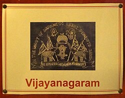
[[File:Vijayanagaram.JPG|thumb|[[Coat of arms]] of the Vizianagaram kingdom]] | [[File:Vijayanagaram.JPG|thumb|[[Coat of arms]] of the Vizianagaram kingdom]] | ||
Excavations at this town revealed copper coins belonging to the remains of 900 [[Before Christ|B.C.]] (Kalinga period).<ref>{{cite web |title=Welcome to Vizianagaram Municipality |url=http://cdma.ap.gov.in/VIZIANAGARAM/ |publisher=Municipal Administration & Urban Development Department, Govt. of Andhra Pradesh |access-date=23 October 2014 |archive-url=https://web.archive.org/web/20140810142240/http://cdma.ap.gov.in/VIZIANAGARAM/ |archive-date=10 August 2014 |url-status=live}}</ref> | |||
Vizianagaram Princely State was ruled by Pusapati Kings & Gajapati Maharajas. Maharaja Vijayarama Gajapati Raju was a notable King. | |||
Pusapatis are decendants of Lord Shri Rama. They are SuryaVamshi Kshatriyas. Their ancestors are Udaipur Maharanas. | |||
== Geography == | == Geography == | ||
Vizianagaram is located at {{Coord|18.12|N|83.42|E|}}. It has an average elevation of 74 metres (242 feet). | |||
Vizianagaram is located at {{Coord|18.12|N|83.42|E|}}. It has an average elevation of 74 metres (242 feet) | |||
=== Climate === | === Climate === | ||
[[File:Sunset at Vizianagaram town.jpg|thumb|Sunset at Vizianagaram]] | [[File:Sunset at Vizianagaram town.jpg|thumb|Sunset at Vizianagaram]] | ||
Vizianagaram has a [[tropical savanna climate]] ([[Köppen climate classification]] ''Aw'') characterised by high [[humidity]] nearly | Vizianagaram has a [[tropical savanna climate]] ([[Köppen climate classification]] ''Aw'') characterised by high [[humidity]] nearly year-round, with oppressive summers and good seasonal rainfall.<ref>{{Cite web |title=About Vizianagaram {{!}} JNTUK |url=https://jntukucev.ac.in/know-ucev/about-vizianagaram/ |access-date=2023-02-13 |language=en-US}}</ref> The summer season extends from March to May, followed by [[monsoon]] season, which continues to September. October and November constitute the post-monsoon or retreating monsoon season. The normal rainfall of the district for the year is 1,131.0 mm, as compared to the actual rainfall of 740.6 mm received during 2002–2003. The district gets the benefit of both the southwest and northeast monsoon. The season from December to February generally has fine weather.<ref>{{Cite web |last=Atlas |first=Weather |title=Vizianagaram, India - Climate & Monthly weather forecast |url=https://www.weather-atlas.com/en/india/vizianagaram-climate |access-date=2023-02-13 |website=Weather Atlas |language=en}}</ref> | ||
{{Weather box | {{Weather box | ||
| location = Vizianagaram, Andhra Pradesh | | location = Vizianagaram, Andhra Pradesh | ||
| Line 164: | Line 155: | ||
}}</ref> | }}</ref> | ||
}} | }} | ||
== Demographics == | == Demographics == | ||
As of the [[2011 Census of India]], the town had a population of 227,533. The total population constituted 111,596 males and 115,937 females—a sex ratio of 1,039 females per 1,000 males, higher than the national average of 940 per 1,000.<ref name=population>{{cite web|url=http://www.citypopulation.de/php/india-andhrapradesh.php|title=Andhra Pradesh (India): Districts, Cities, Towns and Outgrowth Wards – Population Statistics in Maps and Charts|work=citypopulation.de|access-date=2 October 2015|archive-url=https://web.archive.org/web/20160724215047/http://www.citypopulation.de/php/india-andhrapradesh.php|archive-date=24 July 2016|url-status=live}}</ref><ref>{{cite web|title=Sex Ratio|url=http://censusindia.gov.in/2011-prov-results/indiaatglance.html|publisher=The Registrar General & Census Commissioner, India|access-date=2 September 2014|archive-url=https://web.archive.org/web/20140922103426/http://censusindia.gov.in/2011-prov-results/indiaatglance.html|archive-date=22 September 2014|url-status=live}}</ref> 20,487 children are in the age group of 0–6 years, of which 10,495 are boys and 9,992 are girls. The average literacy rate stood at 81.85% with 169,461 literates, significantly higher than the national average of 73.00%.<ref name=population /><ref>{{cite web|title=Chapter–3 (Literates and Literacy rate)|url=http://www.censusindia.gov.in/2011census/PCA/PCA_Highlights/pca_highlights_file/India/Chapter-3.pdf|publisher=Registrar General and Census Commissioner of India|access-date=2 September 2014|format=PDF|archive-url=https://web.archive.org/web/20131113231419/http://www.censusindia.gov.in/2011census/PCA/PCA_Highlights/pca_highlights_file/India/Chapter-3.pdf|archive-date=13 November 2013|url-status=live}}</ref> | |||
Telugu is the official language. | Telugu is the official language. | ||
| Line 174: | Line 165: | ||
=== Civic administration === | === Civic administration === | ||
The Vizianagaram Municipal Corporation is the civic body of the city, constituted as a [[municipality]] in 1888<ref name="ulb">{{cite web |title=Statistical Information of ULBs and UDAs |url=http://www.dtcp.ap.gov.in/dtcpweb/ulbs/List%20of%20ULBs-27-2-2019.pdf |website=Directorate of Town and Country Planning |publisher=Government of Andhra Pradesh |access-date=10 June 2019 |page=1 |format=PDF |date=27 February 2019 |archive-url=https://web.archive.org/web/20190717151418/http://dtcp.ap.gov.in/dtcpweb/ulbs/List%20of%20ULBs-27-2-2019.pdf |archive-date=17 July 2019 |url-status=live }}</ref> before being upgraded to corporation on 9 December 2015.<ref>{{cite news|title=Masula, Srikakulam, Vizianagaram upgraded into corporations|url=http://www.thehindu.com/news/cities/Vijayawada/masula-srikakulam-vizianagaram-upgraded-into-corporations/article7967915.ece|access-date=10 December 2015|work=The Hindu|date=10 December 2015|archive-url=https://web.archive.org/web/20160409032222/http://www.thehindu.com/news/cities/vijayawada/masula-srikakulam-vizianagaram-upgraded-into-corporations/article7967915.ece|archive-date=9 April 2016|location=Vijayawada}}</ref> The jurisdictional area of the corporation is spread over {{convert|29.27|km2|mi2|abbr=on}} with 38 [[Ward (electoral subdivision)|election wards]].<ref name="ulb" /> During 2010–11, the municipality spent {{INRConvert|1887.75|c|abbr=on}} and generated {{INRConvert|2367.51|c|abbr=on}}.<ref name="basic info">{{cite web|title=Basic Information of Municipality|url=http://cdma.ap.gov.in/VIZIANAGARAM/Basic_information_Municipality.html|website=Commissioner & Director of Municipal Administration|publisher=Municipal Administration & Urban Development Department, Govt. of Andhra Pradesh|access-date=3 September 2014|archive-url=https://web.archive.org/web/20140810145501/http://cdma.ap.gov.in/VIZIANAGARAM/Basic_information_Municipality.html|archive-date=10 August 2014|url-status=dead}}</ref> | |||
Vizianagaram | |||
=== Utility services === | === Utility services === | ||
[[File:SH 26 in Vizianagaram.jpg|thumb|SH-26 towards [[Visakhapatnam]] in Vizianagaram]] | [[File:SH 26 in Vizianagaram.jpg|thumb|SH-26 towards [[Visakhapatnam]] in Vizianagaram]] | ||
Utility services include a water supply, sewer connections, drainage systems, parks, grounds, community centres, and healthcare. The municipality maintains 458 public taps, 749 bore–wells, {{convert|330|km|mi|abbr=on}} of roads, {{convert|243.25|km|mi|abbr=on}} of drains, 32 parks, 2 playgrounds, 49 elementary and 3 secondary schools and 1 maternity and child health centre.<ref>{{cite web|title=Public services/amenities|url=http://cdma.ap.gov.in/VIZIANAGARAM/Public%20services_amenities.html|website=Commissioner & Director of Municipal Administration|publisher=Municipal Administration & Urban Development Department, Govt. of Andhra Pradesh|access-date=3 September 2014|archive-url=https://web.archive.org/web/20141202102522/http://cdma.ap.gov.in/VIZIANAGARAM/Public%20services_amenities.html|archive-date=2 December 2014|url-status=live}}</ref> | |||
== Transport == | == Transport == | ||
| Line 201: | Line 176: | ||
=== Roadways === | === Roadways === | ||
The city has a total road length of 317.80 km.<ref>{{cite web|url=http://centralapp.cdma.ap.gov.in:8080/CDMAAPTaxesInfo/RoadDetails.jsp|title=DETAILS OF ROADS IN EACH ULB OF ANDHRA PRADESH|access-date=28 March 2017|archive-url=https://web.archive.org/web/20160801101300/http://centralapp.cdma.ap.gov.in:8080/CDMAAPTaxesInfo/RoadDetails.jsp|archive-date=1 August 2016|url-status=dead|df=dmy-all}}</ref> The [[Andhra Pradesh State Road Transport Corporation]] operates bus services from Vizianagaram bus station.<ref>{{cite web|title=Bus Stations in Districts |url=http://www.apsrtc.gov.in/Bus%20Stations.aspx |website=Andhra Pradesh State Road Transport Corporation |access-date=9 March 2016 |url-status=dead |archive-url=https://web.archive.org/web/20160322233330/http://apsrtc.gov.in/Bus%20Stations.aspx |archive-date=22 March 2016 }}</ref> | The city has a total road length of 317.80 km.<ref>{{cite web|url=http://centralapp.cdma.ap.gov.in:8080/CDMAAPTaxesInfo/RoadDetails.jsp|title=DETAILS OF ROADS IN EACH ULB OF ANDHRA PRADESH|access-date=28 March 2017|archive-url=https://web.archive.org/web/20160801101300/http://centralapp.cdma.ap.gov.in:8080/CDMAAPTaxesInfo/RoadDetails.jsp|archive-date=1 August 2016|url-status=dead|df=dmy-all}}</ref> The [[Andhra Pradesh State Road Transport Corporation]] operates bus services from Vizianagaram bus station.<ref>{{cite web|title=Bus Stations in Districts |url=http://www.apsrtc.gov.in/Bus%20Stations.aspx |website=Andhra Pradesh State Road Transport Corporation |access-date=9 March 2016 |url-status=dead |archive-url=https://web.archive.org/web/20160322233330/http://apsrtc.gov.in/Bus%20Stations.aspx |archive-date=22 March 2016 }}</ref> | ||
== Educational == | == Educational == | ||
The primary and secondary school education is imparted by government, aided and private schools of the ''School Education Department'' of the state.<ref>{{cite web|title=School Education Department |url=http://rmsaap.nic.in/Notification_TSG_2015.pdf |publisher=School Education Department, Government of Andhra Pradesh |access-date=7 November 2016 |format=PDF |url-status=dead |archive-url=https://web.archive.org/web/20160319051231/http://rmsaap.nic.in/Notification_TSG_2015.pdf |archive-date=19 March 2016 }}</ref><ref>{{cite web|title=The Department of School Education – Official AP State Government Portal {{!}} AP State Portal |url=http://www.ap.gov.in/department/organizations/school-education/ |website=www.ap.gov.in |access-date=7 November 2016 |url-status=dead |archive-url=https://web.archive.org/web/20161107155331/http://www.ap.gov.in/department/organizations/school-education/ |archive-date= 7 November 2016 }}</ref> | The primary and secondary school education is imparted by government, aided and private schools of the ''School Education Department'' of the state.<ref>{{cite web|title=School Education Department |url=http://rmsaap.nic.in/Notification_TSG_2015.pdf |publisher=School Education Department, Government of Andhra Pradesh |access-date=7 November 2016 |format=PDF |url-status=dead |archive-url=https://web.archive.org/web/20160319051231/http://rmsaap.nic.in/Notification_TSG_2015.pdf |archive-date=19 March 2016 }}</ref><ref>{{cite web|title=The Department of School Education – Official AP State Government Portal {{!}} AP State Portal |url=http://www.ap.gov.in/department/organizations/school-education/ |website=www.ap.gov.in |access-date=7 November 2016 |url-status=dead |archive-url=https://web.archive.org/web/20161107155331/http://www.ap.gov.in/department/organizations/school-education/ |archive-date= 7 November 2016 }}</ref> | ||
Vizianagaram has educational institutions, including: | |||
* [[Maharajah's College]] | |||
* [[Maharajah's Government College of Music and Dance]] | |||
* [[MVGR College of Engineering]] | |||
* [[Andhra University]] – Vizianagaram Campus | |||
== See also == | == See also == | ||
| Line 240: | Line 195: | ||
== External links == | == External links == | ||
* [http://vizianagaram.nic.in/ Vizianagaram official website] | * [http://vizianagaram.nic.in/ Vizianagaram official website] | ||
| Line 247: | Line 202: | ||
{{Mandal headquarters in Vizianagaram district}} | {{Mandal headquarters in Vizianagaram district}} | ||
{{Nobility of the Raj}} | {{Nobility of the Raj}} | ||
{{Authority control}} | {{Authority control}} | ||
| Line 253: | Line 209: | ||
[[Category:District headquarters of Andhra Pradesh]] | [[Category:District headquarters of Andhra Pradesh]] | ||
[[Category:Mandal headquarters in Vizianagaram district]] | [[Category:Mandal headquarters in Vizianagaram district]] | ||
[[Category:Quasi-princely estates of India]] | |||
[[Category:Towns in Vizianagaram district]] | [[Category:Towns in Vizianagaram district]] | ||
[[Category: | [[Category:Zamindari estates]] | ||
Revision as of 07:46, 22 July 2023
Vizianagaram
Vijayanagaram | |
|---|---|
| Vizianagaram | |
 Clockwise from Top Left: Clock Tower (Ganta stambham), Vizianagaram Fort Balcony, View of Vizianagaram Town, Writings of the great writer Gurajada Apparao, Vizianagaram Fort Walls, Replica of a steam engine at Vizianagaram railway station | |
| Nickname: Vizianagaram | |
  Vizianagaram Location in Andhra Pradesh, India | |
| Coordinates: 18°06′57″N 83°24′22″E / 18.1159°N 83.406°E | |
| Country | India |
| State | Andhra Pradesh |
| District | Vizianagaram |
| Incorporated (Municipality) | 1888 |
| Founded by | Vijayaram Raj |
| Wards | 50 |
| Government | |
| • Type | Mayor–Council |
| • Body | Vizianagaram Municipal Corporation Visakhapatnam Metropolitan Region Development Authority |
| • MLAs | Veera Bhadra Swamy Kolagatla |
| • MP | Bellana Chandra Sekhar |
| Area | |
| • Total | 29.27 km2 (11.30 sq mi) |
| Population (2011)[2] | |
| • Total | 228,025 |
| • Rank | 11th (in AP) |
| Literacy | |
| Languages | |
| • Official | Telugu |
| Time zone | UTC+5:30 (IST) |
| PIN | 535001 - 535006 |
| Area code | +91–8922 |
| Vehicle Registration | AP35 (Former) AP39 (from 30 January 2019)[3] |
| Website | https://vizianagaram.ap.gov.in/public-utility-category/municipality/ |
Vizianagaram or Vijayanagaram is a city and the headquarters of the Vizianagaram district in the Indian state of Andhra Pradesh.[5] It is located in the Eastern Ghats, about 24 km (15 mi) west of the Bay of Bengal and 40 km (25 mi) north-northeast of Visakhapatnam. The city has a population of 228,025 and was established as the capital of the Vizianagaram estate by Raja Vijayaram Raj from the Pusapati dynasty. The rulers had a notable role in the history of the region in the 18th century and were patrons of education and arts.[6]

History

Excavations at this town revealed copper coins belonging to the remains of 900 B.C. (Kalinga period).[7]
Vizianagaram Princely State was ruled by Pusapati Kings & Gajapati Maharajas. Maharaja Vijayarama Gajapati Raju was a notable King. Pusapatis are decendants of Lord Shri Rama. They are SuryaVamshi Kshatriyas. Their ancestors are Udaipur Maharanas.
Geography
Vizianagaram is located at 18°07′N 83°25′E / 18.12°N 83.42°E. It has an average elevation of 74 metres (242 feet).
Climate

Vizianagaram has a tropical savanna climate (Köppen climate classification Aw) characterised by high humidity nearly year-round, with oppressive summers and good seasonal rainfall.[8] The summer season extends from March to May, followed by monsoon season, which continues to September. October and November constitute the post-monsoon or retreating monsoon season. The normal rainfall of the district for the year is 1,131.0 mm, as compared to the actual rainfall of 740.6 mm received during 2002–2003. The district gets the benefit of both the southwest and northeast monsoon. The season from December to February generally has fine weather.[9]
| Climate data for Vizianagaram, Andhra Pradesh | |||||||||||||
|---|---|---|---|---|---|---|---|---|---|---|---|---|---|
| Month | Jan | Feb | Mar | Apr | May | Jun | Jul | Aug | Sep | Oct | Nov | Dec | Year |
| Average high °C (°F) | 27.6 (81.7) |
29.4 (84.9) |
32.1 (89.8) |
33.8 (92.8) |
34.8 (94.6) |
33.9 (93.0) |
31.6 (88.9) |
31.5 (88.7) |
31.4 (88.5) |
31.0 (87.8) |
29.0 (84.2) |
27.3 (81.1) |
31.1 (88.0) |
| Average low °C (°F) | 18.2 (64.8) |
20.6 (69.1) |
23.4 (74.1) |
25.8 (78.4) |
27.5 (81.5) |
27.2 (81.0) |
26.0 (78.8) |
25.9 (78.6) |
25.5 (77.9) |
24.4 (75.9) |
21.0 (69.8) |
18.4 (65.1) |
23.7 (74.6) |
| Average rainfall mm (inches) | 11 (0.4) |
7 (0.3) |
11 (0.4) |
19 (0.7) |
77 (3.0) |
132 (5.2) |
157 (6.2) |
172 (6.8) |
204 (8.0) |
245 (9.6) |
57 (2.2) |
5 (0.2) |
1,097 (43) |
| Source: Climate-Data.org[10] | |||||||||||||
Demographics
As of the 2011 Census of India, the town had a population of 227,533. The total population constituted 111,596 males and 115,937 females—a sex ratio of 1,039 females per 1,000 males, higher than the national average of 940 per 1,000.[11][12] 20,487 children are in the age group of 0–6 years, of which 10,495 are boys and 9,992 are girls. The average literacy rate stood at 81.85% with 169,461 literates, significantly higher than the national average of 73.00%.[11][13]
Telugu is the official language.
Governance
Civic administration
The Vizianagaram Municipal Corporation is the civic body of the city, constituted as a municipality in 1888[14] before being upgraded to corporation on 9 December 2015.[15] The jurisdictional area of the corporation is spread over 29.27 km2 (11.30 sq mi) with 38 election wards.[14] During 2010–11, the municipality spent ₹1,887.75 crore (US$260 million) and generated ₹2,367.51 crore (US$330 million).[16]
Utility services

Utility services include a water supply, sewer connections, drainage systems, parks, grounds, community centres, and healthcare. The municipality maintains 458 public taps, 749 bore–wells, 330 km (210 mi) of roads, 243.25 km (151.15 mi) of drains, 32 parks, 2 playgrounds, 49 elementary and 3 secondary schools and 1 maternity and child health centre.[17]
Transport


Roadways
The city has a total road length of 317.80 km.[18] The Andhra Pradesh State Road Transport Corporation operates bus services from Vizianagaram bus station.[19]
Educational
The primary and secondary school education is imparted by government, aided and private schools of the School Education Department of the state.[20][21]
Vizianagaram has educational institutions, including:
- Maharajah's College
- Maharajah's Government College of Music and Dance
- MVGR College of Engineering
- Andhra University – Vizianagaram Campus
See also
References
- ↑ "Basic Information of Municipality". Commissioner & Director of Municipal Administration. Municipal Administration & Urban Development Department, Govt. of Andhra Pradesh. Archived from the original on 10 August 2014. Retrieved 5 August 2014.
- ↑ "Statistical Abstract of Andhra Pradesh, 2015" (PDF). Directorate of Economics & Statistics. Government of Andhra Pradesh. p. 44. Archived from the original (PDF) on 14 July 2019. Retrieved 27 April 2019.
- ↑ "New 'AP 39' code to register vehicles in Andhra Pradesh launched". The New Indian Express. Vijayawada. 31 January 2019. Retrieved 9 June 2019.
- ↑ "District Census Hand Book : Vizianagaram (Part B)" (PDF). Census of India. Directorate of Census Operations, Andhra Pradesh. 2011. pp. 16, 48. Archived (PDF) from the original on 29 August 2017. Retrieved 10 June 2019.
- ↑ "District Census Hand Book : Vizianagaram (Part A)" (PDF). Census of India. Directorate of Census Operations, Andhra Pradesh. 2011. pp. 11, 992–993. Archived (PDF) from the original on 14 November 2016. Retrieved 10 June 2019.
- ↑ "Vizianagaram | India". Encyclopedia Britannica. Archived from the original on 27 November 2019. Retrieved 27 November 2019.
- ↑ "Welcome to Vizianagaram Municipality". Municipal Administration & Urban Development Department, Govt. of Andhra Pradesh. Archived from the original on 10 August 2014. Retrieved 23 October 2014.
- ↑ "About Vizianagaram | JNTUK". Retrieved 13 February 2023.
- ↑ Atlas, Weather. "Vizianagaram, India - Climate & Monthly weather forecast". Weather Atlas. Retrieved 13 February 2023.
- ↑ "Climate: vizianagaram". Archived from the original on 2 March 2016. Retrieved 19 February 2016.
- ↑ 11.0 11.1 "Andhra Pradesh (India): Districts, Cities, Towns and Outgrowth Wards – Population Statistics in Maps and Charts". citypopulation.de. Archived from the original on 24 July 2016. Retrieved 2 October 2015.
- ↑ "Sex Ratio". The Registrar General & Census Commissioner, India. Archived from the original on 22 September 2014. Retrieved 2 September 2014.
- ↑ "Chapter–3 (Literates and Literacy rate)" (PDF). Registrar General and Census Commissioner of India. Archived (PDF) from the original on 13 November 2013. Retrieved 2 September 2014.
- ↑ 14.0 14.1 "Statistical Information of ULBs and UDAs" (PDF). Directorate of Town and Country Planning. Government of Andhra Pradesh. 27 February 2019. p. 1. Archived (PDF) from the original on 17 July 2019. Retrieved 10 June 2019.
- ↑ "Masula, Srikakulam, Vizianagaram upgraded into corporations". The Hindu. Vijayawada. 10 December 2015. Archived from the original on 9 April 2016. Retrieved 10 December 2015.
- ↑ "Basic Information of Municipality". Commissioner & Director of Municipal Administration. Municipal Administration & Urban Development Department, Govt. of Andhra Pradesh. Archived from the original on 10 August 2014. Retrieved 3 September 2014.
- ↑ "Public services/amenities". Commissioner & Director of Municipal Administration. Municipal Administration & Urban Development Department, Govt. of Andhra Pradesh. Archived from the original on 2 December 2014. Retrieved 3 September 2014.
- ↑ "DETAILS OF ROADS IN EACH ULB OF ANDHRA PRADESH". Archived from the original on 1 August 2016. Retrieved 28 March 2017.
- ↑ "Bus Stations in Districts". Andhra Pradesh State Road Transport Corporation. Archived from the original on 22 March 2016. Retrieved 9 March 2016.
- ↑ "School Education Department" (PDF). School Education Department, Government of Andhra Pradesh. Archived from the original (PDF) on 19 March 2016. Retrieved 7 November 2016.
- ↑ "The Department of School Education – Official AP State Government Portal | AP State Portal". www.ap.gov.in. Archived from the original on 7 November 2016. Retrieved 7 November 2016.