

imported>ANKAN |
robot: Update article (please report if you notice any mistake or error in this edit) |
||
| Line 3: | Line 3: | ||
{{Use Indian English|date=January 2019}} | {{Use Indian English|date=January 2019}} | ||
{{Infobox settlement | {{Infobox settlement | ||
| name | | name = Namchi | ||
| native_name | | native_name = | ||
| native_name_lang | | native_name_lang = | ||
| other_name | | other_name = | ||
| settlement_type | | settlement_type = [[List of cities in India by population|City]] | ||
| image_skyline | | image_skyline = {{multiple image | ||
| image_alt | | border = infobox | ||
| image_caption | | total_width = 290 | ||
| nickname | | image_style = | ||
| pushpin_map | | perrow = 1/2/2/2 | ||
| pushpin_label_position | | image5 = Namchi.jpg | ||
| pushpin_map_alt | | image2= Ravangla Buddha Park, Sikkim.jpg | ||
| pushpin_map_caption | | image3 = Panoramic view of large statue of Guru Padmasambhava (Guru Rinpoche)m Namchi.jpg | ||
| coordinates | | image6= Sai Temple in Namchi, Sikkim.jpg | ||
| subdivision_type | | image4 = Cherry Resort inside Temi Tea Garden, Namchi, Sikkim.jpg | ||
| subdivision_name | | image7= Temi tea garden.jpg | ||
| subdivision_type1 | | image1 = Siddheshwar Dham.jpg | ||
| subdivision_type2 | }} | ||
| subdivision_name1 | | image_alt = | ||
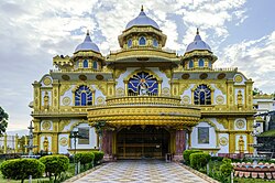
| subdivision_name2 | | image_caption = '''Clockwise from top:'''<br/> Siddheshwar Dham in Namchi, Guru Rinpochem statue, Central park, Temi tea garden, Sai temple, Cherry resort in tea garden, Buddha Park | ||
| established_title | | nickname = | ||
| established_date | | pushpin_map = India Sikkim#India3 | ||
| founder | | pushpin_label_position = left | ||
| named_for | | pushpin_map_alt = | ||
| government_type | | pushpin_map_caption = Location of Namchi in Sikkim | ||
| coordinates = {{coord|27.17|N|88.35|E|display=inline,title}} | |||
| governing_body | | subdivision_type = [[List of sovereign states|Country]] | ||
| unit_pref | | subdivision_name = {{Flag|India}} | ||
| area_footnotes | | subdivision_type1 = [[States and union territories of India|State]] | ||
| area_total_km2 | | subdivision_type2 = [[List of districts in India|District]] | ||
| area_rank | | subdivision_name1 = {{flagicon image|Flag of the Government of Sikkim.svg}} [[Sikkim]] | ||
| elevation_footnotes | | subdivision_name2 = [[South Sikkim|Namchi]] | ||
| elevation_m | | established_title = <!-- Established --> | ||
| population_total | | established_date = | ||
| population_as_of | | founder = | ||
| population_footnotes | | named_for = | ||
| population_density_km2 | | government_type = [[Municipal Council (India)|Municipal Council]] | ||
| population_rank | | governing_body = | ||
| population_demonym | | unit_pref = Metric | ||
| demographics_type1 | | area_footnotes = | ||
| demographics1_title1 | | area_total_km2 = | ||
| timezone1 | | area_rank = | ||
| utc_offset1 | | elevation_footnotes = | ||
| postal_code_type | | elevation_m = 1315 | ||
| postal_code | | population_total = 12194 | ||
| area_code | | population_as_of = 2001 | ||
| area_code_type | | population_footnotes = | ||
| registration_plate | | population_density_km2 = auto | ||
| blank_name_sec1 | | population_rank = | ||
| blank_info_sec1 | | population_demonym = | ||
| website | | demographics_type1 = Languages | ||
| footnotes | | demographics1_title1 = Official | ||
| demographics1_info1 | | timezone1 = [[Indian Standard Time|IST]] | ||
| utc_offset1 = +5:30 | |||
| postal_code_type = [[Postal Index Number|PIN]] | |||
| postal_code = 737 126 | |||
| area_code = 03595 | |||
| area_code_type = Telephone code | |||
| registration_plate = SK 05 | |||
| blank_name_sec1 = | |||
| blank_info_sec1 = | |||
| website = | |||
| footnotes = | |||
| demographics1_info1 = [[Nepali language|Nepali]], [[Bhutia language|Bhutia]], [[Lepcha language|Lepcha]], [[Limbu language|Limbu]], [[Newari language|Newari]], [[Rai languages|Rai]], [[Gurung language|Gurung]], Mangar, [[Sherpa language|Sherpa]], [[Tamang language|Tamang]] and [[Sunwar language|Sunwar]] | |||
}} | }} | ||
'''Namchi | '''Namchi'''<ref name = NIC>{{cite web|url=http://sikkim.nic.in/sws/poi_sou.htm|title=South Skikkim|publisher=[[National Informatics Centre]]|access-date=12 August 2015}}</ref> is a [[city]] and the administrative headquarter of the [[South Sikkim district|Namchi district]] in the [[India]]n [[states and union territories of India|state]] of [[Sikkim]]. The appellation Namchi means ''Sky (Nam) High (Chi)'' in [[Sikkimese language|Sikkimese]].<ref name = NIC /> | ||
== Geography == | == Geography == | ||
Namchi is located at {{coord|27.17|N|88.35|E|}}.<ref>[http://www.fallingrain.com/world/IN/0/Namchi.html Falling Rain Genomics, Inc - Namchi]</ref> It has an average elevation of {{convert|1315|m}}. | Namchi is located at {{coord|27.17|N|88.35|E|}}.<ref>[http://www.fallingrain.com/world/IN/0/Namchi.html Falling Rain Genomics, Inc - Namchi]</ref> It has an average elevation of {{convert|1315|m}}. | ||
Namchi is situated at an altitude of 1,675 m (5500 feet) above [[sea level]]. It is situated at a distance of {{convert|78|km}} from the state capital [[Gangtok]] and {{convert|100|km}} from the town of [[Siliguri]],<ref name = NIC /> the nearest railhead and airport. Namchi lies off the road between [[Melli]] and [[Jorethang]]. Namchi is well connected to other towns in Sikkim and [[West Bengal]]. [[Jeep]]s and buses regularly ply between Namchi to | Namchi is situated at an altitude of 1,675 m (5500 feet) above [[sea level]]. It is situated at a distance of {{convert|78|km}} from the state capital [[Gangtok]] and {{convert|100|km}} from the town of [[Siliguri]],<ref name = NIC /> the nearest railhead and airport. Namchi lies off the road between [[Melli]] and [[Jorethang]]. Namchi is well connected to other towns in Sikkim and [[West Bengal]]. [[Jeep]]s and buses regularly ply between Namchi to Gangtok, [[Pelling]], Jorethang, [[Kalimpong]] and Siliguri. | ||
It is home of the | It is home of the Buxa Formation of Mamley, the [[stromatolite]] bearing [[Dolomite (rock)|Dolomite]] Limestones, which has been declared [[List of National Geological Monuments in India|national geological monument]] by the [[Geological Survey of India]] (GSI), for their protection, maintenance, promotion and enhancement of [[geotourism]].<ref name=gsi1>{{Cite web |url=http://www.portal.gsi.gov.in/portal/page?_pageid=127,529542&_dad=portal&_schema=PORTAL |title=National Geological Monument, from Geological Survey of India website |access-date=21 January 2019 |archive-url=https://web.archive.org/web/20170712055947/http://www.portal.gsi.gov.in/portal/page?_pageid=127,529542&_dad=portal&_schema=PORTAL |archive-date=12 July 2017 |url-status=dead }}</ref><ref name="gsi2">{{Cite web|url=http://pib.nic.in/newsite/PrintRelease.aspx?relid=137573|title=Geo-Heritage Sites|date=2016-03-09|website=pib.nic.in|publisher=[[Press Information Bureau]]|access-date=2018-09-15}}</ref><ref name=gsi3>[http://naturalheritage.intach.org/wp-content/uploads/2016/09/Geoheritage-Monograph.pdf national geo-heritage of India], [[Indian National Trust for Art and Cultural Heritage|INTACH]]</ref> | ||
===Mamley national geological monument=== | ===Mamley national geological monument=== | ||
{{anchor | Mamley | Geo | Geological | Monument | National monument | National geological monument | Mamley national geological monument }} | |||
{{see also | National Geological Monuments of India }} | |||
Buxa Formation of Mamley<!-- Per wiki guidelines, retain redlink to encourage creation. Redirect it to Mamley Stromatolite Park.--> (also called '''Mamley Stromatolite Park''')<!-- Per wiki guidelines, retain redlink to encourage creation.--> in Mamley<!-- Per wiki guidelines, retain redlink to encourage creation. -->, the stromatolite bearing Dolomite Limestones has been declared [[List of National Geological Monuments in India|national geological monument]] by the [[Geological Survey of India]] (GSI), for their protection, maintenance, promotion and enhancement of [[geotourism]].<ref name=gsi1/><ref name="gsi2"/><ref name=gsi3/> It is contiguous to the [[Buxa Tiger Reserve]] in neighboring state of [[West Bengal]]. | |||
== Demographics == | == Demographics == | ||
{{ | {{update after|2022}} | ||
As of the [[2011 Census of India]],<ref>{{cite web|url=http://www.censusindia.net/results/town.php?stad=A&state5=999|archive-url=https://web.archive.org/web/20040616075334/http://www.censusindia.net/results/town.php?stad=A&state5=999|archive-date=2004-06-16|title= Census of India 2001: Data from the 2001 Census, including cities, villages and towns (Provisional)|access-date=2008-11-01|publisher= Census Commission of India}}</ref> Namchi has a population of 12194. Males constitute 52% of the population and females 48%. Namchi has an average literacy rate of 78%, higher than the national average of 59.5%: male literacy is 81%, and female literacy is 73%. In Namchi, 9% of the population is under 6 years of age. | |||
Most of the people of Namchi are [[Hindu]]s and [[Buddhist]]s. Languages spoken are [[Nepali language|Nepali]]. | Most of the people of Namchi are [[Hindu]]s and [[Buddhist]]s. Languages spoken are [[Nepali language|Nepali]]. | ||
== Education == | == Education == | ||
Namchi has more than half a dozen private schools with quality education (Mt. Carmel School, Namchi Public School, Tendong Educational Institute, New Light Academy, Bethany School etc.) and government higher secondary schools for boys and girls and prominent computer institutes e.g. Informatics Computer Institute (under Government of Sikkim Registered) Multimedia Computer Institute an authorized study center of Manipal Group etc. Just few kilometers away from the town is a reputed Government College for Arts, Education, Science, Commerce. People give a lot of importance and focus on education with a reverence. Namchi Public School, run by Catholic missionaries, is one of the respected educational institutes in the state and one of the best in the south district of Sikkim. | Namchi has more than half a dozen private schools with quality education (Seven Hills School, Mt. Carmel School, Namchi Public School, Tendong Educational Institute, New Light Academy, Bethany School etc.<ref>{{Cite web |title=Schools in Namchi Sss Cluster {{!}} List of Schools in Namchi Sss Cluster, South Sikkim District (Sikkim) |url=https://schools.org.in/sikkim/south-sikkim/namchi-/namchi--sss |access-date=2022-05-21 |website=schools.org.in |language=en}}</ref>) and government higher secondary schools for boys and girls and prominent computer institutes e.g. Informatics Computer Institute (under Government of Sikkim Registered) Multimedia Computer Institute an authorized study center of Manipal Group etc. Just few kilometers away from the town is a reputed Government College for Arts, Education, Science, Commerce. People give a lot of importance and focus on education with a reverence. Namchi Public School, run by Catholic missionaries, is one of the respected educational institutes in the state and one of the best in the south district of Sikkim.{{citation needed|date=May 2022}} | ||
== Tourism == | == Tourism == | ||
| Line 83: | Line 97: | ||
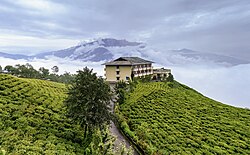
[[File:Cherry Resort inside Temi Tea Garden, Namchi, Sikkim.jpg|thumb|Cherry Resort inside Temi Tea Garden, Namchi, Sikkim]] | [[File:Cherry Resort inside Temi Tea Garden, Namchi, Sikkim.jpg|thumb|Cherry Resort inside Temi Tea Garden, Namchi, Sikkim]] | ||
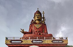
Namchi is fast becoming a tourist spot and pilgrimage centre.{{citation needed|date=May 2018}} The [[Namchi Monastery]], [[Ralang Monastery]] and Tendong Hill are local [[Buddhist]] pilgrimage centres. The world's largest statue (at 118 feet) of the [[Buddhist]] [[Padmasambhava]],{{citation needed|date=June 2021}} also known as Guru Rinpoche, the patron saint of Sikkim, is on the Samdruptse hill (The Wish Fulfilling hill) opposite Namchi. It was completed in February 2004. It is also said that the Samdruptse hill is actually a dormant volcano. Myths say that the Buddhist monks have been going on top of the hill and offering prayers to the volcano to keep it calm. There is also a Rock Garden a few kilometers from the town on the way to Samdruptse. The area has views of Mt. Kanchendzonga, aka [[Kangchenjunga|Mt. Kangchenjunga]], the world's third highest peak. | Namchi is fast becoming a tourist spot and pilgrimage centre.{{citation needed|date=May 2018}} The [[Namchi Monastery]], [[Ralang Monastery]] and [[Tendong Gumpa|Tendong Hill]] are local [[Buddhist]] pilgrimage centres. The world's largest statue (at 118 feet) of the [[Buddhist]] [[Padmasambhava]],{{citation needed|date=June 2021}} also known as Guru Rinpoche, the patron saint of Sikkim, is on the Samdruptse hill (The Wish Fulfilling hill) opposite Namchi. It was completed in February 2004. It is also said that the Samdruptse hill is actually a dormant volcano. Myths say that the Buddhist monks have been going on top of the hill and offering prayers to the volcano to keep it calm. There is also a Rock Garden a few kilometers from the town on the way to Samdruptse. The area has views of Mt. Kanchendzonga, aka [[Kangchenjunga|Mt. Kangchenjunga]], the world's third highest peak. | ||
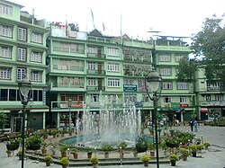
[[File:Namchi.jpg|thumb|left|Central Park, Namchi]] | [[File:Namchi.jpg|thumb|left|Central Park, Namchi]] | ||
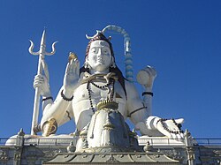
Recently inaugurated (in November 2011), the Siddhesvara Dhaam is a pilgrimage-tourism venture of the Sikkim Government developed as "Pilgrim cum Cultural Centre" boasting an 87-ft statue of [[Shiva|Lord Shiva]] and replicas of four | Recently inaugurated (in November 2011), the Siddhesvara Dhaam is a pilgrimage-tourism venture of the Sikkim Government developed as "Pilgrim cum Cultural Centre" boasting an 87-ft statue of [[Shiva|Lord Shiva]] and replicas of four Dhams of the country, all at one place on the Solophok hilltop in Namchi. [[Char Dham]], the four most revered Dhams of the Hindus have been replicated in this fantastic complex to benefit the devotees and tourists. The dream project of Chief Minister [[Pawan Chamling]] which was conceived by him and started in the year 2005 stands promisingly amidst the breathtaking surrounding of Solophok hill, befitting the mythological setting behind the establishment of the original Dhams. For the consecration of the Dham Shri Jagadguru Sankaryacharya Swami Swarupananda Saraswati, in the presence of the Chief Minister Shri Pawan Chamling and his wife Smt Tika Maya Chamling, did the "Pran Prastisha" of the Dham. | ||
[[File:Lordshiva.JPG|thumb|This is the statue of Lord Shiva at Siddhesvara Dhaam in Namchi, Sikkim]] | [[File:Lordshiva.JPG|thumb|This is the statue of Lord Shiva at Siddhesvara Dhaam in Namchi, Sikkim]] | ||
There are replicas of the "Dwadash Jyotirlingas" (the twelve jyothirlingas) of Somnath, Mallikarjuna, Mahakaleswar, Omkareshwar, Kedarnath, Bhimashankar, | There are replicas of the "Dwadash [[Jyotirlinga|Jyotirlingas]]" (the twelve jyothirlingas) of [[Somnath temple|Somnath]], [[Mallikarjuna Temple, Srisailam|Mallikarjuna]], [[Mahakaleshwar Jyotirlinga|Mahakaleswar]], [[Omkareshwar Temple|Omkareshwar]], [[Kedarnath Temple|Kedarnath]], [[Bhimashankar Temple|Bhimashankar]], [[Kashi Vishwanath Temple|Kashi Vishwanath]], [[Trimbakeshwar Shiva Temple|Trimbakeshwar]], [[Vaidyanath Jyotirlinga|Vaidyanath]], [[Nageshvara Jyotirlinga|Nageshvara]], Rameswar at [[Rameswaram]] and [[Grishneshwar Temple|Grishneshwar]] surrounding the statue of Lord Shiva and the [[Char Dham]]s. There is a grand statue of [[Kirateshwar Mahadev Temple|Kirateshwar Mahadev]] and a temple of [[Sai Baba of Shirdi|Shirdi Sai Baba]] too. One can have a view of the Mt Kanchenjunga, Statue of [[Padmasambhava|Guru Padmasambhava]] at Samdruptse, [[Darjeeling]] and other such locations from here. The Dhaam facilitates the devotees for an overnight stay at the "Yatri Niwas" which can accommodate more than 90 people at a time. The Dham has won the National Tourism Awards 2010–11 under the category of "Most Innovative/Unique Tourism Project" by the [[Ministry of Tourism (India)|Ministry of Tourism]], [[Government of India]]. | ||
The Dham has won the National Tourism Awards 2010–11 under the category of "Most Innovative/Unique Tourism Project" by the [[Ministry of Tourism (India)|Ministry of Tourism]], [[Government of India]]. | |||
A helipad is located 5 km from the town at an altitude of around 5000 ft. From here one can get the most panoramic view of Mt. Kanchendzonga along with other adjacent peaks, a part of Darjeeling, Kalimpong, and the rolling plains of | A helipad is located 5 km from the town at an altitude of around 5000 ft. From here one can get the most panoramic view of Mt. Kanchendzonga along with other adjacent peaks, a part of Darjeeling, Kalimpong, and the rolling plains of Bengal. | ||
Near the town, Sikkim's sole tea estate — the [[Temi Tea Garden]] is situated. The visitors can enjoy the scenic view of Temi tea garden - the one and the only tea estate in the state which produces top quality tea in the international market. The tea carries a premium the world over and costs around [[Indian rupee|Rs.]] 800/- a [[Kilogram|kg]]. The tea is marked by its exotic odour and flavour. {{citation needed|date=February 2015}} | Near the town, Sikkim's sole tea estate — the [[Temi Tea Garden]] is situated. The visitors can enjoy the scenic view of Temi tea garden - the one and the only tea estate in the state which produces top quality tea in the international market. The tea carries a premium the world over and costs around [[Indian rupee|Rs.]] 800/- a [[Kilogram|kg]]. The tea is marked by its exotic odour and flavour. {{citation needed|date=February 2015}} | ||
| Line 101: | Line 114: | ||
One of the highlights of the town is the [[football (soccer)|football]] stadium – the [[Baichung Stadium|Bhaichung Stadium]] built by the Sikkimese government in honour of its most famous citizen, footballer [[Baichung Bhutia|Bhaichung Bhutia]] who owns a number of football schools all over India.<ref>{{Cite web|url=http://www.bbfootballschools.com/|title=BHAICHUNG BHUTIA FOOTBALL SCHOOLS: Best Football School in Delhi, Mumbai|website=www.bbfootballschools.com|access-date=2016-09-13}}</ref> "The Gold Cup" football tournament is held in Bhaichung Stadium almost every year. Football teams from all over India, Nepal, Bangladesh and Bhutan vie for the honour which draws lot of crowds from all over Sikkim. Namchi is also the base of the former chief minister of Sikkim, [[Pawan Kumar Chamling]]. | One of the highlights of the town is the [[football (soccer)|football]] stadium – the [[Baichung Stadium|Bhaichung Stadium]] built by the Sikkimese government in honour of its most famous citizen, footballer [[Baichung Bhutia|Bhaichung Bhutia]] who owns a number of football schools all over India.<ref>{{Cite web|url=http://www.bbfootballschools.com/|title=BHAICHUNG BHUTIA FOOTBALL SCHOOLS: Best Football School in Delhi, Mumbai|website=www.bbfootballschools.com|access-date=2016-09-13}}</ref> "The Gold Cup" football tournament is held in Bhaichung Stadium almost every year. Football teams from all over India, Nepal, Bangladesh and Bhutan vie for the honour which draws lot of crowds from all over Sikkim. Namchi is also the base of the former chief minister of Sikkim, [[Pawan Kumar Chamling]]. | ||
Historically, Namchi was the place where Pende Ongmoo, the treacherous princess who poisoned one of the Chogyals of Sikkim, was caught and killed for her deed. Legend says her spirit still haunts the foothills of Ghurpisey. | Historically, Namchi was the place where Pende Ongmoo, the treacherous princess who poisoned one of the [[Chogyal|Chogyals]] of Sikkim, was caught and killed for her deed. Legend says her spirit still haunts the foothills of Ghurpisey. | ||
== See also == | == See also == | ||
Latest revision as of 15:28, 15 June 2022
Namchi | |
|---|---|
Clockwise from top: Siddheshwar Dham in Namchi, Guru Rinpochem statue, Central park, Temi tea garden, Sai temple, Cherry resort in tea garden, Buddha Park | |
  Namchi Location of Namchi in Sikkim  Namchi Namchi (India) | |
| Coordinates: 27°10′N 88°21′E / 27.17°N 88.35°E | |
| Country |  India India |
| State |  Sikkim Sikkim |
| District | Namchi |
| Government | |
| • Type | Municipal Council |
| Elevation | 1,315 m (4,314 ft) |
| Population (2001) | |
| • Total | 12,194 |
| Languages | |
| • Official | Nepali, Bhutia, Lepcha, Limbu, Newari, Rai, Gurung, Mangar, Sherpa, Tamang and Sunwar |
| Time zone | UTC+5:30 (IST) |
| PIN | 737 126 |
| Telephone code | 03595 |
| Vehicle registration | SK 05 |

m_Namchi.jpg)


Namchi[1] is a city and the administrative headquarter of the Namchi district in the Indian state of Sikkim. The appellation Namchi means Sky (Nam) High (Chi) in Sikkimese.[1]
Geography[edit | edit source]
Namchi is located at 27°10′N 88°21′E / 27.17°N 88.35°E.[2] It has an average elevation of 1,315 metres (4,314 ft).
Namchi is situated at an altitude of 1,675 m (5500 feet) above sea level. It is situated at a distance of 78 kilometres (48 mi) from the state capital Gangtok and 100 kilometres (62 mi) from the town of Siliguri,[1] the nearest railhead and airport. Namchi lies off the road between Melli and Jorethang. Namchi is well connected to other towns in Sikkim and West Bengal. Jeeps and buses regularly ply between Namchi to Gangtok, Pelling, Jorethang, Kalimpong and Siliguri.
It is home of the Buxa Formation of Mamley, the stromatolite bearing Dolomite Limestones, which has been declared national geological monument by the Geological Survey of India (GSI), for their protection, maintenance, promotion and enhancement of geotourism.[3][4][5]
Mamley national geological monument[edit | edit source]
Buxa Formation of Mamley (also called Mamley Stromatolite Park) in Mamley, the stromatolite bearing Dolomite Limestones has been declared national geological monument by the Geological Survey of India (GSI), for their protection, maintenance, promotion and enhancement of geotourism.[3][4][5] It is contiguous to the Buxa Tiger Reserve in neighboring state of West Bengal.
Demographics[edit | edit source]
[needs update] As of the 2011 Census of India,[6] Namchi has a population of 12194. Males constitute 52% of the population and females 48%. Namchi has an average literacy rate of 78%, higher than the national average of 59.5%: male literacy is 81%, and female literacy is 73%. In Namchi, 9% of the population is under 6 years of age.
Most of the people of Namchi are Hindus and Buddhists. Languages spoken are Nepali.
Education[edit | edit source]
Namchi has more than half a dozen private schools with quality education (Seven Hills School, Mt. Carmel School, Namchi Public School, Tendong Educational Institute, New Light Academy, Bethany School etc.[7]) and government higher secondary schools for boys and girls and prominent computer institutes e.g. Informatics Computer Institute (under Government of Sikkim Registered) Multimedia Computer Institute an authorized study center of Manipal Group etc. Just few kilometers away from the town is a reputed Government College for Arts, Education, Science, Commerce. People give a lot of importance and focus on education with a reverence. Namchi Public School, run by Catholic missionaries, is one of the respected educational institutes in the state and one of the best in the south district of Sikkim.[citation needed]
Tourism[edit | edit source]

Namchi is fast becoming a tourist spot and pilgrimage centre.[citation needed] The Namchi Monastery, Ralang Monastery and Tendong Hill are local Buddhist pilgrimage centres. The world's largest statue (at 118 feet) of the Buddhist Padmasambhava,[citation needed] also known as Guru Rinpoche, the patron saint of Sikkim, is on the Samdruptse hill (The Wish Fulfilling hill) opposite Namchi. It was completed in February 2004. It is also said that the Samdruptse hill is actually a dormant volcano. Myths say that the Buddhist monks have been going on top of the hill and offering prayers to the volcano to keep it calm. There is also a Rock Garden a few kilometers from the town on the way to Samdruptse. The area has views of Mt. Kanchendzonga, aka Mt. Kangchenjunga, the world's third highest peak.

Recently inaugurated (in November 2011), the Siddhesvara Dhaam is a pilgrimage-tourism venture of the Sikkim Government developed as "Pilgrim cum Cultural Centre" boasting an 87-ft statue of Lord Shiva and replicas of four Dhams of the country, all at one place on the Solophok hilltop in Namchi. Char Dham, the four most revered Dhams of the Hindus have been replicated in this fantastic complex to benefit the devotees and tourists. The dream project of Chief Minister Pawan Chamling which was conceived by him and started in the year 2005 stands promisingly amidst the breathtaking surrounding of Solophok hill, befitting the mythological setting behind the establishment of the original Dhams. For the consecration of the Dham Shri Jagadguru Sankaryacharya Swami Swarupananda Saraswati, in the presence of the Chief Minister Shri Pawan Chamling and his wife Smt Tika Maya Chamling, did the "Pran Prastisha" of the Dham.

There are replicas of the "Dwadash Jyotirlingas" (the twelve jyothirlingas) of Somnath, Mallikarjuna, Mahakaleswar, Omkareshwar, Kedarnath, Bhimashankar, Kashi Vishwanath, Trimbakeshwar, Vaidyanath, Nageshvara, Rameswar at Rameswaram and Grishneshwar surrounding the statue of Lord Shiva and the Char Dhams. There is a grand statue of Kirateshwar Mahadev and a temple of Shirdi Sai Baba too. One can have a view of the Mt Kanchenjunga, Statue of Guru Padmasambhava at Samdruptse, Darjeeling and other such locations from here. The Dhaam facilitates the devotees for an overnight stay at the "Yatri Niwas" which can accommodate more than 90 people at a time. The Dham has won the National Tourism Awards 2010–11 under the category of "Most Innovative/Unique Tourism Project" by the Ministry of Tourism, Government of India.
A helipad is located 5 km from the town at an altitude of around 5000 ft. From here one can get the most panoramic view of Mt. Kanchendzonga along with other adjacent peaks, a part of Darjeeling, Kalimpong, and the rolling plains of Bengal.
Near the town, Sikkim's sole tea estate — the Temi Tea Garden is situated. The visitors can enjoy the scenic view of Temi tea garden - the one and the only tea estate in the state which produces top quality tea in the international market. The tea carries a premium the world over and costs around Rs. 800/- a kg. The tea is marked by its exotic odour and flavour. [citation needed]
,_the_patron_saint_of_Sikkim.jpg)

In the month of February, the Namchi garden hosts it annual flower show. The flower show is the largest in Sikkim, with flowers of vivid colours. The prime attraction of this show is the display of exotic and rare orchids.
One of the highlights of the town is the football stadium – the Bhaichung Stadium built by the Sikkimese government in honour of its most famous citizen, footballer Bhaichung Bhutia who owns a number of football schools all over India.[8] "The Gold Cup" football tournament is held in Bhaichung Stadium almost every year. Football teams from all over India, Nepal, Bangladesh and Bhutan vie for the honour which draws lot of crowds from all over Sikkim. Namchi is also the base of the former chief minister of Sikkim, Pawan Kumar Chamling.
Historically, Namchi was the place where Pende Ongmoo, the treacherous princess who poisoned one of the Chogyals of Sikkim, was caught and killed for her deed. Legend says her spirit still haunts the foothills of Ghurpisey.
See also[edit | edit source]
References[edit | edit source]
- ↑ 1.0 1.1 1.2 "South Skikkim". National Informatics Centre. Retrieved 12 August 2015.
- ↑ Falling Rain Genomics, Inc - Namchi
- ↑ 3.0 3.1 "National Geological Monument, from Geological Survey of India website". Archived from the original on 12 July 2017. Retrieved 21 January 2019.
- ↑ 4.0 4.1 "Geo-Heritage Sites". pib.nic.in. Press Information Bureau. 9 March 2016. Retrieved 15 September 2018.
- ↑ 5.0 5.1 national geo-heritage of India, INTACH
- ↑ "Census of India 2001: Data from the 2001 Census, including cities, villages and towns (Provisional)". Census Commission of India. Archived from the original on 16 June 2004. Retrieved 1 November 2008.
- ↑ "Schools in Namchi Sss Cluster | List of Schools in Namchi Sss Cluster, South Sikkim District (Sikkim)". schools.org.in. Retrieved 21 May 2022.
- ↑ "BHAICHUNG BHUTIA FOOTBALL SCHOOLS: Best Football School in Delhi, Mumbai". www.bbfootballschools.com. Retrieved 13 September 2016.
.png)