




No edit summary |
m robot: Update article (please report if you notice any mistake or error in this edit) |
||
| Line 1: | Line 1: | ||
{{Use Indian English|date=September 2016}} | {{Use Indian English|date=September 2016}} | ||
{{Use dmy dates|date= | {{Use dmy dates|date=June 2022}} | ||
{{Infobox settlement | {{Infobox settlement | ||
| name | | name = Amalapuram | ||
| settlement_type = [[Town]] | |||
| image_skyline = Amalapuram.jpg | |||
| image_alt = | |||
| settlement_type | | image_caption = Poornakumbham sculpture in Amalapauram | ||
| image_skyline | | pushpin_map = India Andhra Pradesh#India | ||
| image_alt | | pushpin_label_position = right | ||
| image_caption | | pushpin_map_alt = | ||
| pushpin_map | | pushpin_map_caption = Location in Andhra Pradesh, India | ||
| pushpin_label_position | | coordinates = {{coord|16.5787|N|82.0061|E|display=inline,title}} | ||
| pushpin_map_alt | | subdivision_type = Country | ||
| pushpin_map_caption | | subdivision_name = {{IND}} | ||
| coordinates | | subdivision_type1 = [[States and territories of India|State]] | ||
| subdivision_type | | subdivision_name1 = [[Andhra Pradesh]] | ||
| subdivision_name | | subdivision_type2 = [[List of districts of India|District]] | ||
| subdivision_type1 | | subdivision_name2 = [[Konaseema district]] | ||
| subdivision_name1 | | government_type = Municipality | ||
| subdivision_type2 | | governing_body = Amalapuram Municipal Council | ||
| subdivision_name2 | | unit_pref = Metric | ||
| area_footnotes = <ref name=civicbody>{{cite web|title=Municipalities, Municipal Corporations & UDAs|url=http://dtcp.ap.gov.in:9090/webdtcp/Municipalities%20List-110.pdf|website=Directorate of Town and Country Planning|publisher=Government of Andhra Pradesh|access-date=28 January 2016|archive-url=https://web.archive.org/web/20160128175528/http://dtcp.ap.gov.in:9090/webdtcp/Municipalities%20List-110.pdf|archive-date=28 January 2016}}</ref> | |||
| area_total_km2 = 7.20 | |||
| elevation_footnotes = <ref name="geo">{{cite web|title=Maps, Weather, and Airports for Amalapuram, India|url=http://www.fallingrain.com/world/IN/02/Amalapuram.html|website=www.fallingrain.com|access-date=4 April 2017}}</ref> | |||
| elevation_m = 3 | |||
| government_type | | population_total = 53,231 | ||
| governing_body | | population_as_of = 2011 | ||
| unit_pref | | population_density_km2 = auto | ||
| area_footnotes | | population_footnotes = <ref name="census">{{cite web|title=District Census Handbook – East Godavari|url=http://www.censusindia.gov.in/2011census/dchb/2814_PART_B_DCHB_EAST%20GODAVARI.pdf|website=Census of India|access-date=4 April 2017|pages=16, 54}}</ref> | ||
| demographics_type1 = Languages | |||
| area_total_km2 | | demographics1_title1 = Official | ||
| elevation_footnotes | | demographics1_info1 = [[Telugu language|Telugu]] | ||
| elevation_m | | timezone1 = [[Indian Standard Time|IST]] | ||
| population_total | | utc_offset1 = +5:30 | ||
| population_as_of | | postal_code_type = [[Postal Index Number|PIN]] | ||
| postal_code = 533201 | |||
| population_density_km2 | | area_code_type = Telephone code | ||
| area_code = 08856 | |||
| population_footnotes | | registration_plate_type = [[Vehicle registration plates of India|Vehicle Registration]] | ||
| demographics_type1 | | registration_plate = [[List of RTO districts in India|AP05 (Former)]]<br /> AP39 (from 30 January 2019)<ref>{{cite news |title=New ‘AP 39’ code to register vehicles in Andhra Pradesh launched |url=http://www.newindianexpress.com/cities/vijayawada/2019/jan/31/new-ap-39-code-to-register-vehicles-in-state-launched-1932417.html |access-date=9 June 2019 |work=The New Indian Express |date=31 January 2019 |location=Vijayawada}}</ref> | ||
| demographics1_title1 | | leader_title = [[Member of the Legislative Assembly (India)|MLA]] | ||
| demographics1_info1 | | leader_name = Pinipe Viswarup | ||
| timezone1 | |||
| utc_offset1 | |||
| postal_code_type | |||
| postal_code | |||
| area_code_type | |||
| area_code | |||
| registration_plate_type | |||
| registration_plate | |||
| | |||
| | |||
}} | }} | ||
'''Amalapuram''' is a town in [[ | '''Amalapuram''' is a town in the [[Indian state]] of [[Andhra Pradesh]]. It is the district headquarters and the largest town of [[Konaseema district]]. It is the mandal and divisional headquarters of [[Amalapuram mandal]] and [[Amalapuram revenue division]] respectively.<ref name="census" /><ref>{{cite web|title=Amalapuram|url=http://eastgodavari.nic.in/temples/AMALAPURAM.aspx|website=eastgodavari.nic.in|access-date=4 April 2017|archive-url=https://web.archive.org/web/20170404220800/http://eastgodavari.nic.in/temples/AMALAPURAM.aspx|archive-date=4 April 2017|url-status=dead}}</ref> The town is situated in the delta of [[konaseema]].<ref>{{cite news|last1=Bhaskar|first1=B.V.S.|title=Water crisis grips DR.B R Ambedkar Konaseema|url=http://www.thehindu.com/news/national/andhra-pradesh/water-crisis-grips-konaseema/article8491454.ece|access-date=4 April 2017|work=The Hindu|language=en}}</ref> | ||
== History == | == History == | ||
[[File:గడియర స్తంభం సెంటర్ IMG 20190526 225221.jpg|thumb|Clock Tower]] | [[File:గడియర స్తంభం సెంటర్ IMG 20190526 225221.jpg|thumb|Clock Tower]] | ||
[[File:The Godavari River @Amalapuram.jpg|thumb|Godavari River in Pasarlapudi village near Amalapuram]] | [[File:The Godavari River @Amalapuram.jpg|thumb|Godavari River in Pasarlapudi village near Amalapuram]] | ||
Amalapuram was originally named | Amalapuram was originally named Amlipuri. Some of its temples are dedicated to Amaleswarudu.{{Citation needed|date=June 2022}} | ||
Amalapuram is also called Panchalingapuram as it is the seat of five temples to Shiva as Amaleswarudu, Sidheswarudu, Ramalingeswarudu, Chandramouleeswarudu and Chennamalleeswarudu. Amalapuram is the | Amalapuram is also called Panchalingapuram as it is the seat of five temples to Shiva as Amaleswarudu, Sidheswarudu, Ramalingeswarudu, Chandramouleeswarudu and Chennamalleeswarudu. Amalapuram is the most developed town in Dr. B.R. Ambedkar Konaseema district. It is hub of the district for education and financial institutes. There are approximately 65 schools and colleges, six engineering colleges and one medical college in the area. It is one among few parliament constituencies in India which do not have a railway connectivity.{{Citation needed|date=June 2022}} | ||
== Geography == | == Geography == | ||
Amalapuram is spread over an area of {{Convert|7.20|km2|mi2|abbr=on}}.<ref name="census" /> It is located at {{Coord|16.5787|N|82.0061|E}}. It has an average elevation of {{Convert|2|m|abbr=on}}. | Amalapuram is spread over an area of {{Convert|7.20|km2|mi2|abbr=on}}.<ref name="census" /> It is located at {{Coord|16.5787|N|82.0061|E}}. It has an average elevation of {{Convert|2|m|abbr=on}}.{{Citation needed|date=June 2022}} It is the largest town of Konaseema district.<ref>{{Cite news |last=Bhattacharjee |first=Sumit |date=29 May 2022 |title=Caste matters in Konaseema |language=en-IN |work=[[The Hindu]] |url=https://www.thehindu.com/opinion/op-ed/caste-matters-in-konaseema/article65472911.ece |access-date=3 June 2022 |issn=0971-751X}}</ref> | ||
== Demographics == | == Demographics == | ||
{{As of|2011}} India [[census]],<ref>{{cite web|url=http://www.censusindia.net/results/town.php?stad=A&state5=999|archive-url=https://web.archive.org/web/20040616075334/http://www.censusindia.net/results/town.php?stad=A&state5=999|archive-date=16 June 2004|title= Census of India 2001: Data from the 2001 Census, including cities, villages and towns (Provisional)|access-date=1 November 2008|publisher= Census Commission of India}}</ref> | {{As of|2011}} India [[census]], Amalapuram has a population of 50,889 with 25,538 males and 25,351 females. Amalapuram has an average literacy rate of 77%, higher than the national average of 59.5%; 80.68% of males and 73.54% of females are literate. 77,036 people reside in rural parts of Amalapuram while 64,158 people reside in the Amalapuram urban area.<ref>{{cite web|url=http://www.censusindia.net/results/town.php?stad=A&state5=999|archive-url=https://web.archive.org/web/20040616075334/http://www.censusindia.net/results/town.php?stad=A&state5=999|archive-date=16 June 2004|title= Census of India 2001: Data from the 2001 Census, including cities, villages and towns (Provisional)|access-date=1 November 2008|publisher= Census Commission of India}}</ref> | ||
== Governance == | == Governance == | ||
| Line 74: | Line 64: | ||
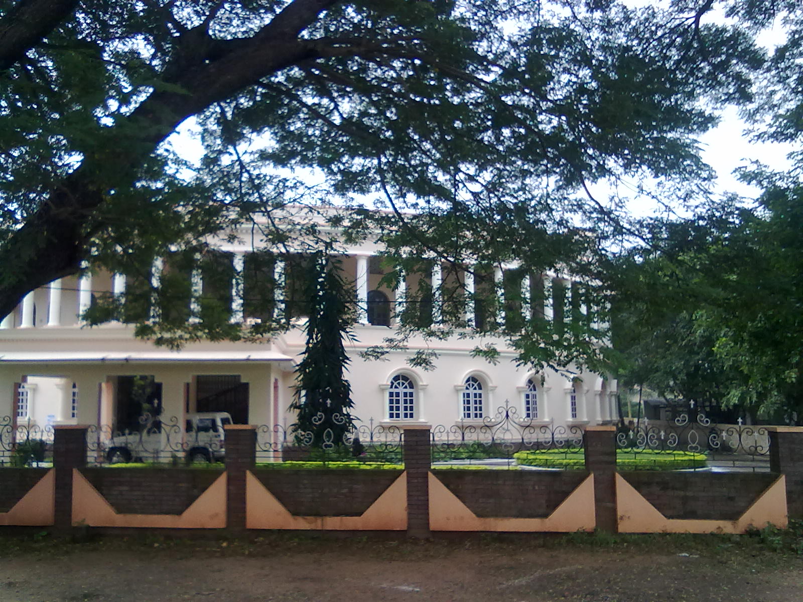
[[File:Not a parliament.jpg|thumb|Government Office in Amalapuram]] | [[File:Not a parliament.jpg|thumb|Government Office in Amalapuram]] | ||
[[File:Sheikh Abdulla Bin Hussein Al Ahmar in New Dehli, India, 2001.jpg|thumb|GMC Balayogi(To the left),Former Speaker of Parliament]] | [[File:Sheikh Abdulla Bin Hussein Al Ahmar in New Dehli, India, 2001.jpg|thumb|GMC Balayogi(To the left),Former Speaker of Parliament]] | ||
Amalapuram is one of the 25 Lok Sabha constituencies in Andhra Pradesh. | Amalapuram is one of the 25 [[Lok Sabha]] constituencies in Andhra Pradesh.{{Citation needed|date=June 2022}} | ||
== Transport == | == Transport == | ||
| Line 82: | Line 72: | ||
== Education == | == Education == | ||
The primary and secondary school education is imparted by government, aided and private schools, under the ''School Education Department'' of the state.<ref>{{cite web|title=School Education Department |url=http://rmsaap.nic.in/Notification_TSG_2015.pdf |publisher=School Education Department, Government of Andhra Pradesh |access-date=7 November 2016|url-status=dead |archive-url=https://web.archive.org/web/20151227185018/http://rmsaap.nic.in/Notification_TSG_2015.pdf |archive-date=27 December 2015 }}</ref><ref>{{cite web|title=The Department of School Education – Official AP State Government Portal {{!}} AP State Portal |url=http://www.ap.gov.in/department/organizations/school-education/ |website=www.ap.gov.in |access-date=7 November 2016 |url-status=dead |archive-url=https://web.archive.org/web/20161107155331/http://www.ap.gov.in/department/organizations/school-education/ |archive-date=7 November 2016 }}</ref> The medium of instruction followed by different schools are English | The primary and secondary school education is imparted by government, aided and private schools, under the ''School Education Department'' of the state.<ref>{{cite web|title=School Education Department |url=http://rmsaap.nic.in/Notification_TSG_2015.pdf |publisher=School Education Department, Government of Andhra Pradesh |access-date=7 November 2016|url-status=dead |archive-url=https://web.archive.org/web/20151227185018/http://rmsaap.nic.in/Notification_TSG_2015.pdf |archive-date=27 December 2015 }}</ref><ref>{{cite web|title=The Department of School Education – Official AP State Government Portal {{!}} AP State Portal |url=http://www.ap.gov.in/department/organizations/school-education/ |website=www.ap.gov.in |access-date=7 November 2016 |url-status=dead |archive-url=https://web.archive.org/web/20161107155331/http://www.ap.gov.in/department/organizations/school-education/ |archive-date=7 November 2016 }}</ref> The medium of instruction followed by different schools are English and Telugu.{{Citation needed|date=June 2022}} | ||
== Notable | == Notable people == | ||
* [[Bayya Suryanarayana Murthy]], former MP of [[Rajya Sabha]], journalist, essayist, short-story writer | |||
* [[Bayya Suryanarayana Murthy]] | * [[G. M. C. Balayogi]], former [[Speaker of the Lok Sabha|Lok Sabha Speaker]] | ||
* [[G. M. C. Balayogi]] | * [[Kala Venkata Rao]], former Minister | ||
* [[Kala Venkata Rao]] | * [[Devi Sri Prasad]], [[Cinema of Andhra Pradesh|Tollywood]] music composer and singer | ||
* [[Devi Sri Prasad]] | * [[Ram Madhav]], General Secretary, [[Bharatiya Janata Party]] | ||
* [[Ram Madhav]] | * [[Satwiksairaj Rankireddy]], badminton player | ||
== References == | == References == | ||
| Line 96: | Line 86: | ||
== External links == | == External links == | ||
* {{Commons category-inline}} | |||
{{Municipalities of Andhra Pradesh}} | {{Municipalities of Andhra Pradesh}} | ||
{{ | {{Dr. B.R. Ambedkar Konaseema district}} | ||
[[Category: | [[Category:Cities and towns in Konaseema district]] | ||
[[Category:Mandal headquarters in | [[Category:Mandal headquarters in Konaseema district]] | ||
Revision as of 22:01, 29 June 2022
Amalapuram | |
|---|---|
 Poornakumbham sculpture in Amalapauram | |
  Amalapuram Location in Andhra Pradesh, India  Amalapuram Amalapuram (India) | |
| Coordinates: 16°34′43″N 82°00′22″E / 16.5787°N 82.0061°E | |
| Country |  India India |
| State | Andhra Pradesh |
| District | Konaseema district |
| Government | |
| • Type | Municipality |
| • Body | Amalapuram Municipal Council |
| • MLA | Pinipe Viswarup |
| Area | |
| • Total | 7.20 km2 (2.78 sq mi) |
| Elevation | 3 m (10 ft) |
| Population (2011)[3] | |
| • Total | 53,231 |
| • Density | 7,400/km2 (19,000/sq mi) |
| Languages | |
| • Official | Telugu |
| Time zone | UTC+5:30 (IST) |
| PIN | 533201 |
| Telephone code | 08856 |
| Vehicle Registration | AP05 (Former) AP39 (from 30 January 2019)[4] |
Amalapuram is a town in the Indian state of Andhra Pradesh. It is the district headquarters and the largest town of Konaseema district. It is the mandal and divisional headquarters of Amalapuram mandal and Amalapuram revenue division respectively.[3][5] The town is situated in the delta of konaseema.[6]
History


Amalapuram was originally named Amlipuri. Some of its temples are dedicated to Amaleswarudu.[citation needed]
Amalapuram is also called Panchalingapuram as it is the seat of five temples to Shiva as Amaleswarudu, Sidheswarudu, Ramalingeswarudu, Chandramouleeswarudu and Chennamalleeswarudu. Amalapuram is the most developed town in Dr. B.R. Ambedkar Konaseema district. It is hub of the district for education and financial institutes. There are approximately 65 schools and colleges, six engineering colleges and one medical college in the area. It is one among few parliament constituencies in India which do not have a railway connectivity.[citation needed]
Geography
Amalapuram is spread over an area of 7.20 km2 (2.78 sq mi).[3] It is located at 16°34′43″N 82°00′22″E / 16.5787°N 82.0061°E. It has an average elevation of 2 m (6 ft 7 in).[citation needed] It is the largest town of Konaseema district.[7]
Demographics
As of 2011[update] India census, Amalapuram has a population of 50,889 with 25,538 males and 25,351 females. Amalapuram has an average literacy rate of 77%, higher than the national average of 59.5%; 80.68% of males and 73.54% of females are literate. 77,036 people reside in rural parts of Amalapuram while 64,158 people reside in the Amalapuram urban area.[8]
Governance
Politics


Amalapuram is one of the 25 Lok Sabha constituencies in Andhra Pradesh.[citation needed]
Transport

The Andhra Pradesh State Road Transport Corporation operates bus services from Amalapuram bus station. Regular buses between Rajahmundry, Kakinada non-stop, hourly based Vizag and Vijayawada from evening buses to Hyderabad available.[9]
Education
The primary and secondary school education is imparted by government, aided and private schools, under the School Education Department of the state.[10][11] The medium of instruction followed by different schools are English and Telugu.[citation needed]
Notable people
- Bayya Suryanarayana Murthy, former MP of Rajya Sabha, journalist, essayist, short-story writer
- G. M. C. Balayogi, former Lok Sabha Speaker
- Kala Venkata Rao, former Minister
- Devi Sri Prasad, Tollywood music composer and singer
- Ram Madhav, General Secretary, Bharatiya Janata Party
- Satwiksairaj Rankireddy, badminton player
References
- ↑ "Municipalities, Municipal Corporations & UDAs" (PDF). Directorate of Town and Country Planning. Government of Andhra Pradesh. Archived from the original (PDF) on 28 January 2016. Retrieved 28 January 2016.
- ↑ "Maps, Weather, and Airports for Amalapuram, India". www.fallingrain.com. Retrieved 4 April 2017.
- ↑ 3.0 3.1 3.2 "District Census Handbook – East Godavari" (PDF). Census of India. pp. 16, 54. Retrieved 4 April 2017.
- ↑ "New 'AP 39' code to register vehicles in Andhra Pradesh launched". The New Indian Express. Vijayawada. 31 January 2019. Retrieved 9 June 2019.
- ↑ "Amalapuram". eastgodavari.nic.in. Archived from the original on 4 April 2017. Retrieved 4 April 2017.
- ↑ Bhaskar, B.V.S. "Water crisis grips DR.B R Ambedkar Konaseema". The Hindu. Retrieved 4 April 2017.
- ↑ Bhattacharjee, Sumit (29 May 2022). "Caste matters in Konaseema". The Hindu. ISSN 0971-751X. Retrieved 3 June 2022.
- ↑ "Census of India 2001: Data from the 2001 Census, including cities, villages and towns (Provisional)". Census Commission of India. Archived from the original on 16 June 2004. Retrieved 1 November 2008.
- ↑ "Bus in Districts". Andhra Pradesh State Road Transport Corporation. Archived from the original on 22 March 2016. Retrieved 9 March 2016.
- ↑ "School Education Department" (PDF). School Education Department, Government of Andhra Pradesh. Archived from the original (PDF) on 27 December 2015. Retrieved 7 November 2016.
- ↑ "The Department of School Education – Official AP State Government Portal | AP State Portal". www.ap.gov.in. Archived from the original on 7 November 2016. Retrieved 7 November 2016.
External links
| District headquarters |  | |
|---|---|---|
| Revenue divisions | ||
| Mandals | ||
| Mandal headquarters | ||
| Cities and towns | ||
| See also | ||
| Templates of other districts | ||