

Kamal Guha (talk | contribs) Andhra Pradesh Buddhist sites template added |
Pankajglobal (talk | contribs) m cleanup |
||
| Line 2: | Line 2: | ||
{{Use Indian English|date=September 2018}} | {{Use Indian English|date=September 2018}} | ||
{{Infobox settlement | {{Infobox settlement | ||
| name | | name = Jaggayyapeta | ||
| other_name = | |||
| nickname = Dongala bethavolu | |||
| other_name | | settlement_type = [[Town]] | ||
| nickname | | image_skyline = View of Jaggayyapeta town from the Buddhist stupa site.jpg | ||
| settlement_type | | image_alt = | ||
| image_skyline | | image_caption = Jaggayyapeta town from the Buddhist stupa site | ||
| image_alt | | pushpin_map = India#India Andhra Pradesh | ||
| image_caption | | pushpin_relief = yes | ||
| pushpin_map | | pushpin_map_alt = | ||
| pushpin_relief | | pushpin_map_caption = Location in Andhra Pradesh, India | ||
| pushpin_map_alt | | coordinates = {{coord|16.8920|N|80.0976|E|display=inline,title}} | ||
| pushpin_map_caption | | subdivision_type = Country | ||
| coordinates | | subdivision_name = {{flag|India}} | ||
| subdivision_type | | subdivision_type1 = [[States and union territories of India|State]] | ||
| subdivision_name | | subdivision_name1 = [[Andhra Pradesh]] | ||
| subdivision_type1 | | subdivision_type2 = [[List of regions of India|Region]] | ||
| subdivision_name1 | | subdivision_name2 = [[Coastal Andhra]] | ||
| subdivision_type2 | | subdivision_type3 = [[List of districts of India|District]] | ||
| subdivision_name2 | | subdivision_name3 = [[NTR District|NTR]] | ||
| subdivision_type3 | | established_title = <!-- Established --> | ||
| subdivision_name3 | | established_date = | ||
| established_title | | founder = | ||
| established_date | | named_for = | ||
| founder | | government_type = | ||
| named_for | | governing_body = Jaggayyapet Municipality | ||
| government_type | | leader_title1 = Member of Legislative Assembly | ||
| governing_body | | leader_name1 = Sriram Rajagopal(Tatayya) | ||
| leader_title1 | | leader_title2 = Member of Parliament | ||
| leader_name1 | | leader_name2 = Kesineni Chinni | ||
| leader_title2 | | unit_pref = Metric | ||
| leader_name2 | | area_footnotes = <ref name=census>{{cite web|title=District Census Handbook - Krishna|url=http://www.censusindia.gov.in/2011census/dchb/2816_PART_B_DCHB_KRISHNA.pdf|website=Census of India|access-date=29 January 2016|page=16,48}}</ref> | ||
| unit_pref | | area_rank = 2nd in district | ||
| area_footnotes | | area_total_km2 = 60 | ||
| area_rank | | elevation_footnotes = <ref>{{cite web|title=Elevation for Jaggayyapet |url=http://veloroutes.org/elevation/?location=Jaggayyapet&units=m|publisher=Veloroutes|access-date=12 August 2014}}</ref> | ||
| area_total_km2 | | elevation_m = 55 | ||
| elevation_footnotes | | population_total = 53530 | ||
| elevation_m | | population_as_of = 2011 | ||
| population_total | | population_rank = | ||
| population_as_of | |||
| population_rank | |||
| population_density_km2 = auto | | population_density_km2 = auto | ||
| population_demonym | | population_demonym = | ||
| population_footnotes | | population_footnotes = <ref name=population>{{cite web|title=Census 2011 |url=http://www.censusindia.gov.in/pca/SearchDetails.aspx?Id=626757|publisher=The Registrar General & Census Commissioner, India|access-date=25 July 2014}}</ref> | ||
| demographics_type1 | | demographics_type1 = Languages | ||
| demographics1_title1 | | demographics1_title1 = Officials | ||
| demographics1_info1 | | demographics1_info1 = [[Telugu language|Telugu]] | ||
| timezone1 | | timezone1 = [[Indian Standard Time|IST]] | ||
| utc_offset1 | | utc_offset1 = +5:30 | ||
| postal_code_type | | postal_code_type = [[Postal Index Number|PIN]] | ||
| postal_code | | postal_code = 521 175 | ||
| area_code_type | | area_code_type = [[Telephone numbers in India|Telephone code]] | ||
| area_code | | area_code = +91–8654 | ||
| registration_plate | | registration_plate = AP–16, AP-39, AP-40 | ||
| blank1_name_sec1 | | blank1_name_sec1 = [[Lok Sabha]] constituency | ||
| blank1_info_sec1 | | blank1_info_sec1 = Vijayawada | ||
| blank2_name_sec1 | | blank2_name_sec1 = [[Vidhan Sabha]] constituency | ||
| blank2_info_sec1 | | blank2_info_sec1 = Jaggayyapet | ||
| website | | website = | ||
| footnotes | | footnotes = | ||
}}'''Jaggayyapeta,''' also spelled | | mapframe = yes | ||
| mapframe-zoom = 13 | |||
| mapframe-wikidata = yes | |||
| map_caption = Interactive map | |||
}} | |||
'''Jaggayyapeta,''' also spelled “Jaggaiahpet”, is a [[census town]] in [[NTR district]] of the [[India]]n state of [[Andhra Pradesh]], located just southwest of the border with [[Telangana]]. It is also the [[mandal]] headquarters of [[Jaggayyapeta mandal]] of [[Nandigama revenue division]].<ref name=map>{{cite web|title=Krishna District Mandals|url=http://www.censusindia.gov.in/2011census/maps/atlas/28part31.pdf |publisher=Census of India|access-date=21 January 2015|pages=474, 523}}</ref><ref>{{cite web|title=Administrative Setup|url=http://krishna.nic.in/admin-setup.aspx|website=Krishna District Official Website|publisher=National Informatics Centre|access-date=9 February 2015|archive-url=https://web.archive.org/web/20141020223104/http://krishna.nic.in/admin-setup.aspx|archive-date=20 October 2014|url-status=dead}}</ref> Jaggayyapet is the second biggest town in the district followed by Vijayawada.The town is located on the banks of the [[Paleru|Paleru River]] which is a tributary of the [[Krishna River]]. | |||
== Etymology == | == Etymology == | ||
| Line 71: | Line 75: | ||
Government records suggest the founder of the town was Venkatadri Nayudu, who developed and renamed the village of Betavolu to Jaggayyapeta. The region was then infested with robbers and hence the old village was called Dongala Betavolu (Robbers' Betavolu). For some time, Jaggayyapeta was mentioned in Government records with Betavolu written in brackets. This region has an ancient history, the innocent-looking mound 'Dhanam Bodu', lying east of Jaggayyapeta, has in it the remains of an ancient [[stupa]], which has been lying there for 2,000 years. Jaggayyapeta became a municipality in 1987 and Sreeram Badari Narayanarao was elected as 1st municipal chairman. | Government records suggest the founder of the town was Venkatadri Nayudu, who developed and renamed the village of Betavolu to Jaggayyapeta. The region was then infested with robbers and hence the old village was called Dongala Betavolu (Robbers' Betavolu). For some time, Jaggayyapeta was mentioned in Government records with Betavolu written in brackets. This region has an ancient history, the innocent-looking mound 'Dhanam Bodu', lying east of Jaggayyapeta, has in it the remains of an ancient [[stupa]], which has been lying there for 2,000 years. Jaggayyapeta became a municipality in 1987 and Sreeram Badari Narayanarao was elected as 1st municipal chairman. | ||
===Artifacts=== | ===Artifacts=== | ||
The archaeological excavations around the town of Jaggayyapeta have found Buddhist stupas dating back to 200 BC.<ref>{{cite journal|last1=Mackenzie|first1=Gordon|title=Sablt Ob Hindu | The [[Archaeological excavation|archaeological excavations]] around the town of Jaggayyapeta have found [[Buddhist stupa|Buddhist stupas]] dating back to 200 BC.<ref>{{cite journal|last1=Mackenzie|first1=Gordon|title=Sablt Ob Hindu Period|journal=A_Manual_of_the_Kistna_District_in_the_Presidency_of_Madras_1000731755/9|volume=2013|pages=9–10|url=http://www.forgottenbooks.com/readbook_text/A_Manual_of_the_Kistna_District_in_the_Presidency_of_Madras_1000731755/9|access-date=7 February 2016|publisher=Forgotten Books}}</ref><ref>{{cite web|title=List of Departmental Explorations 1970 - 2002|url=http://aparchmuseums.nic.in/explorationsexcavations.html|website=Department of Archaeology & Museums|access-date=7 February 2016}}</ref> Sculptures and scriptures of [[Neolithic]], [[Megalithic]] and [[medieval period]]s are also found around the town.<ref>{{cite web|title=Indian Archaeology 1984-85, A Review|url=http://asi.nic.in/nmma_reviews/Indian%20Archaeology%201984-85%20A%20Review.pdf|publisher=Archaeological Survey of India|access-date=7 February 2016|pages=4–5}}</ref> | ||
<gallery> | <gallery> | ||
| Line 91: | Line 93: | ||
==Economy== | ==Economy== | ||
The town’s [[mango]] orchards are abundant with Banginapalli and Totapuri varieties, which are even exported to foreign countries.<ref>{{cite news |last1=Srinivas|first1=Rajulapudi|title=Bumper harvest of mangoes likely|url=http://www.thehindu.com/news/cities/Vijayawada/bumper-harvest-of-mangoes-likely/article4669782.ece|access-date=17 July 2015|work=The Hindu|date=30 April 2013 |location=Nuzvid (Krishna District)}}</ref><ref>{{cite news|author1=B. MADHU GOPAL |title=Mangoes up for grabs |url=http://www.thehindu.com/thehindu/mp/2003/05/26/stories/2003052601130100.htm|archive-url=https://web.archive.org/web/20030611022952/http://thehindu.com/thehindu/mp/2003/05/26/stories/2003052601130100.htm|url-status=dead|archive-date=11 June 2003|access-date=17 July 2015|work=[[The Hindu]] |date=26 May 2003}}</ref> It is one of the major industrial corridors in the Krishna district. The region’s cement plants are located in and around Jaggayyapeta. | The town’s [[mango]] [[orchards]] are abundant with [[Banginapalli]] and [[Totapuri (mango)|Totapuri]] varieties, which are even exported to foreign countries.<ref>{{cite news |last1=Srinivas|first1=Rajulapudi|title=Bumper harvest of mangoes likely|url=http://www.thehindu.com/news/cities/Vijayawada/bumper-harvest-of-mangoes-likely/article4669782.ece|access-date=17 July 2015|work=The Hindu|date=30 April 2013 |location=Nuzvid (Krishna District)}}</ref><ref>{{cite news|author1=B. MADHU GOPAL |title=Mangoes up for grabs |url=http://www.thehindu.com/thehindu/mp/2003/05/26/stories/2003052601130100.htm|archive-url=https://web.archive.org/web/20030611022952/http://thehindu.com/thehindu/mp/2003/05/26/stories/2003052601130100.htm|url-status=dead|archive-date=11 June 2003|access-date=17 July 2015|work=[[The Hindu]] |date=26 May 2003}}</ref> It is one of the major industrial corridors in the Krishna district. The region’s cement plants are located in and around Jaggayyapeta. It has more than 10 cements plants around and there are more than 100 gold merchants in the town. | ||
== Transport == | == Transport == | ||
Jaggayyapeta is located near to [[National Highway 65 (India | Jaggayyapeta is located near to [[National Highway 65 (India, old numbering)|NH 65]], which connects [[Pune]] and [[Machilipatnam]]. The [[Andhra Pradesh State Road Transport Corporation]] operates buses from Jaggayyapeta bus station which also has a [[Bus garage|bus depot]].<ref>{{cite web|title=Bus Stations in Districts |url=http://www.apsrtc.gov.in/Bus%20Stations.aspx |website=Andhra Pradesh State Road Transport Corporation |access-date=8 March 2016 |url-status=dead |archive-url=https://web.archive.org/web/20160322233330/http://apsrtc.gov.in/Bus%20Stations.aspx |archive-date=22 March 2016 }}</ref><ref>{{cite news|last1=Sujatha Varma|first1=P|title=RTC offers a 'sweet' journey|url=http://www.thehindu.com/news/cities/Vijayawada/rtc-offers-a-sweet-journey/article8204492.ece|access-date=8 March 2016|work=The Hindu|date=7 February 2016|location=Vijayawada}}</ref> The town has a total road length of {{Convert|109.00|km|mi|abbr=on}}.<ref>{{cite web|title=Details of Roads in Each ULB of Andhra Pradesh |url=http://centralapp.cdma.ap.gov.in:8080/CDMAAPTaxesInfo/RoadDetails.jsp |website=Commissioner and Directorate of Municipal Administration |publisher=Municipal Administration and Urban Development Department - Government of Andhra Pradesh |access-date=28 March 2017 |url-status=dead |archive-url=https://web.archive.org/web/20160801101300/http://centralapp.cdma.ap.gov.in:8080/CDMAAPTaxesInfo/RoadDetails.jsp |archive-date= 1 August 2016 }}</ref> | ||
==Education== | ==Education== | ||
| Line 105: | Line 107: | ||
==References== | ==References== | ||
{{Reflist}} | {{Reflist}} | ||
{{NTR district}} | {{NTR district}} | ||
Latest revision as of 05:51, 2 November 2025
Jaggayyapeta | |
|---|---|
 Jaggayyapeta town from the Buddhist stupa site | |
| Nickname: Dongala bethavolu | |
  Jaggayyapeta Location in Andhra Pradesh, India  Jaggayyapeta Jaggayyapeta (Andhra Pradesh) | |
| Coordinates: 16°53′31″N 80°05′51″E / 16.8920°N 80.0976°E | |
| Country |  India India |
| State | Andhra Pradesh |
| Region | Coastal Andhra |
| District | NTR |
| Government | |
| • Body | Jaggayyapet Municipality |
| • Member of Legislative Assembly | Sriram Rajagopal(Tatayya) |
| • Member of Parliament | Kesineni Chinni |
| Area | |
| • Total | 60 km2 (20 sq mi) |
| • Rank | 2nd in district |
| Elevation | 55 m (180 ft) |
| Population (2011)[3] | |
| • Total | 53,530 |
| • Density | 890/km2 (2,300/sq mi) |
| Languages | |
| • Officials | Telugu |
| Time zone | UTC+5:30 (IST) |
| PIN | 521 175 |
| Telephone code | +91–8654 |
| Vehicle registration | AP–16, AP-39, AP-40 |
| Lok Sabha constituency | Vijayawada |
| Vidhan Sabha constituency | Jaggayyapet |
Jaggayyapeta, also spelled “Jaggaiahpet”, is a census town in NTR district of the Indian state of Andhra Pradesh, located just southwest of the border with Telangana. It is also the mandal headquarters of Jaggayyapeta mandal of Nandigama revenue division.[4][5] Jaggayyapet is the second biggest town in the district followed by Vijayawada.The town is located on the banks of the Paleru River which is a tributary of the Krishna River.
Etymology[edit | edit source]
Jaggaiahpeta was governed by a ruler, by name Sri Rajah Vasireddy Venkatadri Nayudu. It is said that he founded two towns, namely, Jaggayyapeta, named after his father Jaggayya, and Achampeta, named after his mother Atchamma.
History[edit | edit source]
 |
Government records suggest the founder of the town was Venkatadri Nayudu, who developed and renamed the village of Betavolu to Jaggayyapeta. The region was then infested with robbers and hence the old village was called Dongala Betavolu (Robbers' Betavolu). For some time, Jaggayyapeta was mentioned in Government records with Betavolu written in brackets. This region has an ancient history, the innocent-looking mound 'Dhanam Bodu', lying east of Jaggayyapeta, has in it the remains of an ancient stupa, which has been lying there for 2,000 years. Jaggayyapeta became a municipality in 1987 and Sreeram Badari Narayanarao was elected as 1st municipal chairman.
Artifacts[edit | edit source]
The archaeological excavations around the town of Jaggayyapeta have found Buddhist stupas dating back to 200 BC.[6][7] Sculptures and scriptures of Neolithic, Megalithic and medieval periods are also found around the town.[8]
-
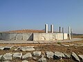 A View of Jaggayyapeta Buddhist stupa, with remains of reliefs.
 -
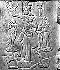 Chakravartin from Jaggayyapeta Stupa
 -
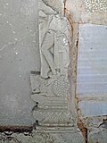 Sculpted frieze ruins on Jaggayyapeta Buddhist stupa
 -
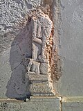 Sculpted relief on Jaggayyapeta Buddhist stupa.


Governance[edit | edit source]
Civic administration
The municipality of Jaggayyapeta was formed in the year 1988. It is a II–Grade Municipality with 32 wards spread over an area of 23.50 km2 (9.07 sq mi).[1]
Economy[edit | edit source]
The town’s mango orchards are abundant with Banginapalli and Totapuri varieties, which are even exported to foreign countries.[9][10] It is one of the major industrial corridors in the Krishna district. The region’s cement plants are located in and around Jaggayyapeta. It has more than 10 cements plants around and there are more than 100 gold merchants in the town.
Transport[edit | edit source]
Jaggayyapeta is located near to NH 65, which connects Pune and Machilipatnam. The Andhra Pradesh State Road Transport Corporation operates buses from Jaggayyapeta bus station which also has a bus depot.[11][12] The town has a total road length of 109.00 km (67.73 mi).[13]
Education[edit | edit source]
The primary and secondary school education is imparted by government, aided and private schools, under the School Education Department of the state.[14][15] The medium of instruction followed by different schools are English and Telugu.
See also[edit | edit source]
References[edit | edit source]
- ↑ 1.0 1.1 "District Census Handbook - Krishna" (PDF). Census of India. p. 16,48. Retrieved 29 January 2016.
- ↑ "Elevation for Jaggayyapet". Veloroutes. Retrieved 12 August 2014.
- ↑ "Census 2011". The Registrar General & Census Commissioner, India. Retrieved 25 July 2014.
- ↑ "Krishna District Mandals" (PDF). Census of India. pp. 474, 523. Retrieved 21 January 2015.
- ↑ "Administrative Setup". Krishna District Official Website. National Informatics Centre. Archived from the original on 20 October 2014. Retrieved 9 February 2015.
- ↑ Mackenzie, Gordon. "Sablt Ob Hindu Period". A_Manual_of_the_Kistna_District_in_the_Presidency_of_Madras_1000731755/9. 2013. Forgotten Books: 9–10. Retrieved 7 February 2016.
- ↑ "List of Departmental Explorations 1970 - 2002". Department of Archaeology & Museums. Retrieved 7 February 2016.
- ↑ "Indian Archaeology 1984-85, A Review" (PDF). Archaeological Survey of India. pp. 4–5. Retrieved 7 February 2016.
- ↑ Srinivas, Rajulapudi (30 April 2013). "Bumper harvest of mangoes likely". The Hindu. Nuzvid (Krishna District). Retrieved 17 July 2015.
- ↑ B. MADHU GOPAL (26 May 2003). "Mangoes up for grabs". The Hindu. Archived from the original on 11 June 2003. Retrieved 17 July 2015.
- ↑ "Bus Stations in Districts". Andhra Pradesh State Road Transport Corporation. Archived from the original on 22 March 2016. Retrieved 8 March 2016.
- ↑ Sujatha Varma, P (7 February 2016). "RTC offers a 'sweet' journey". The Hindu. Vijayawada. Retrieved 8 March 2016.
- ↑ "Details of Roads in Each ULB of Andhra Pradesh". Commissioner and Directorate of Municipal Administration. Municipal Administration and Urban Development Department - Government of Andhra Pradesh. Archived from the original on 1 August 2016. Retrieved 28 March 2017.
- ↑ "School Education Department" (PDF). School Education Department, Government of Andhra Pradesh. Archived from the original (PDF) on 27 December 2015. Retrieved 7 November 2016.
- ↑ "The Department of School Education - Official AP State Government Portal | AP State Portal". www.ap.gov.in. Archived from the original on 7 November 2016. Retrieved 7 November 2016.