CleanupBot (talk | contribs) m →top: clean up |
m added intro and improved wording for clarity |
||
| Line 2: | Line 2: | ||
{{Use Indian English|date=June 2018}} | {{Use Indian English|date=June 2018}} | ||
{{Infobox settlement | {{Infobox settlement | ||
| name | | name = | ||
| | | native_name = {{lang|te-Latn|Āndhra Pradēś Rājadhāni Prāntaṁ}} | ||
| image_skyline | | native_name_lang = <!-- ISO 639-1 code e.g. "fr" for French. If more than one, use {{lang}} instead --> | ||
| imagesize | | settlement_type = [[Capital Region]] | ||
| image_caption | | image_skyline = Andhra Pradesh Capital Region.jpg | ||
| image_map | | imagesize = 250 | ||
| | | image_alt = Andhra Pradesh Capital Region.jpg | ||
| map_caption | | image_caption = Zonal map of Andhra Pradesh Capital Region with the city of [[Amaravati]] on the banks of [[River Krishna]] | ||
| subdivision_name | | image_flag = | ||
| | | flag_alt = | ||
| | | image_seal = | ||
| | | seal_size = | ||
| | | seal_alt = | ||
| | | image_shield = | ||
| | | shield_alt = | ||
| | | etymology = | ||
| | | nickname = | ||
| | | motto = | ||
| image_map = | |||
| website | | map_alt = | ||
| | | map_caption = | ||
| pushpin_map = | |||
| pushpin_map_alt = | |||
| pushpin_map_caption = | |||
| pushpin_label_position = | |||
| coordinates = <!-- {{coord|latitude|longitude|type:city|display=inline,title}} --> | |||
| coor_pinpoint = | |||
| coordinates_footnotes = | |||
| subdivision_type = Country | |||
| subdivision_name = {{flag|India}} | |||
| subdivision_type1 = [[States and union territories of India|State]] | |||
| subdivision_name1 = {{Flag icon image| Emblem of Andhra Pradesh.svg}} [[Andhra Pradesh]] | |||
| subdivision_type3 = [[List of districts of India|Districts]] | |||
| subdivision_name3 = {{bulleted list| | |||
[[Krishna district|Krishna]]|[[Guntur district|Guntur]]|[[NTR district|NTR]]|[[Palnadu district|Palnadu]]|[[Bapatla district|Bapatla]]|[[Eluru district|Eluru]]}} | |||
| established_title = Created | |||
| established_date = 2014 | |||
| founder = [[Government of Andhra Pradesh]] | |||
| seat_type = Major Cities and Towns | |||
| seat = {{bulleted list| | |||
[[Vijayawada]]|[[Amaravati]]|[[Guntur]]|[[Tenali]]}} | |||
| government_footnotes = | |||
| government_type = | |||
| governing_body = | |||
| leader_party = | |||
| leader_title = | |||
| leader_name = | |||
| leader_title1 = | |||
| leader_name1 = | |||
| leader_title2 = | |||
| leader_name2 = | |||
| leader_title3 = | |||
| leader_name3 = | |||
| leader_title4 = | |||
| leader_name4 = | |||
| unit_pref = Metric | |||
<!-- ALL fields with measurements have automatic unit conversion --> | |||
<!-- for references: use <ref> tags -->| area_footnotes = | |||
| area_urban_footnotes = <!-- <ref> </ref> --> | |||
| area_rural_footnotes = <!-- <ref> </ref> --> | |||
| area_metro_footnotes = <!-- <ref> </ref> --> | |||
| area_note = | |||
| area_water_percent = | |||
| area_rank = | |||
| area_blank1_title = | |||
| area_blank2_title = <!-- square kilometers --> | |||
| area_total_km2 = 8654.05 | |||
| area_land_km2 = | |||
| area_water_km2 = | |||
| area_urban_km2 = | |||
| area_rural_km2 = | |||
| area_metro_km2 = | |||
| area_blank1_km2 = | |||
| area_blank2_km2 = <!-- hectares --> | |||
| area_total_ha = | |||
| area_land_ha = | |||
| area_water_ha = | |||
| area_urban_ha = | |||
| area_rural_ha = | |||
| area_metro_ha = | |||
| area_blank1_ha = | |||
| area_blank2_ha = | |||
| length_km = | |||
| width_km = | |||
| dimensions_footnotes = | |||
| elevation_footnotes = | |||
| elevation_m = | |||
| population_footnotes = <ref name="population">{{cite web|title=Demography|url=http://www.crda.ap.gov.in/APCRDADOCS/DataModuleFIles/Demography/01~12112011%20census%20capital%20region.xlsx|website=APCRDA|publisher=Government of Andhra Pradesh|access-date=30 June 2016|format=PDF|archive-date=13 September 2016|archive-url=https://web.archive.org/web/20160913123557/http://www.crda.ap.gov.in/APCRDADOCS/DataModuleFIles/Demography/01~12112011%20census%20capital%20region.xlsx|url-status=dead}}</ref> | |||
| population_as_of = 2011 | |||
| population_total = 5873588 | |||
| population_density_km2 = auto | |||
| population_note = | |||
| population_demonym = | |||
| timezone1 = [[Indian Standard Time]] | |||
| utc_offset1 = +5:30 | |||
| timezone1_DST = | |||
| utc_offset1_DST = | |||
| postal_code_type = [[Postal Index Number|PIN Code]] | |||
| postal_code = | |||
| area_code_type = | |||
| area_code = | |||
| area_codes = <!-- for multiple area codes --> | |||
| iso_code = | |||
| blank_name_sec1 = [[Nominal GDP]](2022-23) | |||
| blank_info_sec1 = {{INRConvert|188502|c|year=2022|mode=historical}}<ref>{{cite web | title=Metropolitan Region Statistics | url=https://crda.ap.gov.in/apcrdav2/views/DynamicHorizontalTabNew.aspx?CapitalType=1 }}</ref> | |||
| blank1_name_sec1 = GDP Contribution to state | |||
| blank1_info_sec1 = 14.5% | |||
| website = {{URL|http://crda.ap.gov.in/APCRDA/UserInterface/Loginform.aspx|APCRDA}} | |||
| module = | |||
| footnotes = | |||
| subdivision_type4 = [[Headquarters]] | |||
| subdivision_name4 = [[Amaravati]] | |||
}} | }} | ||
'''Andhra Pradesh Capital Region''' is the [[metropolitan | '''Andhra Pradesh Capital Region''' ([[ISO 15919|ISO]]: Āndhra Pradēś Rājadhāni Prāntaṁ) is the [[metropolitan area]] of the [[capital city]] of [[Andhra Pradesh]] in [[India]]. The region is spread across the districts of [[Krishna district|Krishna]], [[Guntur district|Guntur]], [[Palnadu district|Palnadu]], [[NTR district|NTR]], [[Bapatla district|Bapatla]] and [[Eluru district|Eluru]]. It includes the major cities of [[Vijayawada]] and [[Guntur]]. Vijayawada is the largest city and headquarters of the region. It is one the most populated metropolitan areas in Andhra Pradesh.<ref>{{Cite web|url=https://www.deccanchronicle.com/nation/current-affairs/190816/vijayawada-is-third-densely-packed-city-31200-people-in-every-square-km.html|title=Vijayawada is third densely packed city; 31,200 people in every square km|first=u sudhakar|last=reddy|date=19 August 2016|website=Deccan Chronicle}}</ref> The region is under the jurisdiction of [[Andhra Pradesh Capital Region Development Authority]] and covers an area of {{convert|8603|sqkm|abbr=on}} under 58 [[mandal]]s.<ref name="crda">{{cite web|title=A.P. Capital Region|url=http://www.crda.ap.gov.in/APCRDADOCS/DataModuleFIles/FACTS%20AND%20FIGURES%20OF%20CAPITAL%20REGION/01~1117CRDA%20Factfile%20(%20Web%20view).pdf|website=APCRDA|publisher=Government of Andhra Pradesh|access-date=1 September 2016|page=15|archive-url=https://web.archive.org/web/20160913124145/http://www.crda.ap.gov.in/APCRDADOCS/DataModuleFIles/FACTS%20AND%20FIGURES%20OF%20CAPITAL%20REGION/01~1117CRDA%20Factfile%20(%20Web%20view).pdf |archive-date=13 September 2016}}</ref> The capital city [[Amaravati]] is an urban notified area and will cover {{Convert|217.23|km2|mi2|abbr=on}}, within the Andhra Pradesh Capital Region.<ref>{{cite news|last1=Mahalakshmi|first1=BV|title=Foundation stone of Andhra Pradesh's new capital Amaravati laid by PM Narendra Modi|url=http://www.financialexpress.com/article/economy/pm-narendra-modi-lays-foundation-stone-for-andhra-pradeshs-new-capital-amaravati/155133/|access-date=5 June 2016|work=The Financial Express|date=22 October 2015|archive-url=https://web.archive.org/web/20160701074811/http://www.financialexpress.com/article/economy/pm-narendra-modi-lays-foundation-stone-for-andhra-pradeshs-new-capital-amaravati/155133/|archive-date=1 July 2016|url-status=dead|df=dmy-all}}</ref> | ||
== | == Background == | ||
{{Further|Amaravati|Andhra Pradesh Capital Region Development Authority}} | |||
== | After the bifurcation of [[United Andhra Pradesh]], the newly formed [[Government of Andhra Pradesh]] constituted the Andhra Pradesh Capital Region Development Authority in 2014 and the Andhra Pradesh Capital Region was formed with a extent of {{Convert|7319|km2|mi2|abbr=on}}. The limits of the region was expanded on 22 September 2015, which resulted in addition and removal of the mandals and villages taking the total area to {{Convert|8603|km2|mi2|abbr=on}}.<ref name="mandals" /><ref name="newmandals">{{cite web|url=http://www.crda.ap.gov.in/APCRDADOCS/GOSACTSRULES/CRDA/01~14182015MAUD_MS207.PDF |title=Declaration of A.P. Capital Region |date=22 September 2015 |website=APCRDA |publisher=Municipal Administration and Urban Development Department |access-date=21 February 2016 |url-status=dead|archive-url=https://web.archive.org/web/20160221091124/http://www.crda.ap.gov.in/APCRDADOCS/GOSACTSRULES/CRDA/01~14182015MAUD_MS207.PDF |archive-date=21 February 2016 }}</ref><ref>{{cite news|last1=Subba Rao|first1=GVR|title=Capital region expands as CRDA redraws boundaries|url=http://www.thehindu.com/news/cities/Vijayawada/capital-region-expands-as-crda-redraws-boundaries/article7680051.ece|access-date=31 October 2015|work=The Hindu|date=23 September 2015|location=Vijayawada}}</ref> As of 1 August 2020, government of Andhra Pradesh proposed three capitals, which are [[Visakhapatnam]] as the executive capital, [[Amaravati]] as the legislative capital, and [[Kurnool]] as the judicial capital, but the process was cancelled and reverted back to the original 2014 plan of a singular capital city at Amaravati on 22 November 2021.<ref>{{cite web |date=21 September 2020 |title=High court extends status quo on three capitals |url=https://www.tribuneindia.com/news/nation/andhra-hc-extends-status-quo-on-three-capitals-row-till-october-5-144512 |website=[[The Tribune (India)|The Tribune]]}}</ref> | ||
The | == Administration and Jurisdiction == | ||
The [[Andhra Pradesh Capital Region Development Authority]] is responsible for the administration and governance of the entire region under the Department of Municipal Administration and Urban Development of Andhra Pradesh. | |||
{| class="wikitable" style=" | The region is partially spread across 6 districts and subdivided into 8 zones for administrative purposes.[https://crda.ap.gov.in/APCRDADOCS/DataModuleFIles/Maps/01~1324Zones-ULBs.jpg] It consists of 33 complete and 25 part mandals, totaling 58 mandals with 3 [[Municipal Corporation|municipal corporations]], 10 [[Municipality|municipalities]] and 1006 [[Gram Panchayat|gram panchayats]] spanning across 953 revenue villages.<ref>{{cite web|title=Urban Footprints in APCRDA Region|url=https://crda.ap.gov.in/APCRDADOCS/DataModuleFIles/Maps/01~1332ULB%20footprints.jpg|website=APCRDA|access-date=27 June 2016}}</ref><ref>{{cite news|title=AP Capital Region Development Authority comes into being|url=http://www.thehindu.com/news/cities/Vijayawada/ap-capital-region-development-authority-comes-into-being/article6739396.ece|access-date=6 January 2015|work=The Hindu|date=31 December 2014|location=Hyderabad}}</ref><ref name="mandals">{{cite web|title=District wise mandals and villages covered in Krishna and Guntur districts |url=http://crda.ap.gov.in/APCRDA/Downloads/Notifications/2014MAUD_MS253.PDF |website=Andhra Pradesh Capital Region Development Authority |publisher=Government of Andhra Pradesh |access-date=23 September 2015 |url-status=dead|archive-url=https://web.archive.org/web/20150923135735/http://crda.ap.gov.in/APCRDA/Downloads/Notifications/2014MAUD_MS253.PDF |archive-date=23 September 2015 }}</ref><ref name=CRDA>{{cite web|title= Andhra Pradesh Capital Region Development Authority |url=https://crda.ap.gov.in/APCRDADOCS/DataModuleFIles/FACTS%20AND%20FIGURES%20OF%20CAPITAL%20REGION/01~1117CRDA%20Factfile%20(%20Web%20view).pdf |website=APCRDA |publisher=Government of Andhra Pradesh |access-date=12 April 2023 }}</ref> | ||
{| class="wikitable sortable" style="text-align:center;" | |||
|- | |||
!Zone | |||
!District | |||
!Mandal | |||
|- | |||
!style="background:#FFD700 ; color:black;" |Amaravati | |||
![[Guntur district]] | |||
|[[Thullur mandal]] | |||
|- | |||
!rowspan=5 style="background:#A020F0 ; color:black;" |Western Zone | |||
! rowspan=5 |[[NTR district]] | |||
|[[Kanchikacherla mandal]] | |||
|- | |||
|[[Veerullapadu mandal]] | |||
|- | |||
|[[Nandigama mandal]] (Part) | |||
|- | |||
|[[Chandarlapadu mandal]] (Part) | |||
|- | |||
|[[Penuganchiprolu mandal]] (Part) | |||
|- | |||
!rowspan=6 style="background:#90EE90; color:black;"|South West Zone | |||
!rowspan=6 |[[Palnadu district]] | |||
|[[Amaravati mandal, Andhra Pradesh|Amaravati mandal]] | |||
|- | |||
|[[Pedakurapadu mandal]] | |||
|- | |||
|Krosuru mandal (Part) | |||
|- | |- | ||
|[[Sattenapalle mandal]] (Part) | |||
|- | |- | ||
|[[Atchampet mandal, Palnadu district|Atchampet mandal]] (Part) | |||
|- | |- | ||
| | |Muppalla mandal (part) | ||
|- | |- | ||
| | !rowspan=10 style="background:#FF474C ; color:black;"|Southern Zone | ||
| | ! rowspan=8 |[[Guntur district]] | ||
|[[Pedanandipadu mandal]] (Part) | |||
| | |||
|- | |- | ||
|[[Tadikonda mandal]] | |||
|- | |- | ||
|[[Guntur mandal]] | |||
|- | |- | ||
|[[Medikonduru mandal]] | |||
|- | |- | ||
|[[Pedakakani mandal]] | |||
|- | |- | ||
| | |Vatticherukuru mandal | ||
|- | |- | ||
|[[Prathipadu mandal|Pratipadu mandal]] (Part) | |||
| | |||
|- | |- | ||
| | |Phirangipuram mandal (Part) | ||
|- | |- | ||
!rowspan=2 |[[Palnadu district]] | |||
|[[Edlapadu|Edlapadu mandal]] (Part) | |||
|- | |- | ||
| | |[[Nadendla|Nadendla mandal]] (Part) | ||
| | |||
|- | |- | ||
| | !rowspan=10 style="background:#964B00 ; color:black;"|South East Zone | ||
| | ! rowspan=7 |[[Guntur district]] | ||
| | |[[Duggirala mandal]] | ||
|- | |- | ||
|[[Tenali mandal]] | |||
|- | |- | ||
|[[Chebrolu mandal]] | |||
|- | |- | ||
|[[Bhattiprolu mandal]] | |||
|- | |- | ||
|[[Kollipara mandal]] | |||
|- | |- | ||
| | |Tsunduru mandal | ||
|- | |- | ||
|[[Ponnur mandal]] (Part) | |||
|- | |- | ||
! | !rowspan=3 |[[Bapatla district]] | ||
|[[Vemuru mandal]] | |||
|- | |- | ||
|[[Kollur mandal]] | |||
|- | |- | ||
| | |Amruthaluru mandal | ||
|- | |- | ||
| 2 | !rowspan=6 style="background:#FFA07A ; color:black;"|Central Zone | ||
! rowspan=2 |[[Guntur district]] | |||
|[[ | |[[Tadepalle mandal, Guntur district|Tadepalle mandal]] | ||
|- | |- | ||
| | |[[Mangalagiri mandal]] | ||
|- | |- | ||
!rowspan=6 |[[NTR district]] | |||
|[[Vijayawada Rural mandal]] | |||
| | |||
|- | |- | ||
|[[Vijayawada Urban mandal]] | |||
|- | |- | ||
|[[Ibrahimpatnam mandal]] | |||
|- | |- | ||
|[[Penamaluru mandal]] | |||
|- | |- | ||
| | !rowspan=4 style="background:#AA336A ; color:black;"|Northern Zone | ||
|[[G. Konduru mandal]] | |||
|[[ | |||
|- | |- | ||
|[[Mylavaram mandal]] (Part) | |||
|- | |- | ||
! | !rowspan=2 |[[Eluru district]] | ||
|[[Agiripalli mandal]] | |||
|- | |- | ||
|[[Nuzividu mandal]] (Part) | |||
|- | |- | ||
| | !rowspan=3 style="background:#FF8C00 ; color:black;"|North East Zone | ||
!rowspan=16 |[[Krishna district]] | |||
|[[ | |[[Gannavaram mandal]] | ||
|- | |- | ||
|[[Unguturu mandal, Krishna district|Unguturu mandal]] | |||
| | |||
|- | |- | ||
|[[Bapulapadu mandal]] (Part) | |||
|- | |- | ||
| | !rowspan=13 style="background:#87CEEB ; color:black;"|Eastern Zone | ||
|[[Vuyyuru mandal]] | |||
|- | |- | ||
|[[Kankipadu mandal]] | |||
|- | |- | ||
|[[Pamidimukkala mandal]] | |||
|- | |- | ||
|[[Thotlavalluru mandal]] | |||
|- | |- | ||
|[[Pedaparupudi mandal]] | |||
|- | |- | ||
|[[Gudlavalleru mandal]] (Part) | |||
|- | |- | ||
|[[Nandivada mandal]] (Part) | |||
|- | |- | ||
|[[Mopidevi mandal]] (Part) | |||
|- | |- | ||
|[[Ghantasala mandal]] (Part) | |||
|- | |- | ||
|[[Challapalli mandal]] (Part) | |||
|- | |- | ||
| | |[[Pamarru mandal]] (Part) | ||
|- | |- | ||
| | |[[Gudivada mandal]] (Part) | ||
|- | |- | ||
|[[Movva mandal]] (Part) | |||
|} | |} | ||
== See also == | == See also == | ||
*[[Andhra Pradesh Capital Region Development Authority]] | *[[Andhra Pradesh Capital Region Development Authority]] | ||
*[[List of mandals in Andhra Pradesh]] | |||
== References == | == References == | ||
| Line 266: | Line 279: | ||
{{Amaravati topics}} | {{Amaravati topics}} | ||
{{Portal bar|India}} | |||
{{commons category|Andhra Pradesh Capital Region}} | {{commons category|Andhra Pradesh Capital Region}} | ||
{{Coord|16|30|30|N|80|38|30|E|display=title}} | {{Coord|16|30|30|N|80|38|30|E|display=title}} | ||
[[Category:Andhra Pradesh Capital Region| | [[Category:Andhra Pradesh Capital Region| ]] | ||
[[Category:Geography of Andhra Pradesh]] | |||
[[Category:Metropolitan areas of India]] | [[Category:Metropolitan areas of India]] | ||
[[Category:Geography of Guntur district]] | [[Category:Geography of Guntur district]] | ||
[[Category:Geography of Krishna district]] | [[Category:Geography of Krishna district]] | ||
[[Category:Proposed infrastructure in | [[Category:Proposed infrastructure in Andhra Pradesh]] | ||
Latest revision as of 00:07, 11 January 2026
Andhra Pradesh Capital Region
Āndhra Pradēś Rājadhāni Prāntaṁ | |
|---|---|
 Zonal map of Andhra Pradesh Capital Region with the city of Amaravati on the banks of River Krishna | |
| Country |  India India |
| State | Template:Flag icon image Andhra Pradesh |
| Districts | |
| Headquarters | Amaravati |
| Created | 2014 |
| Founded by | Government of Andhra Pradesh |
| Major Cities and Towns | |
| Area | |
| • Total | 8,654.05 km2 (3,341.35 sq mi) |
| Population (2011)[1] | |
| • Total | 5,873,588 |
| • Density | 680/km2 (1,800/sq mi) |
| Time zone | UTC+5:30 (Indian Standard Time) |
| Nominal GDP(2022-23) | ₹188,502 crore (US$Expression error: Unexpected < operator.)[2] |
| GDP Contribution to state | 14.5% |
| Website | APCRDA |
Andhra Pradesh Capital Region (ISO: Āndhra Pradēś Rājadhāni Prāntaṁ) is the metropolitan area of the capital city of Andhra Pradesh in India. The region is spread across the districts of Krishna, Guntur, Palnadu, NTR, Bapatla and Eluru. It includes the major cities of Vijayawada and Guntur. Vijayawada is the largest city and headquarters of the region. It is one the most populated metropolitan areas in Andhra Pradesh.[3] The region is under the jurisdiction of Andhra Pradesh Capital Region Development Authority and covers an area of 8,603 km2 (3,322 sq mi) under 58 mandals.[4] The capital city Amaravati is an urban notified area and will cover 217.23 km2 (83.87 sq mi), within the Andhra Pradesh Capital Region.[5]
Background[edit | edit source]
After the bifurcation of United Andhra Pradesh, the newly formed Government of Andhra Pradesh constituted the Andhra Pradesh Capital Region Development Authority in 2014 and the Andhra Pradesh Capital Region was formed with a extent of 7,319 km2 (2,826 sq mi). The limits of the region was expanded on 22 September 2015, which resulted in addition and removal of the mandals and villages taking the total area to 8,603 km2 (3,322 sq mi).[6][7][8] As of 1 August 2020, government of Andhra Pradesh proposed three capitals, which are Visakhapatnam as the executive capital, Amaravati as the legislative capital, and Kurnool as the judicial capital, but the process was cancelled and reverted back to the original 2014 plan of a singular capital city at Amaravati on 22 November 2021.[9]
Administration and Jurisdiction[edit | edit source]
The Andhra Pradesh Capital Region Development Authority is responsible for the administration and governance of the entire region under the Department of Municipal Administration and Urban Development of Andhra Pradesh.
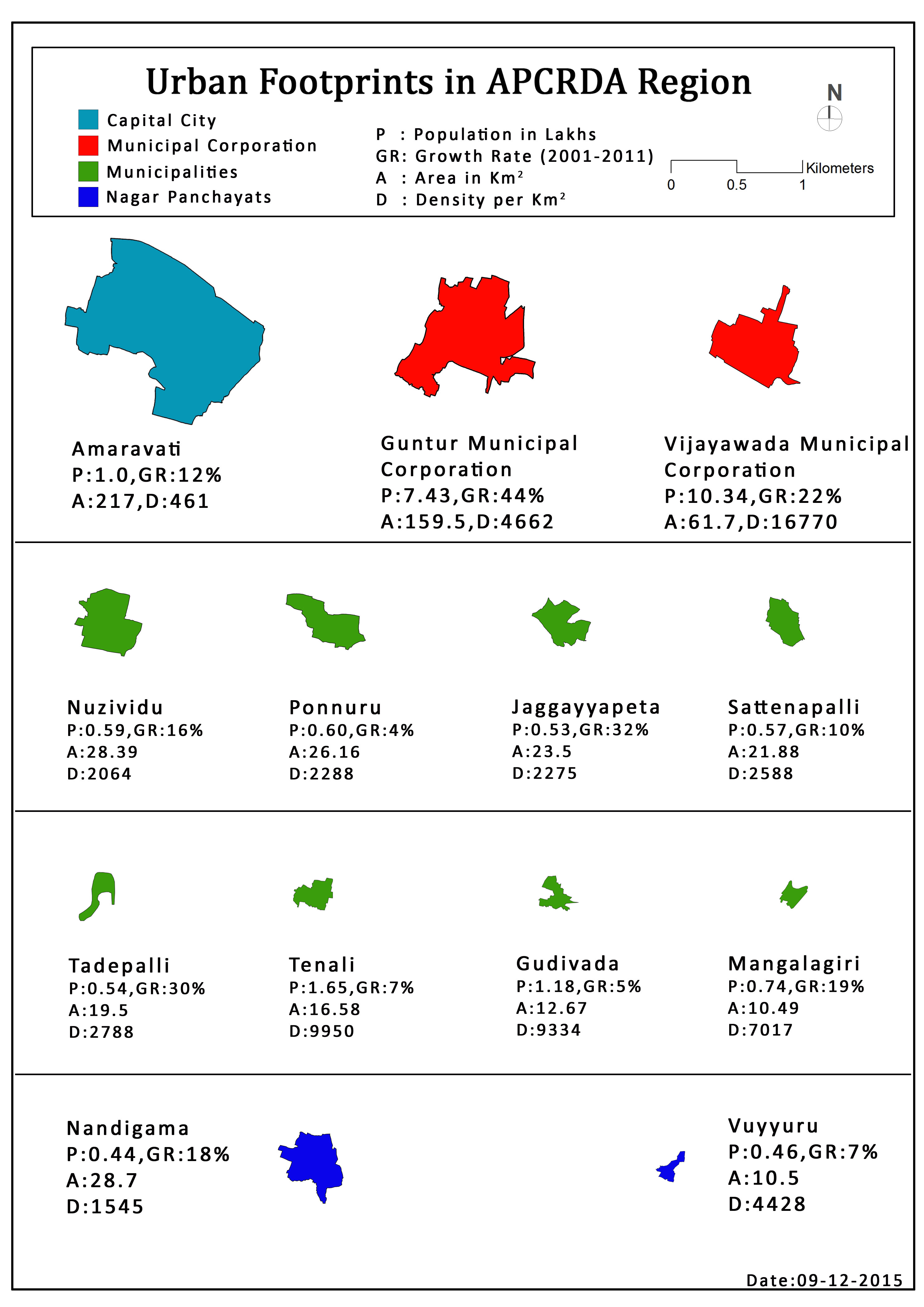
The region is partially spread across 6 districts and subdivided into 8 zones for administrative purposes.[1] It consists of 33 complete and 25 part mandals, totaling 58 mandals with 3 municipal corporations, 10 municipalities and 1006 gram panchayats spanning across 953 revenue villages.[10][11][6][12]
See also[edit | edit source]
References[edit | edit source]
- ↑ "Demography". APCRDA. Government of Andhra Pradesh. Archived from the original (PDF) on 13 September 2016. Retrieved 30 June 2016.
- ↑ "Metropolitan Region Statistics".
- ↑ reddy, u sudhakar (19 August 2016). "Vijayawada is third densely packed city; 31,200 people in every square km". Deccan Chronicle.
- ↑ "A.P. Capital Region" (PDF). APCRDA. Government of Andhra Pradesh. p. 15. Archived from the original (PDF) on 13 September 2016. Retrieved 1 September 2016.
- ↑ Mahalakshmi, BV (22 October 2015). "Foundation stone of Andhra Pradesh's new capital Amaravati laid by PM Narendra Modi". The Financial Express. Archived from the original on 1 July 2016. Retrieved 5 June 2016.
- ↑ 6.0 6.1 "District wise mandals and villages covered in Krishna and Guntur districts" (PDF). Andhra Pradesh Capital Region Development Authority. Government of Andhra Pradesh. Archived from the original (PDF) on 23 September 2015. Retrieved 23 September 2015.
- ↑ "Declaration of A.P. Capital Region" (PDF). APCRDA. Municipal Administration and Urban Development Department. 22 September 2015. Archived from the original (PDF) on 21 February 2016. Retrieved 21 February 2016.
- ↑ Subba Rao, GVR (23 September 2015). "Capital region expands as CRDA redraws boundaries". The Hindu. Vijayawada. Retrieved 31 October 2015.
- ↑ "High court extends status quo on three capitals". The Tribune. 21 September 2020.
- ↑ "Urban Footprints in APCRDA Region". APCRDA. Retrieved 27 June 2016.
- ↑ "AP Capital Region Development Authority comes into being". The Hindu. Hyderabad. 31 December 2014. Retrieved 6 January 2015.
- ↑ "Andhra Pradesh Capital Region Development Authority" (PDF). APCRDA. Government of Andhra Pradesh. Retrieved 12 April 2023.

![[1]](https://crda.ap.gov.in/APCRDADOCS/DataModuleFIles/Maps/01~1324Zones-ULBs.jpg)