



m Removed empty portal template using script |
m correct content as per guidelines and corrected details |
||
| Line 1: | Line 1: | ||
{{ | {{pp|small=yes}} | ||
{{Use dmy dates|date= | {{Use dmy dates|date=May 2024}} | ||
{{Use Indian English|date= | {{Use Indian English|date=May 2024}} | ||
{{Infobox settlement | {{Infobox settlement | ||
| name = Madikeri | | name = Madikeri | ||
| | | other_name = Mercara <!-- Please do not add any Indic script in this infobox, per WP:INDICSCRIPT policy. --> | ||
| nickname = Misty City of Karnataka | | nickname = Misty City of Karnataka | ||
| settlement_type = City | | settlement_type = City | ||
| image_skyline = Coorg_-_The_Scotland_of_India.jpg | | image_skyline = {{Photomontage | ||
| photo1a = Raja's Seat View Point.jpg | |||
| photo2a = Coorg_-_The_Scotland_of_India.jpg | |||
| photo2b = Sri Omkareshwara Temple, Coorg 01.jpg | |||
| photo3a = Gaddige, Raja’s tomb, Madikeri, Coorg.jpg | |||
| photo3b = Abbey Falls 2022 4.jpg | |||
| photo4a = Madikeri Place.jpg | |||
| spacing = 1 | |||
| color_border = white | |||
| color = | |||
| size = 275 | |||
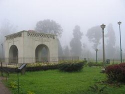
| foot_montage = ''From top, left to right:''<br /> [[Raja's Seat]] View Point, Grasslands in [[Pushpagiri (mountain)|Kumara Parvatha]], Omkareshwara Temple, Gaddige (Raja’s tomb), Abbey Waterfalls, [[Madikeri Fort|Madikeri Palace]] | |||
}} | |||
| image_alt = | | image_alt = | ||
| image_caption = | | image_caption = | ||
| pushpin_map = | | mapframe = yes | ||
| mapframe-zoom = 6 | |||
| map_alt = | |||
| map_caption = Madikeri in Karnataka | |||
| pushpin_map = | |||
| pushpin_map_alt = | | pushpin_map_alt = | ||
| pushpin_map_caption = | | pushpin_map_caption = | ||
| coordinates = {{coord|12.4209|N|75.7397|E|display=inline,title}} | | coordinates = {{coord|12.4209|N|75.7397|E|display=inline,title}} | ||
| subdivision_type = Country | | subdivision_type = Country | ||
| Line 23: | Line 36: | ||
| subdivision_type2 = [[List of districts of India|District]] | | subdivision_type2 = [[List of districts of India|District]] | ||
| subdivision_name2 = [[Kodagu]] | | subdivision_name2 = [[Kodagu]] | ||
| | | blank_name = {{nowrap|[[Official language]]}} | ||
| | | blank_info = [[Kannada]]<ref>{{cite web |url=http://nclm.nic.in/shared/linkimages/NCLM50thReport.pdf |title=50th Report of the Commissioner for Linguistic Minorities in India (July 2012 to June 2013) |access-date=14 January 2015 |url-status=dead |archive-url=https://web.archive.org/web/20160708012438/http://nclm.nic.in/shared/linkimages/NCLM50thReport.pdf |archive-date=8 July 2016}}</ref> | ||
| | |||
| established_title = Muddurajana Keri | |||
| established_date = 1681 | | established_date = 1681 | ||
| founder = Mudduraja | | founder = [[Kingdom of Coorg|Mudduraja]] | ||
| named_for = | | named_for = | ||
| government_type = | | government_type = | ||
| governing_body = [[Nagar panchayat|City Municipal Council]] | | governing_body = [[Nagar panchayat|City Municipal Council]] | ||
| | | leader_title1 = CMC Commissioner | ||
| | | leader_name1 = Ramesh H R | ||
| unit_pref = Metric | | unit_pref = Metric | ||
| area_footnotes = | | area_footnotes = | ||
| Line 39: | Line 53: | ||
| area_rural_km2 = | | area_rural_km2 = | ||
1435.32 | 1435.32 | ||
| elevation_footnotes = | | elevation_footnotes = | ||
| elevation_m = 1170 | | elevation_m = 1170 | ||
| population_total = 33,381 | | population_total = 33,381 | ||
| Line 48: | Line 62: | ||
| population_density_km2 = auto | | population_density_km2 = auto | ||
| population_demonym = | | population_demonym = | ||
| population_footnotes = | | population_footnotes = <ref>{{Cite web|url=https://censusindia.gov.in/nada/index.php/catalog/619/download/2124/DH_2011_2922_PART_B_DCHB_KODAGU.pdf|access-date=1 September 2023|title=Census Data Handbook 2011}}</ref> | ||
| | |||
| | |||
| | |||
| timezone1 = [[Indian Standard Time|IST]] | | timezone1 = [[Indian Standard Time|IST]] | ||
| utc_offset1 = +5:30 | | utc_offset1 = +5:30 | ||
| postal_code_type = [[Postal Index Number|PIN]] | | postal_code_type = [[Postal Index Number|PIN]] | ||
| postal_code = | | postal_code = 571201, 571202 <ref>{{cite web|url=https://www.indiapost.gov.in/post-office-details-name?officename=Vidyanagar%20S.O|access-date=31 January 2026|title=Vidyanagar(Madikeri-02) Post Office}}</ref> | ||
| area_code_type = Telephone code | | area_code_type = Telephone code | ||
| area_code = 08272 | | area_code = 08272 | ||
| registration_plate = KA-12 | | registration_plate = [[List of RTO districts in India#KA—Karnataka|KA-12]] | ||
| website = {{ | | website = {{Url|madikericity.mrc.gov.in}} | ||
| footnotes = | | footnotes = | ||
}} | }} | ||
'''Madikeri''' ({{IPA|kfa|mɐɖikeːri|lang}}), earlier called as '''Mercara''' is city and headquarters of [[Kodagu district]] in the [[Karnataka]] state of India. It is recognised as one of the world's eight "hottest hotspots" of biological diversity and is also a [[UNESCO]] [[World Heritage Site]].<ref>{{cite web | url=https://www.smh.com.au/traveller/inspiration/india-western-ghats-coorg-villas-and-ayurvedic-spa-in-a-world-heritage-biodiverse-hotspot-20190620-h1fk4k.html | title=Western Ghats, Coorg, Western Ghats, India: Villas and ayurvedic spa in a World Heritage bio-diverse hotspot | date=9 July 2019 }}</ref> The city is ranked 1st in India for clean air and [[air quality index]] in 2024.<ref>{{Cite web |date=2024-11-21 |title=India’s top 10 cities with the best air quality in 2024: Global cities’ AQI insights revealed |url=https://indianexpress.com/article/trending/top-10-listing/top-10-indian-cities-with-best-air-quality-index-aqi-2024-9680798/ |access-date= |website=The Indian Express |language=en}}</ref> | |||
'''Madikeri''' is | |||
== Etymology == | == Etymology == | ||
Madikeri was known as ''Muddu Raja Keri'',<ref> | Madikeri was known as ''Muddu Raja Keri'',<ref>{{Cite web|url=https://www.coorg.com/about-coorg/|archiveurl=https://web.archive.org/web/20090426080651/http://www.coorg.com/history.html|url-status=dead|title=About Coorg|archivedate=26 April 2009|website=www.coorg.com}}</ref> which meant Mudduraja's town, was named after the prominent [[Haleri]] king Mudduraja who ruled [[Kodagu]] from 1633 to 1687.<ref>{{Cite book|last=Kushalappa|first=Mookonda|title=1785 Coorg|publisher=Codava Makkada Coota|year=2018|location=Madikeri, Kodagu}}</ref><ref name="Kushalappa 2013">{{Cite book|last=Kushalappa|first=Mookonda|title=The early Coorgs|publisher=Notion Press|year=2013|location=Chennai|language=English}}</ref> From 1834, during the [[British Raj]], it was called ''Mercara''. It was later renamed to Madikeri by the [[Mysore State|Government of Mysore]].<ref>{{Cite book|last=Kushalappa|first=Mookonda Nitin|title=Kodagu principality vs British Empire|publisher=Codava Makkada Coota|year=2018|location=Madikeri, Kodagu|language=English}}</ref><ref>{{Cite book|last=Kushalappa|first=Mookonda|title=Long ago in Coorg|publisher=Pothi|year=2014|location=Chennai|language=English}}</ref> | ||
== History == | == History == | ||
[[File:Madikeri map.jpg|thumb|left|Map c. 1854]] | [[File:Madikeri map.jpg|thumb|left|Map c. 1854]] | ||
The history of Madikeri is related to the history of [[Kodagu]]. From the 2nd to the 6th century AD, the northern part of | The history of Madikeri is related to the history of [[Kodagu]]. From the 2nd to the 6th century AD, the northern part of Kodagu was ruled by [[Kadamba Dynasty|Kadamba]]s. The southern part of Kodagu was ruled by [[Western Ganga dynasty|Gangas]] from the 4th to the 11th century. After defeating the Gangas in the 11th century, [[Chola]]s became the rulers of Kodagu. In the 12th century, the Cholas lost Kodagu to the [[Hoysala]]s. Kodagu fell to the [[Vijayanagara Empire|Vijayanagar]] kings in the 14th century.<ref name="Kushalappa 2013"/> | ||
After their fall, the local chieftains from kodava community (''Palegars'') started ruling their areas directly. They appointed Haleri Dynasty founder Veeraraju, (Nephew of Ikkeri Sadashiva Nayaka who were descendants of Talakadu Ganga Dynasty) as ruler. In the year 1700 AD Ikkeri Somashekara Nayaka gifted Puttur and Amara Sullia Magnes of Tulunadu to Haleri Kings. | |||
Descendants of Veeraraju who are known as "[[Kodagu Kingdom|Haleri Dynasty]]" ruled Kodagu from 1600 to 1834 AD. Haleri king Mudduraja built the Fort in Madikeri and made it<ref name="Tulu gowdas">{{cite book|author=Puttur Anantharaja Gowda|title=IN PURSUIT OF OUR ROOTS|year=2015}}</ref> as their capital. Mudduraja, the third Haleri king started levelling the land around Madikeri and built a fort in the year 1681. [[Madikeri Fort]] which was original built of mud and was replaced by [[Tipu Sultan]]. [[Kodagu]] became a part of [[British India]] after 1834 AD.<ref>Jerry Dupont, ''[https://books.google.com/books?id=pCX660FA5wMC&dq=kodagu+history+British+1834&pg=PA592 The Common Law Abroad]'', Wm. S. Hein Publishing, 2001, {{ISBN|0-8377-3125-9}}, from p 592</ref><ref>{{Cite book|last=Kushalappa|first=Mookonda, Nitin|title=Kodagu principality vs British empire|publisher=Codava Makkada Coota|year=2018|language=English}}</ref> | |||
== Demographics == | == Demographics == | ||
As of the 2011 India census, Madikeri had a population of 33,381. Males constitute 57.2% of the population and females 42.8%. Madikeri had an average literacy rate of 85%, higher than the national average of 69.3: male literacy was 83%, and female literacy 80%. 11% of the population was under 6 years of age.<ref>{{cite web|url=http://www.censusindia.net/results/town.php?stad=A&state5=999|archive-url=https://web.archive.org/web/20040616075334/http://www.censusindia.net/results/town.php?stad=A&state5=999|archive-date=16 June 2004|title= Census of India 2001: Data from the 2001 Census, including cities, villages and towns (Provisional)|access-date=1 November 2008|publisher= Census Commission of India}}</ref> | |||
== Geography and climate == | == Geography and climate == | ||
Madikeri features a tropical highland climate as it has an elevation of {{cvt|1170|m}}. Madikeri is located at {{Coord|12.42|N|75.73|E|}}.<ref>[http://www.fallingrain.com/world/IN/19/Madikeri.html Madikeri], FallingRain.com</ref><ref>{{cite web|url=http://www.fallingrain.com/world/IN/19/Madikeri.html |title=Maps, Weather, and Airports for Madikeri, India|website=www.fallingrain.com}}</ref> Madikeri lies in the [[Western Ghats]] and is a popular hill station. Nearest major cities are [[Hassan, Karnataka|Hassan]] ({{convert|110|km|mi}}) to the north, [[Mangalore | Madikeri features a tropical highland climate as it has an elevation of {{cvt|1170|m}}. Madikeri is located at {{Coord|12.42|N|75.73|E|}}.<ref>[http://www.fallingrain.com/world/IN/19/Madikeri.html Madikeri], FallingRain.com</ref><ref>{{cite web|url=http://www.fallingrain.com/world/IN/19/Madikeri.html |title=Maps, Weather, and Airports for Madikeri, India|website=www.fallingrain.com}}</ref> Madikeri lies in the [[Western Ghats]] and is a popular hill station. Nearest major cities are [[Hassan, Karnataka|Hassan]] ({{convert|110|km|mi}}) to the north, [[Mangalore]] ({{convert|138|km|mi}}) to the north-west, [[Mysore]] ({{convert|120|km|mi}}) to the east and [[Kannur]] of [[Kerala]] to the west ({{cvt|112|km}}). The nearest international airport is [[Kannur International Airport]] which is {{cvt|90|km}} away. | ||
The mean daily minimum temperature is lowest in January at about {{cvt|11|°C}}. Maximum temperature in summer is around {{cvt|24 to 27|°C}}.<ref>[http://cgwb.gov.in/District_Profile/karnataka/KODAGU-BROCHURE.pdf Ground Water Information Booklet], Ministry of Water Resources, 2007. Retrieved 23 June 2011.</ref> With the onset of the south-west monsoon, the temperature decreases in June and the weather becomes chilly. The lowest temperature recorded is {{cvt|4.5|°C}}. | The mean daily minimum temperature is lowest in January at about {{cvt|11|°C}}. Maximum temperature in summer is around {{cvt|24 to 27|°C}}.<ref>[http://cgwb.gov.in/District_Profile/karnataka/KODAGU-BROCHURE.pdf Ground Water Information Booklet], Ministry of Water Resources, 2007. Retrieved 23 June 2011.</ref> With the onset of the south-west monsoon, the temperature decreases in June and the weather becomes chilly. The lowest temperature recorded is {{cvt|4.5|°C}}. | ||
| Line 93: | Line 99: | ||
| single line = Yes | | single line = Yes | ||
| width = auto | | width = auto | ||
|temperature colour = | |temperature colour = | ||
| Jan record high C = 31.7 | | Jan record high C = 31.7 | ||
| Feb record high C = 32.1 | | Feb record high C = 32.1 | ||
| Line 210: | Line 216: | ||
}} | }} | ||
In 2022, Madikeri hobli received an annual rainfall of {{convert|3957|mm|in}}.<ref>{{cite web|url=http://ksndmc.org/en/Root/DownloadFile?path=%5C%5C192.168.2.21%5Ce%24%5CKSNDMC%20REPORTS%5CAnnual%20Report%5CAnnual%20State%20Report%5CAR_2022.pdf&fileName=Annual%20State%20Reports_2022.pdf|access-date=26 July 2023|title=Annual State Report 2022}}{{Dead link|date=July 2025 |bot=InternetArchiveBot |fix-attempted=yes }}</ref> | |||
In the year 2024, Madikeri hobli received {{convert|3878|mm|in}} of rainfall.<ref>{{cite web|url=https://ksndmc.org/en/Root/DownloadFile?path=%5C%5C192.168.2.21%5Ce%24%5CKSNDMC%20REPORTS%5CAnnual%20Report%5CAnnual%20State%20Report%5CAR_2024.pdf&fileName=Annual%20State%20Reports_2024.pdf|access-date=21 March 2025|title=KSNDMC Annual Rainfall report 2024}}</ref> | |||
[[File:Raja seat madikeri.JPG|right|thumb|Raja's Seat, one of the major tourist attractions in Madikeri]] | [[File:Raja seat madikeri.JPG|right|thumb|Raja's Seat, one of the major tourist attractions in Madikeri]] | ||
In 2025, Madikeri received {{convert|3885.1|mm|in}} of annual rainfall.<ref>{{cite web|url=https://www.ksndmc.org/en/Root/DownloadFile?path=%5C%5C192.168.2.21%5Ce%24%5CKSNDMC%20REPORTS%5CAnnual%20Report%5CAnnual%20State%20Report%5CAR_2025.pdf&fileName=Annual%20State%20Reports_2025.pdf|access-date=26 February 2026|title=KSNDMC Annual Report 2025;pg 31}}</ref> | |||
==Transportation== | ==Transportation== | ||
[[File: | [[File:Chelavara Water Falls and surroundings (9).jpg|thumb|[[Chelavara Falls]] near Virajpet]] | ||
The town has only one mode of transport; The Roadways. | The town has only one mode of transport; The Roadways. | ||
Public transport is maintained by buses of [[Karnataka State Road Transport Corporation|KSRTC]] and other private buses. It also houses a [[List of bus depots in Karnataka|KSRTC Bus Depot]] under [[Puttur, Karnataka|Puttur]] division. Inter-district and interstate buses are handled by KSRTC, providing connectivity to cities like | Public transport is maintained by buses of [[Karnataka State Road Transport Corporation|KSRTC]] and other private buses. It also houses a [[List of bus depots in Karnataka|KSRTC Bus Depot]] under [[Puttur, Karnataka|Puttur]] division. Inter-district and interstate buses are handled by KSRTC, providing connectivity to cities like [[Mangalore]], [[Mysore]], [[Bengaluru]], [[Hubli]], [[Madurai]], [[Coimbatore]] and many more other minor cities. Nearest international airports are [[Kannur International Airport]] and [[Mangalore International Airport]] at 90 km and 140 km, respectively. | ||
===Highways=== | ===Highways=== | ||
The [[List of state highways in Karnataka|SH-88]] was upgraded to [[National Highway 275 (India)|NH-275]] (subsidiary of [[National Highway 75 (India)|NH-75]]) making it the only National Highway passing through the district of [[Kodagu]]. NH-275 connects Madikeri to | The [[List of state highways in Karnataka|SH-88]] was upgraded to [[National Highway 275 (India)|NH-275]] (subsidiary of [[National Highway 75 (India)|NH-75]]) making it the only National Highway passing through the district of [[Kodagu]]. NH-275 connects Madikeri to Mysore and Bengaluru due east and to Mangalore due west. Other state highways passing through Madikeri are [[State Highway 27 (Karnataka)|SH-27 (Virajpet-Byndoor)]] and [[State Highway 89 (Karnataka)|SH-89 (Madikeri-Kutta)]]. | ||
== Tourist | == Tourist attractions == | ||
[[File:Madikeri Fort Museum.jpg|thumb|Government Museum in Madikeri, formerly St. Mark's Church]] | |||
* [[Raja's Seat]] | * [[Raja's Seat]] | ||
* Sri Omkareshwara Temple | * Sri Omkareshwara Temple | ||
* Madikeri Fort | * [[Madikeri Fort]] | ||
* Gaddide ([[Raja's Tomb]]) | * Gaddide ([[Raja's Tomb]]) | ||
* [[General Thimmaiah War Museum]] | * [[General Thimmaiah War Museum]] | ||
| Line 231: | Line 243: | ||
== See also == | == See also == | ||
{{Portal|India}} | |||
* [[Kodagu Institute of Medical Sciences]] | * [[Kodagu Institute of Medical Sciences]] | ||
* [[Sakleshpur]] | * [[Sakleshpur]] | ||
* [[Kodava people|Kodava]] | * [[Kodava people|Kodava]] | ||
| Line 243: | Line 253: | ||
== External links == | == External links == | ||
{{commons category|Madikeri}} | |||
* | * {{wikivoyage inline|Madikeri}} | ||
* [http://madikeri.org Madikeri.org: Portal on Madikeri and Coorg] | * [http://madikeri.org Madikeri.org: Portal on Madikeri and Coorg] {{Webarchive|url=https://web.archive.org/web/20101204194922/http://madikeri.org/ |date=4 December 2010 }} | ||
* [http://www.kaladarshana.com/sites/madikeri Madikeri: History and Architecture] | * {{usurped|1=[https://web.archive.org/web/20081120163616/http://www.kaladarshana.com/sites/madikeri Madikeri: History and Architecture]}} | ||
{{Kodagu (Coorg) topics}} | {{Kodagu (Coorg) topics}} | ||
| Line 252: | Line 262: | ||
{{Authority control}} | {{Authority control}} | ||
[[Category:Kodava people]] | [[Category:Kodava people]] | ||
[[Category:Kodava Takk]] | [[Category:Kodava Takk]] | ||
| Line 261: | Line 269: | ||
[[Category:Hill stations in Karnataka]] | [[Category:Hill stations in Karnataka]] | ||
[[Category:Hills of Karnataka]] | [[Category:Hills of Karnataka]] | ||
[[Category:Former | [[Category:Former capitals in India]] | ||
[[Category:Geography of Kodagu district]] | [[Category:Geography of Kodagu district]] | ||
[[Category:Tourist attractions in Kodagu district]] | [[Category:Tourist attractions in Kodagu district]] | ||
Revision as of 04:26, 14 March 2026
Madikeri
Mercara | |
|---|---|
City | |
      From top, left to right: Raja's Seat View Point, Grasslands in Kumara Parvatha, Omkareshwara Temple, Gaddige (Raja’s tomb), Abbey Waterfalls, Madikeri Palace | |
| Nickname: Misty City of Karnataka | |
| Coordinates: 12°25′15″N 75°44′23″E / 12.4209°N 75.7397°E | |
| Country |  India India |
| State |  Karnataka Karnataka |
| District | Kodagu |
| Muddurajana Keri | 1681 |
| Founded by | Mudduraja |
| Government | |
| • Body | City Municipal Council |
| • CMC Commissioner | Ramesh H R |
| Area | |
| • City | 17.04 km2 (6.58 sq mi) |
| • Rural | 1,435.32 km2 (554.18 sq mi) |
| Elevation | 1,170 m (3,840 ft) |
| Population (2011)[1] | |
| • City | 33,381 |
| • Density | 2,000/km2 (5,100/sq mi) |
| • Rural | 113,202 |
| Time zone | UTC+5:30 (IST) |
| PIN | 571201, 571202 [2] |
| Telephone code | 08272 |
| Vehicle registration | KA-12 |
| Official language | Kannada[3] |
| Website | madikericity |
Madikeri (Kodava: [mɐɖikeːri]), earlier called as Mercara is city and headquarters of Kodagu district in the Karnataka state of India. It is recognised as one of the world's eight "hottest hotspots" of biological diversity and is also a UNESCO World Heritage Site.[4] The city is ranked 1st in India for clean air and air quality index in 2024.[5]
Etymology
Madikeri was known as Muddu Raja Keri,[6] which meant Mudduraja's town, was named after the prominent Haleri king Mudduraja who ruled Kodagu from 1633 to 1687.[7][8] From 1834, during the British Raj, it was called Mercara. It was later renamed to Madikeri by the Government of Mysore.[9][10]
History

The history of Madikeri is related to the history of Kodagu. From the 2nd to the 6th century AD, the northern part of Kodagu was ruled by Kadambas. The southern part of Kodagu was ruled by Gangas from the 4th to the 11th century. After defeating the Gangas in the 11th century, Cholas became the rulers of Kodagu. In the 12th century, the Cholas lost Kodagu to the Hoysalas. Kodagu fell to the Vijayanagar kings in the 14th century.[8]
After their fall, the local chieftains from kodava community (Palegars) started ruling their areas directly. They appointed Haleri Dynasty founder Veeraraju, (Nephew of Ikkeri Sadashiva Nayaka who were descendants of Talakadu Ganga Dynasty) as ruler. In the year 1700 AD Ikkeri Somashekara Nayaka gifted Puttur and Amara Sullia Magnes of Tulunadu to Haleri Kings.
Descendants of Veeraraju who are known as "Haleri Dynasty" ruled Kodagu from 1600 to 1834 AD. Haleri king Mudduraja built the Fort in Madikeri and made it[11] as their capital. Mudduraja, the third Haleri king started levelling the land around Madikeri and built a fort in the year 1681. Madikeri Fort which was original built of mud and was replaced by Tipu Sultan. Kodagu became a part of British India after 1834 AD.[12][13]
Demographics
As of the 2011 India census, Madikeri had a population of 33,381. Males constitute 57.2% of the population and females 42.8%. Madikeri had an average literacy rate of 85%, higher than the national average of 69.3: male literacy was 83%, and female literacy 80%. 11% of the population was under 6 years of age.[14]
Geography and climate
Madikeri features a tropical highland climate as it has an elevation of 1,170 m (3,840 ft). Madikeri is located at 12°25′N 75°44′E / 12.42°N 75.73°E.[15][16] Madikeri lies in the Western Ghats and is a popular hill station. Nearest major cities are Hassan (110 kilometres (68 mi)) to the north, Mangalore (138 kilometres (86 mi)) to the north-west, Mysore (120 kilometres (75 mi)) to the east and Kannur of Kerala to the west (112 km (70 mi)). The nearest international airport is Kannur International Airport which is 90 km (56 mi) away.
The mean daily minimum temperature is lowest in January at about 11 °C (52 °F). Maximum temperature in summer is around 24 to 27 °C (75 to 81 °F).[17] With the onset of the south-west monsoon, the temperature decreases in June and the weather becomes chilly. The lowest temperature recorded is 4.5 °C (40.1 °F).
| Climate data for Madikeri (1981–2010, extremes 1901–2012) | |||||||||||||
|---|---|---|---|---|---|---|---|---|---|---|---|---|---|
| Month | Jan | Feb | Mar | Apr | May | Jun | Jul | Aug | Sep | Oct | Nov | Dec | Year |
| Record high °C (°F) | 31.7 (89.1) |
32.1 (89.8) |
34.2 (93.6) |
34.2 (93.6) |
35.0 (95.0) |
32.2 (90.0) |
28.9 (84.0) |
31.0 (87.8) |
30.0 (86.0) |
30.3 (86.5) |
28.5 (83.3) |
29.0 (84.2) |
35.0 (95.0) |
| Average high °C (°F) | 26.4 (79.5) |
28.2 (82.8) |
29.8 (85.6) |
29.4 (84.9) |
27.5 (81.5) |
23.3 (73.9) |
21.6 (70.9) |
21.6 (70.9) |
23.6 (74.5) |
25.0 (77.0) |
25.3 (77.5) |
25.3 (77.5) |
25.6 (78.1) |
| Average low °C (°F) | 12.4 (54.3) |
13.1 (55.6) |
15.0 (59.0) |
17.5 (63.5) |
18.1 (64.6) |
17.6 (63.7) |
17.2 (63.0) |
17.2 (63.0) |
17.1 (62.8) |
16.9 (62.4) |
15.6 (60.1) |
13.2 (55.8) |
15.9 (60.6) |
| Record low °C (°F) | 4.8 (40.6) |
5.1 (41.2) |
7.6 (45.7) |
10.6 (51.1) |
9.4 (48.9) |
9.2 (48.6) |
8.8 (47.8) |
9.5 (49.1) |
10.0 (50.0) |
10.6 (51.1) |
7.9 (46.2) |
5.5 (41.9) |
4.8 (40.6) |
| Average rainfall mm (inches) | 1.6 (0.06) |
3.0 (0.12) |
15.0 (0.59) |
65.3 (2.57) |
128.7 (5.07) |
646.3 (25.44) |
952.5 (37.50) |
821.0 (32.32) |
274.7 (10.81) |
211.0 (8.31) |
70.8 (2.79) |
20.0 (0.79) |
3,210 (126.38) |
| Average rainy days | 0.2 | 0.3 | 1.6 | 5.0 | 7.8 | 22.2 | 27.0 | 26.2 | 16.2 | 12.2 | 4.4 | 1.1 | 124.1 |
| Average relative humidity (%) (at 17:30 IST) | 58 | 55 | 57 | 69 | 77 | 90 | 93 | 93 | 88 | 83 | 74 | 65 | 76 |
| Source: India Meteorological Department[18][19] | |||||||||||||
In 2022, Madikeri hobli received an annual rainfall of 3,957 millimetres (155.8 in).[20]
In the year 2024, Madikeri hobli received 3,878 millimetres (152.7 in) of rainfall.[21]

In 2025, Madikeri received 3,885.1 millimetres (152.96 in) of annual rainfall.[22]
Transportation
.jpg)
The town has only one mode of transport; The Roadways. Public transport is maintained by buses of KSRTC and other private buses. It also houses a KSRTC Bus Depot under Puttur division. Inter-district and interstate buses are handled by KSRTC, providing connectivity to cities like Mangalore, Mysore, Bengaluru, Hubli, Madurai, Coimbatore and many more other minor cities. Nearest international airports are Kannur International Airport and Mangalore International Airport at 90 km and 140 km, respectively.
Highways
The SH-88 was upgraded to NH-275 (subsidiary of NH-75) making it the only National Highway passing through the district of Kodagu. NH-275 connects Madikeri to Mysore and Bengaluru due east and to Mangalore due west. Other state highways passing through Madikeri are SH-27 (Virajpet-Byndoor) and SH-89 (Madikeri-Kutta).
Tourist attractions

- Raja's Seat
- Sri Omkareshwara Temple
- Madikeri Fort
- Gaddide (Raja's Tomb)
- General Thimmaiah War Museum
- Abbey Falls
- Mandalpatti view point
- Pushpagiri Wildlife Sanctuary
See also

References
- ↑ "Census Data Handbook 2011" (PDF). Retrieved 1 September 2023.
- ↑ "Vidyanagar(Madikeri-02) Post Office". Retrieved 31 January 2026.
- ↑ "50th Report of the Commissioner for Linguistic Minorities in India (July 2012 to June 2013)" (PDF). Archived from the original (PDF) on 8 July 2016. Retrieved 14 January 2015.
- ↑ "Western Ghats, Coorg, Western Ghats, India: Villas and ayurvedic spa in a World Heritage bio-diverse hotspot". 9 July 2019.
- ↑ "India's top 10 cities with the best air quality in 2024: Global cities' AQI insights revealed". The Indian Express. 21 November 2024.
- ↑ "About Coorg". www.coorg.com. Archived from the original on 26 April 2009.
- ↑ Kushalappa, Mookonda (2018). 1785 Coorg. Madikeri, Kodagu: Codava Makkada Coota.
- ↑ 8.0 8.1 Kushalappa, Mookonda (2013). The early Coorgs. Chennai: Notion Press.
- ↑ Kushalappa, Mookonda Nitin (2018). Kodagu principality vs British Empire. Madikeri, Kodagu: Codava Makkada Coota.
- ↑ Kushalappa, Mookonda (2014). Long ago in Coorg. Chennai: Pothi.
- ↑ Puttur Anantharaja Gowda (2015). IN PURSUIT OF OUR ROOTS.
- ↑ Jerry Dupont, The Common Law Abroad, Wm. S. Hein Publishing, 2001, ISBN 0-8377-3125-9, from p 592
- ↑ Kushalappa, Mookonda, Nitin (2018). Kodagu principality vs British empire. Codava Makkada Coota.
{{cite book}}: CS1 maint: multiple names: authors list (link) - ↑ "Census of India 2001: Data from the 2001 Census, including cities, villages and towns (Provisional)". Census Commission of India. Archived from the original on 16 June 2004. Retrieved 1 November 2008.
- ↑ Madikeri, FallingRain.com
- ↑ "Maps, Weather, and Airports for Madikeri, India". www.fallingrain.com.
- ↑ Ground Water Information Booklet, Ministry of Water Resources, 2007. Retrieved 23 June 2011.
- ↑ "Station: Madikeri/Mercara Climatological Table 1981–2010" (PDF). Climatological Normals 1981–2010. India Meteorological Department. January 2015. pp. 489–490. Archived from the original (PDF) on 5 February 2020. Retrieved 19 April 2020.
- ↑ "Extremes of Temperature & Rainfall for Indian Stations (Up to 2012)" (PDF). India Meteorological Department. December 2016. p. M99. Archived from the original (PDF) on 5 February 2020. Retrieved 19 April 2020.
- ↑ "Annual State Report 2022" (PDF). Retrieved 26 July 2023.[permanent dead link]
- ↑ "KSNDMC Annual Rainfall report 2024" (PDF). Retrieved 21 March 2025.
- ↑ "KSNDMC Annual Report 2025;pg 31" (PDF). Retrieved 26 February 2026.
External links
- Pages using the JsonConfig extension
- Pages with Kodava IPA
- Kodava people
- Kodava Takk
- Cities and towns in Kodagu district
- Populated places in the Western Ghats
- Tourism in Karnataka
- Hill stations in Karnataka
- Hills of Karnataka
- Former capitals in India
- Geography of Kodagu district
- Tourist attractions in Kodagu district