.svg)
Krishnavati river: Difference between revisions
CleanupBot (talk | contribs) m (→Tributaries: clean up) |
m (robot: Update article (please report if you notice any mistake or error in this edit)) |
||
| Line 4: | Line 4: | ||
{{Infobox river | {{Infobox river | ||
| name = | | name = | ||
| | | native_name ={{native name|hi|कृष्णावती नदी or कसौंती नदी}} | ||
| name_other = Kasaunti river | | name_other = Kasaunti river | ||
| etymology = | | etymology = | ||
| Line 40: | Line 39: | ||
}} | }} | ||
The '''Krishnavati''' river ({{lang-hi|कृष्णावती नदी}}), also called '''Kasaunti''' ({{lang-hi|कसौंती नदी}}), is a rain-fed river originates from [[Aravalli Range]] near [[Dariba, Rajasthan|Dariba]] copper mines in [[Rajsamand district]] of Rajasthan, and flows through [[Patan, Rajasthan|Patan]] in [[Dausa district]] and Mothooka in [[Alwar district]] and then disappears in [[Mahendragarh district]] in [[Haryana]] where it use to be a tributary of [[Sahibi River]], which in turn still is a tributary of [[Yamuna]].<ref name="Sahibi1">[http://www.indiamapped.in/revers-in-india/haryana/sahibi-river Sahibi river]</ref><ref name="AKjain"/><ref name=Dariba>[https://books.google.com/books?isbn=812460049X Minerals and Metals in Ancient India: Archaeological evidence], Arun Kumar Biswas, Sulekha Biswas, University of Michigan. 1996. {{ISBN|812460049X}}.</ref> Several [[Ochre Coloured Pottery culture]] sites (also identified as late Harappan phase of [[Indus Valley | The '''Krishnavati''' river ({{lang-hi|कृष्णावती नदी}}), also called '''Kasaunti''' ({{lang-hi|कसौंती नदी}}), is a rain-fed river originates from [[Aravalli Range]] near [[Dariba, Rajasthan|Dariba]] copper mines in [[Rajsamand district]] of Rajasthan, and flows through [[Patan, Rajasthan|Patan]] in [[Dausa district]] and Mothooka in [[Alwar district]] and then disappears in [[Mahendragarh district]] in [[Haryana]] where it use to be a tributary of [[Sahibi River]], which in turn still is a tributary of [[Yamuna]].<ref name="Sahibi1">[http://www.indiamapped.in/revers-in-india/haryana/sahibi-river Sahibi river]</ref><ref name="AKjain"/><ref name=Dariba>[https://books.google.com/books?isbn=812460049X Minerals and Metals in Ancient India: Archaeological evidence], Arun Kumar Biswas, Sulekha Biswas, University of Michigan. 1996. {{ISBN|812460049X}}.</ref> Several [[Ochre Coloured Pottery culture]] sites (also identified as late Harappan phase of [[Indus Valley civilisation]] culture)<ref name=IVCOCP>{{Citation | editor-last = Gupta | editor-first = S.P. | title = The lost Sarasvati and the Indus Civilization | place = Jodhpur | publisher = Kusumanjali Prakashan | year = 1995}}</ref> have been found along the banks of Krishnavati, Sahibi river, [[Dohan river]] (another tributary of Sahibi river originates near [[Neem Ka Thana]] in Alwar district) and Sota River (another tributaries of Sahibi river that merges with Sahibi at [[Behror]] in Alwar district).<ref name=Dariba/><ref name=culture1>[https://books.google.com/books?isbn=0391023586 Cultural Contours of India: Dr. Satya Prakash Felicitation Volume, Vijai Shankar Śrivastava, 1981]. {{ISBN|0391023586}}</ref> The drainage pattern for all these rivers is [[Drainage system (geomorphology)#Dendritic drainage pattern|dendritic]]. | ||
==Basin== | ==Basin== | ||
| Line 47: | Line 46: | ||
== Tributaries == | == Tributaries == | ||
These west to north-west flowing rivers originate from the western slopes of [[Aravalli range]] in Rajasthan, flow through semi-arid historical [[Shekhawati]] region, drain into southern Haryana. | These west to north-west flowing rivers originate from the western slopes of [[Aravalli range]] in Rajasthan, flow through semi-arid historical [[Shekhawati]] region, drain into southern Haryana. | ||
* [[Sahibi River]], originates near [[Manoharpur]] in [[Sikar district]] flows through Haryana, along with its following tributaries:<ref name="Sahibi1"/><ref name=AKjain>[https://books.google.com/books?id=1PjJD61h8Q0C&pg=PA41&lpg=PA41&dq=sahibi+river&source=bl&ots=VGgGSr5-B3&sig=RY20djGqyiszeWbQDiZCH3nt5TY&hl=en&sa=X&ei=90UkUNi9DpOe6QG1sIDAAg&ved=0CEgQ6AEwBA#v=onepage&q=sahibi%20river&f=falseGoogle Books: Page 41, 42, 43, 44, 47 (b) Sahibi Nadi (River), River Pollution, By A.k.jain]</ref><ref name=Dariba | * [[Sahibi River]], originates near [[Manoharpur]] in [[Sikar district]] flows through Haryana, along with its following tributaries:<ref name=culture1/><ref name="Sahibi1"/><ref name=AKjain>[https://books.google.com/books?id=1PjJD61h8Q0C&pg=PA41&lpg=PA41&dq=sahibi+river&source=bl&ots=VGgGSr5-B3&sig=RY20djGqyiszeWbQDiZCH3nt5TY&hl=en&sa=X&ei=90UkUNi9DpOe6QG1sIDAAg&ved=0CEgQ6AEwBA#v=onepage&q=sahibi%20river&f=falseGoogle Books: Page 41, 42, 43, 44, 47 (b) Sahibi Nadi (River), River Pollution, By A.k.jain]</ref><ref name=Dariba/> | ||
** [[Dohan river]], tributary of Sahibi river, originates near [[Neem Ka Thana]] in Alwar district). | ** [[Dohan river]], tributary of Sahibi river, originates near [[Neem Ka Thana]] in Alwar district). | ||
** [[Sota River, India|Sota River]], tributary of Sahibi river, merges with Sahibi river at [[Behror]] in Alwar district. | ** [[Sota River, India|Sota River]], tributary of Sahibi river, merges with Sahibi river at [[Behror]] in Alwar district. | ||
| Line 58: | Line 57: | ||
== Identification with Vedic rivers == | == Identification with Vedic rivers == | ||
{{See also|Drishadvati river}} | {{See also|Drishadvati river}} | ||
Several modern scholars identify the old [[Ghaggar-Hakra River]] (of which Tangri river is a tributary) as the [[Sarasvati river]] and the [[Sahibi River]] with the [[Drishadvati river]] of [[Vedic period]], on the banks of which [[Indus Valley | Several modern scholars identify the old [[Ghaggar-Hakra River]] (of which Tangri river is a tributary) as the [[Sarasvati river]] and the [[Sahibi River]] with the [[Drishadvati river]] of [[Vedic period]], on the banks of which [[Indus Valley civilisation|Indus–Sarasvati civilisation]] developed. such scholars include Bhargava<ref>"Location of Brahmavarta and Drishadwati River is important to find earliest alignment of Saraswati River", Sudhir Bhargava, International Conference, 20–22 Nov. 2009, "Saraswati-a perspective" pages 114–117, [[Kurukshetra University]], Kurukshetra, Organised by: Saraswati Nadi Shodh Sansthan, Haryana.</ref> The [[Drishadwati]] River formed one border of the [[Vedic]] state of [[Brahmavarta]] and was mentioned in the ''[[Rigveda]]'', the ''[[Manusmriti]]'', and the ''Brahmin Granths'' texts. | ||
== Gallery == | == Gallery == | ||
<gallery> | <gallery> | ||
IVC-major-sites-2.jpg|[[Indus Valley | IVC-major-sites-2.jpg|[[Indus Valley civilisation|Indus–Sarasvati civilisation]] major sites | ||
Ghaggar river in Panchkula.jpg|[[Ghaggar-Hakra River|Ghaggar river]] flowing through [[Panchkula]] in [[Haryana]] | Ghaggar river in Panchkula.jpg|[[Ghaggar-Hakra River|Ghaggar river]] flowing through [[Panchkula]] in [[Haryana]] | ||
</gallery> | </gallery> | ||
| Line 106: | Line 105: | ||
[[Category:Archaeological sites in Rajasthan]] | [[Category:Archaeological sites in Rajasthan]] | ||
[[Category:Indus basin]] | [[Category:Indus basin]] | ||
[[Category:Indus Valley | [[Category:Indus Valley civilisation sites]] | ||
[[Category:Rigvedic rivers]] | [[Category:Rigvedic rivers]] | ||
[[Category:Rivers of India]] | [[Category:Rivers of India]] | ||
Latest revision as of 11:23, 27 June 2022
Kasaunti river | |
|---|---|
| Native name | कृष्णावती नदी or कसौंती नदी (Hindi) |
| Location | |
| Country | India |
| Physical characteristics | |
| Source | |
| • location | Aravalli Range, From Alwar district and Sikar district of Rajasthan to Rewari district of Haryana |
| Mouth | |
• location | Delhi |
| Length | 30 km (19 mi) |
| Discharge | |
| • location | Sahibi River in Haryana |
| Basin features | |
| Waterbodies | Norana Check Dam |
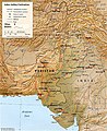
The Krishnavati river (Hindi: कृष्णावती नदी), also called Kasaunti (Hindi: कसौंती नदी), is a rain-fed river originates from Aravalli Range near Dariba copper mines in Rajsamand district of Rajasthan, and flows through Patan in Dausa district and Mothooka in Alwar district and then disappears in Mahendragarh district in Haryana where it use to be a tributary of Sahibi River, which in turn still is a tributary of Yamuna.[1][2][3] Several Ochre Coloured Pottery culture sites (also identified as late Harappan phase of Indus Valley civilisation culture)[4] have been found along the banks of Krishnavati, Sahibi river, Dohan river (another tributary of Sahibi river originates near Neem Ka Thana in Alwar district) and Sota River (another tributaries of Sahibi river that merges with Sahibi at Behror in Alwar district).[3][5] The drainage pattern for all these rivers is dendritic.
Basin[edit]
The western slopes of Aravalli range in Rajasthan and southern Haryana forms the basin of this river. The drainage pattern is dendritic.
Tributaries[edit]
These west to north-west flowing rivers originate from the western slopes of Aravalli range in Rajasthan, flow through semi-arid historical Shekhawati region, drain into southern Haryana.
- Sahibi River, originates near Manoharpur in Sikar district flows through Haryana, along with its following tributaries:[5][1][2][3]
- Dohan river, tributary of Sahibi river, originates near Neem Ka Thana in Alwar district).
- Sota River, tributary of Sahibi river, merges with Sahibi river at Behror in Alwar district.
- Krishnavati river, former tributary of Sahibi river, originates near Dariba copper mines in Rajsamand district of Rajasthan, flows through Patan in Dausa district and Mothooka in Alwar district, then disappears in Mahendragarh district in Haryana much before reaching Sahibi river.
Archaeological findings[edit]

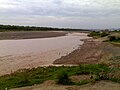
Archaeological findings on the Sahibi River have confirmed habitations on its banks before the Harappan and pre-Mahabharata periods. Both handmade and wheel-made earthenware dated from 3309–2709 BCE and 2879–2384 BCE has been found on the banks of the Sahibi River at Jodhpura. INTACH-Rewari found pottery on the Sahibi riverbed at Hansaka in the Rewari district. A red stone statue of Vamana Dev was found in the Sahibi riverbed near Bawal in 2002; the statue is now displayed at the Shri Krishna Museum, Kurukshetra.[citation needed] Other artifacts discovered in the Sahibi River include arrowheads, fishhooks, appearheads, awls, and chisels.[6]
Identification with Vedic rivers[edit]
Several modern scholars identify the old Ghaggar-Hakra River (of which Tangri river is a tributary) as the Sarasvati river and the Sahibi River with the Drishadvati river of Vedic period, on the banks of which Indus–Sarasvati civilisation developed. such scholars include Bhargava[7] The Drishadwati River formed one border of the Vedic state of Brahmavarta and was mentioned in the Rigveda, the Manusmriti, and the Brahmin Granths texts.
Gallery[edit]
Indus–Sarasvati civilisation major sites
Ghaggar river flowing through Panchkula in Haryana


See also[edit]
- Krishnavati river
- Dangri, a tributary of Sarsuti
- Tangri river, a tributary of Sarsuti, merge if Dangri and Tangri are same
- Sarsuti, a tributary of Ghaggar-Hakra River
- Kaushalya river, a tributary of Ghaggar-Hakra River
- Chautang, a tributary of Ghaggar-Hakra River
- Sutlej, a tributary of Indus
- Ganges
- Indus
- Western Yamuna Canal, branches off Yamuna
- List of rivers of Rajasthan
- List of rivers of India
- List of dams and reservoirs in India
External links[edit]
- Sarasvati-Sindhu civilization and Sarasvati River
- The Saraswati: Where lies the mystery by Saswati Paik
References[edit]
- ↑ 1.0 1.1 Sahibi river
- ↑ 2.0 2.1 Books: Page 41, 42, 43, 44, 47 (b) Sahibi Nadi (River), River Pollution, By A.k.jain
- ↑ 3.0 3.1 3.2 Minerals and Metals in Ancient India: Archaeological evidence, Arun Kumar Biswas, Sulekha Biswas, University of Michigan. 1996. ISBN 812460049X.
- ↑ Gupta, S.P., ed. (1995), The lost Sarasvati and the Indus Civilization, Jodhpur: Kusumanjali Prakashan
- ↑ 5.0 5.1 Cultural Contours of India: Dr. Satya Prakash Felicitation Volume, Vijai Shankar Śrivastava, 1981. ISBN 0391023586
- ↑ A History of Ancient and Early Medieval India from the stone age to the 12th century, Pearson 2009, page 116
- ↑ "Location of Brahmavarta and Drishadwati River is important to find earliest alignment of Saraswati River", Sudhir Bhargava, International Conference, 20–22 Nov. 2009, "Saraswati-a perspective" pages 114–117, Kurukshetra University, Kurukshetra, Organised by: Saraswati Nadi Shodh Sansthan, Haryana.
Coordinates: 28°29′N 76°44′E / 28.483°N 76.733°E