

imported>NearEMPTiness No edit summary |
SidneyBecnel (talk | contribs) m reworked section to improve readability and improved wording based on references |
||
| Line 6: | Line 6: | ||
{{Use Indian English|date=July 2018}} | {{Use Indian English|date=July 2018}} | ||
{{Infobox settlement | {{Infobox settlement | ||
| name | | name = Korutla | ||
| official_name | | official_name = | ||
| native_name | | native_name = కోరుట్ల | ||
| other_name = Korutla | |||
| other_name | | settlement_type = [[Town]] | ||
| image_skyline = Korutla Railway Station(1).jpg | |||
| settlement_type | | image_alt = | ||
| image_skyline | | image_caption = Korutla Railway Station | ||
| image_alt | | pushpin_map = India Telangana#India | ||
| image_caption | | pushpin_label_position = right | ||
| pushpin_map | | pushpin_map_alt = | ||
| pushpin_label_position | | pushpin_map_caption = Location in Telangana, India | ||
| pushpin_map_alt | | coordinates = {{coord|18.8215|N|78.7119|E|display=inline,title}} | ||
| pushpin_map_caption | | subdivision_type = Country | ||
| coordinates | | subdivision_name = {{flag|India}} | ||
| subdivision_type | | subdivision_type1 = [[States and territories of India|State]] | ||
| subdivision_name | | subdivision_name1 = [[Telangana]] | ||
| subdivision_type1 | | subdivision_type2 = [[List of districts of India|District]] | ||
| subdivision_name1 | | subdivision_name2 = [[Jagtial district|Jagtial]] | ||
| subdivision_type2 | | subdivision_type3 = [[List of regions of India|Region]] | ||
| subdivision_name2 | | subdivision_name3 = Deccan | ||
| subdivision_type3 | | established_title = <!-- Established --> | ||
| subdivision_name3 | | established_date = | ||
| established_title | | founder = | ||
| established_date | | named_for = | ||
| founder | | government_type = Municipal Council | ||
| named_for | | governing_body = Korutla Municipality | ||
| government_type | | unit_pref = Metric | ||
| governing_body | | area_footnotes = <ref name="civicbody">{{cite web|title=Urban Local Body Information|url=http://www.dtcp.telangana.gov.in/ULBs-List-68.pdf|website=Directorate of Town and Country Planning|publisher=Government of Telangana|access-date=28 June 2016|archive-url=https://web.archive.org/web/20160615135503/http://dtcp.telangana.gov.in/ULBs-List-68.pdf|archive-date=15 June 2016}}</ref> | ||
| unit_pref | | area_rank = 2 | ||
| area_footnotes | | area_total_km2 = 34.12 | ||
| area_rank | | elevation_footnotes = <ref name=geo>{{cite web|url=http://www.fallingrain.com/world/IN/02/Koratla.html|title=Maps, Weather, and Airports for Koratla, India|work=fallingrain.com}}</ref> | ||
| area_total_km2 | | elevation_m = 287 | ||
| elevation_footnotes | | population_total = 89,215 | ||
| elevation_m | | population_as_of = 2018 | ||
| population_total | | population_density_km2 = auto | ||
| population_as_of | | population_demonym = | ||
| population_footnotes = <ref name="basic">{{cite web|title=Basic information of municipity|url=https://korultamunicipality.telamgana.gov.in/pases/basic-information|website=Official Site of Korutla Municipality}}</ref> | |||
| population_density_km2 | | demographics_type1 = Languages | ||
| population_demonym | | demographics1_title1 = Official | ||
| population_footnotes | | demographics1_info1 = [[Telugu language|Telugu]] | ||
| demographics_type1 | | timezone1 = [[Indian Standard Time|IST]] | ||
| demographics1_title1 | | utc_offset1 = +5:30 | ||
| demographics1_info1 | | postal_code_type = [[Postal Index Number|PIN]] | ||
| timezone1 | | postal_code = 505326 | ||
| utc_offset1 | | area_code_type = Telephone code | ||
| postal_code_type | | area_code = 08725 | ||
| postal_code | | registration_plate = TS21 | ||
| area_code_type | | website = {{URL|korutlamunicipality.telangana.gov.in}} | ||
| area_code | | footnotes = | ||
| registration_plate | |||
| website | |||
| footnotes | |||
}} | }} | ||
'''Korutla''' | '''Korutla''' or '''Koratla''') is a town and revenue division in the [[Jagtial district]] in the [[India]]n state of [[Telangana]].<ref>{{Cite web|url=https://www.indiatoday.in/education-today/gk-current-affairs/story/indian-states-with-highest-population-1358414-2018-10-08|title=Indian states with highest population|last=India Today Web Desk}}</ref><ref>{{cite web|url=http://jagtial.telangana.gov.in/wp-content/uploads/2016/10/226.Jagityal-.226.pdf|title=District Administration – Formation/Reorganization of District, Revenue Divisions and Mandals in Jagtial district – Final Notification - Orders – Issued|website=Jagtial District|access-date=25 July 2017}}</ref> It is a historical town ruled by Jain Kings and second largest town in [[Jagtial district]]. It is the headquarters of [[Koratla (Assembly constituency)|Koratla constituency]].<ref>{{Cite web|url=https://www.firstpost.com/telangana-assembly-election-results-2018/koratla-election-result-2018-s29a020|title=Koratla Election Result|last=Assembly Elections 2018}}</ref> It is located about {{convert|23|km|mi|0}} from the district headquarters [[Jagtial]], 235 kilometers from [[Hyderabad]], 73 kilometers from [[Karimnagar]] and 76 kilometers from [[Nizamabad, Telangana|Nizamabad]]. | ||
== | == History == | ||
Korutla | {{unreferenced section|date=March 2026}} | ||
Korutla is used to be called with names such as Koravattu, Korapattu, Koravatlu, Koratlu, Kagithalapatla. In archeological evacuations, historians found [[epigraphy]] on stones (shilashasanam), written in 1042-1068 A.D was found in the holy pond (koneru or [[Korutla Stepwell]]) of Korutla. As per the writings and opinions of people here, Korutla has got thousands of years of history and was recorded as ancient Jain hub. More than a millennium ago it was ruled by great [[Jainism|Jain]] kings, [[Western Chalukya Empire|Kalyani Chalukyas]] (957-1184), [[Chalukyas of Vemulavada|Vemulawada Chalukyas]] (7th century to 10th century) and [[Rashtrakutas|Rastrakutas]]. | |||
In the era of Jain's it was called "Koravattu". As the days were passing, it changed to "Koravatlu", "Koratlu", and finally changed to present name Korutla. Another belief is that the Hindu Sages, belong to the tribe of Koravattu, used to live here and performed their devotional activities and penances in this place. The two idols of [[Tirthankara|Thirthankaras]] of [[Jainism]] were placed inside Shree Mahadevaswamy Temple dedicated to [[Shiva|Lord Shiva]] which was built by [[JAINA|Jain]] kings during their rule. An ancient [[katar]] ([[Push dagger]]) weapon was found in Shree Mahadevaswamy Temple which was used by one of the kings who ruled this place. | |||
There are big and old constructions which are called as Burujulu (ancient [[Watchtower|watch towers]]). They were built for the protection of the palace which is called as Gadi (గడి) in [[Telugu language|Telugu]], which is located in the middle of six burujulu (watch towers). The palace was recently destroyed. Out of these six burujulu, one was destroyed but remaining five which can be seen. A big wall used to be there connecting all burjulu, It was wide enough that a car could go on it. | |||
Along the wall, there used to be a canal with full of water for additional protection measures. For this reason that area is still called as "Kalvagadda or Kaluva Gadda". In the premises of the palace there is a Holy Pond (koneru or [[Korutla Stepwell]]), which is constructed with rock, under the ground, surrounding the holy pond and it was a construction with pillars and a dressing room. | |||
== | == Temples == | ||
The 4 temples of [[Shiva|Lord Shiva]] which were built during 10th century namely | |||
* Shree Mahadevaswamy Temple | |||
* Shree Nagareshwaraswamy Temple | |||
* Shree Ramanathaswamy Temple | |||
* Shree Rameshwara Temple | |||
Other temples which are famous. They are | |||
* Shree Astalakshmi Aadi Narayana Temple | |||
* Shree Venkateshwara Temple | |||
* Ayyappa Gutta Shree Gnana Saraswati Alaya Rahu Ketu Sahitha Shanaishwaralaya Shree Dharmashasta Ayyappa Temple | |||
* Shree Venugopalaswamy Temple | |||
* Shree Madvirat Potuluri Veerabrahmendra Swamy Temple | |||
* Shree Peddamma Temple | |||
* Trishakti Matha Temple | |||
* Shree Koti Navadurga Shiva Markandeya Temple | |||
* Shree Siddhi Vinayaka Temple | |||
* Shree Hanuman Temple | |||
* Shree Muthyala Pochamma Temple | |||
* Shree Lakshmi Narasimha Swamy Temple | |||
* Shree Seetha Ramalayam Temple | |||
* Shree Durgadevi Temple | |||
== | == Geography == | ||
Korutla Municipality covers an area of 34.12 square kilometers (13.17 square miles), at an elevation of 287 meters (942 ft).<ref name="geo" /><ref name="census">{{cite web|title=District Census Handbook – Karimnagar|url=http://www.censusindia.gov.in/2011census/dchb/2803_PART_B_DCHB_Karimnagar.pdf|website=Census of India|access-date=9 June 2016|pages=12, 50}}</ref> | |||
== | == Demographics == | ||
{{Historical population| 1901| 5524| 1911| 6068| 1921| 6004| 1931| 6996| 1941| 8161| 1951| 8874| 1961| 11780| 1971| 17701| 1981| 30196| 1991| 40080| 2001| 54012| 2011| 66504|source=<ref>{{Cite web |url=https://data.gov.in/node/551261/download |title=Page Redirection|website=data.gov.in |date=21 January 2022}}</ref><ref>{{Cite web | title=Census tables {{!}} Government of India | url=https://censusindia.gov.in/census.website/data/census-tables | access-date=2024-12-29 | website=censusindia.gov.in}}</ref>}} | |||
As of 2011 [[Indian census]], Korutla had an estimated population of 66,504 But approximately in 2018 the population is 85,000. | |||
The gender split is 50 percent male, 50 percent female. The Literacy rate is 60 percent—approximately equal to the national average of 59.5 percent. Male literacy is 69 percent, and female literacy is 51 percent. | |||
14% of the population is under six years old.<ref>{{cite web|url=http://www.censusindia.net/results/town.php?stad=A&state5=999|archive-url=https://web.archive.org/web/20040616075334/http://www.censusindia.net/results/town.php?stad=A&state5=999|archive-date=2004-06-16|title= Census of India 2001: Data from the 2001 Census, including cities, villages and towns (Provisional)|access-date=2008-11-01|publisher= Census Commission of India}}</ref> | |||
== Transportation == | == Transportation == | ||
It has [[TSRTC]] bus stand. [KRTL] | It has [[TSRTC]] bus stand. [KRTL] | ||
The buses travel to [[Hyderabad]], [[Warangal]], [[Karimnagar]], [[Nizamabad, Telangana|Nizamabad]], [[Tirupati]], [[Pamur]] , [[Kanigiri]] etc. | The buses travel to [[Hyderabad]], [[Warangal]], [[Karimnagar]], [[Nizamabad, Telangana|Nizamabad]], [[Tirupati]], [[Pamur]], [[Kanigiri]] etc. [[National Highway 63 (India)|National Highway 63]] passes through this town. | ||
===Rail=== | |||
[[Korutla Railway Station]].The Station code is: [KRLA]. | |||
It has Railway Connectivity via the [[Peddapalli–Nizamabad line]] to [[Mumbai]], [[Visakhapatnam]], [[Delhi]], and [[Chennai]]. | |||
== Education == | |||
=== Colleges === | |||
* P.V. Narasimha Rao College of Veterinary Science | |||
* Government Degree College, Korutla | |||
* Government Boys Junior College, Korutla | |||
* Government Girls Junior College, Korutla | |||
* Government Polytechnic College, Korutla | |||
* Rashmidhar Teja B.Ed & D.Ed College, Korutla | |||
* Sri Arunodaya Degree College, Korutla | |||
* Ramakrishna Degree College, Korutla | |||
* Pothani Rajesh Babu Memorial Junior College, Korutla | |||
* Maastro E-Techno Girls Junior College, Korutla | |||
* Sri Chaitanya Junior College, Korutla | |||
=== Schools === | |||
* Kerala English Medium High School (Korutla) | |||
* Zilla Parishad Boys High School, Korutla | |||
* Zilla Parishad Girls High School, Korutla | |||
* Adarsha High School, Korutla | |||
* Siddhartha High School, Korutla | |||
* Akshara High School, Korutla | |||
* Korutla Public School | |||
* Little Flower High School, Korutla | |||
* Sri Saraswathi Shishu Mandir, Korutla | |||
* Gowtham Model School, Korutla | |||
* SFS High School, Korutla | |||
== Notable People == | |||
* [[Dharmapuri Arvind]] | |||
* [[Thippiri Tirupathi]] | |||
== | == Gallery == | ||
<gallery> | |||
Koratla Railway Station.jpg|Koratla Railway Station | |||
Shree Mahadevaswamy Temple.jpg|Shree Mahadevaswamy Temple | |||
Mahadev Rishabanatha.jpg|Idol of 1st [[Tirthankara|Thirthankara]] [[Rishabhanatha]] inside Shree Mahadevaswamy Temple | |||
Mahadev Parshvanath.jpg|Idol of 23rd [[Tirthankara|Thirthankara]] [[Parshvanatha|Parshvanath]] | |||
Korutla Buruju 1.jpg|Korutla Buruju 1 | |||
Korutla Buruju 2.jpg|Korutla Buruju in ruining stage | |||
Korutla Buruju carving.jpg|Flowers carving on the walls of one of the Burujulu | |||
Push dagger korutla.jpg|A [[katar]] ([[Push dagger|Push Dagger]]) weapon was found in Korutla's Shree Mahadevaswamy Temple | |||
</gallery> | |||
== References == | == References == | ||
Latest revision as of 06:00, 6 March 2026
 | This article has multiple issues. Please help improve it or discuss these issues on the talk page. (Learn how and when to remove these template messages)
|

Korutla
కోరుట్ల Korutla | |
|---|---|
.jpg) Korutla Railway Station | |
  Korutla Location in Telangana, India  Korutla Korutla (India) | |
| Coordinates: 18°49′17″N 78°42′43″E / 18.8215°N 78.7119°E | |
| Country |  India India |
| State | Telangana |
| District | Jagtial |
| Region | Deccan |
| Government | |
| • Type | Municipal Council |
| • Body | Korutla Municipality |
| Area | |
| • Total | 34.12 km2 (13.17 sq mi) |
| • Rank | 2 |
| Elevation | 287 m (942 ft) |
| Population (2018)[3] | |
| • Total | 89,215 |
| • Density | 2,600/km2 (6,800/sq mi) |
| Languages | |
| • Official | Telugu |
| Time zone | UTC+5:30 (IST) |
| PIN | 505326 |
| Telephone code | 08725 |
| Vehicle registration | TS21 |
| Website | korutlamunicipality |
Korutla or Koratla) is a town and revenue division in the Jagtial district in the Indian state of Telangana.[4][5] It is a historical town ruled by Jain Kings and second largest town in Jagtial district. It is the headquarters of Koratla constituency.[6] It is located about 23 kilometres (14 mi) from the district headquarters Jagtial, 235 kilometers from Hyderabad, 73 kilometers from Karimnagar and 76 kilometers from Nizamabad.
History[edit | edit source]
 |
Korutla is used to be called with names such as Koravattu, Korapattu, Koravatlu, Koratlu, Kagithalapatla. In archeological evacuations, historians found epigraphy on stones (shilashasanam), written in 1042-1068 A.D was found in the holy pond (koneru or Korutla Stepwell) of Korutla. As per the writings and opinions of people here, Korutla has got thousands of years of history and was recorded as ancient Jain hub. More than a millennium ago it was ruled by great Jain kings, Kalyani Chalukyas (957-1184), Vemulawada Chalukyas (7th century to 10th century) and Rastrakutas.
In the era of Jain's it was called "Koravattu". As the days were passing, it changed to "Koravatlu", "Koratlu", and finally changed to present name Korutla. Another belief is that the Hindu Sages, belong to the tribe of Koravattu, used to live here and performed their devotional activities and penances in this place. The two idols of Thirthankaras of Jainism were placed inside Shree Mahadevaswamy Temple dedicated to Lord Shiva which was built by Jain kings during their rule. An ancient katar (Push dagger) weapon was found in Shree Mahadevaswamy Temple which was used by one of the kings who ruled this place.
There are big and old constructions which are called as Burujulu (ancient watch towers). They were built for the protection of the palace which is called as Gadi (గడి) in Telugu, which is located in the middle of six burujulu (watch towers). The palace was recently destroyed. Out of these six burujulu, one was destroyed but remaining five which can be seen. A big wall used to be there connecting all burjulu, It was wide enough that a car could go on it.
Along the wall, there used to be a canal with full of water for additional protection measures. For this reason that area is still called as "Kalvagadda or Kaluva Gadda". In the premises of the palace there is a Holy Pond (koneru or Korutla Stepwell), which is constructed with rock, under the ground, surrounding the holy pond and it was a construction with pillars and a dressing room.
Temples[edit | edit source]
The 4 temples of Lord Shiva which were built during 10th century namely
- Shree Mahadevaswamy Temple
- Shree Nagareshwaraswamy Temple
- Shree Ramanathaswamy Temple
- Shree Rameshwara Temple
Other temples which are famous. They are
- Shree Astalakshmi Aadi Narayana Temple
- Shree Venkateshwara Temple
- Ayyappa Gutta Shree Gnana Saraswati Alaya Rahu Ketu Sahitha Shanaishwaralaya Shree Dharmashasta Ayyappa Temple
- Shree Venugopalaswamy Temple
- Shree Madvirat Potuluri Veerabrahmendra Swamy Temple
- Shree Peddamma Temple
- Trishakti Matha Temple
- Shree Koti Navadurga Shiva Markandeya Temple
- Shree Siddhi Vinayaka Temple
- Shree Hanuman Temple
- Shree Muthyala Pochamma Temple
- Shree Lakshmi Narasimha Swamy Temple
- Shree Seetha Ramalayam Temple
- Shree Durgadevi Temple
Geography[edit | edit source]
Korutla Municipality covers an area of 34.12 square kilometers (13.17 square miles), at an elevation of 287 meters (942 ft).[2][7]
Demographics[edit | edit source]
| Year | Pop. | ±% |
|---|---|---|
| 1901 | 5,524 | — |
| 1911 | 6,068 | +9.8% |
| 1921 | 6,004 | −1.1% |
| 1931 | 6,996 | +16.5% |
| 1941 | 8,161 | +16.7% |
| 1951 | 8,874 | +8.7% |
| 1961 | 11,780 | +32.7% |
| 1971 | 17,701 | +50.3% |
| 1981 | 30,196 | +70.6% |
| 1991 | 40,080 | +32.7% |
| 2001 | 54,012 | +34.8% |
| 2011 | 66,504 | +23.1% |
| Source: [8][9] | ||
As of 2011 Indian census, Korutla had an estimated population of 66,504 But approximately in 2018 the population is 85,000. The gender split is 50 percent male, 50 percent female. The Literacy rate is 60 percent—approximately equal to the national average of 59.5 percent. Male literacy is 69 percent, and female literacy is 51 percent. 14% of the population is under six years old.[10]
Transportation[edit | edit source]
It has TSRTC bus stand. [KRTL] The buses travel to Hyderabad, Warangal, Karimnagar, Nizamabad, Tirupati, Pamur, Kanigiri etc. National Highway 63 passes through this town.
Rail[edit | edit source]
Korutla Railway Station.The Station code is: [KRLA]. It has Railway Connectivity via the Peddapalli–Nizamabad line to Mumbai, Visakhapatnam, Delhi, and Chennai.
Education[edit | edit source]
Colleges[edit | edit source]
- P.V. Narasimha Rao College of Veterinary Science
- Government Degree College, Korutla
- Government Boys Junior College, Korutla
- Government Girls Junior College, Korutla
- Government Polytechnic College, Korutla
- Rashmidhar Teja B.Ed & D.Ed College, Korutla
- Sri Arunodaya Degree College, Korutla
- Ramakrishna Degree College, Korutla
- Pothani Rajesh Babu Memorial Junior College, Korutla
- Maastro E-Techno Girls Junior College, Korutla
- Sri Chaitanya Junior College, Korutla
Schools[edit | edit source]
- Kerala English Medium High School (Korutla)
- Zilla Parishad Boys High School, Korutla
- Zilla Parishad Girls High School, Korutla
- Adarsha High School, Korutla
- Siddhartha High School, Korutla
- Akshara High School, Korutla
- Korutla Public School
- Little Flower High School, Korutla
- Sri Saraswathi Shishu Mandir, Korutla
- Gowtham Model School, Korutla
- SFS High School, Korutla
Notable People[edit | edit source]
Gallery[edit | edit source]
-
 Koratla Railway Station
 -
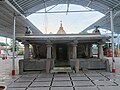 Shree Mahadevaswamy Temple
 -
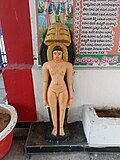 Idol of 1st Thirthankara Rishabhanatha inside Shree Mahadevaswamy Temple
 -
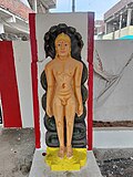 Idol of 23rd Thirthankara Parshvanath
 -
 Korutla Buruju 1
 -
 Korutla Buruju in ruining stage
 -
 Flowers carving on the walls of one of the Burujulu
 -
 A katar (Push Dagger) weapon was found in Korutla's Shree Mahadevaswamy Temple


References[edit | edit source]
- ↑ "Urban Local Body Information" (PDF). Directorate of Town and Country Planning. Government of Telangana. Archived from the original (PDF) on 15 June 2016. Retrieved 28 June 2016.
- ↑ 2.0 2.1 "Maps, Weather, and Airports for Koratla, India". fallingrain.com.
- ↑ "Basic information of municipity". Official Site of Korutla Municipality.
- ↑ India Today Web Desk. "Indian states with highest population".
- ↑ "District Administration – Formation/Reorganization of District, Revenue Divisions and Mandals in Jagtial district – Final Notification - Orders – Issued" (PDF). Jagtial District. Retrieved 25 July 2017.
- ↑ Assembly Elections 2018. "Koratla Election Result".
{{cite web}}: CS1 maint: numeric names: authors list (link) - ↑ "District Census Handbook – Karimnagar" (PDF). Census of India. pp. 12, 50. Retrieved 9 June 2016.
- ↑ "Page Redirection". data.gov.in. 21 January 2022.
- ↑ "Census tables | Government of India". censusindia.gov.in. Retrieved 29 December 2024.
- ↑ "Census of India 2001: Data from the 2001 Census, including cities, villages and towns (Provisional)". Census Commission of India. Archived from the original on 16 June 2004. Retrieved 1 November 2008.