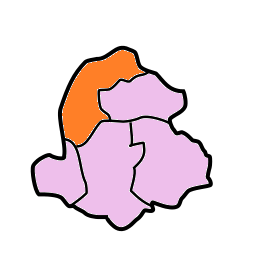
'''West Jaintia Hills''' (Pron: ˈʤeɪnˌtɪə) is an administrative [[District]] in the state of [[Meghalaya]] in [[India]]. The united district (Jaintia Hills District) was created on 22 February 1972 and occupied an [[area]] of 3819 km<sup>2</sup>. It had a [[population]] of 270,352 (as of 2011). The district is part of the [[Meghalaya subtropical forests]] ecoregion. With the bifurcation of the erstwhile Jaintia Hills District into East and West Jaintia Hills Districts, West Jaintia Hills District came into existence on 31 July 2012 with its headquarters at [[Jowai]]. Jowai is the host of all the heads of important governmental offices and establishments, educational institutions, hospitals, banking institutions, etc.<ref>{{Cite web|title=About District {{!}} West Jaintia Hills District {{!}} India|url=https://westjaintiahills.gov.in/about-district/|access-date=2020-07-14|language=en-US}}</ref>
'''West Jaintia Hills district''' (Pron: ˈʤeɪnˌtɪə) is an administrative [[District]] in the state of [[Meghalaya]] in [[India]]. The united district (Jaintia Hills District) was created on 22 February 1972 and occupied an [[area]] of 3819 km<sup>2</sup>. It had a [[population]] of 272,185 (as of 2011). The district is part of the [[Meghalaya subtropical forests]] eco-region. With the bifurcation of the erstwhile Jaintia Hills District into East and West Jaintia Hills Districts, West Jaintia Hills District came into existence on 31 July 2012 with its headquarters at [[Jowai]]. Jowai is the host of all the heads of important governmental offices and establishments, educational institutions, hospitals, banking institutions, etc.<ref>{{Cite web|title=About District {{!}} West Jaintia Hills District {{!}} India|url=https://westjaintiahills.gov.in/about-district/|access-date=2020-07-14|language=en-US}}</ref>
==Geography==
==Geography==
The total area of the district is 1693 km<sup>2</sup>. The district comprises one Civil Sub-Division Viz. Amlarem Civil Sub-Division and three Community and Rural Development Blocks viz. Amlarem C&RD Block, Laskein C&RD Block and Thadlaskein C&RD Block with the following boundaries:
The total area of the district is 1693 km<sup>2</sup>. The district comprises one Civil Sub-Division Viz. Amlarem Civil Sub-Division and four Community and Rural Development (C&RD) Blocks viz. Amlarem C&RD Block, Laskein C&RD Block, Thadlaskein C&RD Block and Namdong C&RD Block with the following boundaries:
* North – Assam
* North – Assam
Line 64:
Line 74:
==Economy==
==Economy==
[[File:Cement Plant MCL.jpg|thumb|240px| View of MCL Cement plant, Lumshnong, East Jaintia Hills]]
[[File:Cement Plant MCL.jpg|thumb|240px| View of MCL Cement plant, Lumshnong, East Jaintia Hills]]
Although the mainstay of the district is agriculture, however, due to the abundance of [[Limestone]], plenty of Cement factories have been set up in the district (now East Jaintia Hills). More are set to come up. Coal mining at sites like [[Lad Rymbai]] ([[East Jaintia Hills district]]) is also one of the major activities. Coal mined here is mostly exported to [[Bangladesh]] and [[Assam]]. Most of the coal mining sites are now situated in the East Jaintia Hills district.
Although the mainstay of the district is agriculture, due to the abundance of [[limestone]], plenty of cement factories have been set up in the district (now East Jaintia Hills). Coal mining at sites like [[Lad Rymbai]] ([[East Jaintia Hills district]]) is also one of the major activities. Most of the coal mining sites are now situated in the East Jaintia Hills district.
===Agriculture===
[[Lakadong turmeric|Lakadong Turmeric]] is a type of turmeric variety found in the West Jaintia hills district. It is one of the world’s finest turmeric varieties with the highest curcumin content of 7-9 % in comparison to 3% or less in other turmeric varieties. It has been identified under the One District, One Product (ODOP) initiative of Indian government. The State of Meghalaya has also applied for a Geographical Indication tag for it.<ref>{{Cite news|url=https://theprint.in/ani-press-releases/centres-one-district-one-product-mission-gets-technology-boost-in-meghalaya/822541/?amp|title=Centre's 'one district one product' mission gets technology boost in Meghalaya|access-date=27 February 2022}}</ref>
==Divisions==
==Divisions==
===Administrative divisions===
===Administrative divisions===
United Jaintia Hills district was divided into five blocks. With the bifurcation of the erstwhile district, West Jaintia Hills is divided into three blocks:<ref>{{cite map |publisher=The Registrar General & Census Commissioner, India, New Delhi, Ministry of Home Affairs, Government of India |title=Meghalaya Administrative Divisions |url=http://censusindia.gov.in/2011census/maps/administrative_maps/MEGHALAYA.pdf |trans-title=|language=English |format=PDF |edition= |year=2011 |cartography= |scale= |series= |page= |section= |inset= |accessdate=2011-09-29 |isbn= |id= |ref= }}</ref>
United Jaintia Hills district was divided into five blocks. With the bifurcation of the erstwhile district, West Jaintia Hills is divided into three blocks:<ref>{{cite map |publisher=The Registrar General & Census Commissioner, India, New Delhi, Ministry of Home Affairs, Government of India |title=Meghalaya Administrative Divisions |url=http://censusindia.gov.in/2011census/maps/administrative_maps/MEGHALAYA.pdf |trans-title=|language=English |format=PDF |edition= |year=2011 |cartography= |scale= |series= |page= |section= |inset= |accessdate=2011-09-29 |isbn= |id= }}</ref>
Since it is land locked region and lack of railways and airport, the only means of transportation is roadways. The main highway which runs through the district is [[NH 40]] and [[NH 44]].
Since it is a land locked region and lacks railways and an airport, the only means of transportation is roadways. The main highway which runs through the district is [[National Highway 6 (India)|NH 6]].
==Demographics==
==Demographics==
The district has a total population of 270,352, of which 134,406 are males and 135,946 are females. The density of population is 159.69 per km<sup>2</sup>.
The district has a total population of 272,185, of which 134,406 are males and 135,946 are females. The density of population is 159.69 per km<sup>2</sup>. Scheduled Tribes are 257,941 which is 94.76% of the population.<ref>{{Cite web|date=2011|title=District Census Meghalaya - Jaintia Hills|url=https://censusindia.gov.in/2011census/dchb/DCHB_A/17/1707_PART_A_DCHB_JAINTIA%20HILLS.pdf|website=censusindia.gov.in|publisher=Office of the Registrar General & Census Commissioner, India}}</ref>
{{Bar box
|float=left
|title=Religion in West Jaintia Hills (2011)<ref>{{Cite web|date=2011|title=Population by Religion - Meghalaya|url=https://censusindia.gov.in/2011census/C-01/DDW17C-01%20MDDS.XLS|website=censusindia.gov.in|publisher=Office of the Registrar General & Census Commissioner, India}}</ref>
|titlebar=#Fcd116
|left1='''Religions'''
|bars=
{{bar percent|[[Christianity in Meghalaya|Christians]]|dodgerblue|67.12}}
{{bar percent|Others*|chartreuse|28.40}}
{{bar percent|[[Hinduism in Meghalaya|Hindus]]|orange|3.50}}
{{bar percent|Other or not stated|black|0.98}}
|caption=*<small>Animists and [[Tribal religions in India|ethnic religions]]</small>
}}
===Languages===
===Languages===
The common dialect in West Jaintia hills is Pnar, belonging to the Khasian language. Other dialects include Khynriam in the western part of district, War speaking to the southern part of the district and Biate, spoken by approximately 20,000 members. The Biates also resides in the Saipung elaka in [[East Jaintia Hills district]].
{{Pie chart
|caption = Languages of West Jaintia Hills district (2011)
At the time of the 2011 census, 78.17% of the population spoke [[Pnar language|Pnar]], 12.55% [[War language|War]] and 6.64% [[Khasi language|Khasi]] as their first language.<ref>[http://www.censusindia.gov.in/2011census/C-16.html 2011 Census of India, Population By Mother Tongue]</ref>
The common dialect in West Jaintia hills is Pnar, closely related to Khasi. Other dialects include Khynriam in the western part of district and War in the southern part of the district.
==Culture==
==Culture==
===Places of interest===
===Places of interest===
The places of interest in Jaintia hills include the below:
The places of interest in Jaintia hills include the below:
*'''Monolith in Nartiang'''<ref>{{cite news|url=http://www.merinews.com/article/worlds-tallest-monoliths-in-jaintia-hills/15711193.shtml|title=Tallest Monolith|date=2009-02-17|website=Merinews.com|accessdate=18 October 2017}}</ref> - Touted as the tallest monolith in the world.
*[[Nartiang Durga Temple]] is a 600-year-old temple located in the West Jaintia Hills district of Meghalaya in northeastern India.<ref name=":0">{{Cite web|last=Talukdar|first=Prasanta|date=2020-09-12|title=History lessons from Nartiang|url=https://theshillongtimes.com/2020/09/13/history-lessons-from-nartiang/|access-date=2022-01-18|website=The Shillong Times|language=en-US}}</ref> It is one of the 51 Shakta pithas and is one of the holiest sites for devotees of the Shaktism sect of Hinduism.
*'''Jowai''': Jowai, the headquarters of the West Jaintia Hills district is situated 64 km from the national highway. A town circled by the Myntdu River.
*'''Monoliths in Nartiang''' - The garden of monoliths features a collection of large monoliths that were erected as monuments for the old Jaintia kings.
*'''[[Thadlaskein Lake]]''': 56 km from Shillong. According to legend this lake was dug with the ends of bows by members of 290 clans of U Sajar Niangli, a rebel general of Jaintia Raja, to commemorate the great exodus of the clans.
*[[File:Nartiang Monoliths in Meghalaya are tallest in the world.jpg|thumb|Nartiang Monoliths.]]'''Megalithic Remnants - Nartiang''': Nartiang was the summer capital of the Jaintia Kings, of Sutnga State. Huge monoliths, form a landmark in the village. The Nartiang menhir measures 27 feet 6 inches in thickness.
*'''Megalithic Remnants- Nartiang''': 65 km from Shillong, was the summer capital of the Jaintia Kings, of Sutnga State. Huge monoliths, form a landmark in the village. The Nartiang menhir measures 27 feet 6 inches in thickness.
*'''[[Thadlaskein Lake]]''': According to legend, this lake was dug with the ends of bows by members of 290 clans of U Sajar Niangli, a rebel general of Jaintia king, to commemorate the great exodus of the clans.
*'''Tyrshi Falls''': located at about 8 km from the Jowai.
* '''Ialong Park''': An ecological park with a view of the Pynthor Wah valley and the [[Myntdu_River|Myntdu river]].
* '''Jowai Presbyterian Church'''
*'''Syntu Ksiar''': Syntu Ksiar, which means 'golden flower' is a vast pool of calm water, where the river Myntdu which almost encircles Jowai, appears to come to a sudden halt. A valley well irrigated by the Myntdu River. Also called "Madan Madiah" or "Uncle's Ground," it is situated in the valley and has historical importance as the site of the freedom struggle's rise. Today, the ground has a monument of U Kiang Nangbah, a fighter of the Khasi people.
*'''Phe Phe Falls''': a two-tiered, secluded waterfall in the lush hills, renowned for its refreshing, clear blue plunge pool at the base where visitors can swim after a moderate trek through the scenic trail
* '''Thlu Amwi Falls'''
*'''Krangshuri Falls''': A tourist spot in Amlarem Sub-Division (War-Jaintia)
*'''Syndai''': An important village of West Jaintia Hills which is famous for a number of caves and caverns in the limestone-borne area, used as hide-outs during war times between Jaintia Hills and foreign intruders.
*'''Syndai''': An important village of West Jaintia Hills which is famous for a number of caves and caverns in the limestone-borne area, used as hide-outs during war times between Jaintia Hills and foreign intruders.
*'''Syntu Ksiar''': Syntu Ksiar, which means 'golden flower' is a vast pool of calm water, where the river Myntdu which almost encircles Jowai, appears to come to a sudden halt.
*'''Kudengrim''': known for wilderness, waterfalls, living root bridge, nature trails and more
*'''Krangshuri Falls''': A tourist spot in Amlarem Sub-Division (War-Jaintia)
*[[Dawki|Dawki - Shnongpdeng]]: border town known for nature, swimming, fishing and camping
==Education==
==Education==
Although West Jaintia Hills is not known as an education hub. Good schools and colleges do exist in Jowai, Khliehriat and [[Nongtalang]]. Prominent Colleges in West Jaintia hills include [[Jowai Polytechnic]] which is an AICTE recognised college and the only Nursing School in the district is [[Dr. Norman Tunnel Hospital School Of Nursing]] , there are other colleges too namely [[Thomas Jones Synod College]], [[Nongtalang College]] and [[Kiang Nangbah Government College|Kiang Nangbah Govt. College]] [[Jowai]] which offers degree courses in arts and science.
Although West Jaintia Hills is not known as an education hub, good{{Clarify|reason=subjective word - prestigious/large/advanced could be used|date=January 2025}} schools and colleges do exist in Jowai, Khliehriat and [[Nongtalang]]. Prominent Colleges in West Jaintia hills includes [[Jowai Polytechnic]] which is an AICTE recognised college, the [[Northeast Adventist University|North East Adventist University]] (previously known as Assam Training School) and the only Nursing School in the district is Dr. Norman Tunnel Hospital School Of Nursing. There are other colleges too namely [[Thomas Jones Synod College]], [[Nongtalang College]] and [[Kiang Nangbah Government College|Kiang Nangbah Govt. College]] [[Jowai]] which offers degree courses in arts and science. Jowai has good schools too for Secondary and Higher Secondary level, some of the well known schools in Jowai are [[K.J.P Synod Mihngi Higher Secondary School]], [[St Mary Mazzarello Girls Higher Secondary School]], [[North Liberty Higher Secondary School]] etc.
Jowai has good schools too for Secondary and Higher Secondary level , some of the well known schools in Jowai are [[K.J.P Synod Mihngi Higher Secondary School]] , [[St Mary Mazzarello Girls Higher Secondary School]] , [[North Liberty Higher Secondary School]] etc .
==See also==
==See also==
Line 136:
Line 178:
[[Category:West Jaintia Hills district| ]]
[[Category:West Jaintia Hills district| ]]
[[Category:Districts of Meghalaya]]
[[Category:Districts of Meghalaya]]
[[Category:Autonomous regions of India]]
[[Category:Autonomous administrative divisions of India]]
West Jaintia Hills district (Pron: ˈʤeɪnˌtɪə) is an administrative District in the state of Meghalaya in India. The united district (Jaintia Hills District) was created on 22 February 1972 and occupied an area of 3819 km2. It had a population of 272,185 (as of 2011). The district is part of the Meghalaya subtropical forests eco-region. With the bifurcation of the erstwhile Jaintia Hills District into East and West Jaintia Hills Districts, West Jaintia Hills District came into existence on 31 July 2012 with its headquarters at Jowai. Jowai is the host of all the heads of important governmental offices and establishments, educational institutions, hospitals, banking institutions, etc.[1]
The total area of the district is 1693 km2. The district comprises one Civil Sub-Division Viz. Amlarem Civil Sub-Division and four Community and Rural Development (C&RD) Blocks viz. Amlarem C&RD Block, Laskein C&RD Block, Thadlaskein C&RD Block and Namdong C&RD Block with the following boundaries:
North – Assam
South – Bangladesh and East Jaintia Hills district
View of MCL Cement plant, Lumshnong, East Jaintia Hills
Although the mainstay of the district is agriculture, due to the abundance of limestone, plenty of cement factories have been set up in the district (now East Jaintia Hills). Coal mining at sites like Lad Rymbai (East Jaintia Hills district) is also one of the major activities. Most of the coal mining sites are now situated in the East Jaintia Hills district.
Lakadong Turmeric is a type of turmeric variety found in the West Jaintia hills district. It is one of the world’s finest turmeric varieties with the highest curcumin content of 7-9 % in comparison to 3% or less in other turmeric varieties. It has been identified under the One District, One Product (ODOP) initiative of Indian government. The State of Meghalaya has also applied for a Geographical Indication tag for it.[2]
United Jaintia Hills district was divided into five blocks. With the bifurcation of the erstwhile district, West Jaintia Hills is divided into three blocks:[3]
Since it is a land locked region and lacks railways and an airport, the only means of transportation is roadways. The main highway which runs through the district is NH 6.
The district has a total population of 272,185, of which 134,406 are males and 135,946 are females. The density of population is 159.69 per km2. Scheduled Tribes are 257,941 which is 94.76% of the population.[4]
At the time of the 2011 census, 78.17% of the population spoke Pnar, 12.55% War and 6.64% Khasi as their first language.[6]
The common dialect in West Jaintia hills is Pnar, closely related to Khasi. Other dialects include Khynriam in the western part of district and War in the southern part of the district.
The places of interest in Jaintia hills include the below:
Nartiang Durga Temple is a 600-year-old temple located in the West Jaintia Hills district of Meghalaya in northeastern India.[7] It is one of the 51 Shakta pithas and is one of the holiest sites for devotees of the Shaktism sect of Hinduism.
Monoliths in Nartiang - The garden of monoliths features a collection of large monoliths that were erected as monuments for the old Jaintia kings.
Nartiang Monoliths.Megalithic Remnants - Nartiang: Nartiang was the summer capital of the Jaintia Kings, of Sutnga State. Huge monoliths, form a landmark in the village. The Nartiang menhir measures 27 feet 6 inches in thickness.
Thadlaskein Lake: According to legend, this lake was dug with the ends of bows by members of 290 clans of U Sajar Niangli, a rebel general of Jaintia king, to commemorate the great exodus of the clans.
Tyrshi Falls: located at about 8 km from the Jowai.
Ialong Park: An ecological park with a view of the Pynthor Wah valley and the Myntdu river.
Jowai Presbyterian Church
Syntu Ksiar: Syntu Ksiar, which means 'golden flower' is a vast pool of calm water, where the river Myntdu which almost encircles Jowai, appears to come to a sudden halt. A valley well irrigated by the Myntdu River. Also called "Madan Madiah" or "Uncle's Ground," it is situated in the valley and has historical importance as the site of the freedom struggle's rise. Today, the ground has a monument of U Kiang Nangbah, a fighter of the Khasi people.
Phe Phe Falls: a two-tiered, secluded waterfall in the lush hills, renowned for its refreshing, clear blue plunge pool at the base where visitors can swim after a moderate trek through the scenic trail
Thlu Amwi Falls
Krangshuri Falls: A tourist spot in Amlarem Sub-Division (War-Jaintia)
Syndai: An important village of West Jaintia Hills which is famous for a number of caves and caverns in the limestone-borne area, used as hide-outs during war times between Jaintia Hills and foreign intruders.
Kudengrim: known for wilderness, waterfalls, living root bridge, nature trails and more
Dawki - Shnongpdeng: border town known for nature, swimming, fishing and camping
↑Meghalaya Administrative Divisions(PDF) (Map). The Registrar General & Census Commissioner, India, New Delhi, Ministry of Home Affairs, Government of India. 2011. Retrieved 29 September 2011.




.jpg)






