


>GünniX m v2.04 - Fix errors for CW project (Square brackets without correct beginning) |
WikiDwarfBOT (talk | contribs) Cleanup: Source modification. |
||
| (One intermediate revision by one other user not shown) | |||
| Line 2: | Line 2: | ||
{{Use Indian English|date=February 2017}} | {{Use Indian English|date=February 2017}} | ||
{{Use dmy dates|date=February 2017}} | {{Use dmy dates|date=February 2017}} | ||
<!-- See [[Wikipedia:WikiProject Indian cities]] for details --> | <!-- See [[Wikipedia:WikiProject Indian cities]] for details --> | ||
{{Infobox settlement | {{Infobox settlement | ||
| Line 11: | Line 10: | ||
| nickname = | | nickname = | ||
| settlement_type = Town | | settlement_type = Town | ||
| image_skyline | | image_skyline = {{multiple image | ||
| border = infobox | |||
| total_width = 280 | |||
| image_style = | |||
| perrow = 1/1/1 | |||
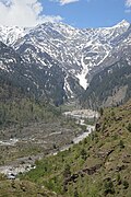
| image1 =Beas Valley - Palchan - Kullu 2014-05-10 2275.JPG | |||
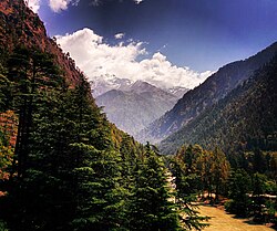
| image2= Beas River, Kullu Valley.jpg | |||
| image3= Kullu Valley with River Beas - Kullu - Himachal Pradesh - 2014-05-09 2186.JPG | |||
}} | |||
| image_alt = | | image_alt = | ||
| image_caption = Kullu | | image_caption = Kullu Valley, Beas River | ||
| pushpin_map = India Himachal Pradesh#India | | pushpin_map = India Himachal Pradesh#India | ||
| pushpin_label_position = | | pushpin_label_position = | ||
| pushpin_map_alt = | | pushpin_map_alt = | ||
| pushpin_map_caption = Location in Himachal Pradesh, India | | pushpin_map_caption = Location in Himachal Pradesh, India | ||
| coordinates = {{coord|31. | | coordinates = {{coord|31.95|77.11|display=title,inline}} | ||
| subdivision_type = Country | | subdivision_type = Country | ||
| subdivision_name = {{flag|India}} | | subdivision_name = {{flag|India}} | ||
| subdivision_type1 = [[States and territories of India|State]] | | subdivision_type1 = [[States and territories of India|State]] | ||
| subdivision_name1 = {{flagicon image| | | subdivision_name1 = {{flagicon image|}} [[Himachal Pradesh]] | ||
| subdivision_type2 = [[List of districts of India|District]] | | subdivision_type2 = [[List of districts of India|District]] | ||
| subdivision_name2 = [[Kullu District|Kullu]] | | subdivision_name2 = [[Kullu District|Kullu]] | ||
| Line 41: | Line 48: | ||
| population_total = 18,536 | | population_total = 18,536 | ||
| population_as_of = 2011 | | population_as_of = 2011 | ||
| population_rank = [[List of cities in Himachal Pradesh by population| | | population_rank = [[List of cities in Himachal Pradesh by population|11th in HP]] | ||
| population_density_km2 = auto | | population_density_km2 = auto | ||
| population_demonym = | | population_demonym = | ||
| Line 54: | Line 61: | ||
| area_code_type = Telephone code | | area_code_type = Telephone code | ||
| area_code = 01902 | | area_code = 01902 | ||
| registration_plate = | | registration_plate = '''HP-34, HP-35, HP-49, HP-58, HP-66''' | ||
| blank1_name_sec1 = [[Human sex ratio|Sex ratio]] | | blank1_name_sec1 = [[Human sex ratio|Sex ratio]] | ||
| blank1_info_sec1 = 1.17 (1000/852) [[male|♂]]/[[female|♀]] | | blank1_info_sec1 = 1.17 (1000/852) [[male|♂]]/[[female|♀]] | ||
| website = [http://www.hpkullu. | | website = [http://www.hpkullu.nic.in www.hpkullu.nic.in] | ||
| footnotes = | | footnotes = | ||
}} | }} | ||
'''Kullu''' is a [[municipal council]] town that serves as the administrative headquarters of the [[Kullu district]] of the [[states and union territories of India|Indian state]] of [[Himachal Pradesh]]. It is located on the banks of the [[Beas River]] in the [[ | '''Kullu''' is a [[municipal council]] town that serves as the administrative headquarters of the [[Kullu district]] of the [[states and union territories of India|Indian state]] of [[Himachal Pradesh]]. It is located on the banks of the [[Beas River]] in the [[Kullu Valley]] about {{convert|10|km}} north of the airport at [[Bhuntar|Bhuntar, Kullu]]. | ||
[[Kullu Valley]] is a broad open [[valley]] formed by the [[Beas River]] between [[Manali, Himachal Pradesh|Manali]] and | [[Kullu Valley]] is a broad open [[valley]] formed by the [[Beas River]] between [[Manali, Himachal Pradesh|Manali]] and Larji. This valley is known for its temples and its hills covered with [[pine]] and [[Cedrus deodara|deodar]] forest and sprawling apple orchards. The course of the Beas river, originating from Beas Kund<ref>{{Cite book|last=Jutta.|first=Mattausch|url=http://worldcat.org/oclc/964402368|title=Reise Know-How Ladakh und Zanskar|date=2016|publisher=Reise Know-How Verlag Peter Rump|isbn=978-3-8317-4694-1|oclc=964402368}}</ref> presents a succession of hillside settlements studded amongst forests of deodar that tower above pine trees on the lower rocky ridges. Together with the river Beas running through the valley, the town of Kullu offers truly magnificent views. Kullu Valley is sandwiched between the [[Pir Panjal Range|Pir Panjal]], Lower Himalayan and [[Great Himalayas|Great Himalayan Ranges]], located in Northern India, 497 k.m. away from the capital of India. | ||
==History== | ==History== | ||
Historical references about the Kullu valley dates back to ancient Hindu literary works of [[Ramayana]], [[Mahabharata]] and the [[Puranas]].<ref>http://himachal.gov.in/index1.php?lang=1&dpt_id=200&level=1&lid=8449&sublinkid=8216</ref> During Vedic period several small republics known as "[[Janapada]]" existed which were later conquered by the [[Nanda Empire]], [[Mauryan Empire]], [[Gupta Empire]], [[Pala Dynasty]] and [[Karkoṭa Empire]]. After a brief period of supremacy by King [[Harshavardhana]], the region was once again divided into several local powers headed by chieftains, including some [[Rajput]] principalities, these principalities were later conquered by [[Maratha Empire]] | Historical references about the Kullu valley dates back to ancient Hindu literary works of [[Ramayana]], [[Mahabharata]] and the [[Puranas]].<ref>http://himachal.gov.in/index1.php?lang=1&dpt_id=200&level=1&lid=8449&sublinkid=8216 {{Bare URL inline|date=August 2022}}</ref> During Vedic period several small republics known as "[[Janapada]]" existed which were later conquered by the [[Nanda Empire]], [[Mauryan Empire]], [[Shunga Empire]], [[Gupta Empire]], [[Pala Dynasty]] and [[Karkoṭa Empire]]. After a brief period of supremacy by King [[Harshavardhana]], the region was once again divided into several local powers headed by chieftains, including some [[Rajput]] principalities, these principalities were later conquered by [[Mughal Empire]], [[Maratha Empire]], [[Sikh Empire]].{{sfn|Verma|1995|pp = 28–35, ''Historical Perspective''}} | ||
The name Kullu derives from the word "Kulant Peeth", meaning "end of the habitable world". As per legends, during the Great Flood, Manu visited this valley but was unable to cross the Rohtang pass. He named the last settlement he found as Kulant Peeth and chose to settle and meditate in what has now become the town of Manali (Manu's Place). The name further devolved into "[https://books.google.com/books?id=sjSiPRXZwscC | The name Kullu derives from the word "Kulant Peeth", meaning "end of the habitable world". As per legends, during the Great Flood, [[Manusmriti|Manu]] visited this valley but was unable to cross the Rohtang pass. He named the last settlement he found as Kulant Peeth and chose to settle and meditate in what has now become the town of Manali (Manu's Place). The name further devolved into "[https://books.google.com/books?id=sjSiPRXZwscC&dq=kulut+kullu&pg=PA28 Kulut]", as the kingdom was known for a long time; before finally being known by the current name of Kullu or Kulu. | ||
The [[Buddhism|Buddhist]] pilgrim monk [[Xuanzang]] visited the Kullu Valley in 634 or 635 CE. He described it as a fertile region completely surrounded by mountains, about 3,000 ''li'' in circuit, with a capital 14 or 15 ''li'' in circumference | The [[Buddhism|Buddhist]] pilgrim monk [[Xuanzang]] visited the Kullu Valley in 634 or 635 CE. He described it as a fertile region completely surrounded by mountains, about 3,000 ''li'' in circuit, with a capital 14 or 15 ''li'' in circumference. There were some twenty Buddhist monasteries, with about 1,000 monks, most of whom were [[Mahayanist]]. There were also some fifteen Hindu temples, and both faiths occupied the region. There were meditation caves near the mountain passes inhabited by both Buddhist and Hindus. The country is said to have produced gold, silver, red copper, crystal lenses and bell-metal.<ref>Watters (1904-1905), pp. 298, 335.</ref> | ||
Kullu got its first motorable access only after [[Partition of India|Indian Independence]]. The long centuries of seclusion have, however, allowed the area to retain a considerable measure of its traditional charm. The road through the Kullu Valley and [[Lahaul]] is now paved all the way, to connect and provide the major access route between the northern Indian plains to [[Leh]] in [[Ladakh]]. | Kullu got its first motorable access only after [[Partition of India|Indian Independence]]. The long centuries of seclusion have, however, allowed the area to retain a considerable measure of its traditional charm. The road through the Kullu Valley and [[Lahaul]] is now paved all the way, to connect and provide the major access route between the northern Indian plains to [[Leh]] in [[Ladakh]]. | ||
| Line 77: | Line 84: | ||
== Geography == | == Geography == | ||
[[File:Beas Valley - Palchan - Kullu 2014-05-10 2275.JPG|thumb|260px|right|Kullu town lies on the bank of [[Beas River]].]] | [[File:Beas Valley - Palchan - Kullu 2014-05-10 2275.JPG|thumb|260px|right|Kullu town lies on the bank of [[Beas River]].]] | ||
Kullu town has an average elevation of {{convert|1278|m|ft|abbr=on}}. It lies on the bank of [[Beas River]]. A major tributary, Sarvari, (derived from "Shiv-Baardi") leads to the less explored and steeper Lug-valley on the west. On the east of Kullu lies a broad mountainous ridge having the village-temples of [[Bijli Mahadev]], | Kullu town has an average elevation of {{convert|1278|m|ft|abbr=on}}. It lies on the bank of [[Beas River]]. A major tributary, Sarvari, (derived from "Shiv-Baardi") leads to the less explored and steeper Lug-valley on the west. On the east of Kullu lies a broad mountainous ridge having the village-temples of [[Bijli Mahadev]], Anant Nag and Peej. Beyond the ridge lies Manikaran valley, along the Parvati river which joins Beas at in Bhuntar. On the south of Kullu lie the towns of Bhuntar and Aut, leading to Anni, Banjar, the Sainj Valley) and Mandi (in Mandi district). Historically Kullu was accessible from Shimla via the Sainj valley, or through passes on the west leading to Jogindernagar and onto the district of Kangra. 40 km. north lies the rather famous town of Manali. A few hours of a very winding car ride on the main highway leads to Rohtang Pass and the source of the Beas river, at 13,500 ft, 4110 m. The same road continues on to the Lahaul and Spiti Valley(now also accessible by Atal tunnel). One can see an enormous change in the climate as one climbs up the windward side of the ranges to proceed to the leeward and much drier plateaus to the north of Manali. Lahaul and Spiti are inhabited mostly by Tibetan descendants, and have entirely different customs, food, clothing, and culture than the rest of India. | ||
The valley has varied biodiversity | The valley has varied biodiversity. It has some of the rarest of animals like the [[Himalayan tahr]], [[western tragopan]], [[monal]], [[Himalayan brown bear]] and the snow leopard. The Great Himalayan National Park (GHNP) is also located here (near Banjar). The park was built in 1984. It spreads over an area of {{convert|1,171|km2|abbr=on}} which lies between an altitude of {{convert|1500| to| 6000 |m| ft|abbr=on}}. In order to protect the flora and fauna of this Himalayan area, many places are declared as wildlife sanctuaries, such as: Khokhan Sanctuary, Kais Sanctuary, Tirthan Sanctuary, Kanawar Sanctuary, Rupi Baba Sanctuary, Great Himalayan National Park and Van Vihar Manali. | ||
[[File:Kullu Valley in autumn, Himachal Pradesh.jpg|thumb|160px|Autumn in Kullu Valley]] | [[File:Kullu Valley in autumn, Himachal Pradesh.jpg|thumb|160px|Autumn in Kullu Valley]] | ||
The temperature in | The temperature in Kullu valley in summer season is about 20 to 30 degree C. December and January during winter observe lowest temperatures ranging from {{convert|-4|to|20|C}}, with heavy snowfall in the higher regions and very light snowfall in the main town, though the frequency is declining. Evenings and mornings are cold during winters. Annual highest temperature in summer ranges from {{convert|24|to|34|C}} during May to August. Months of July and August are rainy because of monsoon, having around {{convert|150|mm|abbr=on}} rainfall monthly. Climate is pleasant in October and November. | ||
== Demographics == | == Demographics == | ||
{{As of|2011}} India [[census]],<ref>{{cite web|url=http://www.censusindia.net/results/town.php?stad=A&state5=999|archive-url=https://web.archive.org/web/20040616075334/http://www.censusindia.net/results/town.php?stad=A&state5=999|archive-date=2004-06-16|title= Census of India 2001: Data from the 2001 Census, including cities, villages and towns (Provisional)|access-date=2008-11-01|publisher= Census Commission of India}}</ref> Kullu had a population of 437,903. Males in | {{As of|2011}} India [[census]],<ref>{{cite web|url=http://www.censusindia.net/results/town.php?stad=A&state5=999|archive-url=https://web.archive.org/web/20040616075334/http://www.censusindia.net/results/town.php?stad=A&state5=999|archive-date=2004-06-16|title= Census of India 2001: Data from the 2001 Census, including cities, villages and towns (Provisional)|access-date=2008-11-01|publisher= Census Commission of India}}</ref> Kullu had a population of 437,903. Males in Kullu are 225,452 whereas females are 212,451. Sex ratio of Kullu is 942 females per 1000 males which is higher than national sex ratio . The average literacy rate of Kullu is 79.40% whereas male literacy rate is 87.39% and female literacy rate is 70.91%. The people speak the [[Kullui]] language. | ||
==Administrative== | ==Administrative== | ||
Kullu town, as the administrative headquarters of Kullu district, has the offices of Deputy Commissioner, the Superintendent of Police and the District courts. It is also the largest and the most varied constituency of [[Lok Sabha]], the lower house of the parliament of India. | Kullu town, as the administrative headquarters of Kullu district, has the offices of Deputy Commissioner, the Superintendent of Police and the District courts. It is also the largest and the most varied constituency of [[Lok Sabha]], the lower house of the parliament of India. Kullu administration was transferred from '''Sultan Pur''' (former [[Capital city|capital]]) to present Kullu town. | ||
== Transport == | == Transport == | ||
===Air=== | ===Air=== | ||
The nearest airport (IATA code KUU) is at Bhuntar town, situated on NH21 at the confluence of the Parvati and Beas rivers (latitude 31.8763 N and longitude 77.1541 E), about {{convert|10|km|abbr=on}} south of Kullu town. The airport is also known as Kullu-Manali airport and has a runway more than a kilometre long. Indian Airlines and some private airlines have regular flights to the airport. Himalayan Bulls in collaboration with Deccan Charters started flights on Kullu-Chandigarh-Kullu sector beginning 2 April 2014 with 2 to 3 unscheduled flights each day in eight-seater planes. | The nearest airport (IATA code KUU) is at Bhuntar town, situated on NH21 at the confluence of the Parvati and Beas rivers (latitude 31.8763 N and longitude 77.1541 E), about {{convert|10|km|abbr=on}} south of Kullu town. The airport is also known as Kullu-Manali airport and has a runway more than a kilometre long. Indian Airlines and some private airlines have regular flights to the airport. Himalayan Bulls in collaboration with Deccan Charters started flights on Kullu-Chandigarh-Kullu sector beginning 2 April 2014 with 2 to 3 unscheduled flights each day in eight-seater planes. The Pane Tickets Usually has a very High price. | ||
[[Chandigarh]] airport is the nearest large airport. | [[Chandigarh]] airport is the nearest large airport. | ||
===Road=== | ===Road=== | ||
Kullu can be reached from Delhi by [[National Highway 1 (India)|national highway NH 1]] up to [[Chandigarh]] and from there by [[National Highway 21 (India)|national highway NH21]] that passes through [[Bilaspur, Himachal Pradesh|Bilaspur]], [[Sundernagar]] and [[Mandi, Himachal Pradesh, India|Mandi]] towns. The road distance from Delhi to Chandigarh by bus is {{convert|260|km|abbr=on}} and from Chandigarh to Kullu is {{convert|252|km|abbr=on}}; the total distance from Delhi to Kullu thus is about {{convert|512|km|abbr=on}}. | Kullu can be reached from Delhi by [[National Highway 1 (India)|national highway NH 1]] up to [[Chandigarh]] and from there by [[National Highway 21 (India)|national highway NH21]] that passes through [[Bilaspur, Himachal Pradesh|Bilaspur]], [[Sundernagar]] and [[Mandi, Himachal Pradesh, India|Mandi]] towns. The road distance from Delhi to Chandigarh by bus is {{convert|260|km|abbr=on}} and from Chandigarh to Kullu is {{convert|252|km|abbr=on}}; the total distance from Delhi to Kullu thus is about {{convert|512|km|abbr=on}}. It's almost a 12 hours journey. | ||
'''<big>Railways</big>''' | |||
Kullu doesn't have any Railtracks until now. But Government has surveyed the land for railway construction. It may take some time though. | |||
=== | == Economy == | ||
''See Economy section in [[Kullu district]].'' | |||
== Tourism == | |||
[[File:Beas Valley - Kothi - Kullu 2014-05-10 2295.JPG|thumb|190px|View of Himalayas from Beas river valley in Kullu.]] | |||
[[File:Parvati Valley.jpg|thumb|Parvati Valley]] | |||
[[File: | [[File:Hidimba Devi Temple with Worshippers - Manali 2014-05-11 2680-2681.TIF|thumb|The Hidimba Devi Temple also known as the Hadimba Temple]]''For places of interest, festivals, and outdoor sports in Kullu, see Attractions section in'' ''[[Kullu district]].'' | ||
==References== | ==References== | ||
| Line 172: | Line 133: | ||
== External links == | == External links == | ||
* [https://web.archive.org/web/20080629051314/http://www.kullu.tv/ News and videos of Kullu] | * [https://web.archive.org/web/20080629051314/http://www.kullu.tv/ News and videos of Kullu] | ||
* [https://web.archive.org/web/20110320012627/http://himachaltourism.gov.in/post/Kullu.aspx Himachal Tourism website] | * [https://web.archive.org/web/20110320012627/http://himachaltourism.gov.in/post/Kullu.aspx Himachal Tourism website] | ||
* [http://irmtkullu.com/ International Roerich Memorial Trust] | * [http://irmtkullu.com/ International Roerich Memorial Trust] | ||
Latest revision as of 06:40, 22 July 2023
Kullu
Kulu | |
|---|---|
Town | |
Kullu Valley, Beas River | |
  Kullu Location in Himachal Pradesh, India  Kullu Kullu (India) | |
| Coordinates: 31°57′N 77°07′E / 31.95°N 77.11°E | |
| Country |  India India |
| State |  Himachal Pradesh Himachal Pradesh |
| District | Kullu |
| Government | |
| • Type | Democratic |
| Elevation | 1,279 m (4,196 ft) |
| Population (2011) | |
| • Total | 18,536 |
| • Rank | 11th in HP |
| Languages | |
| • Official | Hindi |
| Time zone | UTC+5:30 (IST) |
| PIN | 175101 |
| Telephone code | 01902 |
| Vehicle registration | HP-34, HP-35, HP-49, HP-58, HP-66 |
| Sex ratio | 1.17 (1000/852) ♂/♀ |
| Website | www.hpkullu.nic.in |


Kullu is a municipal council town that serves as the administrative headquarters of the Kullu district of the Indian state of Himachal Pradesh. It is located on the banks of the Beas River in the Kullu Valley about 10 kilometres (6.2 mi) north of the airport at Bhuntar, Kullu.
Kullu Valley is a broad open valley formed by the Beas River between Manali and Larji. This valley is known for its temples and its hills covered with pine and deodar forest and sprawling apple orchards. The course of the Beas river, originating from Beas Kund[1] presents a succession of hillside settlements studded amongst forests of deodar that tower above pine trees on the lower rocky ridges. Together with the river Beas running through the valley, the town of Kullu offers truly magnificent views. Kullu Valley is sandwiched between the Pir Panjal, Lower Himalayan and Great Himalayan Ranges, located in Northern India, 497 k.m. away from the capital of India.
History[edit | edit source]
Historical references about the Kullu valley dates back to ancient Hindu literary works of Ramayana, Mahabharata and the Puranas.[2] During Vedic period several small republics known as "Janapada" existed which were later conquered by the Nanda Empire, Mauryan Empire, Shunga Empire, Gupta Empire, Pala Dynasty and Karkoṭa Empire. After a brief period of supremacy by King Harshavardhana, the region was once again divided into several local powers headed by chieftains, including some Rajput principalities, these principalities were later conquered by Mughal Empire, Maratha Empire, Sikh Empire.[3]
The name Kullu derives from the word "Kulant Peeth", meaning "end of the habitable world". As per legends, during the Great Flood, Manu visited this valley but was unable to cross the Rohtang pass. He named the last settlement he found as Kulant Peeth and chose to settle and meditate in what has now become the town of Manali (Manu's Place). The name further devolved into "Kulut", as the kingdom was known for a long time; before finally being known by the current name of Kullu or Kulu.
The Buddhist pilgrim monk Xuanzang visited the Kullu Valley in 634 or 635 CE. He described it as a fertile region completely surrounded by mountains, about 3,000 li in circuit, with a capital 14 or 15 li in circumference. There were some twenty Buddhist monasteries, with about 1,000 monks, most of whom were Mahayanist. There were also some fifteen Hindu temples, and both faiths occupied the region. There were meditation caves near the mountain passes inhabited by both Buddhist and Hindus. The country is said to have produced gold, silver, red copper, crystal lenses and bell-metal.[4]
Kullu got its first motorable access only after Indian Independence. The long centuries of seclusion have, however, allowed the area to retain a considerable measure of its traditional charm. The road through the Kullu Valley and Lahaul is now paved all the way, to connect and provide the major access route between the northern Indian plains to Leh in Ladakh.
Geography[edit | edit source]

Kullu town has an average elevation of 1,278 m (4,193 ft). It lies on the bank of Beas River. A major tributary, Sarvari, (derived from "Shiv-Baardi") leads to the less explored and steeper Lug-valley on the west. On the east of Kullu lies a broad mountainous ridge having the village-temples of Bijli Mahadev, Anant Nag and Peej. Beyond the ridge lies Manikaran valley, along the Parvati river which joins Beas at in Bhuntar. On the south of Kullu lie the towns of Bhuntar and Aut, leading to Anni, Banjar, the Sainj Valley) and Mandi (in Mandi district). Historically Kullu was accessible from Shimla via the Sainj valley, or through passes on the west leading to Jogindernagar and onto the district of Kangra. 40 km. north lies the rather famous town of Manali. A few hours of a very winding car ride on the main highway leads to Rohtang Pass and the source of the Beas river, at 13,500 ft, 4110 m. The same road continues on to the Lahaul and Spiti Valley(now also accessible by Atal tunnel). One can see an enormous change in the climate as one climbs up the windward side of the ranges to proceed to the leeward and much drier plateaus to the north of Manali. Lahaul and Spiti are inhabited mostly by Tibetan descendants, and have entirely different customs, food, clothing, and culture than the rest of India.
The valley has varied biodiversity. It has some of the rarest of animals like the Himalayan tahr, western tragopan, monal, Himalayan brown bear and the snow leopard. The Great Himalayan National Park (GHNP) is also located here (near Banjar). The park was built in 1984. It spreads over an area of 1,171 km2 (452 sq mi) which lies between an altitude of 1,500 to 6,000 m (4,900 to 19,700 ft). In order to protect the flora and fauna of this Himalayan area, many places are declared as wildlife sanctuaries, such as: Khokhan Sanctuary, Kais Sanctuary, Tirthan Sanctuary, Kanawar Sanctuary, Rupi Baba Sanctuary, Great Himalayan National Park and Van Vihar Manali.

The temperature in Kullu valley in summer season is about 20 to 30 degree C. December and January during winter observe lowest temperatures ranging from −4 to 20 °C (25 to 68 °F), with heavy snowfall in the higher regions and very light snowfall in the main town, though the frequency is declining. Evenings and mornings are cold during winters. Annual highest temperature in summer ranges from 24 to 34 °C (75 to 93 °F) during May to August. Months of July and August are rainy because of monsoon, having around 150 mm (5.9 in) rainfall monthly. Climate is pleasant in October and November.
Demographics[edit | edit source]
As of 2011[update] India census,[5] Kullu had a population of 437,903. Males in Kullu are 225,452 whereas females are 212,451. Sex ratio of Kullu is 942 females per 1000 males which is higher than national sex ratio . The average literacy rate of Kullu is 79.40% whereas male literacy rate is 87.39% and female literacy rate is 70.91%. The people speak the Kullui language.
Administrative[edit | edit source]
Kullu town, as the administrative headquarters of Kullu district, has the offices of Deputy Commissioner, the Superintendent of Police and the District courts. It is also the largest and the most varied constituency of Lok Sabha, the lower house of the parliament of India. Kullu administration was transferred from Sultan Pur (former capital) to present Kullu town.
Transport[edit | edit source]
Air[edit | edit source]
The nearest airport (IATA code KUU) is at Bhuntar town, situated on NH21 at the confluence of the Parvati and Beas rivers (latitude 31.8763 N and longitude 77.1541 E), about 10 km (6.2 mi) south of Kullu town. The airport is also known as Kullu-Manali airport and has a runway more than a kilometre long. Indian Airlines and some private airlines have regular flights to the airport. Himalayan Bulls in collaboration with Deccan Charters started flights on Kullu-Chandigarh-Kullu sector beginning 2 April 2014 with 2 to 3 unscheduled flights each day in eight-seater planes. The Pane Tickets Usually has a very High price.
Chandigarh airport is the nearest large airport.
Road[edit | edit source]
Kullu can be reached from Delhi by national highway NH 1 up to Chandigarh and from there by national highway NH21 that passes through Bilaspur, Sundernagar and Mandi towns. The road distance from Delhi to Chandigarh by bus is 260 km (160 mi) and from Chandigarh to Kullu is 252 km (157 mi); the total distance from Delhi to Kullu thus is about 512 km (318 mi). It's almost a 12 hours journey.
Railways
Kullu doesn't have any Railtracks until now. But Government has surveyed the land for railway construction. It may take some time though.
Economy[edit | edit source]
See Economy section in Kullu district.
Tourism[edit | edit source]


For places of interest, festivals, and outdoor sports in Kullu, see Attractions section in Kullu district.
References[edit | edit source]
- ↑ Jutta., Mattausch (2016). Reise Know-How Ladakh und Zanskar. Reise Know-How Verlag Peter Rump. ISBN 978-3-8317-4694-1. OCLC 964402368.
- ↑ http://himachal.gov.in/index1.php?lang=1&dpt_id=200&level=1&lid=8449&sublinkid=8216 [bare URL]
- ↑ Verma 1995, pp. 28–35, Historical Perspective.
- ↑ Watters (1904-1905), pp. 298, 335.
- ↑ "Census of India 2001: Data from the 2001 Census, including cities, villages and towns (Provisional)". Census Commission of India. Archived from the original on 16 June 2004. Retrieved 1 November 2008.
Further reading[edit | edit source]
- Francke, A. H. (1914, 1926). Antiquities of Indian Tibet. Two Volumes. Calcutta. 1972 reprint: S. Chand, New Delhi.
- Hutchinson, J. & J. PH Vogel (1933). History of the Panjab Hill States, Vol. II. 1st edition: Govt. Printing, Pujab, Lahore, 1933. Reprint 2000. Department of Language and Culture, Himachal Pradesh. Chapter X Kulu State, pp. 413–473.
- Watters, Thomas. (1904–1905): On Yuan Chwang’s Travels in India. 1904–1905. London. Royal Asiatic Society. Reprint: Delhi. Munshiram Manoharlal. 1973.
.png)