.svg)
National Highway 744 (India)
 Thank you for being part of the Bharatpedia family! 0% transparency: ₹0 raised out of ₹100,000 (0 supporter) |
 | ||||
|---|---|---|---|---|
| Route information | ||||
| Template:Infobox road/meta/spur of | ||||
| Maintained by NHAI | ||||
| Length | 206 km (128 mi) | |||
| History | Announced as 'NH-208' in 2000 | |||
| Major junctions | ||||
| West end | ||||
| East end | ||||
| Location | ||||
| States | Kerala, Tamil Nadu | |||
| Highway system | ||||
| ||||
National Highway 744 or NH 744 (earlier NH 208)[1] is a National Highway in Southern India that links Kollam (Quilon) in Kerala with Madurai in Tamil Nadu.[2] Starting from NH 66 at Chinnakkada in Kollam, it joins Tirumangalam in Madurai at National Highway 44 (India).[2]
Presenting the Union budget, Union Finance Minister, Nirmala Sitharaman, on Monday, announced the allocation of ₹1.03 lakh crore for upgradation of 3,500 km of highways in Tamil Nadu, including the Madurai kollam highway
Route[edit]
Chinnakada → Kallumthazham →Keralapuram → Kundara → Kottarakkara → Punalur → Thenmala → Aryankavu → Shenkottai → Tenkasi → Kadayanallur → Puliangudi → Vasudevanallur → Sivagiri → Seithur → Rajapalayam → Srivilliputtur → Tirumangalam[3]
Significance[edit]
This route has historically connected the cashew and spice producing Kollam District with the erstwhile Madras State. Nowadays, hordes of lorries carrying various goods from Tamil Nadu ply through this highway. The road cuts through the narrow low altitude gap at Aryankavu, and is a visual delight, especially the stretch from Thenmala to Sengottai. The historic Kollam-Sengottai Railway line goes by the side of the road.[4]
Four Laning[edit]
New Alignment of NH 744 Kadampattukonam - Thenamala in Kerala. As per news reports[5] and NHAI[6] tender & project data, it has been confirmed that the section of NH 744 between Tirumangalam (on NH 44) and Rajapalayam is being taken up to be converted into a tolled, four lane highway for a total distance of 68 km.
Gallery[edit]
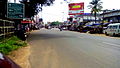
NH-744 at Kadappakada, Kollam City
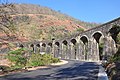
13 Ring Bridge near the side of NH 744, Thenmala

A sign board in NH 744


See also[edit]
- List of National Highways in India (by Highway Number)
- List of National Highways in India
- National Highways Development Project
References[edit]
- ↑ http://www.keralapwd.gov.in/getPage.php?page=NH%20in%20Kerala&pageId=301-title=National
- ↑ 2.0 2.1 Details of National Highways in IndiaArchived 10 April 2009 at the Library of Congress Web Archives
- ↑ Google maps
- ↑ "Government sanctions INR 3440 Cr for projects in Kerala". Devdiscourse. 9 August 2018. Retrieved 10 August 2018.
- ↑ "Maalaimalar News: திருமங்கலம்-ராஜபாளையம் வரை 68 கிலோ மீட்டர் தூரத்திற்கு 4 வழிசாலையாக மாற்றம்: பொன்.ராதாகிருஷ்ணன் || Tirumangalam Rajapalayam 68 km to the modification 4 path road ponradhakrishnan". www.maalaimalar.com. Retrieved 3 December 2016.
- ↑ "Project Reporter | Four Laning of Thirumangalam to Rajapalayam Section". Retrieved 3 December 2016.


