Poobong Tea Garden
Chota Poobong | |
|---|---|
Village | |
 | |
Poobong Tea Garden is located in West Bengal Poobong Tea Garden Location in West Bengal, India  Poobong Tea Garden Poobong Tea Garden (India) | |
| Coordinates: 26°59′55″N 88°11′39″E / 26.998634°N 88.194305°E | |
| Country | |
| State | West Bengal |
| District | Darjeeling |
| Elevation | 1,520 m (4,990 ft) |
| Population (2011) | |
| • Total | 2,170 |
| Languages | |
| • Official | Gorkhali, English |
| Time zone | UTC+5:30 (IST) |
| PIN | 734102 |
| Telephone code | 0091 354 |
| Vehicle registration | WB- |
| Coastline | 0 kilometres (0 mi) |
| Nearest city | Ghoom |
| Sex ratio | 1;1 ♂/♀ |
| Literacy | 40% |
| Avg. summer temperature | 25 °C (77 °F) |
| Avg. winter temperature | 2 °C (36 °F) |
| Website | darjeeling |
Poobong Tea Garden (also spelled Pubong) is a village in the Jorebunglow Sukhiapokhri CD block in the Darjeeling Sadar subdivision of the Darjeeling district in West Bengal, India.
Etymology[edit | edit source]
Poobong means 'a valley behind the clouds'. [1]
History[edit | edit source]
Poobong Tea Estate was established in 1913.[2]
Geography[edit | edit source]
Lua error in Module:OSM_Location_map at line 1984: attempt to index field 'wikibase' (a nil value).
Area overview[edit | edit source]
The map alongside shows a portion of the southern portion of the Darjeeling Himalayan hill region in the Darjeeling district. In the Darjeeling Sadar subdivision 61.00% of the total population lives in the rural areas and 39.00% of the population lives in the urban areas. In the Mirik subdivision 80.11% of the total population lives in rural areas and 19.89% lives in urban areas.[3][4] There are 78 tea gardens/ estates (the figure varies slightly according to different sources), in the district, producing and largely exporting Darjeeling tea. It engages a large proportion of the population directly/ indirectly.[5] Some tea gardens were identified in the 2011 census as census towns or villages.[6] Such places are marked in the map as CT (census town) or R (rural/ urban centre). Specific tea estate pages are marked TE.
Note: The map alongside presents some of the notable locations in the subdivision. All places marked in the map are linked in the larger full screen map.
Location[edit | edit source]
This section needs additional citations for verification. (March 2020) |
Poobong, situated between Sukhiapokhri and Ghoom, is so small that it is often referred to as 'Chhota Poobong'. It is 8 km from Ghoom railway station and 13 km from Darjeeling. Darjeeling tea is produced in Poobong Tea Estate at a height varying from 3,000 to 5,000 ft (910 to 1,520 m).[1]
From the main road it is around 3.5 km rough road down towards the village. The main sources of income of this place was/is working in the Tea Garden but some are engaged in agriculture and some go to work in different parts of India and abroad.
Poobong has two divisions: Tea estate and Busty. There are 4 primary schools, Chettri Goan Primary School, Poobong Kaman Primary School, Alubari Primary School and Poobong Fatak Primary School; one junior high school is in school Dara. For higher education one has to go to Ghoom, Sukhia, Darjeeling etc.
Demographics[edit | edit source]
According to the 2011 Census of India, Pubong Tea Garden had a total population of 2,170 of which 1,098 (51%) were males and 1,072 (49%) were females. There were 165 persons in the age range of 0 to 6 years. The total number of literate people in Pubong Tea Garden was 1,660 (76.50% of the population over 6 years).[7]
Gallery[edit | edit source]
-
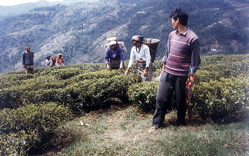
 Tea Gardan
 -
 Local House
 -


References[edit | edit source]
- ↑ 1.0 1.1 "Poobong Tea Estate". Darjeeling Tea Boutique. Retrieved 6 March 2020.
- ↑ "Poobong Tea Estate". Tea Box. Retrieved 6 March 2020.
- ↑ "Darjeeling". District Profile - General Information. District administration. Retrieved 21 March 2020.
- ↑ "District Statistical Handbook 2013 Darjeeling". Tables 2.2, 2.4b. Department of Planning and Statistics, Government of West Bengal. Archived from the original on 21 January 2019. Retrieved 21 March 2020.
- ↑ "Darjeeling Tea". District administration. Retrieved 21 March 2020.
- ↑ "2011 Census – Primary Census Abstract Data Tables". West Bengal – District-wise. Registrar General and Census Commissioner, India. Retrieved 21 March 2020.
- ↑ "2011 Census – Primary Census Abstract Data Tables". West Bengal – District-wise. Registrar General and Census Commissioner, India. Retrieved 3 March 2020.