Kamta-Rajaula State
| Kamta-Rajaula State कामता-राजुला रियासत | |||||||
|---|---|---|---|---|---|---|---|
| Princely Estate (Jagir) | |||||||
| 1812–1948 | |||||||
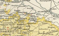
 The area of the Chaube Jagirs in the Imperial Gazetteer of India | |||||||
| Area | |||||||
• 1901 | 34 km2 (13 sq mi) | ||||||
| Population | |||||||
• 1901 | 1,232 | ||||||
| History | |||||||
| History | |||||||
• Established | 1812 | ||||||
| 1948 | |||||||
| |||||||
Kamta-Rajaula was a princely state in India during the British Raj.
History[edit]
It was one of the Chaube Jagirs, part of the Bagelkhand Agency which was merged into the Indian state of Vindhya Pradesh in 1948.
Kamta-Rajaula was a place of pilgrimage, for according to legend it was one of the places where Rama had been.[1] The capital was the village of Rajaula, located at 15 km from Karwi railway station.
Rulers[edit]
The rulers of Kamta-Rajaula were titled 'Rao'.[2][3]
Raos[edit]
- 1812 - 1874 Gopal Lal
- 1874 - 1892 Bharat Prasad
- 1892 - 1906 Ram Prasad
- 1906 - 1946 Radha Kishan
- 1946 - 1947 Rajiv Nandan Prasad
See also[edit]
References[edit]
- ↑ Great Britain India Office. The Imperial Gazetteer of India. Oxford: Clarendon Press, 1908
- ↑ Indian Princely States
- ↑ "Indian states before 1947 K-W". www.rulers.org. Retrieved 20 August 2019.
Coordinates: 25°11′N 80°51′E / 25.183°N 80.850°E