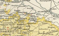
Chaube Jagirs
This article needs additional citations for verification. (April 2017) |
| Chaube Jagirs | |||||||
|---|---|---|---|---|---|---|---|
| Jagirs | |||||||
| 1812–1948 | |||||||
 The area of the Chaube Jagirs in the Imperial Gazetteer of India | |||||||
| Area | |||||||
• 1901 | 247 km2 (95 sq mi) | ||||||
| Population | |||||||
• 1901 | 20,711 | ||||||
| History | |||||||
| History | |||||||
• Established | 1812 | ||||||
| 1948 | |||||||
| |||||||
The Chaube Jagirs, also known as 'Kalinjar Chaubes', jagir states were a group of five feudatory states of Central India during the period of the British Raj. They were a British protectorate from 1823 to 1947 and belonged to the Bagelkhand Agency. Their last rulers acceded to India in 1948.[citation needed]
History[edit]
Until the 18th century the original lands of the family had been in Dadri, near Nowgong cantonment. Once under the service of Raja Chhatrasal of Panna State, the Chaube Brahmin officials rose from gentry to nobility. The owners of the first four estates were descendants of Ram Kishan, the former governor of Kalinjar under Raja Hirde Sah of Panna.[1][clarification needed]
In 1862 the jagirdars were granted a sanad of adoption. The rule was that when there were no heirs the estate was split between the other members. Initially there were nine principalities but in 1839 two were already extinguished. In 1855 one estate was seized owing to the implication of the ruler in a murder case. Also in 1864 another principality was extinguished and thus only five remained. [2]
The Jagirs were under the Bundelkhand Agency of the Central India Agency until 1896 when they were transferred to the Baghelkhand Agency.[3] In 1931 they were transferred back to the Bundelkhand Agency.[4]
Chaube estates[edit]
The estates were:
Annexed by the British[edit]
Three states were confiscated by the British:[citation needed]
- Purwa with 9 villages and an area of 53.18 km2 (annexed in 1855)
- Nayagaon with 18 villages and an area of 65.11 km2 (annexed in 1864).
See also[edit]
References[edit]
- ↑ "History of Satna". Satna District Administration. Retrieved 18 August 2010.
- ↑ Columbia-Lippincott Gazetteer p. 1414.
- ↑ Great Britain India Office. The Imperial Gazetteer of India. Oxford: Clarendon Press, 1908
- ↑ Imperial Gazetteer of India