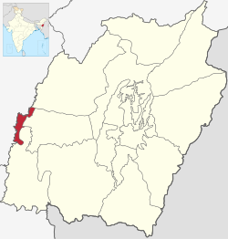
Jiribam district
This article includes a list of general references, but it remains largely unverified because it lacks sufficient corresponding inline citations. (June 2017) |
Jiribam district | |
|---|---|
 Location of Jiribam district in Manipur | |
| Country | |
| State | File:..Manipur Flag(INDIA).png Manipur |
| Established | 2016 |
| Headquarters | Jiribam |
| Area | |
| • Total | 232 km2 (90 sq mi) |
| Population | |
| • Total | 43,838 |
| • Density | 190/km2 (490/sq mi) |
| Time zone | UTC+05:30 (IST) |
| Major highways | NH-37 |
Jiribam District is a district in the state of Manipur, India. It was created in December 2016 from the Imphal East district.[1]
Sub-divisions[edit]
The following are the sub-divisions in Jiribam district:
Demographics[edit]
Languages in Jiribam[2]
Bengali (50.80%)
Meitei Manipuri (30.51%)
Hmar (8.04%)
Bishnupriya Manipuri (2.67%)
Hindi (1.94%)
Kabui (1.46%)
Kuki (1.11%)
Paite (0.79%)
Khasi (0.52%)
Others (2.16%)
The main language spoken in Jiribam is Meiteilon, followed by Bengali, Hmar, Bishnupuriya Manipuri, Hindi, Rongmei, Kuki etc.
References[edit]
- ↑ "History of Imphal East". Imphal East district. 2 November 2019. Retrieved 27 November 2019.
- ↑ "Census of India Website : Office of the Registrar General & Census Commissioner, India".
- ↑ "7 new districts formed in Manipur amid opposition by Nagas". Indiatoday.intoday.in. 9 December 2016. Retrieved 30 June 2017.
- ↑ "Manipur Creates 7 New Districts". Ndtv.com. 9 December 2016. Retrieved 30 June 2017.
- ↑ "New districts to stay, says Manipur CM". The Hindu. 31 December 2016. Retrieved 30 June 2017.
- ↑ "Manipur Chief Minsiter [sic] inaugurates two new districts amid Naga protests". Timesofindia.indiatimes.com. 16 December 2016. Retrieved 30 June 2017.
- ↑ "Simply put: Seven new districts that set Manipur ablaze". The Indian Express. 20 December 2016. Retrieved 30 June 2017.
- ↑ "Creation of new districts could be game-changer in Manipur polls | opinion". Hindustan Times. Retrieved 30 June 2017.